STONE MEADOWS
HABITAT MANAGEMENT PLAN
        2015-2020
←
→
Page content transcription
If your browser does not render page correctly, please read the page content below
STONE MEADOWS
HABITAT MANAGEMENT PLAN
2015-2020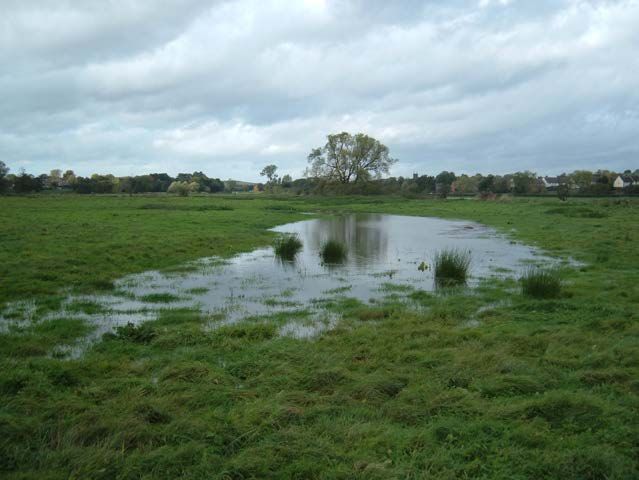
Contents
1. Introduction .................................................................................................................... 3
2. Site description .............................................................................................................. 3
3. Management objectives .............................................................................................. 5
3.1 Table of Main Management Tasks ............................................................................. 5
4. Main management operations ...................................................................................... 6
4.1 Grassland Management ............................................................................................... 6
4.2 Wetland Management .................................................................................................. 7
4.3 Woodland and Hedgerow Management ....................................................................... 9
4.4 Other Site Management Tasks ................................................................................... 11
Contact for further Information: ........................................................................................ 14
Appendix One - Maps ....................................................................................................... 13

Executive Summary
Stone Meadows consists of two floodplain meadows, either side of the town of Stone,
totalling 14ha in size. The main aim of site management is to restore the meadows to
species-rich floodplain meadows. Tenant farmers currently graze both sites, which helps
site management. Regular annual management is required to maintain and enhance this
work. This includes the day-to-day management of the site including site surveys and
general maintenance. Annual maintenance costs will be approximately £1500. Details of
the works are found in the main body of the text and include:
    • Vegetation control
    • Scrub/tree control

By managing the Borough’s natural assets the Council is following national and local
policy set out in:
NERC Act 2006 – Section 40 & 41
Corporate Plan – Cleaner, Greener, Safer.

                                                                  2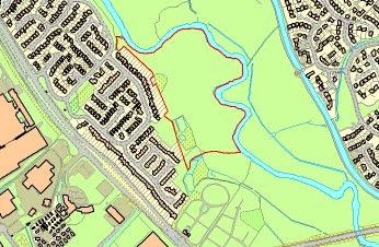
1. Introduction

The Goodall Meadow has only one access point, which is situated on Trent Road. This
access point consists of a small lay-by with a locked field gate (to allow vehicular access
for Stafford Borough Council, the grazier or contractors) and a self-closing kissing gate,
which is designed to allow access for wheelchairs and pushchairs as well as pedestrians.

The Southern Meadow has two access points, one off Valley Road and the other via an
area of grassed amenity public open space just off Redwood Avenue. Both of these
consist of locked metal gates, which provide authorised vehicular access to the site but
prevent grazing livestock from leaving the meadow. The Valley Road access point will be
improved to provide better access to the meadow for the grazier and the public.

Since local residents currently use the Meadow to walk their dogs they will be allowed to
continue doing so. However, they will be required to keep their pets on a lead and under
close control. Owners must clear up after their pets and remove faeces from the site.

Name: Stone Meadows                               Total area: 13.9 hectares

The Local Nature Reserve is comprised of two meadows- Goodall Meadow is 8.4
hectares in size and Southern Meadow covers 5.5 hectares.

Grid reference: SJ895340 (Goodall Meadow) and SJ909326 (Southern Meadow)
OS Map: Explorer 258 - 1:25,000

Ownership: Stafford Borough Council

Local Planning Authority: Stafford Borough Council

District: Stafford Borough      Conservation Status: Local Nature Reserve (LNR).

Management History: This document updates and replaces the 2010-2015 Management
Plan and is the second update since the site was declared a LNR in 2004.

Access: Members of the public are welcome to enter both of these meadows, but their
location alongside the River Trent imposes geographical constraints on access. There are
no formal rights of way or paths on either site.
The Environment Agency has been known to access Goodall Meadow to clear blockages
on the stream boundary. Network Rail has accessed the Goodall Meadow for
maintenance/improvement works to the railway embankment and viaduct.

2. Site description
The Goodall Meadow is situated in the north-western corner of Stone, close to the Walton
Inn on the A34, and is almost entirely bounded by water courses. The River Trent
meanders along the western and southern perimeter of the site. The eastern boundary is
marked by a small straight drainage ditch which separates from the River Trent just to the
north of the site and re-joins the main river alongside the old Trent Hospital building in the
south-east corner of the meadow. The short northern boundary is provided by Trent Road.

                                              3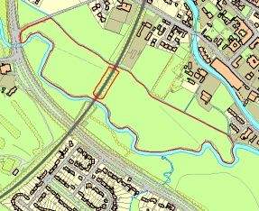
Much of the meadow is low lying and contains archaeologically important flood meadow
field systems. However, there are also a series of large earthworks created during the
Foot & Mouth crisis that provide higher land. The grassland on this meadow has been
agriculturally improved in the past, and botanical diversity is not sufficient for SBI status.
The meadow is bisected by a railway line which runs roughly north-east to the south-west
through the centre of the site on a large embankment owned by Network Rail. All site
users, including vehicles, can travel between the two halves of the meadow via either of
two short tunnels in the embankment.

The Southern Meadow is located in the southern end of Stone, close to the cemetery and
the A34/A51 road junction. The River Trent runs along the northern and eastern edge of
the site, whilst residential gardens provide the western boundary. Privately owned
farmland lies to the south of the meadow, beyond a boundary hedge. The meadow is an
area of flat, relatively low-lying ground on the River Trent floodplain. The predominant
vegetation types are improved and semi-improved grassland, but the southern and
western edges of the meadow provide greater botanical interest. There is a diverse area
of wet woodland that has developed around two small ponds in the south-western corner
of the meadow. These wet habitats are fed by a small watercourse, which runs from
higher ground to the south of the site. By the time it reaches Southern Meadow water flow
is almost entirely underground. This phenomenon provides a wet grassland habitat to the
north of the wet woodland.

Ecological Evaluation

Southern Meadow

Trees:
On entering the site, the first tree to be seen is a fine specimen oak. A mature Black
poplar is the largest and most impressive tree on site (see section 4.3.3). A group of
Aspen are located nearby. Several Crack willow form a group by the river in the centre of
the reserve. Willow and Alder are the dominant tree species in the wet woodland area.

Plants:

Birds:
During the summer, impressive numbers of House martin feed across the site and river.
On sunny days in June, these birds can be seen collecting mud from the river bank for
their nests. The occasional Sand martin can also be spotted in amongst them. It may be
possible that they attempt to nest in the mud banks of the river. Swallow can also be
seen. On the river, a Kingfisher is possible though rare. Also occasionally spotted are
Mandarin duck and Goosander. Mute swan can be seen and are often on the floodplain
during winter. Grey heron and Moorhen are regularly seen. During winter, Snipe have
been recorded feeding in the wetter sections of the meadow. Corvids and buzzard often
fly over.

                                               4
3. Management objectives
Local Nature Reserves are a very important part of our heritage and it is important that we
treat them as such. We want to encourage and enhance biodiversity within our Borough
and encourage as many of our residents to visit and to enjoy our LNR’s.
• To enhance the grassland habitats on both meadows, by encouraging a greater floral
diversity.
• To maintain and enhance, and where possible create or restore, wetland features.
• To ensure that all hedgerows on the meadows are managed appropriately to provide
maximum wildlife benefit and, where necessary, stock-proof boundaries.
• To maintain and enhance the populations of notable species, such as native black
poplars, snipe and barn owls.
• To enhance the educational value of the site and increase the number of educational
visitors.
• To contribute towards achieving the aims, objectives and targets that are identified in
the UK Biodiversity Action Plan, the Staffordshire Biodiversity Action Plan and the
Stafford Borough Biodiversity Strategy
3.1 Table of Maintenance Tasks
Works Date
Grazing Agreements March
Surveys Apr - July
Himalayan Balsam Control June
Check Barn Owl Boxes Summer
Hay cut July
Pollarding Nov - Feb
Wet Woodland Management Nov - Feb
Hedge management Nov - Feb
54. Main management operations
This section details the main management operations that are required to protect and
enhance the biodiversity of these meadows and also maintain their community amenity
value. A new management plan should be produced during 2020 to succeed this
document. This current plan should be monitored throughout its 5-year lifetime and should
be revised at any time during that period, if necessary, to provide greater protection to the
important habitats and species that are found on this site.
4.1 Grassland Management
As the name “Stone Meadows” suggests both of these sites are predominantly grassland
habitats. Cattle and sheep have traditionally grazed the meadows and this management
technique will continue in some form. Stafford Borough Council own both meadows and
grazing is arranged via agreements with local farmers. In 2001 the meadows were
entered into the Countryside Stewardship Scheme as Lowland Pasture. In 2012 this was
succeeded by a Higher Level Stewardship (HLS) agreement with the aim of enhancing
the meadows floristically.
4.1.1 History of management
• In 2001 Stafford Borough Council entered both meadows into a Countryside
Stewardship Agreement, which aims to increase the biodiversity of the sites. The
number of livestock on the meadows has been reduced to prevent over-grazing and
practices such as the addition of fertilisers and ploughing are prohibited.
4.1.2 HLS - General Requirements
• Inorganic or organic (e.g. farmyard manure) fertiliser, lime, slurry, sewage sludge or
slag must not be applied to the meadows.
6• Pesticides must not be applied except for the control of spear thistle, creeping or field
thistle, curled dock, broad-leaved dock, common ragwort or, with prior DEFRA / NE
agreement, nettles. Application must be by weed wiper or spot treatment.
• There must be no ploughing or other cultivation, reseeding, rolling or chain harrowing.
The only exception to this is if such operations are required as part of work to enhance
the natural floral diversity of the grassland
• There must be no new drainage or modification to existing drainage systems. This
includes subsoiling and mole ploughing.
• Where Livestock Units per hectare are referred to in the following section, the units
below should be used to calculate stocking rates:
⇒ Dairy cow 1.0 LU
⇒ Beef cow (excl. calf) 1.0 LU
⇒ Cattle over 2 years old 1.0 LU
⇒ Cattle between 6 months and 2 years old 0.6 LU
⇒ Ewe and lamb 0.15 LU
⇒ Hill ewe and lamb 0.10 LU
⇒ Ram and tegs over 6 months 0.15 LU
• There must be no use of metal detectors or ground disturbance on sites of
archaeological interest without prior written consent from DEFRA.
• Pigs/poultry/horses/ponies/donkeys must not be allowed to graze on Agreement land.
• Graze at a stocking density of no more than 1.0 Livestock Units/hectare at any one
time between 1st April and 15th July. This is to minimise disturbance to ground nesting
birds/ damage to flowering plants/ damage to archaeological sites.
• There must be no supplementary feeding of any description, including creep feeding.
• Spear/Creeping Thistles are to be controlled by cutting. The first cut must be prior to
flowering and a minimum height of 150mm (6 inches). A second and, if necessary, a
third cut must be made to control secondary growth and prevent late seeding. These
cuts should be at a minimum height of 40mm (1.75 inches).
4.2 Wetland Management
The two meadows contain a variety of wetland features, ranging from fast moving riverine
habitats to a heavily vegetated pond/wet woodland environment.
4.2.1 Pond area and wet woodland on Southern Meadow
• Old Ordnance Survey maps of Southern Meadow show formalised ponds on the
western boundary of the site. Even modern computerised mapping information
identifies a roughly rectangular water body and a smaller oval pool in this location. In
reality this is now a small area of wet woodland, which contains a mix of open water
features and marshy vegetated ground. The woodland canopy is predominantly crack
willow (some of which are standing deadwood) together with a few alders. The under-
storey contains regenerating crack willow, alder, goat willow and some sycamore.
Ground flora species include common bistort, meadowsweet, yellow iris, water mint,
marsh marigold and water horsetail. As this area provides both the largest woodland
copse and the only permanent standing water on the site it provides a valuable habitat
for a variety of fauna.
7• Management of this area will aim to maintain a mix of wetland habitats.
• Natural regeneration of willow species and alder should be encouraged. In 2003 a new
fence was installed around the woodland to prevent access by cattle and therefore
prevent grazing of natural regeneration. The fencing was extended during the spring of
2004 to allow the woodland to expand slightly. However, it is important that tree growth
does not significantly affect the water budget of this area and therefore a further
increase in the woodland (beyond the new fenceline) is not currently envisaged.
• The composition of the tree species should be closely monitored. If sycamore trees
seem to be increasing in number rapidly then selective removal will be required. This
invasive, non-native, tree species has the potential to significantly affect the
composition of woodlands if left unchecked.
• Any standing deadwood should be left unless it is considered to pose a Health and
Safety risk to site users or neighbouring residences. If felling is deemed to be
necessary then the cut deadwood should be left on the ground within the woodland to
provide habitat diversity.
4.2.2 Flood meadow field system on Goodall Meadow
• Staffordshire County Council’s Historic Environment Officer (Archaeology) has
identified this as an important archaeological feature.
• The flood meadow field system consisted of a series of shallow channels, which were
used to retain floodwaters on the meadow each year. The nutrients and extra moisture
that these channels held prompted more vigorous growth of grass.
• These shallow channels, the majority of which run in rows parallel to the River Trent,
can still be identified on the site today.
• It is important that the remnants of the flood meadow field system are conserved.
Consequently, there must be no heavy disturbance of the ground surface (including
ploughing) on the low-lying half of the meadow.
4.2.4 Control of Himalayan Balsam
• Like much of the River Trent the sections of water course that flow through the Goodall
and Southern Meadow in Stone are badly affected by Himalayan Balsam. This
invasive, non-native, plant bares attractive pink flowers from mid-summer until early
autumn. It is an annual, which grows vigorously and swamps much of the natural
bankside vegetation. Each plant produces hundreds of seeds, which are then
transported downstream.
• It will be very difficult to eradicate Himalayan Balsam from the drainage ditch on
Goodall Meadow and the River Trent on both sites because there are a very large
number of plants further upstream. Therefore, each year a huge number of seeds will
continue to be produced, which will then be transported to Stone by the river. Even so,
it is important that efforts are made to control Himalayan Balsam on these meadows.
As the plant is an annual it is vital to prevent it from setting seed. Manual pulling or
mechanical strimming are the preferred methods of control. This work should be
undertaken in June as vigorous plant growth begins. Further control work may then be
required throughout the summer months to ensure that later germinating seeds are not
missed.
8• Control of Himalayan Balsam is important not only to enhance the bankside habitat on
these meadows, but also to prevent Stone Meadows from being a donor site that
facilitates the spread of Himalayan Balsam further downstream.
4.2.5 Riverbank re-profiling
• In 2003 plans were drawn up to undertake two sections of riverbank re-profiling on this
meadow. These were funded by the Environment Agency, who also funded work on
another section of re-profiling, which was completed in November 2003 on the nearby
Crown Meadow.
• Over the past two hundred years most of the River Trent has been ‘canalised’ - a
process that results in steep banks, flat riverbeds and fast flows. This greatly reduces
the diversity of habitats within the river and on its banks. One of the main reasons for
‘canalisation’ was the belief that it would reduce flooding problems. However, it is now
known that fast flowing rivers can result in ‘flash floods’ downstream.
• The process of riverbank re-profiling involves re-instating the natural contours of the
land by removing ‘wedge-shaped’ sections of the riverbank using earth-moving
machinery. This results in much gentler slope gradients (see diagrams below). By
reducing the gradients of the banks the re-profiling work will provide an opportunity for
natural bank-side vegetation, such as reeds and rushes, and riverbed features, such
as shingle-bars, to develop. This increased diversity of habitat will, in turn, benefit a
variety of animal life, particularly birds and insects which will return to the area over
time. As well as wildlife, the work will benefit people living near by. The sections with
gentler banks will make it easier to see the river and safer for people walking
alongside. It will also provide an opportunity for the river to be safely used as an
educational resource.
• However, the process of re-profiling a section of riverbank generates a tremendous
amount of surplus topsoil. On many sites this material could be incorporated into other
habitat restoration/creation projects. Unfortunately virtually all of Southern Meadow lies
within the floodplain of the River Trent. No material should be deposited within the
floodplain (because this would reduce flood capacity), so all surplus soil produced
would have to be transported off-site. The sustainability and cost of transporting
material away from the site, together with restricted vehicular access to the meadow,
have resulted in this planned habitat enhancement work being indefinitely postponed.
However, if circumstances change and a sustainable, financially viable, way of
carrying out the work can be found then the project should be implemented.
4.3 Woodland and Hedgerow Management
Around two meadows there are a variety of woodland, hedgerow and scrub habitats.
These all provide valuable habitat diversity and should be managed sensitively to benefit
the associated ground flora and the fauna that utilise these habitats. If new planting is
planned then only appropriate native tree/shrub species should be strongly encouraged
on these meadows.
4.3.1 Hedgerows
9• Hedgerow restoration work was undertaken on the hedge that marks the southern
boundary of Southern Meadow during 2003. The hedge had become very gappy and
had clearly neither benefited from hedge laying nor gapping up work for a considerable
length of time. Hawthorn and Blackthorn whips were the dominant species used in re-
planting, although species such as dog rose, alder and crab apple were also planted.
The planting density was approximately 6 per metre (in two staggered rows to produce
a denser hedgerow). Stock-proof fencing was installed around the ‘gapped up’ hedge
to prevent cattle from grazing the young trees. All of this work was funded by the On
Trent project.
• In 2004 hedgerow restoration work was carried out on a hedge that runs through
Goodall Meadow. The remnant hedgerow was comprised of a series of old hawthorn
trees, which had clearly been planted in a linear fashion but displayed no sign of
having been laid in the past. The hedgerow was gapped up with a variety of local
provenance species including hawthorn, hazel, crab apple, dog rose and buckthorn.
• The northern boundary of the Goodall Meadow, which runs alongside Trent Road, is
marked by a hedgerow. As this is a roadside hedge it is essential that the hedge
remains stock-proof and does not cause a risk to public safety by growing into the road
or obscuring road signage. The roadside part of the hedge therefore requires annual
trimming to prevent encroachment onto this narrow road. This cutting should take
place during January or February.
4.3.3 Black poplars
• The Black Poplar is a rare native British tree, which is naturally found on lowland river
floodplains and is therefore ideally suited to the conditions on Stone Meadows. Native
Black Poplars are now very rare because the remaining mature trees are not
producing saplings. This is because their seeds need very specific wet, muddy ground
conditions to successfully grow. However, in the last 300 years suitable conditions for
the establishment of these majestic trees have virtually disappeared because of
changing farming practices and land drainage. Some black poplars still survive locally
and to promote the survival of this species Staffordshire County Council are growing
new trees by taking cuttings from the remaining mature trees. The native black poplar
is a Staffordshire Biodiversity Action Plan species.
• There is a large mature poplar tree close to the riverbank on the northern edge of
Southern Meadow.
• In early 2004 several native black poplar saplings were planted in Stone. Three of
these were on Southern Meadow (1 in the wet woodland, 1 amongst the mature trees
on the riverbank and 1 by the patch of trees on the western boundary), one was on
Goodall Meadow (close to the riverbank at the end of the restored hedge) and two
were on the nearby Crown Meadow. These saplings were kindly donated by
Staffordshire County Council. Where necessary the trees were fenced off to prevent
grazing or fitted with tree shelters.
• Once the trees are considered to be developed enough to be safe from grazing and
rabbits, the fencing should be removed.
4.3.4 Other tree management tasks
10• Whenever possible ropes should be removed from the branches of trees, although
only if it is safe to do so. Old tree ties should also be removed from any planted trees.
• Bird boxes and bat boxes could be installed in appropriate locations on some of the
mature trees around the meadows.
4.4 Other Site Management Tasks
There are numerous general site management tasks that need to be undertaken. Many of
these are undertaken by the graziers – or because they are on site on a day-to-day basis
are the best wardens for the site and notify us of any problems.
4.4.1 Access
• Monitoring of the condition of all access points should be undertaken regularly.
• It is essential that all site boundaries are maintained in a stock proof condition and
un-authorised vehicular access is prevented. Any necessary repairs should be
arranged as soon as possible. For the duration of the annual grazing agreements for
these meadows the graziers are responsible for maintaining site boundaries.
4.4.3 Signage
• New Local Nature Reserve information boards will be installed on both meadows.
4.4.4 Wildlife Surveys
• To get a better overall understanding of the wildlife that uses this site a number of
surveys should be undertaken. As previously stated in section 5.2.1 it is particularly
important to get more information about the wet woodland/pond area on Southern
Meadow. It would also be beneficial to have general survey data relating to birds,
reptiles, dragonflies, damselflies, butterflies and moths that use the meadows.
• All wildlife records that are collected, whether historical or current, should be reported
to the Staffordshire Ecological Record (SER).
4.4.5 Invasive Species Control
• The meadows should be monitored for the presence of invasive plant species such as
Japanese Knotweed or Giant Hogweed.
• Any ragwort on the meadows should be manually removed (using gloves) before it can
set seed. The extracted plants should be bagged, removed from the site and safely
disposed of. The graziers are responsible for this work, as their livestock would be
affected should they leave it in place.
• Thistles should be topped in June and again in July before flowering
11Ecolog
ical
Positio
n and
Green
Infrast
ructur
e
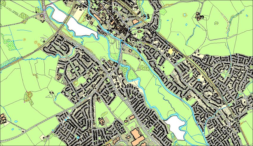
Map of Trent corridor in Stone, the LNRs highlighted in white.
In between the two LNRs are Stone Town Council’s Crown Meadow, Westbridge Park
and several areas of land owned by a local farmer. Although an area of open landscape,
Stone’s Trent corridor does not fulfil its potential as a wildlife rich area. By considering the
whole length of the river corridor and adopting the broad aims of an overarching
Management Plan, the following potential benefits could be achieved:
• Improved quality of landscape
• Improved sustainable transport – footpaths
• Opportunities for education and informal learning
12• Having a positive impact on people’s health and well-being
• Climate change adaptation
• Flood risk reduction
• Improving the river corridor and green space networks
• Increasing access to nature and recreation
• Increasing wildlife
Although this
remains
aspirational, the
inclusion of this
area in the Local
Plan as designated
Green Infrastructure
shows the important
role this land plays
within the wider
landscape.
Floodplain
restoration work
at nearby Aston
Farm has clearly
shown the ecological
benefits
possible on this
section of the
Trent.
Appendix One - Maps
Goodall Meadow
13Southern Meadow
Contact for
further
Information:
Bill Waller –
Biodiversity
Officer,
Policy &
Partnerships
Team,
Stafford
Borough
Council
E mail:
wwaller@staffordbc.gov.uk
14Telephone: 01785 619000
15You can also read