STRATEGIC PLAN - International Cartographic Association
←
→
Page content transcription
If your browser does not render page correctly, please read the page content below
STRATEGIC PLAN
                                            for the

       International Cartographic Association

                                     2011-2019

Note
Although this document appears on the ICA website it is directed primarily at the ICA community
– officers and others working within the Association Some of the following account may seem self-
evident, but it is included for new members and as a benchmark against which misunderstandings may
be compared.

                                                1
International Cartographic Association Association Cartographique Internationale
International Cartographic Association                      Association Cartographique Internationale

     Foreword

     The International Cartographic Association is led by its Executive Committee, which
     undertakes the plans and activities that are endorsed by the General Assembly of member
     nations for implementation in the four years following each General Assembly. The
     Executive Committee is supported by the Chairs and vice-Chairs of Commissions and
     Working Groups, the Editor of ICA News, the Chairs of the Publications Committee, the
     Awards Committee, and the Statutes Committee.

     During the twenty-first century, the plans and activities of the Association have been directed
     by the Strategic Plan. The document you are now reading is a new edition of the Strategic
     Plan. It builds upon the previous plan (2003-2011) which included a review of the
     Association and provided a considered framework for developing the Association and
     advancing its aims. The previous work included an independent analysis by former ICA
     Vice-President David Rhind, presented at the 15th Conference/9th General Assembly in
     Bournemouth, UK, in 1991, and published in the Proceedings (Rhind, 1991). Professor
     Rhind‟s ideas and earlier contributions to EC discussions led to various changes, including a
     new set of aims, which is still in place today.

     This was followed by the publication of a formal Strategic Plan for 2003-2011, prepared by
     the ICA Executive Committee, with input from the Commission Chairs, and edited by former
     ICA President Michael Wood. A preliminary version was reviewed by former ICA President
     Joel Morrison, former ICA Vice-President Judy Olson and David Rhind. The Strategic Plan
     for 2003-2011 was adopted by the Delegates at the ICA General Assembly in Durban, South
     Africa in 2003.

     This document contains the Association‟s Strategic Plan for 2011-2019. It further develops
     the 2003-2011 Strategic Plan, and is presented as a set of guidelines for the management and
     development of the ICA over the next eight years. This Strategic Plan was developed by the
     2007-2011 Executive Committee, with inputs from Commission and Working Group Chairs
     and vice-Chairs. The initial document was further developed by a review group consisting of
     ICA Secretary-General & Treasurer David Fairbairn, former ICA Secretary-General &
     Treasurer Ferjan Ormeling, former ICA President Bengt Rystedt and Michael Wood.

     The Executive Committee of the International Cartographic Association presented this 2011-
     2019 Strategic Plan for approval at the Association‟s 15th General Assembly, Paris, France, on
     July 8th, 2011. It was subsequently endorsed by delegates representing member nations at the
     General Assembly and it forms the basis for developing strategic plans for growing and
     advancing the Association.

     William Cartwright
     President
     Paris, France, July 8th, 2011
International Cartographic Association Association Cartographique Internationale
Table of Contents
1 Introduction and background: The ICA Strategic Plan: 2011-2019 .................................... 5
2 Developments: Cartography and the International Cartographic Association .................... 8
3 Reflecting on where we are now: The ICA today: strengths, weaknesses, opportunities,
threats .............................................................................................................................. 12
4 Goals for ICA: Determining and meeting the strategies ................................................... 16
5 How ICA will implement the plan: The effect of Strategic Planning on ICA .................. 18
Appendices ........................................................................................................................ 19
Strategic Plan 2003-2011 outcomes ........................................................................ 19
Changes within specific operational fields...............................................................21
Using the Strategic Plan to create Operational Plans...............................................22International Cartographic Association Association Cartographique Internationale
1 The ICA Strategic Plan: 2011-2019
If ICA is to preserve its authoritative international role in Cartography and the relevant fields
within GIScience Science, a radical plan is required which will continue to stimulate a wide
range of research and professional activities and confront challenges identified. This plan,
directed at the ICA community, is written to maintain and develop ICA‟s standing. It also
addresses the development and use of Cartography and GIScience (GI).
This Strategic Plan has been written to identify strategic goals that ICA must strive to achieve
over the eight year period 2011 to 2019. The previous Strategic Plan (2003-2011) served ICA
well, and is available for reference via the ICA Website. Its structure, aim and outcomes have
been used to inform development of the current document, and its successes are noted in
Appendix 1. It should be noted that the current Strategic Plan will be supplemented by
Operational Plans, which will be drafted by the Executive Committee and Commission and
Working Group chairs after each General Assembly. Such Operational Plans will present
specific goals which can be used to assess the progress of ICA towards its strategic goals, and
also to govern its day-to-day business. Each Operational Plan will cover the four year period
between General Assemblies, but will be subject to significant review every two years.
Values
The International Cartographic Association respects the freedom and universality of
science, the equality of individuals and cultures1, and appreciates creativity and critical
thinking.
In terms of operating principles ICA abides by United Nations recommendations on
membership and freedom of scientific enquiry, and the ICSU declaration on the
universality of science.
ICA seeks the highest quality in theory, technology, standards guidelines and research.
ICA recognises its responsibilities to recognise, lead and develop the disciplines of
Cartography and GIScience for the benefit of society and humankind.
Vision:
The aim of ICA is to ensure that Cartography and GI are employed to maximum effect
and full potential for the benefit of society and science through promotion and
representation of the discipline and profession of Cartography and GI science
internationally.
Mission
To see ICA:
recognised by the wider scientific community and society as the world authoritative body
for Cartography and GI science, serving society in education and professional practice,
motivating individuals and organisations throughout the world.
play a leading role in the International Council of Science (ICSU), United Nations bodies
and the Joint Board for Geospatial Information Societies (JBGIS).
receiving professional and scientific recognition from individuals in all related fields
use its knowledge, experience and expertise to remain relevant and authoritative in the
representation of geography in its widest context.
1
Evidence: ICA is a non-governmental organisation acknowledged by the United Nations, and follows the rules
of the International Council of Science (ICSU).International Cartographic Association Association Cartographique Internationale
seeking the highest quality in scientific investigation, technical processes, and academic
enquiry.
raising the profile of Cartography and GI science to enable them to become indispensable
in all scientific and societal activities.
maintaining pre-eminence, but also collaborating with a range of communities, in
promoting research and scholarship in the disciplines of Cartography and GI science.
implementing its vision through its constituent parts – its member nations, Executive
Committee, its Commissions and Working Groups, and appointed Committees.
attracting membership from national Cartographic and GI science societies, universities,
government, and business and commercial organisations from every country of the world.
recognised for outstanding service to its members.
Objectives:
To contribute to the understanding and solution of world problems through the use of
Cartography and GI science in decision-making processes.
To foster the national and international use of geospatially referenced environmental,
economic and social information.
To encourage introduction of a focused geospatial basis for national and international
statistical information.
To provide global fora for discussion of Cartography and GI science.
To participate in meetings, dissemination and publication in concert with sister societies
and international organizations including the UN, sharing its vision with these
organisations.
To facilitate the transfer of new Cartographic and GI knowledge between and within
nations, especially to developing nations, and to undertake Capacity Building, notably for
communities in need.
To perform or to promote multi-national Cartographic and GI research, including
collaborative and trans-disciplinary research, in order to solve scientific and applied
problems.
To maintain a contemporary Research Agenda which is recognized as a leading and
authoritative document addressing humankind.
To enhance education in Cartography and GI science in the broadest sense through
publications, seminars, conferences, competitions and exhibitions.
To develop and promote the use of professional and technical standards, guidelines and
applications of theory in Cartography and GI science.
To demonstrate the utility of Cartography and GI science to all professions.
To offer its expertise and knowledge of technical developments to other organisations e.g.
governments, statistical bodies, GI management organisations etc.
To support map-related research in specific topics such as child education, history, theory,
and assistance for the visually-impaired.
To maintain a repository of knowledge disseminated through the work of Commissions
and Working Groups, Conferences, Workshops, publications and the Research Agenda.
Implementing the Plan
Growing from the Association‟s Vision and Mission, a number of strategies are outlined in
this document. These may involve future changes to the organisation and proposals to
improve structure and membership benefits: the strategies will have measurable goals so that
success can be quantified. They will govern activity within ICA for an eight-year periodInternational Cartographic Association Association Cartographique Internationale
(2011-2019). It is expected that these strategies will be supplemented by an Operational Plan
which will establish shorter-term, achievable targets over a sequence of 2 four-year periods.
Thus, strategic objectives and operational targets will be established, each supporting the
other. The former, whilst quantifiable, are intended to establish the direction of the
organisation, whilst the latter are more concerned with day-to-day activities and management
tasks. Commissions are expected to contribute to the specific development of the Operational
Plans.
Both the strategic and operational objectives will, ideally, direct the activities of the
Commissions (and be incorporated into their Terms of Reference), and improve organisation
in other areas of ICA activity.International Cartographic Association Association Cartographique Internationale
2 Cartography and GIScience and the International
Cartographic Association
The International Cartographic Association (ICA) is “the world authoritative body for
Cartography, the discipline dealing with the conception, production, dissemination and study
of maps.” The mission of the Association is to promote the discipline and profession of
Cartography and GIScience in an international context. The ICA is the prime international
body for Cartography and GIScience (see www.icaci.org for more information).
A history of Service, Growth and Achievement
The ICA was founded on June 9, 1959, in Bern, Switzerland. The idea to form an
international cartographic association was the concept of Carl Mannerfelt (Sweden).
Formation occurred after a number of preparatory conferences were held from 1956 to 1959,
during which the association was discussed.: the Esselte conference, Stockholm 1956; the
Rand McNally conference, Chicago 1957; and the DGfK conference, Mainz (Germany) 1958.
The first General Assembly (I) was held in Paris in 1961, at which the Statutes and
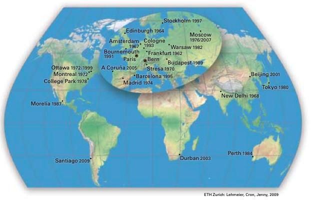
organisation of the Association were confirmed. Later conferences have been held around the
world from India (Delhi, 1968) to South Africa (Durban 2003), from Italy (Stresa, 1970) to
Mexico (Morelia, 1987), from Australia (Perth, 1984) to China (Beijing 2001), and to Chile
(Santiago, 2009). The map, below, illustrates the global reach of the ICA conferences and
associated General Assemblies.
Figure 1. Location of ICA conferences to 2009. Map courtesy of Bernhard Jenny.
The first President was Professor Eduard Imhof, of ETH Zurich, Switzerland, who held this
position between 1961 and 1964. Presidents who followed were:
Brigadier Dennis Thackwell, United Kingdom (1964-1968);
Professor Konstantin Salichtchev, USSR (1968-1972);International Cartographic Association Association Cartographique Internationale
Professor Arthur H. Robinson, USA (1972-1976);
Professor Ferdinand Ormeling, Netherlands (1976-1984);
Professor Joel Morrison, USA (1984-1987);
Professor Fraser Taylor, Canada (1987-1995);
Dr Michael Wood OBE, United Kingdom (1995-1999);
Professor Bengt Rystedt, Sweden (1999-2003);
Professor Milan Konečný, Czech Republic (2003-2007); and
Professor William Cartwright, Australia (2007-2011).
The ICA operates around an Executive, which consists of a President, up to seven vice-
Presidents, and a Secretary-General & Treasurer. Further important roles include the Editor
of ICA News, a webmaster, and the chairs of sub-committees. All of these positions are
voluntary. The Executive is elected by popular vote at the General Assembly, which takes
place every four years.
To achieve its aims the ICA operates through a number of Commissions and Working
Groups. It works with national and international governmental and commercial bodies, and
with other international scientific societies. It works closely with sister organisations through
its membership of the Joint Board of Geospatial Information Societies (JBGIS).
Commissions and Working Groups carry out the detailed work of the ICA. These
organisations have addressed the full range of scientific, technical and social research, which
is the mark of ICA activity.
The ICA promotes the generation of extensive publications, generally through its
Commissions and Working Groups. This activity provides a focus for Commissions and
Working Groups and allows for knowledge about advances in contemporary thinking and
research to be disseminated. The publications include books, ICA-recognised journals and
ICA News.
The ICA bestows awards for outstanding service to the ICA and to Cartography generally.
There are currently two major award categories:
• Honorary Fellowships – awarded to recipients who have made outstanding
contributions to the ICA; and
• Carl Mannerfelt Gold Medal – the highest award of the ICA, recognising excellence in
scholarship and research in Cartography and GI Science.
In addition, Diplomas for Outstanding Service to ICA may be awarded.
The ICA also rewards excellence in map design and production. At each International
Cartographic Conference, the Barbara Petchenik Children's World Map Competition is held.
Based on an exhibition of submitted children‟s maps from around the world, this
commemorates the work undertaken in the area of children and Cartography by the late
Professor Barbara Petchenik.
The activities of the ICA are important for promoting and advancing the theory and praxis of
Cartography. Throughout its history, ICA has brought together researchers, government
mapping agencies, commercial cartographic publishers, software developers, educators, earth
and environmental scientists, and those with a passion for maps. The cartographic world has
changed significantly since 1959 – the role and impact of ICA has been steadfast. Proud of itsInternational Cartographic Association Association Cartographique Internationale
traditions, ICA looks forward to the next decades with the hope that they will be as vibrant
and valuable as the first decades of its history.
Contemporary Cartography
As well as being statutory and commercial, the early aims and achievements of the ICA were
scholarly and scientific, embracing Cartography as a discipline. With the increasing influence
of new technology (especially computing and electronic communication) on map production
and use, Cartographers began examining more technical and management support topics. In
1959 the Cartographic profession within the national agencies and commercial companies was
distinctive and unchallenged. Now, developments in technology have helped „democratise‟
the Cartographic process (by means of user-friendly graphics packages for presentation, with
GI Systems for geographic data exploration and analysis, and with networks for data
provision, advanced geographic data handling, visualisation and representation). This has led
to a renewed interest in the discipline and the profession therefore continues to flourish with
products still ranging from paper maps to maps and atlases on the Internet, sitting alongside
less formal products. Such democratisation may carry its dangers (e.g. lack of appropriate
basic knowledge of Cartography and GIScience), but, more importantly, increasingly
interactive Internet mapping systems are quietly helping people rediscover their mapping
instinct, and learn to use Cartography (in its widest sense) rather than just pre-printed maps.
Not only are more maps used today but there is a growing pool of rudimentary
„Cartographers‟, and Cartography has regained its stature as a discipline of importance,
interest, innovation and impact. The „renaissance‟ of Cartography in recent years has resulted
in a dynamic combination of the mapping impulse, the technology used in handling and
disseminating geospatial data, the increasingly diverse and expanding role of Cartography in
everyday life, and the wide-ranging and innovative application areas and uses for maps.
The dynamism of Cartography
Not all members of the general public who exploit the potential of Cartography (exploratory,
analytical and communicative) are trained or competent in its use. Some, notably researchers
in Analytical Cartography (mathematical and analytical theory) and the developers of GI
system technologies, have exploited what have been referred to as the „deep structure‟ of
Cartography, to the enormous benefit of science and society. Many new Cartographic
products (such as maps and atlases on the Internet) are considerably enhanced by (and even
depend on) the functionality of such systems. Many of the problems associated with GI
systems such as mathematical Cartography, human-map interaction and generalisation, for
example, have been studied for decades or even centuries, and still apply. Cartography now,
therefore, embraces „GIScience Science‟, defined as “the set of fundamental issues arising
from the use of… GI systems” such as “scale, accuracy and the relationships between humans
and computers” (Longley et al 2001). It is obvious that, like GI system developers, those
involved in creating new dynamic and interactive maps and mapping systems are equally
dependent on GIScience Science.
It is clear that the landscape of Cartography has changed in the last decade. Map production
technology is now readily available to more and the maps themselves are much more varied in
terms of their provenance, appearance, and authority. Patterns of map use have also become
much more diverse. In addition, the use of geographic data, traditionally represented using
maps, has been extended and has led to further development in its visualisation and analysis.
The role of geographic data in a wide range of human, social, economic, scientific, and
environmental activities has increased. The result is that Cartography is being produced,
used, managed, disseminated, analysed, and archived by more people than ever before,International Cartographic Association Association Cartographique Internationale
through the use of a more diverse set of technologies, operating within a greater number of
scientific paradigms than before. Significant challenges exist which an international
association devoted to Cartography and GIScience must address.
ICA’s focus
These challenges can only be faced at an international level: the global initiatives, for example
the Millennium Development Goals, and a range of other societal projects promoted by the
United Nations, along with the developments leading to a truly „spatially-enabled society‟,
need to be addressed in a coherent and common manner, in which Cartography is important
and where ICA can lead. The adoption of new and more global aims, reflecting the
international vision of ICA‟s foundation years, has led to a more expansive policy of
interaction with sister societies and with international organisations. The ICA now sees itself
as part of a wider international initiative, addressing the problems of our planet and is
increasingly involved in scientific and technical matters such as geospatial data standards and
infrastructures, multi-scale issues, Internet and satellite mapping, and geospatial analysis and
modelling. The intention of such activities is to promote the efforts of the ICA by
participating in and contributing to major international research, now expressed in the ICA
Research Programme. These, and other, fields detailed above, are addressed by its
Commissions and Working Groups.
Changes in the ICA community catchment
The roots of ICA are in the national committees (where they exist) and their associated
cartographic/scientific societies, often the primary source of ICA officers, commission
members and funding. So intimate is this nourishing relationship that it does not take long for
ICA to be affected by changes in the economic health and well-being of these organisations.
For these reasons, we recognise that ICA is a member-led association, and its success depends
on the success of its members as they embrace, promote, develop, and use Cartography and
GIScience in their own nation. Potentially, such organisations will change, affecting the
relationship of member nations with ICA.
The wider picture and the ‘Fields’ of Cartography
ICA recognises a number of fields within which it operates. These are broad fields of human
activity to which ICA can contribute and from which many influences on ICA‟s strategy and
regular operations can be sourced. The fields are: Science and Technology, Education,
Professional Practice, Society, and Art.
1. Science (including technology): this field covers the development of the scientific and
technological basis of Cartography, GI science and geoinformatics.
2. Education: this field addresses the development and promotion, through education at all
levels, of the truths of what we know and have discovered about our subject.
3. Professional Practice: this considers the provision of support for two groups of
professionals,
a) those who describe themselves as professionally active – as their main occupation -
in a specific area of Cartography and GI science.
b) those who use systems or procedures from Cartography and GI science as part of
their professional activity, e.g. environmental managers, utility managers, planners.
4. Society (social and organisational): a field which seeks to promote applications of
Cartography and GIScience in any area that can be beneficial to Society in general. It also
covers the way in which regulation, legislation and political decision-making affect, and
are affected by, Cartographic and GI data handling practice.International Cartographic Association Association Cartographique Internationale
5. Arts: the exploration of aspects of design and aesthetics in cartographic artefacts, along
with the impact of creativity on the map production process and map use. This can
involve collaboration with members of the Arts communities, who represent geography
using methods that are different to those employed in the Cartography and GIScience
community or who theorise about „other‟ geographies.
Further discussion about how these fields affect the operations of ICA, notably the work done
by its Commissions, are specified in Section 4. In addition, Appendix 2 shows, in more
detail, the most important perceived changes within these fields – changes which inform this
Strategic Plan, and the Operational Plans to be developed. At this stage it is sufficient to
indicate that ICA must regularly scan, monitor, understand and respond to contemporary
development and changes in each of these fields, to determine their effect on ICA. Similarly,
the work of ICA can be usefully organised under these fields so that we can contribute to their
progress and promote an ICA perspective in them, now and in the future.International Cartographic Association Association Cartographique Internationale
3 The ICA today: strengths, weaknesses,
opportunities, threats
This section which is intended to give an authoritative picture of where ICA stands in 2011 is
presented as a SWOT analysis (strengths, weaknesses, opportunities, threats) which is
standard practice in strategic planning. The strengths and weaknesses relate to internal
practice, the opportunities and threats are externalities over which ICA has less control. This
SWOT analysis was performed using some of the challenges specified in Section 2, the points
made in the Strategic Plan 2003-2011, along with some of the successes and problems from
that plan, and some updated input from more recent consultation. Those three issues
perceived as being most important in each section are highlighted and worked through a
standard SWOT matrix in order to develop strategic objectives (see Section 4).
Strengths
Knowledge within ICA is special and unique, accumulated during over 50 years of
growth.
ICA‟s leadership is recognised internationally and its presence is also widespread.
The communications and information presentation methods of ICA, notably its website
and regular bulletin, ICA News, are excellent.
The current membership structure is sound.
There is strong support from member nations and affiliate members.
ICA‟s current organisational structure is „bottom-up‟ and therefore not regarded as
„distant‟.
The Association has good relations with sister societies in Geospatial Information,
through the JBGIS.
It is run by a core of dedicated, talented, volunteer workers.
The institutions of most ICA officers willingly offer support.
Commissions and Working Groups can show noted achievements and research output –
some have received wide international acclaim.
ICA is willing to consider its position and promote its identity through documents such as
this Strategic Plan, its Research Agenda, and its regular analysis of its scope and role.
Weaknesses
The vision and mission need updating.
The Association‟s ability to record and respond to the changing operational fields is not
good.
The organisation depends largely on voluntary workers from supportive institutions and
voluntary executive officers (some less active than others).
There is more pressure in general on dedicated individuals.
Insufficient nominations for key posts: only candidates with financial support can afford
to stand for office.
There is a lack of incentives to motivate officers, including Commission chairs.
Commission terms of reference can be weak and ill defined and not all work equally well.
Funding can be irregular and unpredictable: the reliance on national funding and fee
payment has not built headroom in the budget; subscriptions from (and engagement with)
non-governmental organisation can be irregular.
The growth in membership has been modest.International Cartographic Association Association Cartographique Internationale
Thus, financial resources are limited (there should be sufficient reserve funds for one
whole year).
Poor finances require sections of the ICA to find additional funds elsewhere.
Senior officers may have to restrict their travels (for both financial and time reasons),
although the necessity for increased travel is part of the new international community.
There are too many aims – and ICA tries to do too much.
Communication can be difficult at irregular intervals, with uncertain destinations.
The recent publishing record has been poor.
ICA‟s role in the international community is perhaps less prominent than it should be.
Major conferences still suffer from financial uncertainties.
There have been recent signs of loss of active member nations.
The organisation has been characterised as being open to new technology but closed to
new concepts.
Opportunities
The discipline of Cartography has an instinctive (map-related) attraction for many.
Cartography is based on well-established traditions – and is moving into a new phase of
evolution.
The subject retains its traditional nature and strengths but is expanding from the purely
presentational to provide more effective visual-thinking/decision-support tools.
It continues to evolve with contemporary technology.
Through maps, Cartography is increasing in level of usage in science and society, as it
offers effective solutions for the problems of science and society.
The new emerging activities in collaborative data collection, access and use (e.g. GeoWeb
of Volunteered GIScience (VGI)) and open source technologies could welcome the input
of an international organisation in Cartography.
Threats
With the introduction of computing and the growth of GI systems, the perception of
Cartography is less clear to many than it was in the past.
- Definitions may be dated and open to different interpretations.
- Cartography is primarily regarded as consisting of traditional static paper images.
- The subject is believed by some to have become wholly or partially redundant
with the growth of GI systems.
- Cartography is assumed by some to be only the output phase of a GI system.
- There is low awareness, outside our discipline, of how the modern subject has
developed.
- Previous scientific studies related to mapping, such as research into map reading,
could be included in GI science.
- There is inadequate explanation of our new field (i.e. beyond static paper maps).
- The rationale of Cartography is doubted by some rival groups.
There is possible loss of recognition of world leadership through changing outside views
of the nature and relevance of Cartography.
There is a view that a real reduction in the numbers of „traditional‟ professional practising
map-makers (Cartographers) is assumed to imply the demise of Cartography itself.
Democratisation of „Cartography‟ is believed to reduce the necessity for experts.
Cartography may be losing some status and identity by being seen as a subset of GI
systems/GI science.
Cartography is not benefitting specifically from funding opportunities in research, in
supportive production agencies etc.International Cartographic Association Association Cartographique Internationale
Technological, social and political changes can be difficult to read and react to.
A breakdown of inter-disciplinary boundaries has led to a blurring of responsibilities for
Cartography.
There is an instability in the model of operations in some governmental and commercial
agencies.
Our subject‟s ability to absorb new communities of volunteered GIScience suppliers, and
the open source software community, is limited.
The SWOT analysis is used to determine strategic objectives as reported in the next section.International Cartographic Association Association Cartographique Internationale
4 Determining and meeting the strategies
The SWOT analysis reveals a number of issues which ICA must address, in particular the
challenges outlined in the previous „weaknesses‟ and „threats‟ sections. This section attempts
to synthesise some of these challenges, suggests initial goals and methods of addressing them.
Because this section concentrates on the organisation itself, it is more focussed on internal
challenges („weaknesses‟), but „threats‟ are also considered here, along with preliminary ideas
of addressing them using „strengths‟ and „opportunities‟. The approach is based on a matrix
seeking worthwhile conjunctions of the strengths with opportunities (using strengths to take
advantage of opportunities) and threats (using strengths to avoid threats), and the weaknesses
similarly (take advantage of opportunities to overcome weaknesses, and reduce weaknesses
by avoiding threats). The intention is to determine 6-8 strategic objectives from the matrix.
Strengths: Weaknesses:
1. The communications and 1. Lack of incentives to
information presentation motivate officers
methods
2. Current organisational 2. Membership of ICA is not
structure is „bottom-up‟ expanding as it could
3. Commissions can show 3. ICA has too many aims
noted achievements and
research output
Opportunities:
1. Cartography has an S1-O1: appeal to lay public W2-O1: target other
instinctive (map-related) for individual membership membership categories
attraction S1-O2: advertise the role of W2-O2: target decision
2. Cartography is increasing Cartography better makers in affiliated
in level of usage in science organisations
and society S2-O1: let map users suggest W2-O3: target geographers
3. The new emerging the agenda of activities and geoscientists in new
activities in Geo-Web of S2-O3: new groups can self- areas
Volunteered Geographic organise under the ICA
Information (VGI) and open umbrella
source technologies
S3-O1: use the Research
Agenda to explore new
activities
S3-O2: promote
Commissions activities in
current areas using current
structure
S3-O3: Commissions can
show strengths in possible
new areas
Threats:
1. Some believe the field old- S1-T1: we have the strength W1-T2: re-direct money for
fashioned and that maps are to change our image in the incentives, including personal
traditional, static, paper media assistance to some officers,
2. There is declining funding S1-T2: publicise our results on a basis of equityInternational Cartographic Association Association Cartographique Internationale
for Cartographic activities, better to stem decline in
from research to production funding W2-T2: - increase
3. Our subject‟s ability to membership dues to ensure
absorb new communities is S2-T1: the strength to change financial stability
limited our image can be sought from W2-T3: strengthen efforts to
within engage new communities
S2-T3: change our ability to
absorb new communities W3-T1: reduce number of
from within aims, but have attractive
objectives
S3-T1: improve W3-T2: reduce number of
communication of novel aims
achievements W3-T3: have revised aims
S3-T3: - Commission covered by new communities
achievements can assist in
bringing in new structures
The following broad strategic objectives were sourced from this matrix:
1. Widening the awareness of map production and use – to maximise Cartographic activity
in the public arena (e.g. by education, by public engagement and exhibitions, by
encouragement of activities by national members): quantifiable objectives, more
Cartography courses, more attendance at relevant exhibitions
2. Ensure publicity for achievements – at all levels e.g. a formal publication of
achievements, higher quality of outputs in scientific literature, higher profile in the media:
quantifiable objective, publish achievements
3. Embrace new communities – to use our strengths in independent Commissions to
approach and work with new communities, including Volunteered GIScience and
crowdsourcing groups: quantifiable objectives, higher ICA presence in the alternative
cartographic community.
4. Examine all aspects of membership in order to increase number of members – new
categories, expanding range of affiliate members, recruiting more national mapping
agencies, membership fees, publicity for recruitment: quantifiable objective, to increase
membership
5. Maintain financial stability – funds are not large enough to support long-term
commitments to projects, but funds must be dispersed to maintain tax-free status:
quantifiable objectives, balance of income and expenditure
6. Continue to monitor Commission structure and effectiveness: quantifiable objective,
higher level of Commission activities, more active members in Commissions
7. Target geoscientists for joint activities – both at Commission level (most promising), and
at EC level (through JBGIS, initiatives of other organisations, running joint workshops):
quantifiable objective, increase number of joint activities and outcomes
8. Incentives for officers – primarily to ensure that people are willing to stand for office, and
mainly at a financial level (e.g. use part of Commission budget for chair‟s expenses,
preferential registration rate for ICC for officers): quantifiable objectives, more activity
by officersInternational Cartographic Association Association Cartographique Internationale
5 The effect of Strategic Planning on ICA
The adoption of strategic objectives outlined in Section 4 above will have impact on ICA‟s
procedures and structure. In addition, the subsequent Operational Plans, described at the end
of Section 1 are integral to the successful implementation of the Strategic Plan. Example
operational objectives which may inform the development of Operational Plans are suggested
in Appendix 3. The Operational Plans are the responsibility of each new Executive
Committee (elected every four years).
This section considers the impacts of the Strategic Planning process, and concludes the
document. The intention of the Strategic Plan is to ensure that ICA will become more
professional in nature, and will undertake its mission with efficiency and relevance.
In terms of ways forward, the following immediate actions result from the Strategic Goals
identified at the end of Section 4.
Maximising cartographic activity:
Increase the number of workshops and courses promoted by ICA, notably by its
Commissions.
Strive for high level of Commission activities and sufficient strength of Commission
membership.
Improve publicity (using ICA publications and the website) for both ICA and other
cartographically-related meetings/exhibitions/activities to increase number of
participants at these events.
Engage with a wide range of other groupings to ensure the widest possible involvement
of ICA with new activities in cartographic production, map use and alternative
communities.
Supporting capable officers through the following proposals:
Introduce motivational schemes (financial and career-path) for future ICA officers.
Encourage members of minority groups, young people, and people from developing
countries, to become involved in the ICA.
Investigate new forms of identifying senior officers and potential commission members.
Examine the possibility of having some paid officers, e.g. webmaster, executive director
(although this would create an imbalance with volunteers), whilst acknowledging that ICA
cannot currently afford to have paid officers.
Achieving good quality outputs from ICA:
Maintain the high standards of ICA News and the ICA website.
Improve the proceedings and publications from the ICC conferences and workshops.
Promote the achievements of ICA more effectively
Encourage Commission chairs to collaborate in activities which will lead to high-profile
dissemination of results.
Raising ICA‟s profile:
Increase membership, especially with affiliate members.
Undertake more collaboration with a wide range of organisations, including UN and
sister societiesInternational Cartographic Association Association Cartographique Internationale
Improving communication between ICA officers and membership and provide for a
continuous forum for discussion rather than a bi-annual one.
Use ICA publications, website and conferences to raise awareness of ICA activities.
Establishing efficient internal structures whilst maintaining the „bottom-up‟ approach
Examining the scope, value and structure of Commissions, and their groupings.
Ensure longer term financial planning and resource allocation, balancing income and
expenditure.
Approval, revision, timetable and resources
Approval and revision. This draft plan was circulated to members of ICA before the General
Assembly in Paris 2011. Suggested modifications were welcomed and incorporated where
appropriate. A session of the General Assembly discussed and voted on the acceptance of the
Strategic Plan.
Once approved, it was expected that the new Executive Committee, along with the newly
elected Commission Chairs, would quickly develop an Operational Plan to cover the period
2011-2015, with time dedicated at the International Cartographic Conference in 2013 to
assess and modify the Operational Plan where necessary.
Resources. Both the Strategic Plan and the Operational Plans will require resources to
implement. A provisional budget will also need to be approved by the General Assembly in
2011: this will direct resources towards the strategic objectives, and have the flexibility to also
direct resources to operational objectives. The resources available will be directly dependent
on the fundamental income stream – the membership fee. The current unit value (since 2007)
is €250.
The ICA Strategic Plan 2011-2019 has been written to give direction and set achievable and
quantifiable objectives. The Strategic Plan will set the agenda which ICA will adopt to meet
its mission in the long term, and (through the Operational Plans) will have considerable
influence on the day-to-day operation of ICA.International Cartographic Association Association Cartographique Internationale
6 Conclusion
The first ICA Strategic Plan was presented to ensure that ICA preserved “its authoritative
international role in Cartography (and in the associated fields of GIScience Science).” It was
suggested that important changes within the organisation were necessary in order for the
challenges of a new millennium to be met. The changes were to be introduced whilst ICA
continued to operate its wide range of research and professional activities.
Because it was the first Strategic Plan, a significant portion of the document looked
backwards in time to determine how ICA had reached its current position. This second
Strategic Plan, presented here, does reflect on history and also assesses the impact of the first
Plan, but the intention is to look forward. The General Assembly, as the primary decision-
making body in ICA, expects to have a working document available which can guide the
development of the Association into the future. The General Assembly meets every four
years: it has a strategic role to play in guiding ICA, and this Strategic Plan is intended to
present targets, create policy, visualise the future and expand the activities of ICA. It should
be referred to throughout the eight year period of its authority, by all those involved in ICA –
the Commission chairs, the national and affiliate members, the Executive Committee, the
leaders of other ICA committees, the conference organisers, and the individual members of
the representative national bodies which make up the General Assembly.
In addition, during those eight years, there will be a need for guidance for the day-to-day
operations of ICA. Addressing the same groups of people involved, it is expected that shorter
term operational plans will be developed by each new Executive Committee, to assist in
directing the ongoing work of ICA.
The Strategic Plan is presented here as a working document, to be supplemented by an
Operational Plan. The Strategic Plan is robust and visionary yet realistic: its goals should be
worth striving for, and should be capable of being achieved.International Cartographic Association Association Cartographique Internationale
Appendices
Appendix 1 Strategic Plan 2003-2011 outcomes
The SWOT analysis undertaken in the 2003-2011 Strategic Plan was somewhat unstructured,
but it did present a number of challenges: the success of these is considered in this Appendix.
ICA was charged with:
remaining relevant to its constituency. The ICA „constituency‟ was
considered to include national members, with varying characteristics; affiliate members,
which come from commercial, academic and institutional backgrounds; interested parties for
whom ICA acts in an advisory and supportive capacity, including international non-
governmental organisations and national governments; and other user groups. Relevance was
maintained by scanning the operational fields, by individual and group input into the basic
working units of the association – its Commissions and Working Groups, by leadership from
the Executive Committee, and by feedback from the membership. The relevance was
reflected by the ICA‟s outputs including international and regional conferences, workshops
and Commission meetings, participation in international initiatives, engagement with sister
societies, dissemination of ICA News and other publications, collaboration with ICA-
recognised journals, and the ICA website. [achieved: members, relevance, outputs
considered to have met this challenge; ongoing]
asserting use and ownership of Cartography. It was felt that the
increasingly seamless nature of science has led to some overlap of membership and interests
between sister societies. It was noticed that some have interests in Cartographic
representation and analysis (through geographical visualisation tools or GI systems). Like
language, Cartography cannot be „owned‟. It has many users and applications. But the ICA
was asked to continue to offer authoritative world leadership for the whole of Cartography, its
on-going strengths being reflected in the research fields of the research agenda and its
Commissions and Working Groups. Collaboration with other organisations is still regarded
as essential to ensure continued recognition of ICA‟s „footprint‟ within the fields of human
activity. [achieved: leadership and research activity both healthy; ongoing]
increasing the visibility of the organisation. This challenge was to be
addressed at two levels. Firstly, more general education of the public as to what Cartography
is (for the exploration, analysis and representation of GIScience) and what it is not (drawing
maps for paper production) would allow ICA to establish recognition as the representative
organisation for the discipline. Secondly, ICA was charged with promoting itself within the
discipline and achieve status as the pre-eminent organisation in the field of Cartography and
GIScience within the range of GIScience organisations. [partly achieved: ICA has a high
profile in official GI organisations, less so in informal organisations and wider society;
ongoing]
making better use of increasingly limited human resources. Although
the organisation‟s wider constituency may remain large and even increase, it was recognised
that the number of active members was likely to decrease in the short term. The pool of
potential members of commissions was specifically highlighted. It was suggested that the
ICA must take a more professional approach and consider the establishment of some paid
posts. [not achieved; ongoing]International Cartographic Association Association Cartographique Internationale
responding effectively to global geospatial initiatives. The increasing
number of world-wide initiatives demanding the application of Cartographic/GI science
expertise was noted. It was felt to be increasingly important for ICA to organise priorities of
response to, and procedures for action with, groups such as Digital Earth, ISCGM, Global
Spatial Data Infrastructure (GSDI), ISO, UNGIWG, and JBGIS. [achieved: MoUs and other
linkages established with other organisations to address world-wide initiatives]
widening the field of Cartography to include GIScience Science.
Although the concepts underlying Cartography have always been much wider, the ICA was
founded during the heyday of printed paper maps, and naturally, its first concerns were with
their conception, production and study. The design of maps and mapping systems (real and
virtual) remains a priority, but recent years have seen more technical commission themes
which reflect overlapping interests with, and the disappearance of boundaries between, other
mapping sciences. However, it is Cartographic approaches which have played the major role
in sourcing, developing and applying the theory and practice of geographic data handling. It
was felt appropriate, therefore, that the International Cartographic Association should include
Geographical Information Science as part of its vision. [partly achieved: although not
incorporated into the Association name, GIscience is accepted by the members of ICA and
individuals associated with it; ongoing]
Thus, 5 of the 6 challenges have been successfully addressed. It can be noted that these
challenges are not absolutely quantifiable, which makes it difficult to determine how
successfully they have been met. The strategic objectives outlined in the Strategic Plan 2011-
2019 will be more quantifiable and achievable.
Appendix 2 Changes within specific operational fields
This section examines what influences are affecting the nature of Cartography and GIScience.
Organised under the headings of the „fields‟ presented in Section 1, these issues have an
impact on our discipline. They may also, however, impinge on the ICA as an organisation,
and thus have influence on the strategic and operational goals which this Strategic Plan
presents. The SWOT analysis has taken many of these changes into account.
Science (including technology):
New scientific networks:
More interdisciplinary use of, and utilisation by, Cartography
Scientific enquiry operational on the Web
More effective literature and data search to assist in research
Technological changes:
Storage and archival improvements
Improvement of web-based communication
User-friendly mapping packages and flexible platforms for engagement (inc. mobile
devices)
Development of location-aware devices, and integration of contemporary real-world and
archival data-driven systems
Education and Professional practice:
Change in nature of both amateur and professional practice in all geosciences leading to
varying demands for educational coursesInternational Cartographic Association Association Cartographique Internationale
Decline in specific courses (at all levels) directed towards singularly Cartographic
education
Increasing demand for Continuing Professional Development
Recognition of continuing need for the training of personnel in developed and developing
countries
Role of Cartography in secondary schools is still uncertain and subject to broader
curriculum change
Society (Social and Organisational):
Changing societal needs, services and infrastructures will, in turn, affect mapping needs:
Informal educational facilities for different age ranges
Different business environments
Different holiday and recreational patterns
Daily needs of society (including everyday activities undertaken by consumers, citizens
and office holders)
New relationships between society and the environment driving Cartographic applications
in climate change research, disaster management, emergency planning
Growing awareness of spatial relationships and of the spatial context of location-based
services
New technical possibilities in social networking and related Cartographic data handling
Wider availability of smart machines and sensors
Organisations will be more specialised – leading to need for more co-operation
Arts
Increasing use of Cartographic images and sources in artistic endeavour, including multi-
media and digital art
Widening of design possibilities in representing multi-dimensional data and creating
representations on novel platforms
The design of Cartographic interfaces for both private (e.g. desktop access to
geobrowsers) and public (e.g. map products to guide navigation by public transport) use,
and map design in general, requires creativity which may be sourced in art
Appendix 3 Using the Strategic Plan to create
Operational Plans
As was suggested at the end of Section 1, ICA intends to create Operational Plans, governing
shorter term objectives, which will be informed by the strategic objectives listed in Section 4
above.
The creation of Operational Plans will use the discussion of ICA‟s operational fields, as
specified in Section 1, and explored further in Appendix 2. In this way, a series of operational
objectives can be presented, which will form the basis of the Operational Plans. The
objectives listed below, and the action points which derive from them, are examples which are
intended to assist the developers of the Operational Plans.
It is expected that many of these action points will be used to direct Commissions and
Working Groups, who are expected to prepare plans themselves, with objectives which can be
monitored and achieved during their four year term. Some of the action points below,
however, are specified as being the responsibility of other parts of ICA – the ExecutiveInternational Cartographic Association Association Cartographique Internationale
Committee, the Local Organising Committee of the International Cartographic Conference,
the sub-committees of ICA (Awards, Publications, Statutes), and the membership itself.
Science
objectives:
Promoting Cartography and GI science as individual subjects and clarifying the relationship
between them as well as with other geosciences by:
Strengthening the profile of scientific commissions in ICA.
Promoting international co-operation in scientific research on Cartography and GI
science, including fora for scientific discussions, dissemination of information and
scientific publishing in Cartography and GI science.
Actions:
Keep to the published advisory guidelines to improve the co-operation between the EC
(Executive Committee), the LOC (Local Organising Committee) and the commissions.
Maintain the ICA research agenda on key themes within Cartography and GI science
(EC).
Maintain research into spatial representation and visualisation facilities for spatial
exploration, modelling and analysis (specific Commissions, primarily those with a
scientific emphasis).
Review past studies and develop new research in map use, cognition, and aids to map-
reading and decision-making (specific Commissions, primarily those with an emphasis
on user issues).
Organise commission and cross-commission meetings (all Commissions).
Continue to support the international journal programmes on Cartography and GI
science (all parts of ICA ).
Update information on ICA publications, definitions and other related material in the
ICA and the commission home pages (Publications Committee).
Activate interactions between ICA and other scientific geographic societies as well as
those in computer science and statistics (EC).
Organise a scientific bookshop display during ICA conferences (LOC)
Update information on ICA and Cartography definitions and glossaries (all
Commissions).
Education
objectives:
Investigate ways to strengthen and monitor education programmes in Cartography, GI
science and related subjects at all levels (university, high school, elementary, life-long
learning).
Investigate fora for discussions of education programs and curricula in Cartography and
GI science.
Develop information networks and online courses on Cartography and GI science.
Offer educational courses for students on Cartography and GI science for example in
developing countries and for regional purposes.
Offer ‘master classes’ in GI systems/mapping to guide managers in spatial decision-
making
Investigate methods (and funding sources) to encourage the participation of students and
other young members in ICA activities.
Actions:You can also read