Streetscape Manual - A guide to the selection, design, installation and care of the District's streetscape and its historical preservation ...
←
→
Page content transcription
If your browser does not render page correctly, please read the page content below
Streetscape
Manual

A guide to the selection, design, installation
and care of the District’s streetscape and its
historical preservation.

Adopted April 2005

                                         BATH PRESERVATION TRUST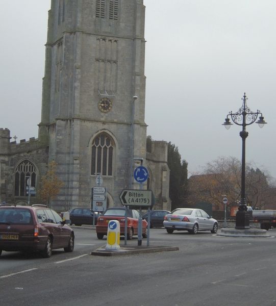
1   Introduction

                                                                                                         CONTENTS
    Objectives                                                                                       6
    Aims of the manual                                                                               6
    Audience                                                                                         7
    Organisation of manual                                                                           7
    Methodology for updating the Streetscape Manual                                                  7
    Methodology for using the Streetscape Manual                                                     7
    Sustainability                                                                                   7

2   Overview of the District’s streetscape history and character
    Street patterns, street management, street frontages                                             8
    Figure 1 – Characteristic areas of traditional building stone in Bath and North East Somerset    9
    Materials                                                                                       10
    Figure 2 – Bath Turnpike Trust roads                                                            11
    Street construction and laying patterns                                                         14
    Figure 3 – Turnpike Trust roads in Bath and North East Somerset                                 16
    Street maintenance                                                                              17
    Street furniture                                                                                18
    Glossary                                                                                        21
    Bibliography                                                                                    22

3   Overarching guidelines
    Introduction                                                                                    24
    Reinforcing local distinctiveness and improving the image of the District                       24
    Minimising visual clutter – minimum palette of materials and co-ordination of design            26
    Materials and workmanship, regular routine inspection, cleaning, maintenance
    and appropriate repair                                                                          27

4   Specific guidelines
A   Ground surfaces
    Review of natural stone and manmade paving materials                                            29
    Identification of paving materials                                                               30
    Proposed Actions for the Streetscape Manual                                                     31
    Natural stone                                                                                   31
    Reclaimed pennant                                                                               32
    Manmade paving products                                                                         32
    Installation of unit paving                                                                     33
    Tarmac                                                                                          33
    Pattern of laying paving (Bath)                                                                 34
    Pattern of laying paving outside Bath                                                           34
    Dealing with corners and changes of direction                                                   35
    Kerbs                                                                                           35
    Bedding for paving                                                                              35
    Jointing                                                                                        35
    Setts in the carriageway                                                                        35
    Bedding for setts in the carriageway                                                            35
    Dropped kerbs                                                                                   36
    Tactile paving                                                                                  36
    Review of mortar evaluation                                                                     37
    The present specification                                                                        37
    A new mortar                                                                                    37
    Key conclusions                                                                                 38
    Proposed Actions for the Streetscape Manual                                                     38
    Roadside verges                                                                                 39
B Street furniture
Comment 41
APC – automatic public convenience 41
Bollards 42
Bus stops and shelters 43
CCTV cameras 44
CCTV poles 44
Coal hole covers 44
Cycle racks 45
Feeder pillars 45
Lighting of buildings 46
Litter bins 46
Market stalls 46
Miscellaneous 47
Pay & display machines 47
Pedestrian guard railings 47
Pedestrian signage 47
Post boxes 48
Public art 48
Railings 49
Salt/Grit boxes 49
Seats – siting and useability 50
Street advertising 51
Banners 51
‘A’ boards 51
Fixed poster advertising 51
Street name signs 51
Table and chair licences 52
Temporary features 52
Telecommunication antennae 52
Telephone boxes / kiosks 53
Trees 53
Tree grilles 53
Resin bound gravel 54
Tree guards 54
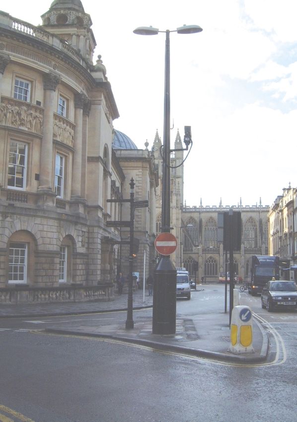
Street lighting 54
Locations of columns 54
Use of columns for signs 54
Cast columns and overthrows 55
Utility plant and junction boxes 55
C Traffic signs and road markings
Carriageway speed limit roundels 57
Colour 57
Directional signs 57
Fixings 58
Illuminated bollards 58
Parking and loading signs 58
Posts 58
Regulatory signs 59
Repeater signs 59
Road markings 59
Temporary signs 59
Traffic signals 59
Variable message signs 59
Warning signs 59
4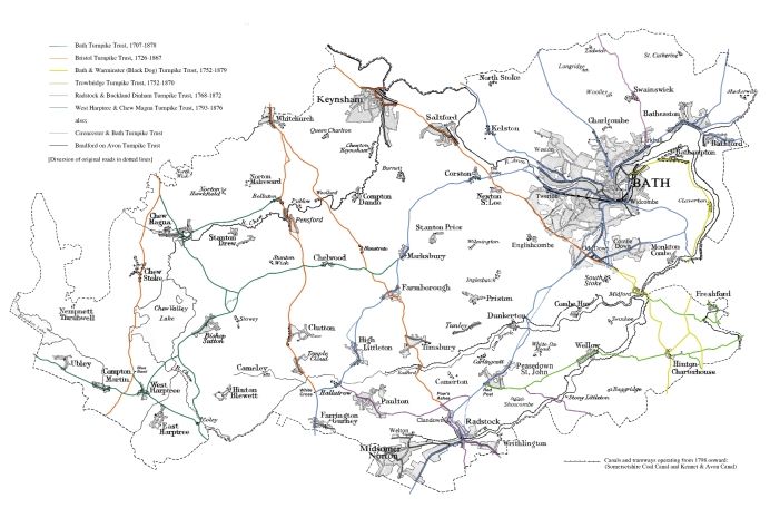
D   Traffic schemes/Environmental improvements

                                                                                     CONTENTS
    Anti-skid surfaces                                                          61
    Cycling                                                                     61
    Pedestrian crossings (formal)                                               61
    Pedestrian crossings (informal)                                             62
    Traffic calming                                                              62
    Traffic management                                                           63

    Appendix 1
    Relevant objectives and public realm actions from the World Heritage Site
    Management Plan                                                             64

    Appendix 2
    Proforma for public realm design statement                                  65

                                                                                        5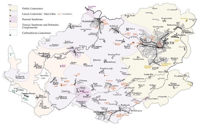
INTRODUCTION

               1 Introduction
                      Background
               1.01   The initiation, production and funding of this Streetscape Manual is the result of a collaborative
                      project between English Heritage, Bath Preservation Trust and Bath and North East Somerset
                      Council.
               1.02   It has been produced by the Streetscape Manual Working Group comprising of Jesca Verdon-
                      Smith (who has since left) and James Ayres from the Bath Preservation Trust, Barbara Selby and
                      Peter Brook form Transportation and Highways, and David McLaughlin and Stephen George
                      (Project Manager) from Planning Services, Bath and North East Somerset Council.
               1.03   This Streetscape Manual provides detailed information that is specific to the local distinctiveness
                      of Bath and North East Somerset. It takes forward the philosophy and principles contained in the
                      ‘Streets for All’ Manual for the South West, produced by English Heritage.

                      Objective
               1.04   The overall objective of this Streetscape Manual is to act as a guide to the selection, design,
                      installation and care of the District’s streetscape and its historic preservation.

                      Aims of the Manual
               1.05   The Manual is intended:
                         To raise the profile of quality streetscape, and to build on and sustain partnerships between all
                         agencies involved in the care and repair of the public realm.
                         To improve clarity by reducing street clutter and duplication in street furniture, signage, etc.
                         To ensure an agreed approach to all aspects of the management, maintenance and design of
                         the District’s streetscape by all the agencies involved.
                         To ensure that the quality of the District’s streetscape is of a high standard, and in Bath,
                         appropriate to its status as a World Heritage Site.
                         To help interpret national guidance to ensure that changes reinforce local distinctiveness and
                         meet World Heritage Site considerations.
                         To meet Objectives 24 and 25 from the World Heritage Site Management Plan. This will help
                         to achieve the associated Public Realm Actions (see Appendix 1).
                         To preserve insitu, maintain to a suitable standard, and enhance the setting of items in the
                         streetscape of historic and architectural value, whether listed or unlisted.
                         To complement other existing standards, guides and best practice (it is not to be read
                         in isolation).

                      Audience
               1.06   This guidance is intended for those designing enhancement or traffic safety schemes, for those
                      implementing works within the public realm including for new developments, for planning and
                      listing building consent applicants and agents, and for those responsible for maintenance and
                      repair. It therefore particularly relates to Officers of Bath and North East Somerset or their
                      representatives, contractors carrying out works, and to the Utility companies working in the area.
                      It is also of relevance to residents, businesses and visitors to the area who are interested in the
                      future presentation and care of the District’s streetscape.
               1.07   The Streetscape Manual was adopted as a Supplementary Planning Document in April 2005 and
                      is supplementary to Policy D2 of the Bath and North East Somerset Local Plan Revised Deposit
                      Draft. It is of particular interest to developers who will be required to implement improvements to
                      the public realm in accordance with the Manual and follow its guidelines in new construction.

    6          Streetscape Manual: Adopted April 2005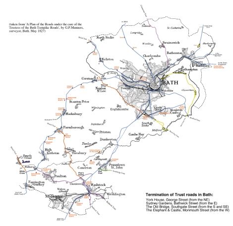
Organisation of Streetscape Manual

                                                                                                                               INTRODUCTION
1.08   The Streetscape Manual is organised into a number of key areas:
          Overarching guidelines that apply to the whole Streetscape Manual.
          Overview of the District’s Streetscape History and Character.
          Specific guidelines covering ground surfaces, street furniture, traffic signs and road markings,
          and traffic schemes / environmental improvements.
          Proforma for the Public Realm Statement.
          Appendix of other reference documents.
          Technical Appendices to the Streetscape Manual which include the Mortar Evaluation, the
          Paving Assessment, and others as and when they emerge. These are available on request.

       Methodology for updating the Streetscape Manual
1.09   There will be an annual review of the Streetscape Manual and the effectiveness of its
       implementation. For clarification of any issues or for highlighting any proposed changes contact
       is to be made with the Senior Urban Designer, Planning Services, who will co-ordinate changes
       and liaise with the Public Realm Liaison Group1 as necessary, and with the Bath Preservation
       Trust if relevant.

       Methodology for using the Streetscape Manual
1.10   The Manual is to be used for all work on the highway whether by the Council or external bodies.
       It is also to be used for all new developments. There is a need to be aware of the available
       resources for the whole project as implementation is dependent on this. The document cannot be
       read in isolation and reference should be made to the documents listed in the Appendix, and
       others as relevant.
1.11   In order to ensure that the Streetscape Manual is properly implemented the Proforma for the
       Public Realm Design Statement included in Appendix 2 could be completed for all schemes. This
       asks questions about the context and provides prompts to ensure that the overarching guidelines
       contained within the Streetscape Manual have been taken on board.
1.12   To ensure that the larger or more sensitive schemes are successful it is important to undertake
       effective consultation with the wide range of stakeholders with an interest in the place, not just the
       issue. To provide clarity and transparency to the decision making process it is suggested that a
       consultation statement is produced that lists all the comments received and the responses made
       to them.

       Sustainability
1.13   During production of the Streetscape Manual and in accordance with government guidance, an
       ‘Appraisal of Sustainability’ was undertaken. This is available as a technical appendix. The
       ‘Appraisal of Sustainability’ included some proposed actions that need to be considered as part
       of the implementation of the Streetscape Manual:
          Consideration is to be given in the procurement process and in the specification for certain
          operations to achieve sustainability objectives.
          Paving materials – the need to consider and appraise whole life costs, sourcing, environmental
          impacts of manufacture and/or extraction when selecting which materials to use.
          The need to consider the sourcing of other materials or goods – eg selecting timber from
          sustainable sources, as well ensuring that materials or goods are manufactured locally where
          possible and if appropriate.

       1 The Public Realm Liaison Group is made up of a group of Officers from across different work areas of the Council who
         meet on a regular basis to discuss and resolve public realm issues that they are involved in.

                                                                                Streetscape Manual: Adopted April 2005             7
OVERVIEW OF DISTRICT’S STREETSCAPE HISTORY AND CHARACTER
2 Overview of the District’s
streetscape history and character
by Mike Chapman
Street Patterns
2.01 At their core, most of the villages and towns in this district still retain their old street patterns laid
down in Saxon or medieval times. Most of these patterns developed organically, and only Bath,
Keynsham, Hinton Blewett and East Harptree acquired planned, rectilinear, layouts. In the ‘urban’
market towns of Bath, Keynsham, Pensford and Chew Magna (and probably in Midsomer
Norton, Queen Charlton and Wellow which held annual fairs), street patterns were further
modified according to their needs as commercial centres. Many settlements grew up on trade
routes, many of which have long fallen out of use, and although the classic village green is not a
feature of this area, a large proportion of the rural settlements are still grouped around a central
triangular ‘green’ at a road junction.
Triangular ‘green’
at Queen Charlton
2.02 In the 18th century further alterations, such as deviations, by-passes, etc, were progressively
introduced to accommodate the development of wheeled vehicles, road technology and new
modes of communication (canals, railways, telegraph, etc.). New streets were created around the
expanding urban communities from the mid 19th century onward, generally on a geometrical
plan (though still adapting to pre-existing features), and in the early 20th century more flexible
but intrusive patterns begin to appear, better suited to the use of motorised road transport.
Street Management
2.03 In the medieval period the maintenance of roads was the responsibility of the governing
landowners, although communities in the towns and villages (assisted by charitable donations)
already had some jurisdiction over market places and other common public areas. However, by
common law, the repair and cleaning of inhabited streets lay entirely with the householder (later
known as the ‘frontager’) who was responsible for the width of his frontage up to the middle of
the street. In Georgian Bath, this practice became statutory under the city Commissioners, and
remained in force until the mid 19th century when street maintenance was taken over by the city
health authority. After 1555, parishes were required by Act to maintain their own Highways
(roads between market towns), but since a large proportion of towns and villages in this area
(nearly a third) stood on main highways, it would seem that most of their streets were already
under parochial management by the late 17th century. These streets were subsequently taken
over in the 18th century by the Turnpike Trusts until the 1870s, when all highways in this area
came under public authority control.
8 Streetscape Manual: Adopted April 2005Figure 1: Characteristic areas of traditional building stone in Bath and North East Somerset
Showing large scale/commercial quarries and limeworks
Streetscape Manual: Adopted April 2005
9
OVERVIEW OF DISTRICT’S STREETSCAPE HISTORY AND CHARACTEROVERVIEW OF DISTRICT’S STREETSCAPE HISTORY AND CHARACTER
Street Frontages
2.04 The actual appearance of inhabited streets in this area changed radically during the late 17th
and early 18th centuries – when stone replaced wood and tile replaced thatch. Changes were
also brought about by the development of road communication in the 18th century. House
frontages in Bath were already being altered for shop windows, post offices and banks by the
1760s, followed elsewhere (displacing traditional markets and fairs) from the mid 19th century.
Although industrialisation was already under way by 1800, with the appearance of purpose-built
‘factories’ and ‘works’ replacing the older workshops, pits, and mills, industrial buildings were
still located away from habitation. However, as urban areas expanded throughout the late 19th
century, particularly in the neighbourhood of Bath and Norton-Radstock, new housing was built
on land adjoining these sites, creating industrial streetscapes. Although most of these heavy
industries have either disappeared or been replaced by lighter businesses, their influence on the
streetscape still remains.
Materials
Local Materials
2.05 The area of Bath and North-East Somerset is located in one of the most diverse geological
regions in the country, providing in the past a wide variety of natural construction materials. As a
result, various subdivisions can be identified in this area, characterised by differences in the local
building stone, as shown on the accompanying map (Figure 1). However, each of these materials
has its own properties, suitable for different purposes, and the divisions on the map are not an
exact reflection of the underlying geological measures. There is also a certain amount of overlap
between these divisions. Although Bath, for example, is now characterised by the famous Oolitic
‘Bath Stone’, a certain proportion of the pre-Georgian city (outlined) was originally built with the
local Lias limestone. This overlap is even more noticeable in the case of road and street
materials. As long as administration remained at a parish level, there was nearly always a
dependency on what was immediately available, but from the 18th century onward use was
made of a much wider variety of materials by larger bodies such as the Turnpike Trusts, which
practically covered the whole area.
2.06 Quarries and limeworks from which these materials were obtained are also shown on the map,
although these represent only the later large-scale or commercial sources, and no account is
taken of the multitude of small local quarries and kilns used for casual and agricultural purposes
over the ages. Similarly, road-stone was often sourced from a temporary quarry, or from the
roadside itself, particularly during the period of the turnpike trusts. Except for the Bath Turnpike
Trust (Figure 3), no documentary records of these seem to have survived.
2.07 The following local materials have been used to some extent in road and street construction:
2.08 Alluvial gravel: Especially the Pleistocene ‘terrace’ gravels found in large quantities along the
Avon Valley, was used extensively for footwalks in the past. The ‘Gravel Walks’ in Bath were an
important asset in the late 17th and early 18th century, before flag-stone paving became
widespread, and gravel ‘pavements’ continued to be used in lesser situations during the 19th
century, particularly in the eastern areas where suitable flat paving stone was not immediately
available.
2.09 Great Oolite Limestone: The famous Bath Freestone, found on the east side of the area. Although
highly valued as a structural material after weathering, it was usually uneconomic for pitching
(see Glossary) and paving, although quarry chippings of the more durable variety were suitable
for common or Macadamised roads.
2.10 Inferior Oolite Limestone: Formerly known as ‘bastard freestone’, commonly occurs in the
‘Cotswold’ country on the north and east side of Bath, although generally in a ‘brashy’ form –
good quality freestone could only be obtained from Dundry Hill on the north-west side of the
area. However, this ‘rag’ stone has provided a low-quality road metal from earliest times, as can
still be seen today in the form of rubble ‘hard-core’ in farmyards, horse-tracking and field lanes.
Although much used in the Cotswold region for pitching and paving, it produces an uneven
surface and irregular appearance.
10 Streetscape Manual: Adopted April 2005Figure 2: Bath Turnpike Trust roads (in blue),
OVERVIEW OF DISTRICT’S STREETSCAPE HISTORY AND CHARACTER
showing roadstone quarries in use in the 1820s
Streetscape Manual: Adopted April 2005 11OVERVIEW OF DISTRICT’S STREETSCAPE HISTORY AND CHARACTER
2.11 Midford Sand: From the Upper Lias series, commonly found in the neighbourhood of Bath.
Although there is little information about its use and extraction, it would have been a useful local
source for mortar and as a bedding for paving slabs.
2.12 Lias Limestone: Blue and White Lias stone – the predominant building material for ordinary
purposes over a large part of the area, except around the Chew Valley and the eastern Cotswold
region. It was also considered to be the best material for ordinary pitching and paving, even in
Georgian Bath, although pennant flagstones were already being introduced by John Wood in the
1740s. It was also an economic material for common or Macadamised road surfacing, and
although criticised in the early 19th century for its friable nature, it was never completely
replaced by the harder Carboniferous Limestone, mentioned below.
2.13 Lias was also a source of a good hydraulic lime, and was the standard bonding for stone setts in
Bath. ‘Perpetual’ limekilns, producing lime on a commercial basis, already began to appear
around Bath in the early 18th century, but were otherwise rare until cheaper coal became
available in the early 19th century. After this time some quite large commercial firms producing
agricultural lime continued in business in this area even as late as the 1980s. Local limekilns
were always sited in or near the quarries from which they were supplied.
2.14 Triassic Sandstone: Sometimes known as ‘New Red Sandstone’ (to be distinguished from the ‘Old
Red Sandstone’ further south, on the summit of the Mendip Hills), this stone mainly occurs in
bands in the Keuper Marl (Mercia Mudstone Group) or ‘Red Ground’ around the Chew Valley.
Because of the thinness of the strata, quarry workings tended to be small and are now difficult to
identify. Also associated with the Keuper Series is the harder Dolomitic Conglomerate, sometimes
found on the south-western side of the Chew Valley, abutting the Mendips. Both of these materials
were used extensively in the buildings around the Chew Valley, giving them their distinctive pink
colour. They were also useful (particularly the latter) as chippings for common or Macadamised
road surfacing, but unsuitable for pitching and paving, and imported Lias or pennant was
generally preferred.
2.15 Pennant Sandstone: A prominent component of the Coal Measures of the North Somerset
Coalfield, there are significant outcrops in the Keuper Marl extending northwards from Temple
Cloud in the south towards Pensford, Brislington and the Kingswood Coalfield. It was highly
prized for its flat, hardwearing surface and smart appearance. Being easily split into large
smooth slabs, it was used everywhere (particularly in Bath) for high-quality paving flags, kerbs
and spurs, with the additional advantage of providing hard chippings for macadamised roads.
From the mid 19th century it was also exclusively used in Bath for pitching the carriageways
(almost completely replacing the use of local Lias), often in the form of ‘bunched’ pennant stone
setts (with ridged surfaces) for use on steep slopes or where a foothold was difficult for horses.
2.16 Coal and Tar: In the early 19th century it was found that coal-ash made a hard mortar or
‘concrete’, which came to replace sand mortar for bedding stone setts. Tar, as a by-product from
the manufacture of gas and coke from local coal, also became commonly available from the mid
19th century, the main supplies in this area coming from the gasworks at Bath, Keynsham, Chew
Magna, Midsomer Norton and Radstock. Asphalt and ‘cinders’ were already being employed for
surfacing footpaths and as a grouting for stone setts by the 1870s. In the early years of the 20th
century Tarmacadam was introduced to overcome the problem of dust and mud created by the
sudden increase in locomotive and motorised transport, although the cheaper method of spraying
tar on Macadamised road surfaces was generally preferred until WWII.
2.17 Carboniferous Limestone: Formerly known as ‘Mountain Limestone’, this stone includes the
sub-groups ‘Black Rock Limestone’, ‘Hotwells Limestone’, and ‘Clifton Down Limestone’ from the
Bristol region which was initially the main source of supply. It is very hard and difficult to work,
and although eminently available in the Mendips on the south-west side of the area, does not
seem to have been much used for pitching or paving. However, in broken form it was found to
be ideal for Macadamised road surfacing, and was progressively introduced from the mid 19th
century onward, particularly on hills, where a tough surface was needed to withstand abrasion
from the locked wheels of loaded wagons. The quarries which were supplying this area at the
end of the 19th century – from the eastern end of the Mendips, and from Wick Rocks to the north
of Bath – have become increasingly important since the stone became a standard component
of Tarmacadam.
12 Streetscape Manual: Adopted April 2005‘Foreign’ Materials
OVERVIEW OF DISTRICT’S STREETSCAPE HISTORY AND CHARACTER
2.18 It is evident, from the large quantities of pennant paving and roofing tiles found on Roman sites
throughout this region, and the widespread number of medieval buildings constructed of Oolitic
freestone, that the transport of local building material over considerable distances was not
unusual even in earliest times. However, the development of canals and railways (together with
improved turnpike roads) considerably reduced the cost of heavy haulage during the first half of
the 19th century, and materials from much further afield could be imported, and in much larger
quantities. From the 1870s onwards, flint, ironstone, basalt, and millstone grit was being ordered
for Macadamised road surfaces, and Scottish and Welsh granite for pitching. It was also about
this time that Bath introduced wood-block pitching onto its streets, consisting of the hard and
rot-resistant eucalyptus Karri or Jarri Wood, which was imported from Australia. This was very
expensive, and was soon superseded by local oak wood treated with chemical preservatives.
Manufactured Materials
2.19 Copper Slag: The earliest and most curious manufactured material to appear on the roads in this
area was copper slag from the numerous brass works which were a familiar feature around the
Avon Valley in the 18th and 19th centuries. Although clinker or slag had always been used for
common road surfacing, copper slag could also be poured into shaped moulds before solidifying
into smooth blocks resembling black engineering brick. This resulted in its use (mainly by the
Bristol Turnpike Trust) for moulded coping stones for roadside walls – still a distinctive feature of
the northern part of the area.
Moulded coping stones on
walls in Corston and Kelston
2.20 Brick: Although brick was used in the area from 1727 onwards, with the opening of the Avon
Navigation, it did not become a common building material in this area until the very end of the
19th century – mostly for industrial and farm structures, but also for decorative purposes. Local
bricks began to be made at Cattybrook in Pucklechurch, with black engineering brick imported
from Staffordshire. Specialised brick was also employed occasionally as a hygienic pitched
surface which could be easily cleaned. This was important in the days of horse transport,
particularly on the streets of Bath, where there were numerous cabstands. It is still frequently
found in the floors of old stables throughout the area.
2.21 Concrete: Concrete in the modern sense, using Portland cement, first appears on the streets of
Bath in 1895 in the form of paving slabs, manufactured at the local ‘Destructor (refuse
incinerator) Works’ from recycled building rubble. By the 1920s concrete kerbs, gutters and posts
were also being introduced throughout the area, and the first concrete road was laid in Bath in
1921. However, except as a WWII austerity measure, concrete road surfacing did not prove to
be a substitute for Tarmacadam.
Streetscape Manual: Adopted April 2005 13OVERVIEW OF DISTRICT’S STREETSCAPE HISTORY AND CHARACTER
Street construction and laying patterns
Construction
2.22 When settlements first began to appear in Saxon times, they were always established around at
least one principal straet – a word inherited from Roman times which implies the presence of a
metalled surface. Even today, almost half of the original towns and villages in this area still retain
early ‘street’ names. By the Middle Ages, Bath had eight named streets, East Harptree had three,
Keynsham, Chew Magna and Midsomer Norton, two (the last two both having a ‘Silver Street’),
the remainder having one – generally called, simply, ‘The Street’.
The Street, Chew Stoke
2.23 Although roads, like footpaths today, were originally only defined as a legal right of passage
and received little structural attention until Norman times, remains of Saxon streets uncovered in
Bath were found to have been laid with some form of metalled surface. Indeed, later examples
from the medieval period consisted of very well-laid limestone ‘cobbles’, mixed with a great deal
of iron-slag for hard wearing. Nevertheless, streets were mainly intended for foot traffic, horses or
livestock, and, since wheeled vehicles were rare, the distinction between a ‘footway’ and a
‘carriageway’ did not yet exist. As a result, the streets of Bath, like many medieval towns, had a
drainage gutter (‘kennel’ or ‘channel’) running down the centre.
2.24 A feature peculiar to this region is the raised footway (often called ‘The Batch’, see Glossary),
running along a terrace beside many of the village streets. These are not pavements in the
modern sense, but separate pitched ‘streets’ or causeways providing pedestrian access to houses
which stood on a steep slope above the main carriageway, a good example being the high
pavements in the High Street of Chew Magna. The term ‘causeway’ is frequently used in the 16th
and 17th centuries, always in the context of improved access or to avoid particular obstacles.
High pavements at Chew Magna and North Stoke (right)
14 Streetscape Manual: Adopted April 20052.25 The appearance of professional ‘paviors’ in the larger towns such as Bath and Bristol from the
OVERVIEW OF DISTRICT’S STREETSCAPE HISTORY AND CHARACTER
late 15th and early 16th centuries onwards show that by that time stone pitching had become a
skilled profession, and that surfaces constructed with regular sized stone ‘setts’ in bonded
patterns was already well established. This method seems to have remained standard until the
20th century, and surviving examples, although built in later periods, are probably little different
from their medieval predecessors. By the end of the 17th century the increase in wheeled traffic
was such that, in Bath at least, footways were already beginning to appear, although originally
these would merely have been pitched with setts on a raised kerb with side drains. The first
footwalks made of flagstones in Bath appear to have been along the front of Terrace Walk, built
in 1705, and within 30 years the city was already famous for its flat public walkways. The Rev
John Penrose wrote on the subject in 1766-67, comparing paving in Bath to a ‘floored room’2.
Initially, the flagstones were of local blue Lias limestone, but by the 1740s the smarter and more
durable pennant sandstone was already being imported along the newly opened Avon
Navigation, and specified by John Wood for paving his Parades.
2.26 However, it was only in Bath and Bristol that street carriageways were pitched with stone setts.
Elsewhere, pitching seems to have been used solely for pedestrian or private use, although side
gutters and covered drains (‘fries’) were common in streets everywhere by the mid 17th century.
However, streets that formed part of a main road, particularly in the small towns, shared in the
improvements introduced by the Turnpike Trusts in the 18th century (Figure 2).
2.27 These included re-grading, widening, better surfacing, and even roadside pavements. Although
the latter were properly pitched, they were of irregular height above the carriageway surface
and often required steps which also served as mounting blocks. By the mid 19th century even the
rural roads had been improved with macadamised stone (see glossary), but footways were still
rare until the late 19th century. Even then, they were generally constructed only on one side of
the street, usually along the fronts of houses whose front doors opened directly onto the road.
House-gardens and areas (usually walled or fenced) were merely provided with a small ‘bridge’
outside the gate over the roadside channel. Such was the success of macadamised road
surfacing, that even the pitched carriageways in Bath and Bristol were being replaced with it,
although this method, known as ‘Steining’, always remained controversial. However, these
practices quickly disappeared after the Great War with the introduction of tar-based surfaces
and concrete.
Laying Patterns
2.28 Although no specification for the pattern of laying stone setts and flagstones along footways ever
seems to have been set down, certain practices can be observed:
1. Pitched stones were always laid so that the bond ran across the line of traffic, giving a better
foothold and avoiding the creation of ruts. This pattern was only interrupted at the entrances to
yards and at the doorsteps of houses, where access was required at right angles to the street. A
similar situation was created by the use of crossings across the carriageway, although many of
these were merely a continuation of a footway across a road junction.
Footway across a junction
in Newton St. Loe
2 See B. Mitchell and H Penrose Letters from Bath (1983) pp 42 and 52, and James Ayres Building the Georgian City (1998)
p.95.
Streetscape Manual: Adopted April 2005 1516
OVERVIEW OF DISTRICT’S STREETSCAPE HISTORY AND CHARACTER
Figure 3: Roads in the Bath and North East Somerset area administered by former turnpike trusts
Streetscape Manual: Adopted April 20052. Two types of pitched footway can be identified:
OVERVIEW OF DISTRICT’S STREETSCAPE HISTORY AND CHARACTER
The ‘Standard’, constructed entirely of pitched setts set between longer kerb-stones. These were
always a feature of the rural areas, the best existing examples being at Newton St.Loe.
Left: Pitched setts
at Newton St. Loe
Right: ‘Improved’
type paving in
Chew Magna
The ‘Improved’ type had a central line of small flagstones, usually of pennant, set between the
standard pitching. These tended to be a feature of the more urban areas, the best existing
examples being in Chew Magna High Street. In one instance, at Twerton, this pattern was also
used for street crossing. Another exceptional example would appear to be ‘Monk’s Walk’ in
Batheaston, a long footway leading from the village out to St.Catherine. This route however was
a popular picturesque walk for ‘respectable people’, and may therefore have been provided as a
leisure amenity.
3. One of the advantages of flagstones was that they not only provided an even surface, but also
had a regular appearance. However it is not clear to what extent pennant and Lias stone flags
were produced at a standard size and proportion like their modern manufactured counterparts. It
would seem that this may have been the case in particular situations like Bath, whereby a
completely regular bond could be provided, but existing examples elsewhere generally consist of
a variety of shapes and sizes. Occasional attempts at patterning can be seen, using alternate
‘long and short’ stones, but this was presumably left to the skill and custom of individual paviors.
No pattern of course was possible using Inferior Oolite which was not squared and therefore
produced a ‘crazy paving’ effect.
Street maintenance
2.29 In the late 1500s, street maintenance in Bath was already a costly affair. There is constant
reference to remaking the pitching in the streets which had been dug up to repair the pipes of the
water supply system, and in 1615 a professional ‘scavenger’ or ‘raker’ was employed to keep
the streets clean. During the 18th century street cleaning developed into a relatively well
organised system, with collection bins and disposal carts. Pavements were repaired and cleaned
by the frontagers and shopkeepers, and by the early 19th century road works were regulated
with hoardings, etc., to reduce the inconvenience to pedestrians. Everywhere else however,
repairs remained simpler, and were dealt with in a more summary manner – the main issue
being the clearance of obstacles (particularly overhanging trees and hedges) and the prevention
of flooding from the drains.
2.30 This situation did not change until the widespread introduction during the 19th century of
improved macadamised road surfaces which could be maintained more regularly and cheaply.
Roads were re-laid by first scarifying the surface with a harrow or plough before spreading the
new material. This was then watered to bind it, and compacted with a horse-drawn roller, a
process which became mechanised in the 1880s by the use of steamrollers with scarifying spikes
and scrapers. Until the introduction of mechanical stonebreaking in the local quarries in the
1890s, a familiar roadside feature was the neat stack of ‘rocks’ situated at strategic points, ready
for relaying or repair, with an elderly man or a boy sat nearby with a hammer, reducing the
stone to its required size.
Streetscape Manual: Adopted April 2005 17OVERVIEW OF DISTRICT’S STREETSCAPE HISTORY AND CHARACTER
2.31 Although organic material and animal droppings were still seen as a valuable manure, and
disposal only a problem on market days, by the 1870s the urban areas already had an
organised service for the removal of ‘road dirt’. A greater problem, common to all stone
surfacing, was the accumulation of dust in the summer and mud in the winter, created by the
constant attrition of iron tyres. Dust was kept down by watering, and Bath already had a
watering service in the early 19th century, including purpose-built watering carts introduced in
the 1850s, but other towns did not follow suit until the 1890s. By this time mechanical sweeping
machines were in use, together with patent mechanical road scrapers for removing mud.
However, in the early 1900s the problem of dust was reaching a crisis point, brought about by
the appearance of fast-moving motor vehicles with pneumatic tyres which no longer compacted
the road surface. The supply of water became stretched, particularly during droughts, and new
methods were investigated, such as the use of hygroscopic calcium chloride and tar spraying.
The latter proved so successful that it was universally adopted from about 1908 until WWII, but
by the end of the war the use of tarmacadam and concrete surfacing had become so well
established that dust no longer remained a problem.
Street furniture
2.32 Although many of the features mentioned here were already familiar in Bath in the 18th century,
most did not appear elsewhere until much later in the 19th century. By this time roads and streets
were already coming under the administration of local authorities who tended to employ
standardised street furniture. However, the region still retained its own character until the
introduction of national statutory standardisation from the 1920s onward.
Traffic management
2.33 Spur-stones. Seated at ground level on the corners of buildings and gateposts, these provided a
protection against the iron tyres and hubs of passing vehicles. Although impossible to date, they
were evidently adopted when wheeled traffic became common during the 18th century. To
withstand wear and tear, they were generally fashioned from pennant sandstone.
2.34 Posts (bollards). To prevent undesirable traffic from entering side passages and, occasionally,
paved walks, posts of wood or cast iron were a common feature in Bath by the late 18th century,
but do not seem to have been extensively used elsewhere. In the 1780s they are described as
being generally 5 feet high, spaced between 2 1/2 to 3 1/2 feet apart. Some, slightly larger, were
hinged to lie flat, and provided with lock and key.
2.35 Railings and Gateposts. In the interests of public safety, a distinctive pattern of cast-iron railing
was adopted by various parishes belonging to the Clutton District Highway Board in the 1860
70s. Good examples remain alongside the streams in the high streets of Midsomer Norton,
Farmborough and Chilcompton, and along the high pavement in Chew Magna. The maker’s
name, sometimes cast into the posts, show that they were supplied from William Evans’ foundry
by the canal basin in Paulton. Evans also supplied the numerous and distinctive round-headed
cast-iron gateposts (generally private) which remain in the streets of Paulton, Midsomer Norton
and elsewhere in that region of the North Somerset Coalfield.
Cast iron railing at Farmborough Historic lantern illustrated by Nattes, 1806
18 Streetscape Manual: Adopted April 20052.36 Street Signs. Finger posts, authorised by Act in 1697, and statutory for the Turnpike Trusts, were
OVERVIEW OF DISTRICT’S STREETSCAPE HISTORY AND CHARACTER
not a common street feature until the late 19th century when cast-iron posts were installed by the
County Council. Many of these have survived, despite being superseded by direction boards or
removed during the invasion emergency in WWII. Milestones, initially of stone but later of cast
iron, became statutory after the introduction of the Turnpike Trusts, and some still remain in those
high streets which formed part of a turnpike road, their distance plates again often removed
during WWII. Warning signs were first introduced during the 1890s as a result of the growing
popularity of cycling, together with the lifting of restrictions on the use of steam traction. A few
early examples have survived, unlike later motor car warnings and speed-limits, gradually
introduced after the Motor Car Act of 1903, which were entirely replaced as a result of
subsequent improvement and standardisation.
2.37 Traffic lights. Although the first traffic lights (vehicle activated) in the West Country were
introduced in Bath in 1933, they did not become a common street feature elsewhere in the
district until much later.
Amenities
2.38 Lamp posts and brackets. Throughout the 18th century in Bath, a system of public street lighting
became well established, using oil or candle lamps – generally supported on wall brackets or on
iron rods attached to any convenient railing. Elsewhere in the district street lamps were only
installed privately, over the entrances of inns, churches, and the larger houses. Public gas
lighting, encouraged by the growth in street shopping, was introduced in Bath in 1818 –
followed after the 1850s by the larger towns such as Midsomer Norton, Radstock and
Keynsham. Although the supply of gas was relatively widespread throughout the region by the
late 19th century, in most of the rural areas the provision of public street lighting was generally
regarded as a luxury and a burden on the rates. However, some villages had a modest street
lighting system, such as Timsbury, which experimented with public lighting by oil lamps for a time
before WWI.
2.39 It was the introduction of gas lighting which seems to have encouraged the development of the
cast-iron lamp-post. Gas-lamp standards and lanterns (frequently supplied by local firms, such as
Stothert and Pitt) varied widely in design, some particularly ornamental examples being erected
for commemorative purposes. In Bath, lamp ‘pillars’ appear to have been painted ‘stone colour’,
with ‘metal colour’ ladder-bars and brackets, suggesting that they were to be regarded (to blend
with the architecture of the city) as classical columns3. Many gas standards seem to have
survived, frequently re-used as garden ornaments, probably as a result of being converted for
electric lamps in the 1920s. Although electric lighting was quickly taken up in Bath (in 1890)
and the larger towns (in the 1920s), most villages in the region remained unlit until well after
WWII. A few early examples of electric lamp-posts may have survived, such as the ‘Swan-neck’
posts in Twerton churchyard.
2.40 Street nameplates. Bath is still distinguished by its street-names carved into the walls of its
Georgian buildings. Fixed nameplates seem to have been introduced in the early 19th century,
but in other urban areas, such as Norton-Radstock, they were not adopted until about 1900.
However many early nameplates seem to survive, there being few reasons to replace them.
2.41 Communications. Post boxes: Most villages had post-offices during the early 19th century, but
post-boxes are not mentioned until the 1870s. These were installed in walls, the earliest mention
of a free-standing pillar box outside Bath being in the High Street, Midsomer Norton in 1901.
Phone booths: The first phone booth appears to have been introduced in Bath, in the High Street,
at the beginning of WWI. This was a large, rather ornate, conical structure, and other early
phone booths at Radstock (1925) and Midsomer Norton (1929) were probably of similar design.
All were removed after the introduction of the standard red box which tended to be sited away
from main urban thoroughfares, but are still a prominent and numerous feature in the villages.
Weigh-bridges: A distinctive octagonal weigh-engine office of classical design was installed in
the middle of the Saw Close, Bath, in the 1760s, and its successor, built in the 1920s, still
remains. Keynsham also had a fine octagonal office, but in gothic style. This stood in the middle
of the junction of High Street, Temple Street and Bath Hill from the 1850s until it was demolished
in the 1930s and replaced with public toilets. Cabmen’s refuges: Only Bath had shelters for
cabmen, one of which, built in 1926, still survives in use at the junction of South Parade and
Manvers Street.
3 M.Beaton, M.Chapman, A.Crutchley and J.Root,
Bath Historical Streetscape Survey, Bath and North East Somerset 2000 Streetscape Manual: Adopted April 2005 19OVERVIEW OF DISTRICT’S STREETSCAPE HISTORY AND CHARACTER
2.42 Health. Drinking fountains: Bath already had public conduits in the Middle Ages (superseded in
the 18th century by a piped water system), but individual wells and springs continued in use
elsewhere until the mid 19th century when the larger landowners began to install piped water
systems to their neighbourhood. Although these were chiefly intended for distribution to farms,
public pumps, hydrants and fountains (some quite ornate) were also provided in the villages. All
these systems have been replaced by mains water, but many of the conduits have been preserved
as an ornamental feature. In contrast, the appearance of ornamental drinking fountains in urban
areas in the late 19th century, particularly in Bath, was either commemorative or a result of the
temperance movement. Water-troughs: Traditionally associated with farms, the appearance of
water troughs on the streets is very much derived from the increasing concern throughout the 19th
century, as transport demands increased, over the misuse of draught animals and the
disappearance of customary watering places. These too, are frequently retained for ornamental
purposes. Public conveniences: Bath was already providing this essential amenity for its visitors in
the 17th century, but public toilets do not appear in other urban centres until the early 20th
century. Some were situated prominently, but most seem to have been sited unobtrusively in
market areas.
Village pump at
Newton St. Loe
Ornamental
2.43 Tree planting and Parks: In Bath, ornamental tree walks were already introduced into the Orange
Grove in the 17th century, and Royal Victoria Park can claim to be the first public recreation area
in the country. In other urban areas however, the planting of trees, initially for commemorative
purposes, does not occur until the end of Queen Victoria’s reign, and avenues of trees for public
enjoyment follow later in the 1930s. The installation of Memorial Seats seem to have followed
the same pattern, reinforced by the universal appearance of War Memorials after WWI. In
several villages single trees were planted at road junctions for some reason, as illustrated by a
petition by Farmborough in 1854 to the commissioner of roads; ‘for permission to enclose a
small portion of ground opposite the Post Office [at the Green] in which to plant an elm tree after
the fashion of Corston and High Littleton’. This tree was indeed planted and grew to maturity,
and in 1920 the top portion, becoming unsafe, was cut out and the timber used at the Pensford
Colliery. It later died as a result of being struck by lightning during a thunderstorm, and the
remains were finally removed in 1948. The well-known ‘Hanging Tree’ which stood in the middle
of Corston disappeared about the same time.
‘Hanging tree’ in Corston
20 Streetscape Manual: Adopted April 2005Glossary to the Overview of the District’s Streetscape History
OVERVIEW OF DISTRICT’S STREETSCAPE HISTORY AND CHARACTER
and Character
Asphalt: The tar and pitch which occurs as a natural geological deposit, particularly in the Middle East.
Also known as ‘bitumen’, ‘mineral’ asphalt, or ‘Jew’s Pitch’ (it is mentioned in the Old Testament). In the
early 19th century the term came to be used for the mixture of tar and sand or grit used for surfacing
footwalks, and occasionally roads. Initially it was generally regarded as unsafe in this country, as it
became very slippery when wet, particularly in a hilly area like Bath. Improvements to this process,
involving the use of crushed ‘natural’, asphaltic, or bituminous limestone, together with the introduction of
the steam roller, led to an increase in its use for roads in the late 19th century. By the 1920s it was
being adopted as a most suitable surface for motor traffic, particularly as a top dressing over
tarmacadam, and remains one of the main road surfacing materials in use today.
‘Batch’: Any raised mound, such as ‘ant-batch’(ant-hill) or ‘pit-batch’ (colliery waste tip), but also for a
rank of houses built on an eminence above a village street.
Brash: Fragmented bedrock lying below soil level.
Bunched Pennant (or batted pennant): (18/19C) Does not occur in the Oxford English Dictionary (OED),
and is apparently a local quarryman’s term for roughly tooled pennant pitching and paving stones
(generally a series of ridges, useful in giving a better foothold); particularly visible on kerbstones.
Calcium Chloride: A salt produced as a principal by-product in the manufacture of soda by the ‘Solvay’
process. It is ‘deliquescent’, that is, has the property of absorbing water vapour from the air, and was
therefore useful for spreading on roads to settle the dust instead of watering.
Cobbles: (19/20C) rounded pebbles used for pitching in coastal regions. Not used inland.
Karri (or Jarri): OED: West-Australian ‘blue gum’ tree (eucalyptus diversicolor) which provided a hard
red timber which did not rot – used extensively in the late 19th century for paving busy carriageways in
Bath to reduce noise of iron tyres on pitched stone surfaces.
Macadamising: (19/20C) road surfacing technique developed by John Louden McAdam (Road Surveyor
for most of the turnpike roads in the Bath and North East Somerset area in the 19th century), consisting
only of small standard-sized stones (2 inch diameter, the width of the average carriage tyre) which had
the effect of compacting under pressure. This produced a flexible (but stable) surface suitable for heavy
goods traffic. Still in use in much of the world today.
Marl: Any geological deposit which has properties halfway between stone and clay, a friable material
which could be broken up and spread over the land as a fertiliser.
‘Blue Marl’ = Liassic marl; ‘Red Marl’ = Triassic (Keuper) marl; ‘Black Marl’= Triassic (‘Tea-green’) marl
Millstone Grit: A hard sandstone found between the coal measures and the carboniferous limestones, as
at Wick Rocks to the north of Bath. Used for making mill-stones and sharpening tools, but also useful as
a macadamised road surfacing which provided a secure foot-hold on steep hills.
Paving: Now refers mainly to the surfacing of walkways with flag-stones, but originally meant any ‘built’
surface, particularly a pitched surface.
Pitching: A ‘built’ street surface made of small squared stone blocks. Laid edge bedded in sand or gravel
(later mortar) in an interlocking pattern in the same fashion as a coursed a stone wall.
Setts: Any small squared stone used for pitching, as opposed to the large flags or slabs used for
walkways.
Steining: An old variation of the word ‘stoning’. Was traditionally a term referring to the stone lining of
wells, but seems to have become adopted in the mid-19th century to refer to the replacement of pitched
surfaces of urban roads with cheaper macadamized stone. This practice was often opposed on the
grounds that it created greater friction on the wheels (particularly when freshly laid) and a poor foothold
– a cruel situation for horses that were loaded for smoother surfaces. It created more mud and dust than
pitching, provided local youths with handy missiles for breaking windows and, because it was quieter,
encouraged lighter vehicles to excessive speeds.
Tarred macadam: The treatment of a macadamised road surface by spraying or laying liquified tar.
Streetscape Manual: Adopted April 2005 21OVERVIEW OF DISTRICT’S STREETSCAPE HISTORY AND CHARACTER
Tarmacadam: The term which first appears in the early 1880s for a road surface material consisting of
small broken (i.e. macadamised) stones in a matrix of tar, sometimes mixed with pitch or creosote, which
is laid over the ballast of the sub-surface and rolled whilst still hot. Said to be first introduced in Sheffield,
it became increasingly popular after the introduction of the pneumatic tyre and, with asphalt, is still one
of the main road surfacing materials in use today. It is a curious coincidence that before he introduced
macadamised surfacing in 1816, J.L.McAdam had already been the owner for 25 years of a coal tar
distillery in Muirkirk called The British Tar Company which produced coke for local ironworks and tar for
the ships. It was his travels between the ports of Plymouth, Bristol and elsewhere which generated his
interest in road building.
Tarmac: Originally the trade name, Tarmac Limited, of a company set up in about 1903 by E.P.Hooley,
then County Surveyor of Nottinghamshire. The company (initially called TarMacadam Syndicate Ltd.)
produced a hard variation of tarmacadam based on a mixture of tar, creosote and iron slag. Within a
few years the name came to provide a handy abbreviation, still used today, for all types of tarmacadam,
and is a generic term for any type of road surface.
Turnpike: a kind of turnstile allowing foot-traffic only. Originally a military device (15-17C), later adopted
by the Turnpike Trusts (18/19C) to control road traffic at toll-gates.
Bibliography to the Overview of the District’s Streetscape
History and Character
James Ayres Building the Georgian City (1998) p.95
M.Beaton, M.Chapman, A.Crutchley and J.Root, Bath Historical Streetscape Survey, Bath and North East
Somerset 2000
M.Beaton, M.Chapman, and J.Root, Radstock and Midsomer Norton Historical Streetscape Survey, Bath
and North East Somerset 2001
P.Davenport, Medieval Bath Uncovered, Tempus 2002
T.Fawcett, Paving, Lighting and Cleansing, n.d circa 1999
T.J.Hunt and R.R.Sellman, Aspects of Somerset History, Somerset County Council, 1973
R.J.Marlor (ed.), A Question of Paulton, Paulton Parish Council, 1990
B. Mitchell and H Penrose Letters from Bath (1983) pp 42 and 52
B.Morland, The Industrial Revolution in Somerset, Somerset Industrial Archaeological Society 1982
V.Packham, Timsbury Parish Council, Timsbury Parish Council 1990
E.Ralph, The Streets of Bristol, Bristol Branch of the Historical Association 1981
E.White (ed.), Keynsham and Saltford, Life and Work in Times Past, 1539 – 1945, Keynsham and
Saltford Local History Society 1990
B.M. Willmott Dobbie, An English Rural Community, Bath University Press, 1969.
22 Streetscape Manual: Adopted April 2005View towards Keynsham Church from the east,
OVERVIEW OF DISTRICT’S STREETSCAPE HISTORY AND CHARACTER
showing weighbridge on the right
Tramway through Batheaston
Brassmills, Keynsham Street and post office, Saltford
Streetscape Manual: Adopted April 2005 23OVERARCHING GUIDELINES
3 Overarching guidelines
Introduction
3.01 The quality of our public space is one of the factors that determine how it is valued by the people
that use it. It helps to influence whether they enjoy being in a particular place, if they want to use
its shops, and whether they care about its future. Quality places encourage greater use, ensure
that they are better looked after by the people that use them, and help to sustain them
economically and socially.
3.02 In achieving quality places there will inevitably be tensions between different issues. There is a
need to balance the Streetscape Manual with other issues in coming up with designs or solutions
to problems. The following will guide works to the District’s streetscape.
Keep it simple, keep it safe.
Question conventional design approaches and consider alternatives.
Consider the wider issues and the cumulative impact.
Consider visual appearance.
Improve accessibility.
Consider sustainability and whole life costs of the materials being selected.
Reinforcing local distinctiveness and improving the image
of the district
3.03 One of the overarching guidelines of the Streetscape Manual is to ensure that the local
distinctiveness of the District is reinforced and that the image of Bath and North East Somerset is
enhanced.
3.04 Local distinctiveness is important for many reasons and is ‘essentially about places and our
relationship with them’.4 For the Streetscape Manual the following reasons are particularly
relevant:
it adds to the character of an area.
it helps to foster pride of place and civic pride.
it gives depth and richness to a place.
it can provide interest because of inherent historical value.
3.05 In relation to the Streetscape Manual the key to reinforcing local distinctiveness is having an
understanding of the character of an area and identifying the important elements of the public
realm that should be preserved, enhanced or which can influence the design of new elements.
The ‘Overview of the District’s Streetscape Character’ above, is an excellent starting point to
appreciate the overall variety in the physical character of the District’s streetscape. This is
supplemented by various other documents that have been produced over the years including the
Bath Historical Streetscape Survey, 1999, and the Radstock and Midsomer Norton Historical
Streetscape Survey, 2000.5 When producing their ‘Parish Plans’, Parish Councils are encouraged
to define their own local distinctiveness and to specify street furniture that helps to reinforce
this character.
4 Local Distinctiveness: Place, Particularity and Identity, Essays for a conference, including papers by: Richard Mabey,
Gillian Darley, Neal Ascherson. Patrick Wright. Michael Dower and Roger Deakin. Common Ground, 1993. See
www.england-in-particular.info/place
5 These documents were commissioned by the Council and were researched, written and produced by Mark Beaton,
Mike Chapman, Andrew Crutchley and Jane Root.
24 Streetscape Manual: Adopted April 2005You can also read