Surprise Valley Barrel Springs - A Self-Guided Tour - Back Country Byway - Bureau of Land ...
←
→
Page content transcription
If your browser does not render page correctly, please read the page content below
U.S. Department of Interior
        Bureau of Land Management

Surprise Valley
Barrel Springs
Back Country Byway

A Self-Guided Tour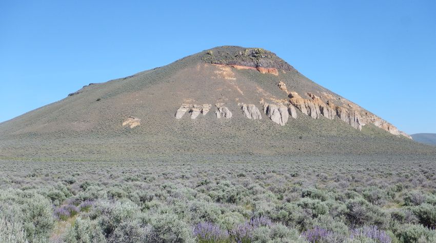
Welcome to the road less traveled! Few people get to
    experience the beautiful mountains and valley you see
    on the front cover. This brochure and map will tell you
    how to find and explore Surprise Valley- how it got its
    name, the history of the emigrants who ventured west
    in 1849, and the geological wonders that have shaped
    this landscape.

        A map showing the location of Cedarville and major highways in the area

    Getting There: From U.S. Hwy. 395 in California, five miles
    north of Alturas, Modoc County, take California Hwy. 299 east
    to Cedarville, California. From Interstate 80 at Wadsworth in
    Nevada, 30 miles east of Reno, take Nevada Hwy. 447 north
    through Gerlach, 141 miles to Cedarville, California.

2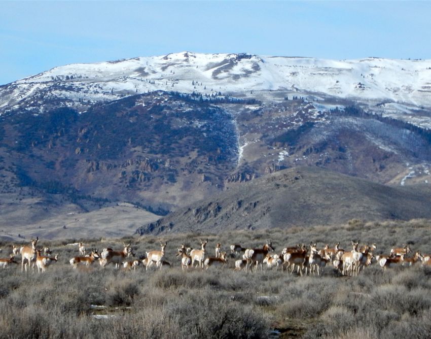
SURPRISE VALLEY-BARREL SPRINGS
        BACK COUNTRY BYWAY
                        A SELF-GUIDED TOUR

Pronghorn antelope with Mount Bidwell in the background

                                                          3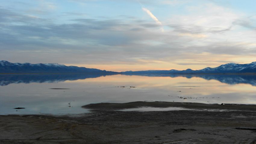
CONTENTS

                1.          THE SECRET VALLEY…...……..1
                2.          BYWAY LOOP MAP……………..10
                3.          BYWAY DRIVING TOUR……....12
                4.          VISITOR TIPS……………………....28
                5.          WILDFLOWER GUIDE…….......30

    Lake City Flouring Mill circa 1900

4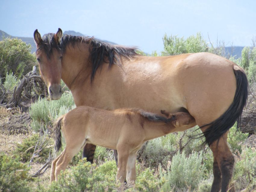
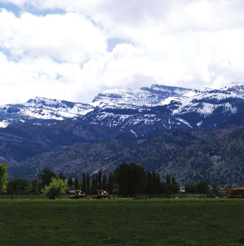
THE SECRET VALLEY

The Warner Mountains soar up from the valley floor like a scene from
an Ansel Adams photograph. In the valley, coveys of quail trickle
across the quiet streets in little towns. At twilight, herds of mule deer
join cattle and sheep in the green fields. There are no stoplights, no
traffic, and no sirens. This is where the paved road ends. This place,
Surprise Valley, is so removed, so distinct from the rest of California,
that you, like others, may come to find that it is the Golden State’s
best kept secret.

QUIET LITTLE TOWNS AT THE EDGE OF THE
WILD WEST

The Byway route through Surprise Valley will take you through a varied
landscape of quiet, small communities nestled at the base of a mountain
range and the high desert filled with sagebrush and juniper trees. As you
travel through this landscape, you are a time traveler in the wild west with
historic buildings and a country that is tough and unyielding.

The Back Country Byway is a great opportunity to experience the “forgotten
California” where hustle and bustle are far away and the landscape
seems unchanged.

                                                                               5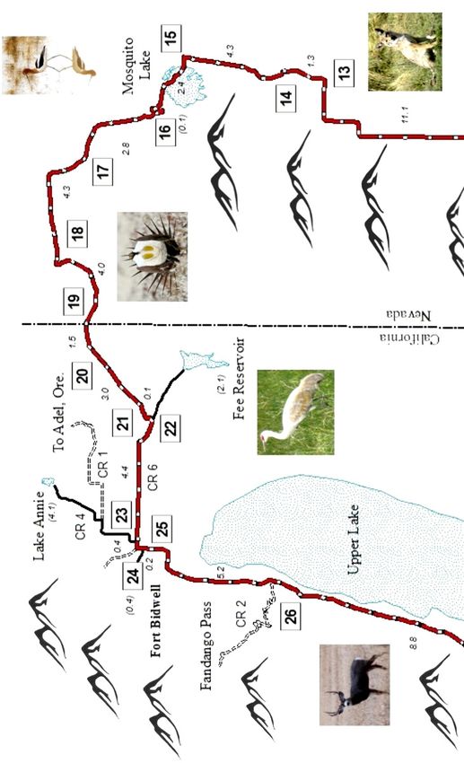
A SENSE OF PLACE

    There are few places on this earth where
    it is possible to travel so quickly from
    one type of ecosystem to another. A
    short drive from Cedar Pass to Surprise
    Valley takes you from alpine peaks and
    pine forests to arid valley floors and
    sagebrush-covered hills. Once you arrive
    in Surprise Valley you enter the world of
    the Great Basin.

    This is a dynamic, ever-changing
    landscape full of challenges. The plants,
    animals, and people that succeed
    here have been able to adapt to arid
    conditions, unpredictable droughts, and
    long, cold winters. It is also a land full of
    beauty and wonder.

    Since people first arrived in the Great         The Milky Way over Long Valley
    Basin, climate and geology have dictated
    where and how they have lived.

    Yet as the landscape continues to change, what will be the effect on us? Or
    has technology removed us from these concerns?

    At the end of your Byway journey you will have a deeper understanding and
    can ponder the question yourself.

    A JOURNEY OF MANY STORIES

    The Bureau of Land Management established Back Country Byways, part of
    the National Scenic Byways network, to provide recreational and educational
    opportunities for visitors who are passionate about taking the road less
    traveled and learning about this places’ natural and cultural history.

    On this journey, you will see evidence of ancient volcanic eruptions, stand
    on a prehistoric beach where people hunted Ice Age animals, re-live a time
    when the U.S. Army Cavalry was stationed at Fort Bidwell, and imagine
    emigrants coming across the rugged landscape in search of a better life.

6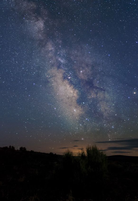
THE HISTORY OF A NAME

Warner Mountains: The Warner Mountains, previously known as the
Warners Range, was named for Captain W. H. Warner of the U.S. Army Corps
of Topographic Engineers, who explored the Sierra Nevada Mountains for
better wagon routes. Captain Warner was killed at the eastern base of the
mountains in 1849.

Surprise Valley: Contrary to local lore (and previous versions of this
booklet), Surprise Valley was not named by pioneers traveling the Applegate
Trail. Alas, if the emigrants had a name for this valley it was never written in
a diary or has been lost to time. The valley was named by Captain Alanson
Nightingill in 1860.

After the Battles of Pyramid Lake, Captain Nightingill and the Truckee
Rangers were in pursuit of Paiute Indians in the Black Rock Desert region. To
their astonishment, they came across the valley which they believe no white
person had ever seen before. Nightingill insisted that they name the area
after their first impression of the valley, Surprise!

Fort Bidwell: This place was originally called Tusi’yamus (“Grassy Corner”)
by the Northern Paiute Indians. The town of Fort Bidwell is named after
General John Bidwell. Camp Bidwell was originally located near Chico,
California. When this camp was abandoned, the name transferred to the U.S.
Army fort at the north end of Surprise Valley.

Lake City: This town was formerly known as Tri-Lake City and named for the
three lakes in the valley. The Northern Paiute called the upward tilting peak
south of town Hu na’-na-mubi (“Badger His Nose”).

Cedarville: The origin of the town’s name is unclear. It may have been
named after Cedarville, Ohio (the hometown of one of Cedarville’s founders)
or after a large cedar tree growing in the canyon above the town. The
Northern Paiute Indians called this place Pa-su-bi (“Water Willow”).

Eagleville: This community south of Cedarville is named after nearby
Eagle Peak. At 9,892 feet above sea level (3,015 meters), Eagle Peak is the
highest point in the Warner Mountains.

                                                                                   7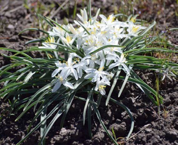
Middle Alkali Lake in Surprise Valley

    A YOUNG AND DYNAMIC LANDSCAPE

    In geological terms, the rugged landscape of Surprise Valley is relatively
    young with its formation beginning approximately 20 million years ago in a
    series of volcanic events associated with basalt (a dark extrusive volcanic
    rock) and rhyolite (a light extrusive volcanic rock) flows.

    After a relatively quiet period of three million years, volcanic activity
    associated with the Yellowstone Caldera flooded the area with more basalt.

    Around this time formation of the Basin and Range increased (and continues
    even today). From Canada to Mexico and from Wyoming to California, the
    land surface is being pulled apart east to west by faults deep within
    the earth. As the earth crust is strained in this way, normal faults develop,
    and blocks of the crust drop down to form valleys. The result is a vast
    landscape of alternating north-south trending valleys and ridges.

    Fifteen million years ago, rhyolitic lava flows and ash flows covered portions
    of northwestern Nevada. Basalt flows then covered the ashfall and the
    extreme pressure and heat “welded” the tuff. Large rivers with forested
    floodplains drained towards the Pacific Ocean.

    These rivers carried nodules of obsidian (volcanic glass) miles downstream,
    and today these rocks are distributed throughout the Massacre Lake and
    Duck Flat basins near Surprise Valley.

8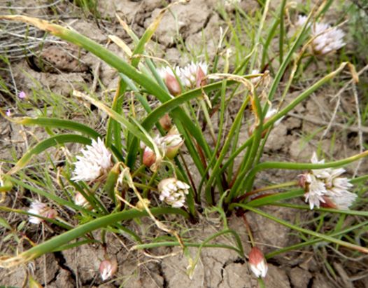
Animals (such as camels, rhinoceroses, three-toed horses, and mastodons)
and plants (such as redwoods and oak trees) flourished between eruptions.

Approximately three million years ago, the Sierra Nevada Mountain Range
and the Warner Mountain Range began to uplift. These uplifts cut off the
flow of the rivers towards the Pacific and today all the precipitation that falls
on this valley never leaves the Great Basin.

The Earth has experienced at least five major ice ages with the most recent
one beginning approximately 2.5 million years ago.

Up until about 20,000 years ago, the northern half of North America was
covered with ice sheets. These sheets of glacial ice were massive with some
almost 2 miles (3 kilometers) thick.

As the Earth’s climate warmed, glaciers began to melt, and large lakes filled
the valley floors throughout the Great Basin. Pleistocene Lake Surprise filled
this valley and Duck Flat basin to the south. The lake was 577 feet (176
meters) deep when it reached its last high stand about 15,000 years ago.

 The basalt-capped layers of volcanic ash and welded tuff at Painted Point

                                                                                    9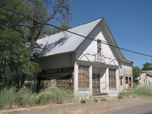
FIRST PEOPLE ON THE SHORES OF LAKE
     SURPRISE

     When people arrived in Surprise Valley more than 10,000 years ago, they
     would have found a 50-mile (80 kilometers) long lake along the edge of the
     Warner Mountains. The hills surrounding Pleistocene Lake Surprise were
     much greener than today and people hunted now-extinct species of camels,
     horses, and bison. Beginning about 5,000 B.C. and lasting for approximately
     2,000 years, the climate warmed considerably and the Great Basin
     experienced a severe drought. During this time, the Great Basin was largely
     uninhabitable except for unique places such as Surprise Valley.

     By 4,500 B.C., people were living along the edges of the present-day lakes
     on the basin floors of Surprise Valley. Around 3,000 B.C. the climate became
     wetter and grasslands expanded across the northern Great Basin. Herds of
     large game increased, and people communally hunted pronghorn antelope
     in large drives.

     Yet, conditions drastically changed. Beginning 1,300 years ago this region
     has experienced decades-long, intermittent droughts. Perhaps due to these
     unpredictable droughts, the introduction of the bow-and-arrow, or the arrival
     of new groups, people abandoned these winter villages and began living in
     different parts of the valley.

     THE NORTHERN PAIUTE OF SURPRISE VALLEY

     The Northern Paiute people are an integral part
     of this community and have been in this valley
     since time immemorial. The traditional territory
     of the Northern Paiute spanned a vast area
     across parts of California, Nevada, Idaho and
     Oregon.

     The Northern Paiute traditional language, Numu,
     is similar to the language spoken by the ancient
     Aztecs of Mexico and the Ute language in Utah.

     The Northern Paiute people of the valley call
     themselves the “Gidutikadu,” meaning the
     groundhog-eaters.

                                                        Yellow-bellied marmot (Marmota
                                                           flaviventris) or “groundhog”

10
The Bidwell area was one of the major winter Paiute campsites. These
hunter-gatherers moved with the seasons to the best sources of food.
In spring, they traveled to the hills in the east to gather food such as biscuit
root, onions, and ya’pa’ roots. In the summer they found game and seeds
available in the mountains and on the volcanic plateaus. Fall was a time
when family groups went into the canyons for berries and wild plums.
The Fort Bidwell Indian Reservation in Fort Bidwell and the Cedarville
Rancheria in Cedarville continue to be the home to many Northern Paiute.
THE BIG EMPTY
Along the emigrant trail, the Great
Basin was known as the “Big Empty.”
Yet, contrary to this characterization,
the region was full of people
whose families had lived there for
generations.
In less than 10 years, the indigenous
American Indians would go from
a rare, sporadic encounter with
a foreigner to witnessing tens of thousands of emigrants crossing their
homeland. Many of the early emigrant trails followed trails created and used
by American Indians.
The emigrants and their livestock depleted the forage along the trails, scared
off wild game that the local tribes depended on, and brought diseases such
as smallpox.
Military records indicate that most attacks by the Northern Paiute against
wagon trains were nocturnal raids that targeted the cattle and horses.
Animals were stolen or wounded to be eaten later. The loss of livestock,
whether from starvation, dehydration, or raids, was no small matter to the
pioneers. Oxen (cattle trained to pull wagons) were vital to the emigrant
families.
Once they reached their destination, the families relied on milk from the
cattle to make butter, cheese and other dairy products that were hard to
come by on rural homesteads. On the trail, these animals pulled the wagon
which carried families’ belongings. Without livestock, people would have to
begin their new life with only the items they could carry on their backs.
11EARLY HOMESTEADING IN SURPRISE
Emigrants traveling the Applegate-Lassen trail passed through Surprise
Valley in the 1840s and 1850s on their way to California and Oregon.
As available land in the west
became scarce, people began
heading east and homesteading
in the rural areas of northeastern
California and southeastern
Oregon.
Due to a drought in the
Sacramento Valley, a number of
people came to Surprise Valley to
homestead in the early 1860s.
The earliest settlers
homesteaded at the northern end
of the valley on the winter villages
of the Northern Paiute. By 1865
there were about 300 settlers
throughout the valley.
As tension between the settlers
and the Northern Paiute
increased, the settlers petitioned
Unidentified man with dog in Surprise Valley the government to send Army
circa 1885
troops for protection. A military
fort was established and named
in honor of U.S. Representative John Bidwell from Sacramento, California.
In 1866, 105 Army soldiers were stationed at Fort Bidwell and conflicts with
local tribes ended in Paiute and pioneer casualties.
Townsend Street in Cedarville is named for the pioneer settler James
Townsend who was killed in one of these battles. In 1892, the Army
presence was no longer needed and the buildings were turned into a
regional Indian school and hospital.
The communities of Fort Bidwell, Lake City, Cedarville, and Eagleville that
sprung up in the valley in the 1860’s were outposts in the wilderness.
Because of their distance from the cities in California (freight wagons took 17
days for the round trip to Redding), people in the valley were self-sufficient.
They produced their own lumber using steam sawmills, and flour from water-
powered mills such as the Lake City Flour Mill.
12Merchants not only sold goods, but served as buyers and the valley’s
bankers. The residents established schools, hospitals, fire protection, and
law enforcement.
Surprise Valley today is “hay ranching” country. Ranchers winter their
cattle on valley pastures. In mid-April “buckaroos” move the cattle onto
public rangelands managed by the BLM Applegate Field Office in northeast
California and northwest Nevada.
Combine harvester and thresher in Surprise Valley circa 1895
In September and October, the “gathering” takes place when cattle are taken
from the range and returned to their home ranches in and around Surprise
Valley. While some cattle are transported in trucks and trailers, others return
home on traditional cattle drives- ranchers on horseback guide the livestock
along roads (including the Byway) to their winter pasture.
13BYWAY DRIVING TOUR
The Byway tour is a 90-mile loop that begins
and ends in Cedarville. Allow a minimum of
three hours for the tour. Take your time and BYWAY
enjoy the peace and quiet. Points of interest are TOUR SITE
numbered in order on the route starting to the
east (CA Highway 299).
An equally enjoyable journey can be made by
starting out of Cedarville to the north on County
1
Road 1 and following the points of interest in reverse order. The
figures in parenthesis indicate the distance between the points of
interest. The mileage begins at the junction of CA Highway 299 and
County Road 1 in Cedarville (at the four-way stop). Cell phone service
typically ends at the California-Nevada state line.
1. THE BIG SLIDE
(0.4) On the highway east of
Cedarville look directly above the
road at the mountain on the east side
of the valley where you can see the
results of a massive earthquake.
At the top of the ridge is a sheer
cliff in a semi-circle shape. The cliff appears steeper and sharper because
it is newer and has experienced less erosion. Below the cliff, the collapsed
hillside descends to the base of the mountain.
The slide is more than 10,000 years old and resulted when a jarring
earthquake forced a 15-foot uplift of the ridge.
162. ALKALI LAKES
(2.0) Surprise Valley is occupied by a series of alkaline lakes- Lower, Middle,
and Upper Alkali Lakes.
The combined surface area of the lakes is approximately 85 square miles
(220 square kilometers).
The lake beds are typically flooded with shallow water during the winter and
spring, but dry up during most summers.
Although the water is not potable for humans, the lakes are habitat for fairy
brine shrimp and migratory birds.
3. MIDDLE LAKE AND THE BISON HUNTERS
(1.3) After you pass the east shoreline of the lakebed, take a
closer look at the landscape. You will see sand dunes, salt grass flats, and
bushes growing on the tops of little mounds of soil. It may look like an arid
desert, but 6,000 years ago the lake had plentiful water and there were
freshwater marshes along the east shore.
Archaeological excavations in Surprise
Valley have discovered prehistoric villages
that existed here before the first cities and
civilizations in the Middle East.
The people who lived here built large
semi-subterranean lodges with walls and
roofs of woven mats supported by a wooden
framework. A central hearth was surrounded by sturdy posts 6-8 feet high
with the top and sides covered with soil for insulation.
People returned to these winter villages repeatedly for thousands of years.
Archaeological evidence revealed that these people ate a variety of food.
They hunted large game such as bighorn sheep, deer, antelope, and bison,
small game such as jackrabbits and cottontail rabbits, and waterfowl. Edible
roots and seeds were also eaten.
Approximately 700 years ago, for reasons unknown, most of these villages
were abandoned and people moved elsewhere on the valley floor.
174. HOT SPRINGS AND FAULTS
(0.5) Both sides of the valley have earthquake faults and you are passing
over one now. The faults have deep shafts hundreds of yards wide formed
of crushed and ground rock where water can flow through. When the water
reaches the deep hot layers of rock it is heated and surges back to the
surface as hot springs.
On cold mornings steam from these hot springs forms a thick cloud that
spreads out for a mile like a giant flat mushroom. There are seven hot
springs throughout Surprise Valley.
5. LIVING IN A RAIN SHADOW
(3.5) This is an ideal location to see the effects of a rain shadow. Most of the
storms that provide rain and snow to Surprise Valley come from the Pacific
Ocean. As these storms move west they are blocked by the tall Warner
Mountains. Consequently, the west side of the mountains receive twice as
much precipitation than the eastern slopes.
The rain shadow effect is so severe along this side of the valley that even
a gain in elevation does not change it.
Although the Hayes Range is more than
7,500 feet high it lacks the evergreen
forest that cover the slopes of the Warner
Mountains.
As a result, plants and animals living east
of the Warner Mountains have adapted to
survive in arid conditions.
6. SOARING HIGH ABOVE
(1.3) The abundance of food in Surprise Valley supports a large population of
eagles, hawks, and falcons.
Eagles are North America’s largest birds of prey
and are twice the size of hawks. Golden eagles
nest in canyons and cliffs, including those in front
of you. Mature bald eagles can be recognized
by their white head which gives them a “bald”
appearance. While bald eagles do not nest
These sagebrush uplands are also important
hunting grounds for golden eagles and
prairie falcons. Bald eagle
18The brownfeathered eagles are twice the size of
hawks and nest in the cliffs you see in front of
you and to the north.
The open ground between bushes helps them
hunt for rabbits and rodents for their young.
If you see a falcon cruising you may want to stop
and watch, for the power dive of the falcon onto
its prey is one of nature’s memorable moments.
7. GRAZING ON PUBLIC LANDS
Golden eagle
(1.7) Since the arrival of emigrants in the
mid-1800s, livestock grazing has been an integral part of public lands.
Prior to the 1934 Taylor Grazing Act, there were conflicts between ranchers
across the West (such as the Sheep and Cattle Wars in the late 1800s and
early 1900s) regarding who could graze public lands.
Overgrazing depleted forage and caused severe erosion along streams
across the West.
Congress passed the Taylor Grazing Act to regulate livestock grazing on
public lands to improve rangeland conditions. Today, the BLM Applegate
Field Office manages 201 livestock grazing allotments in multiple counties in
northeastern California and northwestern Nevada.
These allotments are divided into pastures which are used to manage where
and when cattle and sheep graze. The terms and conditions for grazing
on public lands are set forth in permits issued by the BLM to public land
ranchers.
198. WILD HORSES
(2.8) A small herd of wild horses from the Carter Reservoir Herd lives along
this part of the Byway. The horses winter within a couple of miles of the
Byway and move north into higher country during the summer. The herd is
isolated from other horses to the east and south.
The BLM is responsible for
managing the herd and
sees it as an opportunity
to preserve and foster
the primitive color and
markings of the original
Spanish barb horses.
The distinctive
characteristics include a
dark stripe along the spine
and zebra-like stripes on
the legs.
Periodically, excess horses
Wild horses from the Carter Reservoir herd
are gathered and offered
for adoption. Contact any
BLM office for adoption information.
9. REDWOODS AND MAPLES
(1.2) Before the mountains of the Coast Range, Sierra Nevada, and Warners
uplifted, there were lowland hills from here to the Pacific Ocean. About 11
million years ago the warmer and wetter hills were covered with lush forests
of sequoias and maple trees. To the north of the road are areas with petrified
wood and leaf fossils.
The leaves are located in a band of
white ashy earth which can be seen
from the Byway near the top of a
nearby hill (about a third of a mile
from the road). The wood is further
to the northeast and can be found by
following the jeep trail north to where
it ends on the top of a knoll. Look on
the east side of the knoll, near the top.
Fossil leaves
2010. CANYON OF THE 49ERS
(0.3) You are now on the Applegate-
Lassen Trail, one of the routes of the
1849 California gold rush. Pioneers
often used axle grease to sign rocks
with their initials or the year they
passed through. For example, the
first “49” marking on Fortynine Rock
is said to have been put on with
wagon axle grease. For the pioneers,
this rock marked Fortynine Camp
and was the last place to camp with
good water before crossing the dry
Henry Lind’s 1941 photo of 49 Rock basin floor of Surprise Valley.
11. 49 LAKE
(4.5) Weeks before
the emigrants reached
this area, their
journals depicted a
“dismal, horrible, and
hellish” experience.
They had crossed the
Black Rock Desert
from the “Humbug”
River (Humboldt)
and traveled through
rugged canyons.
Months had passed since the pioneers left Missouri civilization and many of
the emigrants were struggling. The weary 49ers came straight west across
the valley and Fortynine Lake below you. In late summer and fall the lake
was normally dry, cattle had died or were weak, people were tired or ill, and
belongings had been abandoned. By the time they reached this valley they
knew the meaning of suffering along the emigrant trail. An estimated 1 in 17
perished on the journey. The first view of the mountains of California was
eagerly anticipated.
2112. THE MYSTERY OF THE MASSACRE RIM
(5.3) Unlike Egyptian hieroglyphs, the meaning of prehistoric American Indian
pictographs (painted rock art) and petroglyphs (carved rock art) remains
unknown.
Some experts believe that the images may relate to historical events, cultural
heroes, or visions experienced by shamans. Across the valley to the east you
can see Massacre Rim. On the mountain is one of the Great Basin’s most
mysterious petroglyphs, a seven-foot-long fish!
Most of the top of Massacre Rim is a BLM Wilderness Study Area (WSA).
The BLM will manage it for conservation until Congress determines whether
it qualifies as wilderness. The 101,290-acre area is one of 60 WSA’s in
Nevada. Keep an eye out- you may see California bighorn sheep on the steep
escarpment of Massacre Rim!
13. JOHN C. FREMONT, EXPLORER
(11.1) The Fremont exploration and mapping expedition came through here
between Christmas and New Years in 1843. Fremont wrote in his journal that
he had seen few people except for the small band of Paiute men, women
and children on a well used Native American trail south of Oregon.
He noted that they reacted as if they had never seen white people.
Fremont’s expedition to this area ended in 1846, when he departed for the
Sonoma region to support the Bear Flag Revolt, an insurrection of American
settlers challenging Mexican authorities. The revolt was instrumental in
California becoming a state in 1850.
2214. WE ARE GRITTY AND BRIGHT
(1.3) The theme of unfulfilled dreams is
repeated historically throughout the West. Gone
are more than 40 families who homesteaded
here in Long and Mosquito valleys, and three
schools in Vya and Beulah.
Homesteading on federal land had four major
peak periods in American history with the last
occurring from 1901 to 1921.
The Enlarged Homestead Act of 1909 increased
the amount of land homesteaders could claim
from 160 acres to 320 acres. In 1910 more
land was homesteaded than in any year in
American history.
For about a decade there was adequate rain for
crops in Long Valley and the spirit of the people
is reflected in the following letter:
“We are starting out new in Long Valley, but we are brave.
We are gritty and bright. We also are true to our valley. We
know you would see a good sight if you rode through the
sagebrush desert of a short five years ago, and see the
grain and grasses that are now ready for the mower. The
gardens, the fruit and chickens, the horses and pigs and
the cows, the rich loamy soil is now all cleared and ready
for the plows. Oh, we’re not asleep nor absent but though
we are slow, we are wise and ask you to sit up and take
notice, we are not far behind Surprise”
… Newspaper letter, dated July 22, 1914
2315. MIGRATION REST STOP
(4.3) As you drive on the levee over Mosquito
Lake, you may see water in the spring and early
summer.
Intermittent lakes are lifesavers for migrating birds
because there is plenty of food and predators are
deterred by the water and mud. Sneaking up on
sleeping birds at night is nearly impossible.
Mosquito Lake is particularly popular
with shore birds that are characterized by
their long legs, pointed and sometimes
curved beaks.
If a flock of birds flies by you displaying a
striking black and white pattern you are
looking at a flock of willets.
16. BASIN AND RANGE
(2.4) You are standing on the edge of a rising block fault. The block fault is
lined by valleys, Surprise Valley along the western edge and Mosquito Valley
and Long Valley along the eastern edge.
The cliffs to the east near Massacre Rim clearly mark an uplifting block of
land. This repetition of black faults (ranges) and valleys (basins) repeats
from the Warner Mountains all the way to the Rocky Mountains.
You can also see how the environment changes with elevation. There is little
moisture on the basin floors, so the valleys are covered with drought-tolerant
plants. As elevation increases on the surrounding uplands, springs fed by the
melted winter snowpack provide water even in the late summer. Distinctive
communities of plants and trees grow on these uplands and are not seen
again for miles. The Great Basin has been described as mountain islands
surrounded by an ocean of sagebrush. This unique landscape has evolved
over thousands of years.
A short (0.1 mile) drive or walk down the dirt road to the southeast provides
a lovely view of Mosquito Lake and the mountains beyond.
2417. ASPENS AND FAWNS
(2.8) You know there IS water when you see a grove of aspen trees. Just like
an oasis, the trees serve as critical habitat for wildlife, providing food and
shelter from predators and an ideal place for mule deer to give birth to their
offspring.
In late summer the deer take their young up the mountain to feast on the
late-growing young leaves.
18. WILD GARDENS
(4.3) More than 80 edible roots and tubers were used
by American Indians in the West at the time Euro-
American settlers arrived.
Like “wild gardens,” these plants were managed by
American Indians over long periods of time by means of
burning, selective harvesting, tilling and weeding.
Fields of ya’pa’ (Perideridia species) can be seen on top
of volcanic plateaus as they are well suited to rocky, thin
clay soils.
The Northern Paiute gathered large quantities of these
roots in the spring and summer which were eaten raw,
boiled, or dried in the sun and stored for the winter.
2519. STRUTTING AND BOOMING
(4.0) The sagebrush uplands are important breeding and brood rearing
habitat for the Greater Sage-Grouse.
These chicken-sized birds breed in areas called “leks” with breeding displays
of strutting males vying for the females’ attention.
The males also produce a booming noise with their vocal sacs which can
be heard from miles away. If you see strutting birds, it is best to stay several
hundred yards away so as not to disturb them. In spring, the hens nest in
dense sagebrush to protect their young from predators.
During winter sage grouse live amongst the taller sagebrush where they
primarily eat sagebrush leaves.
The BLM is committed to maintaining and improving the diverse vegetation
that the sage grouse depend upon.
20. WHERE THE DEER AND THE ANTELOPE PLAY
(1.5) Despite the name, pronghorn antelope are more closely related to
giraffes than antelope.
They are the fastest native land animal in North America and can run up
to 65 miles per hour (105 km/h). They evolved to be this fast to outrun the
American cheetah (now extinct).
The sagebrush-covered plateaus are important
habitat for pronghorn. Sagebrush and forbs
such as blue mustard, buckwheat, and yarrow
are rich in protein. The brush is low enough that
the antelope can see predators and feel safe
enough to birth their kids in early May.
Mule deer
Antelope
The white patches on the belly and the neck
distinguishes the antelope from the mule deer.
2621. LAKE SURPRISE BEACH
(3.0) Imagine the first humans to see Surprise Valley walking over this spot
and looking at the huge lake in front of them with the high mountains in the
backdrop.
More than 10,000 years ago Lake Surprise was filled by rainfall and melting
glaciers from the mountains, making the entire valley in front of you full of
water. It was a cooler, temperate time and the hillsides were full of grasses,
wildflowers, and evergreen trees.
These people lived during the Ice Age when hairy mammoths, camels,
horses, giant bison, musk ox, and sabre-tooth cats roamed this land. If you
look closely at the hills you can see the terraces that represent the old
lake levels.
22. FEE RESERVOIR
(0.1) Two miles to the east is a small
campground with water, restrooms and a
boat ramp. Fishing is subject to change
depending on water and weather conditions.
23. LAKE ANNIE
(4.4) Lake Annie is five miles north from this junction on a passable gravel
road. The lake was once a bay on Pleistocene Lake Surprise. It is the only
freshwater part of the ancient lake that survived. Fishing is permitted.
2724. FORT BIDWELL CEMETERY
(0.4) Camp Bidwell was a hastily erected U. S. Cavalry post built in 1863
after Surprise Valley settlers petitioned the government for protection from
the Paiute Indians.
Life at the fort was
challenging. In the beginning,
the majority of the enlisted
men were 23 years old or
younger. Desertions were
common; small groups left
and seldom returned.
A few days after Christmas in
1877, Sgt. Frank Lewis took
his life on the steps of the Bidwell store in front of his men. The troops raised
money to construct a tombstone with an inscription commemorating
Sgt. Lewis.
The monument is in the cavalry section of Fort Bidwell cemetery that you
can visit. The inscription reads, “This monument was erected by his company
comrades as a testimonial of their love for one who was a universal favorite
with all who knew him.” He was thirty years old.
Officers’ Quarters at Fort Bidwell circa 1875.
28Kober’s Drygoods Store in Fort Bidwell circa 1908 (above) and in 2016 (top left)
25. FORT BIDWELL TOWN
(0.2) Historic buildings such as the Fort Bidwell Hotel, Kober’s Drygoods
(pictured above) and the community church still look as they did over 100
years ago.
In the back of Kober’s you can find out who was buried before the turn of the
20th century by reading the inscriptions on the wall.
The wall served as the town’s original cemetery record and most of the
names are faintly legible. The Fort Bidwell General Store was one of
California’s oldest stores in continuous operation.
In order to be fire-proof, it was constructed from stone and when it was built
in 1874 this was truly an outpost in the Wild West.
The last time the General Store sold gas it cost 89 cents per gallon.
2926. FANDANGO PASS
(5.2) In 1846, the Applegate brothers led their first wagon train across
the Applegate Trail and over this pass through the Warner Mountains. The
Applegate Trail was established as an alternative to the more dangerous
Oregon Trail which required pioneers to float their wagons down the
treacherous Columbia River.
This pass was originally
referred to as Lassen’s
Pass by the pioneers and
renamed Fandango Pass in
the 1870s. Fandango refers
to a popular 19th century
dance. It only takes a few
minutes to drive to the top
where you can experience a
breathtaking view.
History buffs may want to search for wagon ruts where the pioneers hitched
multiple teams to a wagon to climb the steep hillside.
More than one wagon broke free to go crashing back down the mountain.
The rock retaining wall on the hillside just before the Forest Service sign was
built for the military road to Fort Bidwell.
On the west side of Fandango Pass is Goose Lake where in 1848 Peter
Lassen created his famous “short cut” to the central valley of California
called the Lassen Trail.
Applegate Emigrant trail over Fandango Pass in 1941
3027. MUD VOLCANO
(8.8) In 1951, approximately 300,000 tons of mud and water erupted from
the hot springs midway between the road and the lakebed below you. Mud
particles were thrown about a mile into the air and pea-sized pellets landed
as far as four miles away.
The event created 15-foot tall mud cones which have since eroded away and
are now covered with grass.
You can still see some of the small ponds in the hot water marsh. Like other
hot water sources in the valley, the water can be boiling or near-boiling and
extreme care should be taken when exploring hot springs.
28. LAKE CITY
(1.8) Lake City was once the largest town
in Modoc County. It was first settled in
1865, and by 1868 the town included
a gristmill, hotel, saloons, and a post
office. Idaho traffic greatly influenced the
early growth of towns in Surprise Valley
as it was located along the mail route
between Susanville, California and Boise,
Idaho. Lake City was also considered the
halfway point between the Sacramento
Valley and Owyhee mines in Idaho. The
1870 Lake City Flour Mill can still be
seen on South Water Street.
29. CEDARVILLE
(9.6) Cedarville was founded in 1864
and was originally known as Deep Creek.
The Center Street Park is an ideal place
for picnicking and relaxing. You can
see the Townsend Cabin, the first cabin
built in Cedarville and which was later
operated as a trading post by William T.
Cressler and John H. Bonner. Cressler
and Bonner built a much larger two-story
store in 1874 that still dominates the
west side of Main Street.
31TOURIST SERVICES INFORMATION
SERVICES
Cedarville
Gasoline, Hardware Store, Grocery Store, Lodging, RV Camping, Restaurants,
Hospital and Walk-in Clinic
Fort Bidwell
Lodging, Restaurant
RESTROOMS
Cedarville Park, Fee Reservoir Campground
For more information: Contact the BLM office in
Cedarville, 602 Cressler, just off California Highway 299
and clearly signed.
Telephone: (530) 279-6101.
Monday-Friday 7:45 a.m. – 4:30 p.m.
32CAMPGROUNDS
Fee Reservoir Campground along the Byway. Stough Reservoir (a Forest
Service campground) on California Highway 299 on Cedar Pass. Camping is
also permitted on the BLM land along the Byway.
ALONG THE BYWAY
Outside of the towns listed on the opposite page, there are no services of any
kind. There is typically no cell phone service east of the California-Nevada
state line.
IMPORTANT SAFETY TIPS FOR
AN ENJOYABLE TRIP
Before leaving Cedarville, check your gas
level, air pressure in your spare tire, and tire
changing equipment.
Do you have at least a gallon of water to drink
in case you have mechanical problems and have
to wait for someone to come along? If you have
mechanical problems, raise the hood and trunk
cover as a signal for help and wait in your vehicle.
If there has been a snowstorm or a big
rainstorm, check in Cedarville about road
conditions before you leave the valley. Unseasonal
snowstorms may occur in May and October.
The road west out of Mosquito Valley is
narrow and fairly steep and not recommended
for long trailers and long motor homes. There are
two improved creek bed crossings on the Barrel
Springs road where the presence of rocks may
be a hazard for vehicles with very low clearance.
When in doubt, stop, get out and assess the road
segment in question.
33WILDFLOWERS YOU MAY SEE ALONG THE WAY
Wild Onions (Allium) : Found near
sagebrush and have an unmistakable
garlic-like aroma when crushed. The pink to
purple flowers appear in April as a ball-like
cluster at the tip of the stem.
Lupines (Lupinus) : These members of the
pea family grow from 2-2 1/2 feet tall. Blooms
in May and June with purple and blue the most
common colors.
Sand Lily (Leucocrinum montanum) :
A short, 6-inch, beautiful and sweet-
scented herb with white flowers of six
petals. Blooms in April and May.
Rabbitbrush (Ericameria nauseosa) :
A widespread twiggy shrub with narrow,
long, silver-haired leaves. Its golden flowers
are a feature of late summer. The yellow
flowers of sagebrush also bloom in the fall.
34We need your help to protect our archaeological and
historic sites.
Taking arrowheads and other historic objects is against
the law and severely punished. But more importantly,
the loss or disturbance may destroy the opportunity to
make a scientific breakthrough in our understanding of
the past.
If you discover an artifact, leave it in place, note its location, and notify the
nearest BLM or other Federal office.
We have produced this
brochure for your enjoyment
and would like to hear from
you about your experience on
the Byway.
Also, if you have any
suggestions on how to improve
the Byway or this brochure, let
us know at the BLM office in
Cedarville.
Surprise Field Station
602 Cressler Street
Cedarville, CA 96104
(530) 279-6101
Surprise Valley-Barrel Springs Byway
35Bureau of Land Management Bureau of Land Management
Surprise Field Station Applegate Field Office
602 Cressler Street 708 W 12th Street
Cedarville, CA 96104 Alturas, California 96101
(530) 279-6101 (530) 233-4666
www.blm.gov/California
Historical photos courtesy of the California State University, Chico, Meriam
Library Special Collections; Greater Sage-Grouse photo courtesy of Philip
Knorr; Surprise Valley-Barrel Springs Byway photo courtesy of Laurie Sada;
Milky Way photo courtesy of Richie Bednarski; wild horse photo courtesy of
Rebecca Carter; contemporary photo of Kober’s Store by Claude Singleton;
fossil leaf photo courtesy of Jennifer Mueller.
BLM/CA-GI/2017/011+8600+8357+8303/Rev 2020You can also read