Te Ara Tupua Ngā Ūranga ki Pito-One Cultural & Environmental Design Framework (CEDF) - NZ EPA

Page created by Jamie Barber
 
CONTINUE READING
Te Ara Tupua Ngā Ūranga ki Pito-One Cultural & Environmental Design Framework (CEDF) - NZ EPA
Te Ara Tupua                                       22 September
                                                   2020
                                                   —
Ngā Ūranga ki Pito-One
Cultural & Environmental Design Framework (CEDF)

FINAL (planning version)
Te Ara Tupua Ngā Ūranga ki Pito-One Cultural & Environmental Design Framework (CEDF) - NZ EPA
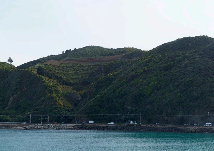
Disclaimer

This report has been prepared in support of the notices of requirement
and applications for resource consent for the Project made by Waka
Kotahi under the COVID-19 Recovery (Fast-track Consenting) Act
2020 (COVID-19 Recovery Act). In particular, this report supports the
assessment of the Project's effects on the environment as required by the
COVID-19 Recovery Act. The requirements of the COVID-19 Recovery Act
and an overall assessment of the effects of the Project on the environment
are set out in the Assessment of Effects on the Environment.

This report has been prepared by Isthmus Group Ltd for the benefit of
Waka Kotahi - NZ Transport Agency. No liability is accepted by Isthmus
Group Ltd or any employee of or sub-consultant to Isthmus Group Ltd with
respect to its use by any other person.

This disclaimer shall apply notwithstanding that the report may be made
available to other persons for an application for permission or approval or
to fulfil a legal requirement.

Author: Lisa Rimmer, Landscape Architect and Urban Design, Isthmus
Mana Whenua Advisors: Morrie Love, Kara Dentice and the Mana
Whenua Steering Group
Cultural Expression Artist: Len Hetet
Design and Production: Chelsea Kershaw, Kadin Hegglun, Zach Barker,
James Pattullo, Tessa Macphail, Blair Brixton, Sean Burke and Lisa
Rimmer Landscape Architects, Jia Ying Hew, Gabrielle Free, Jason
Barnes , Scott McKerrow and Andrew Mirrams Architects, Isthmus

Graphics, photographs and maps by Isthmus unless otherwise stated

Cultural Expression Artwork: Len Hetet
Tupua, Ngāke and Whātaitai - Cover Image
Te Ara Tupua - Page Banner

JOB ref: 4244
©Isthmus Group Ltd 2020

Document record
Issue          Revision       Author      Date

Draft          A              LR          06/03/2020
Advanced       B              LR          25/05/2020
Draft
Final Draft    C              LR          20/07/2020
Final          D              LR          02/09/2020
Final          E              LR          09/09/2020
Final          F              LR          18/09/2020
Final          G              LR          22/09/2020

2                                                                             Te Ara Tupua - Ngā Ūranga ki Pito-One CEDF | Waka Kotahi | September 22, 2020
Te Ara Tupua Ngā Ūranga ki Pito-One Cultural & Environmental Design Framework (CEDF) - NZ EPA
Contents.
1. Overview.                                                                    5   3. Design Outcomes                                    61   4. Draft Masterplan & Cross Sections            135

1.1     Te Ara Tupua - The Ancient Pathway                                      6   3.1 Coastal & Ecological Response                     62   4.1    Ngā Ūranga Interchange                   136
1.2     Ngā Ūranga ki Pito-One Vision                                           8   3.2 Cultural Landscape Response                       68   4.2    Shared Path Bridge at Ngā Ūranga         138
1.3     Kaitiaki Strategy                                                       9   3.3 Urban Landscape Response                          74   4.3    Piki Wahine Point                        140
1.4     Consent Design Overview                                                10   3.4 Ngā Ūranga ki Pito-One                            75   4.4    Tahataha Roa                             142
1.5     Design Themes                                                          12   3.4.1 A Coastal Experience                            76   4.5    Paroro-rangi Point                       144
1.6     Schematic Draft Masterplan                                             14   3.4.2 Material Palette                                78   4.6    Paroro Bay                               146
1.7     Typical Cross Sections                                                 16   3.4.3 Technical Design Requirements                   82   4.7    Karanga Point                            148
1.8     Background Documents                                                   20   3.4.4 Maintenance                                     83   4.8    Te Ana Bay                               150
1.9     Waka Kotahi Landscape Design Principles                                22   3.4.5 New Coastal Edge                                84   4.9    Horokiwi                                 152
1.10    Waka Kotahi Urban Design Principles                                    22   3.4.6 The Path                                        86   4.10   Korokoro                                 154
1.11    Kaitiaki Strategy Design Principles                                    22   3.4.7 Ūranga                                          88   4.11   Pito-One                                 156
1.12    Consultation & Review                                                  23   3.4.8 Gateways                                        90   4.12   Honiana Te Puni Reserve - Stage 1 West   158
                                                                                     3.5 Shared Path Bridge at Ngā Ūranga                  92   4.13   Honiana Te Puni Reserve - Stage 1 East   160
2. Context                                                                     25   3.6 Paving, Seating, & Landscape Features             96   4.14   Honiana Te Puni Reserve - Stage 2 West   162
                                                                                     3.7 Planting                                         100   4.15   Honiana Te Puni Reserve - Stage 2 East   164
2.1     A Dynamic Coastal Landscape                                            26
                                                                                     3.8 Streams                                          102   4.16   Ngā Ūranga ki Pito-One Cross Sections    166
2.2     A Layered Cultural Landscape                                           38
                                                                                     3.9 Stormwater                                       104   4.17   Honiana Te Puni Reserve Cross Sections   186
2.3     A Connected Urban Landscape                                            43
                                                                                     3.10 Wayfinding and Interpretation                   105
                                                                                     3.11 Public Safety & Security                        107   5. Illustrative Views                           193
                                                                                     3.12 Construction                                    112
                                                                                                                                                 5.1    Shared Path Bridge at Ngā Ūranga         194
                                                                                     3.13 Honiana Te Puni Reserve                         114
                                                                                                                                                 5.2    Piki Wahine Point                        198
                                                                                     3.14 Honiana Te Puni Reserve - Stage 1               118
                                                                                                                                                 5.3    Tahataha roa                             200
                                                                                     3.15 Honiana Te Puni Reserve - Buildings (Stage 1)   122
                                                                                                                                                 5.4    Paroro-rangi Point                       202
                                                                                     3.16 Honiana Te Puni Reserve - Stage 2               126
                                                                                                                                                 5.5    Karanga Point                            204
                                                                                     3.17 Honiana Te Puni Reserve - Buildings (Stage 2)   130
                                                                                                                                                 5.6    Te Ana Bay                               206
                                                                                                                                                 5.7    Horokiwi                                 208
                                                                                                                                                 5.8    Karanga Point Ecological Screen          210
                                                                                                                                                 5.9    Ecological Screens                       212
                                                                                                                                                 5.10   Honiana Te Puni Reserve                  214

Te Ara Tupua - Ngā Ūranga ki Pito-One CEDF | Waka Kotahi | September 22, 2020                                                                                                                       3
Te Ara Tupua Ngā Ūranga ki Pito-One Cultural & Environmental Design Framework (CEDF) - NZ EPA
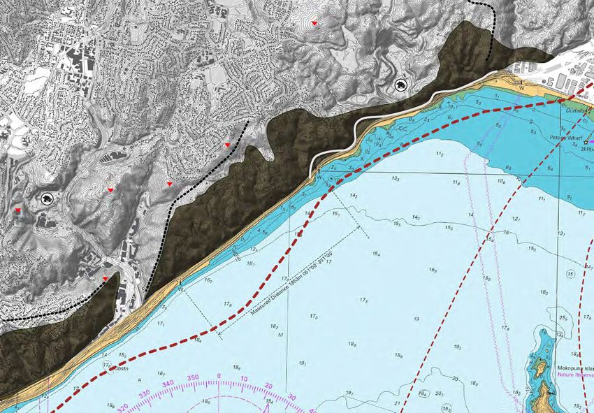
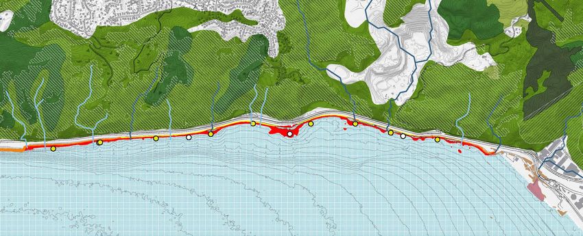
Figure 2.23 View of Te Ana Bay,
looking towards Pari Karangaranga
(Cliff of Echoes).
Te Ara Tupua Ngā Ūranga ki Pito-One Cultural & Environmental Design Framework (CEDF) - NZ EPA
2. Context
Te Ara Tupua Ngā Ūranga ki Pito-One Cultural & Environmental Design Framework (CEDF) - NZ EPA
Context

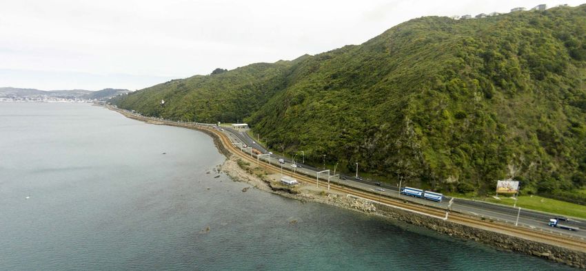
This section of the CEDF                                                      2.1 A Dynamic Coastal Landscape                                                   All of the major faults in the Wellington Region (and the subduction
                                                                                                                                                                interface) have the potential to rupture causing instant and severe damage
                                                                                                                                                                to the built environment and transportation networks, and to change the
sets out the contextual                                                       The landscape along the Project route is dynamic and ever-changing                landscape surrounding the Project area, Wellington City and the wider
                                                                                                                                                                region.
analysis that has informed
                                                                              with a highly modified reclaimed coastline. The natural land forms are
                                                                              characterised by historic and ongoing seismic activity and high energy
                                                                              coastal processes such as waves, strong winds and tides.                          In the event of a strong earthquake, significant liquefaction and/or ground
the Project vision, principles                                                The narrative of Te Ara Tupua clearly expresses a dynamic landscape
                                                                                                                                                                shaking amplification is anticipated in the Pito-One area3. Low lying
                                                                                                                                                                land and streams along the harbour edge (including the Project area)
and design themes.                                                            created by the Tupua. The word Tupua refers to phenomenon and the
                                                                              narrative of Ngāke and Whātaitai, in creating the harbour Te Whanganui
                                                                                                                                                                could also be at risk of a tsunami and temporarily elevated water levels,
                                                                                                                                                                as experienced in the 1855 Wairarapa Earthquake (page 44). These
                                                                              a Tara and Te Awa Kairangi, the Hutt River, are expressive of the land            seismic matters are key to the design of any structures for the Project.
The purpose of the contextual analysis is to fully understand the area, its   formation events that characterise the area.
                                                                                                                                                                Escarpment and Uplifted Landforms
complexities, and to establish the key constraints and opportunities of
the Project. Understanding the Project context is essential to ensure the     The Project design response does address these dynamic conditions, and
                                                                              the effects of future sea-level rise and climate change. A design response        Wellington harbour occupies a down faulted valley with remnant ridges of
vision and objectives are achieved. A deep understanding of the existing
                                                                              to climate change provides an opportunity to consider resilience for the          Matiu (Somes) and Mākaro (Ward) Islands remaining above sea level.
environment is key to the development of practicable and effective design
measures to avoid and manage adverse effects and to build in benefits,        wider road and rail transport corridors, as reflected in the objectives.
                                                                              In line with the NZCPS and the Coastal Hazards and Climate Change                 A steep, uplifted escarpment provides a prominent backdrop to the coastal
positive outcomes.
                                                                              Guidance Manual (MfE 2017), the Project design must give consideration            shelf of the Project area, rising to approximately 200m. To the south, the
                                                                              to effects and hazards over a 100 year timeframe. As a result, the design         escarpment is defined by the Ngā Ūranga Gorge and stream (Waitohi).
The context analysis considers aspects of the broader coastal and cultural
                                                                              for this Project includes allowance for adaptive response for the predicted       Various short, sharp streams descend the face of the escarpment, most
landscape setting and urban connections that have shaped the existing
                                                                              climate change effects and sea-level rise (SLR) over that time. Safety for        notably Waihinahina Stream at Horokiwi and Korokoro Stream north of
environment of Ngā Ūranga ki Pito-One.
                                                                              pedestrians, cyclists and other user groups in this environment is also           the Pito-One interchange. All streams are culverted under the transport
                                                                              essential.                                                                        corridor with Korokoro Stream daylighted through Honiana Te Puni
Section 3 (Design Outcomes) brings the high level design themes and
                                                                                                                                                                Reserve into a naturalised stream mouth through reclaimed land.
context analysis together to describe specific design measures and
parameters that should be integrated to achieve the vision and objectives
for the Project.                                                              Faults & Geology                                                                  The existing road and rail transport corridor from Ngā Ūranga to Pito-One
                                                                                                                                                                is built on the narrow raised platform, uplifted during the 1855 Wairarapa
                                                                                                                                                                earthquake (Figure 2.65 on page 47). Subsequent transport and
Sections 4 and 5 includes the draft masterplan, cross sections and            Seismic Context
                                                                                                                                                                reclamation projects have removed headlands and ends of spurs, and
illustrations, as developed to be consistent with the design outcomes in
                                                                                                                                                                introduced rip rap and concrete sea walls with backfill to extend the shelf
this CEDF.                                                                    Wellington is a seismically active city, sited upon the meeting point of two
                                                                                                                                                                area for road and rail. The uplifted coastal shelf and modifications resulted
                                                                              tectonic plates; The Australian Plate and the subducting Pacific Plate1.
                                                                                                                                                                in a relatively linear coastline with engineered structures interspersed with
                                                                              Major faults in the region include: The Ohariu Fault, Otaki Forks Fault,
                                                                                                                                                                minor remnant headlands, shallow gravel beaches and offshore natural
                                                                              Wairarapa Fault, and Wellington Fault (Figure 2.24).
                                                                                                                                                                rocky outcrops.
                                                                              The prominent Wellington Fault is closest to the Project, some 250-450m
                                                                                                                                                                To the south of the headland known as Rocky Point (below the
                                                                              offshore, aligned sub-parallel to the Path (Figure 2.25). The land directly
                                                                                                                                                                escarpment face known as Pari Karangakaranga) is Tahataha roa ‘the long
                                                                              west of this is slowly rising (including the Project area), whereas land to the
                                                                                                                                                                beach’. To the north there are distinct bays and a greater number of gravel
                                                                              east is sinking2. The Wellington Fault passes under much of Wellington’s
                                                                                                                                                                beaches and off shore rocky outcrops, as the sea floor is much shallower.
                                                                              key transportation infrastructure such as the SH1, the central railway
                                                                              station, ferry terminals, and a number of Hutt Valley bridges.

26                                                                                                                                                                      Te Ara Tupua - Ngā Ūranga ki Pito-One CEDF | Waka Kotahi | September 22, 2020
Te Ara Tupua Ngā Ūranga ki Pito-One Cultural & Environmental Design Framework (CEDF) - NZ EPA
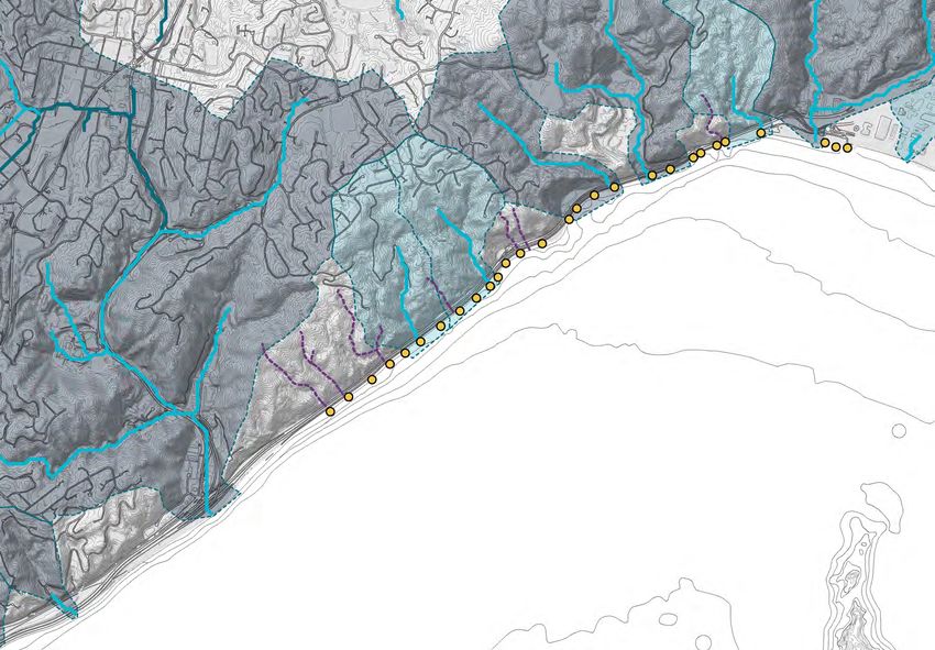
Coastal Faults &                                                                                                                                                                                                                                              1:20,000 scale bar                                               N

Geological Features                                                                                                                                                                                                                                           0m         200m 400m                          1000m

                                                                                                                        lt
Legend.                                        Geological Map                                                       au                                                                                               Woodridge                                Horokiwi
                                                                                                                  sF                                                                                                 Spur
                                                                                                               ork                                                                                                                                            Spur

                                                                                                                                                                                                                                                                                         ki Range
           Wellington Fault                    Not to Scale                                                  iF

                                                                                             lt
                                                                                                                                                                                                              288m
                                                                                                           ak                    lt

                                                                                         au
                                                                                                         Ot                    au
                                                                                                                             nF

                                                                                       uF
           Second Order Faults
                                                                                                                            o
                                                                                                                          gt

                                                                                       ari

                                                                                                                                                                                                                                                                                 Maungara
                                                                                                                        in

                                                                                     Oh
           Ridgelines                                                                                               ell
                                                                                                                   W
Coastal Features                                                     Johnsonville
           High Points                                                                                   Pito-One
                                                                                                                                                                                                                                              Horokiwi                                                              Pito-One
           Coastal Escarpment                                                                                                                                                                                                                 Quarry
                                                                                       Ngā Ūranga
           Coastal Bays
                                                                                    Wellington
           Quarry

Chart NZ4633 Wellington Harbour
(Rev 11, 5 July 2019)                                                                                                                                                                                                            Cliff of
                                                                                                                                                                             Brandon’s Rock
                                                                                                                                                                                                                                 Echoes
           Land survey datum                                                                                                                                                 263m

           Intertidal areas
                                                                                                                                                                                                                                  Karanga
           Shallow waters (under 10m deep)                                                                                                                                                                                        Point
                                                                                                                                                                         e
           Deep waters (over 10m deep)                                                                                                                           R  idg
                                                                                                                                      233m
                                                                                                                                                              gi
                                                                                                                                                            an
           Submerged cables                                                                       243m
                                                                                                                                                      p   ar
                                                                                                                                                   Pa
           Beacon                                  Mount Misery
                                                   222m
                                                                  Kiwi
                                                                  Quarry
Geological Map Legend.                                                                                                                                                                                    a
                                                                                                                                                                                                       ro
                                                                                                                                                                                                   ha-
Geological Units (GNS)                                                                                                                    Omega                                                 ta
                                                                                                                                          Spur                                                ha
                                                                                                                                                                                         Ta
           Sandstone:
           Undifferentiated Rakaia terrane                                                   Ngā Ūranga
           Triassic sandstone and mudstone                                                   Gorge
           Sandstone:
           Esk Head sandstone and                                                             100m
           mudstone                                                                                                                                                                                                                    Te Whanganui a Tara
           Gravel:                                                                                                                                                                                                                     (Wellington Harbour)
           Undifferentiated Pleistocene -
           Holocene river deposits
Fault Activity (GNS)                                             rau Rid
                                                                         g e
                                                          Te Wha
           Active
           Inactive or Unknown                                                                                         Ngā Ūranga                                     ult)
                                                                                                                                                      ma         in fa
                                                                                                                                              Fault (
                                                                                                                                    lington
                                                                                                                                Wel

                                                                                                                                                                                                                                                                                                    Mokopuna
Figure 2.24 Top Left.. New Zealand                                                                                                                                                                                                                                                                     Island
Geological Map. GNS, http://data.gns.cri.nz/
geology/
Figure 2.25 Coastal and Geological Features.                                                                                                                                                                                                                                          Matiu/ Somes
Information sourced from New Zealand                                                                                                                                                                                                                                                         Island
Topographic Map. NZ Topo Map , https://www.
topomap.co.nz/ and Marine Chart (Rev 11, 5
July 2019)

Te Ara Tupua - Ngā Ūranga ki Pito-One CEDF | Waka Kotahi | September 22, 2020                                                                                                                                                                                                                                                      27
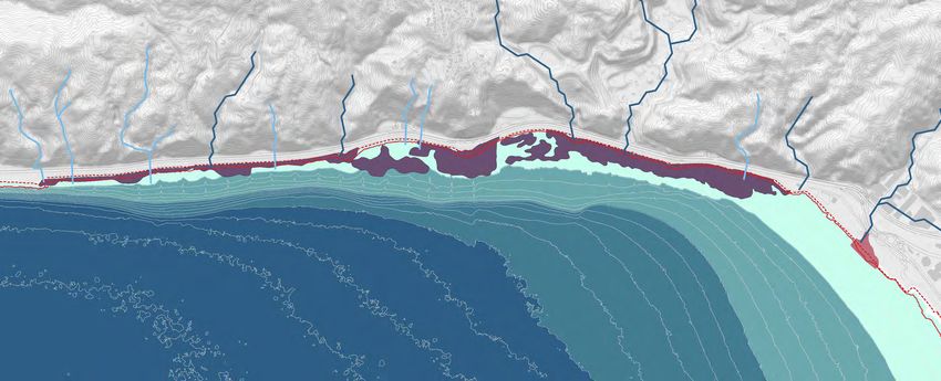
Te Ara Tupua Ngā Ūranga ki Pito-One Cultural & Environmental Design Framework (CEDF) - NZ EPA
Context
Faults & Geology

Natural Landforms and Outcrops                                                      Near-shore Bathymetry                                                                                  Present Day Tide Levels
Natural soils, found at Rocky Point, and the gravel beaches along the
existing seawall are a mixture of cobble, gravel and sand deposits,
driftwood and accumulated sediments/soft muds from adjacent
catchments (predominantly the Hutt River, Te Awa Kairangi) and the
minor streams flowing off the escarpment. The former ends of the
escarpment spurs - headlands - can also be identified below the water
                                                                                         Ngā Ūranga                                                                   T5
line, now characterised by an eroded pattern of rocky reefs overlaid by soft             Gorge                                              T3     T4
                                                                                                           T2
sediments with outcrops emerging above low tide, particularly north of
                                                                                 Representative
                                                                                            T1 cross-shore transects of the shoreline and seabed (Figure 3-10) were extracted to use
Rocky Point; the greatest area of remaining natural land along the coastal       in the resilience profile design. The transects further illustrate how the Harbour bathymetry  varies
                                                                                                                                                                            Pito-One
edge.                                                                            along the Project corridor. At the southern end (transect T0) the seabed drops steeply to depths of
                                                                                 15 m at only 30 m from the existing shoreline while near Petone beach (Transect T4) the depthT6
The underlying geology of the escarpment is largely comprised of                 reaches 5 m at 300 m from the existing shoreline. This variable seabed bathymetry will cause the
                                                                                 wave properties along the project foreshore to vary, although this has not been applied to the
greywacke4. Weathering has changed much of this into a yellow clay-rich          resilience profile design for simplicity. Storm-tide and wave setup are not influenced by local
material5 which can be problematic for vegetation establishment, especially      variations in the seabed bathymetry.
when paired with the strong coastal winds of Wellington Harbour, Te
Whanganui a Tara.                                                                                                                                                                          Figure 2.27 Present-day tide marks at Queen’s Wharf, Wellington relative to Wellington Vertical
                                                                                                                                                                                           Datum-1953 (WVD-53). Sourced from Project Revetment Design Technical Report.

The impacts of ground shaking during earthquakes varies depending on
bedrock geology; the soft and less compacted gravel deposits along the                                                                                                                     This drawing has been prepared to support Notices of Requirement
coastline will behave differently to the hard greywacke hills. The Project                                                                                                                 and resource consent applications. All information including areas and
                                                                                                                                                  T6                                       measurements are indicative, are subject to detailed design and final
design will need to respond to this.                                                                                                              T5                                       survey, and may change.
                                                                                                                                                  T4
The geology also affects visual character of a place and the existing                                                                             T3
habitats - such as the soft sediment, rocky reef, intertidal beaches, existing
rock revetment and edges of the rail corridor (see Ecology and Character
Areas and Values on following pages).

Shape of the Sea Floor                                                                                                                            T2
                                                                                                                                                  T1

Along the immediate coastal edge of the Project, harbour depths reach
                                                                                 Figure 3-10: Cross-shore transects along the Project coastline. Transect locations shown in Figure 3-9.
18m, and grade from very steep slopes at Ngā Ūranga to much flatter
                                                                                 Important  measurements
                                                                                    Figure 2.26  Cross-shorefrom  the existing
                                                                                                              transects        cross-shore
                                                                                                                        along the           transectsTransect
                                                                                                                                   Project coastline. which relate  to the
                                                                                                                                                              locations    revetment
                                                                                                                                                                         shown in plan
beach profiles near Pito-One (Figure 2.26). This change in seabed profile is        image
                                                                                 design areabove,
                                                                                            showntransects
                                                                                                   in Tableshown   above
                                                                                                            3-7. The      right. Sourced
                                                                                                                     measurements        from the Project Revetment Design Technical
                                                                                                                                      include:
associated with the Wellington Fault uplift and river/beach/wave sediment           Report.
transport6. These are matters of particular relevance to the construction            x   Crest elevation = 3.0 m WVD-53 : the tie-in point between the current land and the
of new seawalls and any offshore habitats. The shape of the sea floor also               proposed reclamation structure. This elevation is the starting point for the revetment
                                                                                         resilience profile.
determines the exposure of intertidal feeding grounds for birds requiring
further design considerations to minimise impacts to these areas.                    x   Foreshore slope = 0.36 : from 0 to +2 m WVD-53 elevation which is the upper slope of the
                                                                                         existing structure.

                                                                                     x   Nearshore slope = 0.10 : from MLWS10 (-0.465) to -4.5m WVD-53 elevation which is the
                                                                                         slope of the seabed close to the existing shoreline which will determine the toe-elevation of
                                                                                         the proposed reclamation.

                                                                                     x   Offshore slope = 0.36 : from -4.5 to -10 m WVD-53 elevation which is the seabed slope at
                                                                                         greater depths for determining the toe-elevation of the reclamation if a wider reclamation is
28                                                                                       selected.                                                                                                   Te Ara Tupua - Ngā Ūranga ki Pito-One CEDF | Waka Kotahi | September 22, 2020
Te Ara Tupua Ngā Ūranga ki Pito-One Cultural & Environmental Design Framework (CEDF) - NZ EPA
Coastal Processes

Mean Sea Level, Tides and Currents                                              Waves                                                                         Coastal processes will influence the design of the coastal edge and bridge
                                                                                                                                                              structures and addresses a 100 year timeframe to ensure the Project
Mean sea level (MSL) is the base level of the ocean on which all waves,         Wave conditions within Wellington Harbour, Te Whanganui a Tara, are the       is future proofed against sea-level rise. Coastal processes are also key
storm-tides and other hydrodynamic processes (such as tsunami waves             result of locally generated winds combined with ocean swell, which enters     considerations for user experience, comfort and safety, and will inform
and tidal currents) are superimposed on (Figure 2.27) Mean sea level in         the harbour through Wellington Heads from Cook Strait. When these             the design response to the character and habitats along the coastline.
Wellington Harbour, Te Whanganui a Tara, is +0.195m above Wellington            waves reach the coastline they break at the beach, revetment or seawall       Understanding coastal processes are key to the design measures that
Vertical Datum 19537.                                                           causing wave run-up and over-topping. The heights of the waves along          can be used to create a naturalised edge through the varied design of the
                                                                                the Ngā Ūranga ki Pito-One foreshore are strongly influenced by wind          revetment and vertical seawalls, that actively avoid and minimise loss of
Tides in the harbour are typically within a tidal range of 1.25m during mean    direction, and are greatest in a southerly wind.9                             existing gravel beach habitats and natural rocky outcrops.
spring tides. Mean High Water Springs (MHWS) has an elevation of +0.82m
above Wellington Vertical Datum 1953. These matters are key to design           Waves are a powerful dynamic force affecting the coastline between Ngā
for an adaptive response to SLR and management of over-topping during           Ūranga and Pito-One in a number of ways:
storm surges.
                                                                                • Wave erosion weathers and alters the shape of the coastal shoreline
Due to a sheltered marine location, the currents along the Ngā Ūranga             and reclaimed edges through repeated strong impacts onto the natural
ki Pito-One foreshore are very slow. Because of this, current circulation         shoreline or man-made reclaimed edge (Figure 2.28).
can be influenced by weather conditions and flows from Te Awa Kairangi.         • Wave run-up and over-topping affects comfort levels and safety for
In calm weather the slow tidal currents are too weak to mobilise seabed           pedestrians, and other user groups along coastal routes, and large
sediments. Like the tidal currents, sea bed sediment movement is therefore        wave events have the potential to damage and disrupt adjacent
highly influenced by weather conditions (wind/waves) and proximity to             transportation corridors and properties. There are two types of wave
flows from stream/river mouths. It is important to consider these process to      over-topping; white water spray and green water surges. White water
minimise any adverse effects on gravel beaches which are habitats utilised        spray (Figure 2.16) occurs regularly, rarely causes damage, but does
by Threatened or At Risk bird species.                                            make user experience uncomfortable, while green-water surges occur
                                                                                  occasionally, with potentially hazardous volumes of water over-topping
Storm Tides                                                                       the edge, which can cause erosion and damage structures. Green water
                                                                                                                                                              Figure 2.28 Strong southerly gales and high tides caused wave erosion and washout of the
                                                                                  over-topping probably contributed to the 2013 rail washout (Figure 2.15).   railway line near Ngā Ūranga in June 2013, David Morgan.
In simple terms, a storm-tide is the peak sea level reached during and
event. Median sea level in Wellington Harbour, Te Whanganui a Tara,
during a 1 in 100 year storm-tide is 1.32m above Wellington Vertical Datum      Tsunami
1953. During a storm-tide event, waves are expected to increase the sea
level along the shoreline by a further 0.2m 8 therefore increasing the          Wellington Harbour, Te Whanganui a Tara, (and the Project area) is at risk
hazard.                                                                         from earthquake-generated tsunamis due to its proximity to Cook Strait
                                                                                and local major fault lines. The Project area is identified as evacuation
Climate Change                                                                  zone by the Wellington Region Emergency Management Office (WREMO).
                                                                                Extreme tsunami events can cause devastating damage to a city and incur
In addition to sea-level rise, climate change will influence storm intensity,   many fatalities.
storm tracks, storm-tides and waves throughout New Zealand. Extreme
winds are also likely to increase slightly in winter and decrease slightly in
summer. There is also likely to be an increase in cyclones (sub-tropical
and mid-latitude low pressure systems) in the Tasman Sea over the
summer. Storm surges could be expected to become more frequent for the
Wellington region.
                                                                                                                                                              Figure 2.29 Wind-driven white-water spray over revetment crest along Ngā Ūranga to Pito-One
                                                                                                                                                              foreshore during southerly winds in February 2004. Source: B.Scott, valleysignals.org.nz.

Te Ara Tupua - Ngā Ūranga ki Pito-One CEDF | Waka Kotahi | September 22, 2020                                                                                                                                                                            29
Te Ara Tupua Ngā Ūranga ki Pito-One Cultural & Environmental Design Framework (CEDF) - NZ EPA
Context
Coastal Processes

The Waiwhetu Aquifer                                                                      Wind                                                                             Streams and Coastal Marine Area

There are two aquifers beneath Wellington Harbour, Te Whanganui a                         Wellington is well known for its strong winds. This is largely due to the        Along the project length there are seven moderate to steep streams as
Tara: the Waiwhetu Aquifer and the Moera Aquifer. The Waiwhetu Aquifer                    proximity and influence of Cook Strait, which produces high winds more           classified in the decision version of the NRP 2019 which flow down the
provides more than 40% of Wellington’s freshwater demands (including                      frequently than any other lowland location in New Zealand11.                     escarpment. They are then piped under the transport corridor and into
Porirua and Lower Hutt), and can rise to as much as 70% of the demand in                                                                                                   the harbour (Figure 2.31). All of these streams have Policy P70: quality of
summer. 10                                                                                Wind data specific to the Project area is not available, however it is known     discharge applied to them which is to address aquatic ecosystem health
                                                                                          that the predominant winds for the Project area are north-westerly in            and mahinga kai33.
The extent of the Aquifer Protection Zone shown in Figure 2.30 is a                       spring and summer, with more southerlies in winter. The hills alongside
consideration for the design and construction methods along the extent                    the Project corridor provide some protection, making the Project corridor        A stream survey to determine permanent, intermittent or ephemeral
of the Project. In particular, the depth of any piles and foundations for                 one of the most sheltered areas of the harbour in a north-westerly. The          classes has not been undertaken for the project. However, incidentally
seawalls and the construction of rail over-bridge.                                        regular rowing, skiing and kayaking activities in this area of the harbour       Korokoro, Waihinahina and an un-named stream that runs through Gilberd
                                                                                          rely on this calm water. In a southerly wind, however, the Project corridor is   Bush Reserve have been observed by the project Ecologist as part of an
                                                                                          highly exposed. Southerly winds are also colder, and whip up large waves,        adjacent project34. The remaining four streams are not validated and have
                                                                                          with the wind driving wave spray inland (refer Figure 2.16). Southerly winds     been located through a high level desktop and site observation exercise.
                                                                                          generate wetter, colder environments, making pedestrians and cyclists
                                                                                          more uncomfortable than the north-westerly winds.                                  • Ngā Ūranga, Waitohi Stream: a permanent stream not included
Hutt Aquifer                                                                                                                                                                   within project.
Protection Zone                                                                           In the Wellington City Council District Plan Design Guidelines for Wind, the       • Unnamed Stream: undetermined stream class.
                                                                                          general effects of winds upon people are summarised as:                            • Unnamed Stream: undetermined stream class.
                                                                                                                                                                             • Unnamed Stream: a modified permanent stream, referred to as
                                                                                            • 10 metres/second: generally the limit for comfort when standing or               Gilberd Bush Stream in the project Ecological Assessment.
                                                                               Pito-One       sitting for lengthy periods in open space.                                     • Waihinahina Stream: a modified permanent stream, influenced by the
                                                                                            • 15 metres/second: generally the limit of acceptability for comfort               Horokiwi Quarry.
                                                                                              whilst walking.                                                                • Unnamed Stream: undetermined stream class.
                                                                                            • 18 metres/second: threshold of danger level.                                   • Korokoro Stream: a permanent stream.
                                                                                            • 23 metres/second: completely unsuitable for walking and assumed
                                                                                              cycling.                                                                     Other waterways (indicatively mapped in Figure 2.31) flow into the harbour
                                                                                                                                                                           over the escarpment, and are assumed to be associated with stormwater
       Ngā Ūranga
                                                                                          While there is no Project-specific wind data available, the Ngā Ūranga ki        flows from the urban areas above.
       Gorge                                                                              Pito-One Project area is exposed to southerly winds over the Harbour. It is
                                                                                          likely that wind speeds of over 18m/s will be experienced during a strong
                                                                                          southerly. Design outcomes for the Project are to consider this and the
                                                             Mokopuna
                                                                Island                    opportunity to integrate sheltering elements, whilst ensuring good views
                                                                                          and visibility.
                                                        Matiu/ Somes
                                                               Island

Figure 2.30 Hutt Aquifer Protection Zone.     Legend.
Source: Greater Wellington Regional Council
                                                        Te Ara Tupua - Ngā Ūranga ki
                                                        Pito-One Path
                                                        Hutt Aquifer Protection Zone.
                                                        Greater Wellington decision
                                                        version Natural Resources Plan
                                                        (2019)

30                                                                                                                                                                                 Te Ara Tupua - Ngā Ūranga ki Pito-One CEDF | Waka Kotahi | September 22, 2020
Coastal Processes                                                                                                                                                                  1:20,000 scale bar                                         N

                                                                                                                                                                                   0m        200m 400m                 1000m

Streams & Coastal
Marine Area

Legend.
           Te Ara Tupua - Ngā Ūranga ki
           Pito-One path
           Other waterways based on                                                                                                                                                                           C                        Pito-One
           desktop and site observations
           Outlets - streams/stormwater                                                                                                                                                              B
                                                                                                                                                                                                                        Honiana Te
           Permanent Stream
                                                                                                                                                                                                               Korokoro Puni Reserve
River Classes (GWRC NRP Decisions                                                                                                                                                                              Stream
version)
           Class 2                                                                                                                                                             Waihinahina
           Moderate gradient and steep                                                                                                                                         Stream
           gradient coastal, hard sedimentary                                                                                                                   Gilberd Bush
                                                                                                                                                                Stream
           Class 6
           Low gradient, small
Stream Catchments
           Catchments for Permanent
           Streams located within the Te Ara                                                                                     A
           Tupua site
           Other Stream Catchments

Note: Korokoro Stream is part of
Schedule F1: Rivers and lakes with                                                                                                     Te Whanganui a Tara
                                                                                                                                         (Wellington Harbour)
significant indigenous ecosystems
in the NRP (Decisions Version).

Permanent streams sourced from
the project Ecological Assessment.
                                                                                                      A                                                B                                                 C
Outlets based on engineers survey.

Ngā Ūranga Stream / Waitohi
Stream is not within the Ngā                                                    Ngā Ūranga Stream/
                                                                                Waitohi Stream
Ūranga ki Pito-One project area.

Figure 2.31 Streams and Coastal Marine Area.

                                                                                                     Figure 2.32 Unnamed Stream with channel        Figure 2.33 Unnammed Stream at Honiana           Figure 2.34 Korokoro Stream looking
                                                                                                     structure located at Ch2360.                   Te Puni Reserve with a water main crossing it.   upstream from existing shared path. Rail and
                                                                                                     Source: Isthmus                                Located at Ch 4500. Source: Isthmus              services crossing. Source: Isthmus

Te Ara Tupua - Ngā Ūranga ki Pito-One CEDF | Waka Kotahi | September 22, 2020                                                                                                                                                                     31
Context
Ecology

Keeping the natural                                                Vegetation on the coastal shelf (SH2 and rail corridors
                                                                   and coastal edge) is minimal due to the clearing and
                                                                                                                                     Ecology
environment and
                                                                   maintenance associated with the road and railway
                                                                   construction and upkeep. Naturalised coastal vegetation           Legend.
                                                                   features at Honiana Te Puni Reserve near the streams.
kaitiakitanga top of                                               The Project Ecological Assessment identifies 56 plant
                                                                                                                                                 Streams
                                                                                                                                                 Class 2 Moderate gradient and
                                                                                                                                                 steep gradient coastal, hard

mind.                                                              species along the alignment, comprising 35 exotic and 21
                                                                   native species. Native vegetation was generally found within
                                                                                                                                                 sedimentary (GWRC)
                                                                                                                                                 Other waterways based on
                                                                                                                                                 desktop and site observations
                                                                   areas of amenity roadside plantings, wilding along the road
The ecological environment surrounding the Project area            edges and where small headlands provided sufficiently sized                   WCC Draft SNA
has been highly modified through past reclamation and              platforms between the sea and the railway, such as at Rocky                   HCC SNR
development to provide the road and rail infrastructure required   Point14.                                                          Lizard Habitat in Honiana Te Puni Reserve
between Wellington City and the Hutt Valley. However, diverse                                                                        (project Ecologist Survey 2020)
bird and marine habitats have endured along the coastal edge,      In this broader area two native plant species are identified as               Potential Lizard Habitat
largely undisturbed by people or dogs because of limited           Threatened or At Risk:                                            Survey Locations (project Ecologist GIS
access.                                                               • Manuka (Leptospermum scoparium var. scoparium) is            Survey Data 2019)
                                                                                                                                                                                                                      Ngā Ūranga
                                                                         identified as At Risk (declining).                                      Sediment Quality                                                     Gorge
Policies under the NZCPS require adverse and significant              • Pohutukawa (Metrosideros excelsa) is identified as
adverse biodiversity effects to be avoided including existing                                                                                    Subtidal Ecology
                                                                         Threatened (Nationally Vulnerable).
high value, At Risk, and Threatened bird and marine habitats.                                                                        Avifauna (Bird) Values the Habitat Supports
                                                                                                                                     (project Ecologist GIS Survey Data 2019)
The Project is required to actively avoid and minimise impact      However, these species do not trigger any rarity criteria due
on these habitats and it offers an opportunity to improve the                                                                                    High
                                                                   to the context in which they are found along the alignment15.
long term condition of the coastal edge through a naturalised                                                                                    Moderate
approach and to introduce new terrestrial habitats and values      Reptiles                                                                      Low
along this edge of Wellington Harbour, Te Whanganui a Tara.                                                                                      Gravel beach
                                                                                                                                                                                                                   Ngā Ūranga Stream/
                                                                   Three species have been recorded within 2km of the Project        Vegetation (LCDB v4.1)**                                                      Waitohi Stream
                                                                   alignment:                                                                    Low producing grassland
Plants
                                                                      • Northern grass skink (Oligosoma polychroma).                             Exotic forest
                                                                      • Ngahere gecko (Mokopirirakau sp. ‘Southern North
Vegetation on the escarpment alongside the Project is broadly                                                                                    Gorse and or broom
                                                                        Island’).
categorised as: gorse/broom (exotic weed species), exotic             • Raukawa gecko (Woodworthia maculata).                                    Broadleaved indigenous
                                                                                                                                                 hardwoods
forest, and indigenous podocarp broadleaved forest12. Draft
Significant Natural Areas (SNA), have been identified over most    Based on reptile habitat preferences, the Project alignment       Schedule F4 (GWRC, PNRP)
of the escarpment under the WCC proposed plan change and a         provides potential habitat for northern grass skink and                       Korokoro Estuary
Significant Natural Resource Site (SNR) has also been identified   raukawa gecko, both of which are classified as Not                **A classification of New Zealand’s terrestrial
in the HCC plan (Figure 2.35).                                     Threatened.                                                       ecosystems                                          Figure 2.35 Terrestrial Ecology within the
                                                                                                                                     Nicholas J.D. Singers and Geoffrey M. Rogers        Project area

The draft SNA sites ( WC109) along the coastal escarpment          Lizard habitat is limited to areas of vegetation which
adjacent the Project are more than 100ha of nearly continuous      provides cover (i.e. not mown grass) and artificial and natural
forest between Wellington and the Hutt Valley, and contain         rock/debris piles above high tide. Given the small size and
several remnants of broadleaved forest, including tawa,            isolated nature of these habitats it is expected that lizards
rewarewa, hinau and kohekohe, and areas of mahoe forest.           will be in low numbers if present at all within the existing
The large area and diverse habitat make it home to a variety of    alignment, however, there are opportunities to integrate
native birds and lizards13.                                        habitat in the design and enhance existing gravel and
                                                                   boulder field habitats at Honiana Te Puni Reserve.
32                                                                                                                                                                          Te Ara Tupua - Ngā Ūranga ki Pito-One CEDF | Waka Kotahi | September 22, 2020
Figure 2.36 Reptiles recorded within 2km of                      Raki-tarutaru mokomoko                       Ngahere mokomoko                                      Raukawa mokomoko
the Project alignment.                                           Oligosoma polychroma, Northern grass skink   Mokopirirakau sp. ‘Southern North Island’,
Northern grass skink: https://www.flickr.com/photos/121262944@
                                                                                                                                                                    Woodworthia maculata,, Raukawa gecko
                                                                                                              Ngahere gecko
N04/45173204805                                                                                                                                                                                                                                1:10,000 scale bar                                              N
Ngahere gecko: https://www.flickr.com/photos/151723530@
N05/41168363935/sizes/l/                                                                                                                                                                                                                       0m        100m 200m                     500m
Raukawa gecko: https://www.flickr.com/photos/151723530@
N05/42067335251/sizes/l/

                                                                                                                                                                                                                         Horokiwi
                                                                                                                                                                                                                         Quarry

                                                                                                                                                                                   Te Ana Bay
                                                                                                                              Paroro Bay
                                                                                                                                                                                                               Waihinahina
                                                                                                                                                                                                                   Stream
                                                                                                                                                           Karanga Point
                                           Tahataha Roa

                                                                                                                                                                                                                                                                                Honiana Te Puni
                                                                                                                                                                                                                                                                                         Reserve

                                                                                                                                                                                                                                                                                             Korokoro Stream        Pito-One

                                                                                                                                                                                                                        Figure 2.37 Examples of appropriate coastal plant species for the
                                                                                                                                                                                                                        Project.
                                                                                                                                                                                                                        Image sources:
                                                                                                                                                                                                                        http://www.cfgphoto.com/photo-29941.htm
                                                                                                                                                                                                                        https://www.australianseed.com/shop/item/tetragonia-implexicoma-
                                                                                                                                                                                                                        http://www.terrain.net.nz/friends-of-te-henui-group/plants-native-
                                                                                                                                                                                                                        botanical-names-m-to-q/flax-mountain-phormium-cookianum.html
                                                                                                                                                                                                                        http://www.terrain.net.nz/friends-of-te-henui-group/plants-native-
                                                                                                                                                                                                                        botanical-names-m-to-q/muehlenbeckia-complexa-pohuehue.html
Pohuehue                                                         Harakeke                                     Kokihi                                                Panahi
Muehlenbeckia complexa, wire vine                                Phormium cookianum, coastal flax             Tetragonia implexicoma, NZ spinach                    Calystegia soldanella, shore convolvulus

Te Ara Tupua - Ngā Ūranga ki Pito-One CEDF | Waka Kotahi | September 22, 2020                                                                                                                                                                                                                                  33
Context
Ecology

Birds                                                                                         d                                      d                       Figure 2.38 Threatened or At Risk bird            fluttering shearwater: https://www.flickr.com/
                                                                                         ne                                     ne                           species along Te Ara Tupua.                       photos/mosesharold/32878689778/sizes/l/
                                                                                      te                                     te

                                                                                                                         a
                                                                                  a
Despite being a highly modified environment, coastal birds use the existing                                                                                  Image sources:                                    Variable oystercatcher: https://www.flickr.com/

                                                                                                                       re
                                                                                re
                                                                                                                                                                                                               photos/joerghempel/6710742395/sizes/l/

                                                                                                                     Th
                                                                              Th
rock revetment, cobble/gravel/sand beaches and off shore outcrops                                                                                            Caspian tern: https://www.flickr.com/photos/
for nesting, roosting and foraging. The Project Ecological Assessment                                                                                        almiyi/9534165426/sizes/l/                        Black shag: https://www.flickr.com/
                                                                                                                                                                                                               photos/156515825@N04/35369226473/
records 14 bird species on and adjacent to the alignment. Two species are                                                                                    Reef heron: https://www.flickr.com/photos/        sizes/l/
                                                                                                                                                             patrick_k59/40724593200/sizes/l/
classified as ‘Nationally Threatened’, eight species as ‘At Risk’, and four                                                                                                                                    Little black shag: https://www.flickr.com/
species as ‘Not Threatened.’16                                                                                                                               Red-billed gull: https://www.flickr.com/photos/   photos/mollivan_jon/21751480655/sizes/l/
                                                                                                                                                             kookr/14240404263/sizes/l/
                                                                                                                                                                                                               white-fronted tern: https://www.flickr.com/
The black-backed gull, variable oystercatcher and little blue penguin have                                                                                   Pied shag: https://www.flickr.com/photos/         photos/scmscm2/33809137136/sizes/l/
                                                                                                                                                             volvob12b/9380796346/sizes/l/
been recorded nesting along the Project route.                                                                                                                                                                 Northern blue penguin: https://www.flickr.com/
                                                                                                                                                                                                               photos/pie4dan/3705981571/sizes/l/
Threatened Species:                                                           Mātukutuku                             Taranui
• Taranui (Hydroprogne caspia), caspian tern.                                 Egretta sacra sacra,
                                                                                            sacra,                   Hydroprogne caspia,
                                                                                                                                  caspia,
                                                                              Reef heron                             Caspian tern
• Mātukutuku (Egretta sacra sacra), reef heron.

At Risk Species:
• Kororā (Eudyptula minor iredalei), northern blue penguin.
• Tarapunga (Laurus novaehollandiae scopulinus), red billed gull.
• Tara (Sterna s. striata), white fronted tern.
• Kāruhiruhi (Phalacrocorax varius), pied shag.
• Tōrea pango (Haematopus unicolor), variable oystercatcher.
• Pakahā (Puffinus gavia) fluttering shearwater.
• Kawau pū (Phalacrocorax carbo novaehollandiae), black shag.
• Kawau tūī (Phalacrocorax sulcirostris), little black shag.

Not Threatened Species:
• Kawau paka (Phalacrocorax melanoleucos brevirostris), little shag.                                                                                                                                           Tarapunga
                                                                              Kāruhiruhi                             Pakahā                                  Tōrea pango
                                                                                                                                                                                                               Laurus novaehollandiae scopulinus
• Karoro (Larus d. dominicanus), black-backed gull.                           Phalacrocorax varius varius,
                                                                                                   varius,           Puffinus gavia, fluttering shearwater   Haematopus unicolor,
                                                                                                                                                                          unicolor, variable
                                                                                                                                                                                                               Red-billed gull
                                                                              Pied shag                                                                      oystercatcher
• Parekareka (Stictocarbo p. punctatus), spotted shag.
• Matuku moana (Egretta novaehollandiae), white-faced heron.

These species bring a focus to design measures required to actively avoid
effects and ongoing habitat disturbance.

                                                                              Kawau pū                               Kawau tūī                               Tara                                              Kororā
                                                                              Phalacrocorax carbo novaehollandiae,
                                                                                                  novaehollandiae,   (Phalacrocorax sulcirostris),           Sterna s. striata,
                                                                                                                                                                       striata,                                Eudyptula minor iredalei,
                                                                              Black shag                             Little black shag                       white-fronted tern                                Northern blue penguin
34                                                                                                                                                                      Te Ara Tupua - Ngā Ūranga ki Pito-One CEDF | Waka Kotahi | September 22, 2020
Stream Ecology & Habitat                                                        no habitat currently for native fish. The only stream habitat related to the                                         Figure 2.39 At Risk freshwater fish species
                                                                                                                                                                                                     observed within Korokoro Stream. NIWA FFDB
                                                                                coastal edge is the small reach above SH2 19.
Korokoro Stream is recognised for its high native fish values due to its                                                                                                                             Image sources:
large and protected catchment. Historically this stream provided a rich         An unnamed stream (although referred to as Gilberd Bush Stream in the                                                bluegill bully: https://teara.govt.nz/en/
source of fresh water species and mahinga kai for nearby Pā including the       Project Ecological Assessment) runs immediately south of Waihinahina                                                 photograph/11120/bluegill-bully

delicacy lamprey eels, piharau.                                                 Stream. This is a very steep stream including waterfall sections. The                                                long fin eel: https://www.flickr.com/photos/
                                                                                                                                                                                                     alan_cressler/8374793183/sizes/l/
                                                                                combination of the SH2 culvert, historic disturbances during earlier quarry
Korokoro Stream (and tributaries) is listed as a waterway with significant      activities, water falls, and historic piping mean fish passage has been                                              kōaro: https://www.flickr.com/photos/
                                                                                                                                                                                                     stephenmahony/25813890657/sizes/l/
indigenous ecosystems in Schedule F1 of Greater Wellington Regional             obstructed for many years. While the habitat in the upper section has no
Council’s decision version proposed Natural Resources Plan17. NIWAs             fish potential, it remains a habitat of some quality for macroinvertebrate                                           giant kōkopu: https://ourauckland.
                                                                                                                                                                                                     aucklandcouncil.govt.nz/articles/
freshwater fish database (FFDB) indicates the following fish species within     communities20. Gilberd Bush stream is not listed as a river with significant                                         news/2017/06/giant-milestone-for-whitebait/
the Korokoro Stream, four of which are At Risk while the remaining nine         indigenous ecosystems in Schedule F1 of the NRP (decisions version).
species are Not Threatened18.                                                                                                                                  Tōpūtea tāpihapiha-purū
                                                                                As mentioned in Coastal Processes on previous pages, there are various         Gobiomorphus hubbsi,
                                                                                                                                                                            hubbsi bluegill bully
At Risk fish species within Korokoro Stream:                                    un-named streams along the Project site. The Project Ecological
• Tuna (Anguilla dieffenbachii), Longfin eel.                                   Assessment suggests that most are unlikely to have any native fish
• Kōkopu (Galaxias argenteus), Giant kōkopu.                                    populations however, there is a possibility that banded kokopu or kōaro
• Kōaro (Galaxias brevipinnis), Kōaro.                                          might be present, however, passage to the sea is significantly interrupted
• Inanga (Galaxiias maculatus).                                                 by the SH2 and rail culvert system. Design of the revetment and seawalls
• Tōpūtea tāpihapiha-purū (Gobiomorphus hubbsi), Bluegill bully.                have the opportunity to provide greater potential for fish passage by
                                                                                addressing the perched outfalls that are extended through the new
Not Threatened fish and invertebrate species within Korokoro Stream:            footprint.
• Shortfin eel (Anguilla australis).
• Banded kōkopu (Galaxias fasciatus).
• Common bully (Gobiomorphus cotidianus).
• Redfin bully (Gobiomorphus huttoni).
• Koura (Paranephrops planifrons).                                                                                                                              Kōaro                                Kōkopu
• Common smelt (Retropinna retropinna).                                                                                                                         Galaxias brevipinnis,
                                                                                                                                                                         brevipinnis kōaro           Galaxias argenteus, giant kōkopu

Brown trout (Salmo trutta) is also present within Korokoro Stream.

The Project Ecological Assessment also identifies several areas suitable for
inanga spawning habitat seaward of the train tracks.

Historically Waihinahina Stream (near Horokiwi) had a more open
catchment with three gully tributaries combining to form a perennial
stream and a series of waterfalls. Much of this system is now piped under
the quarry. No fish remain in the middle and upper catchment and there is

                                                                                                                                                               Tuna
                                                                                                                                                               Anguilla dieffenbachii,
                                                                                                                                                                        dieffenbachii long fin eel

Te Ara Tupua - Ngā Ūranga ki Pito-One CEDF | Waka Kotahi | September 22, 2020                                                                                                                                                                       35
Context
Ecology

Marine Habitats                                                                   Marine Ecology
The marine environment along the foreshore of the Project area is                 and Habitats
highly modified due to the historic dredging of the harbour and previous
reclamation works (refer to Figure 2.65 and Figure 2.70). It is also subject to
                                                                                  Legend.
the impact of stormwater from SH2 and Horokiwi Quarry, which introduces
sediment and contaminants to the coast during rainfall events via a                          Streams
                                                                                             Class 2 Moderate gradient and
number of stormwater discharge points. However, wave action generally                        steep gradient coastal, hard
                                                                                             sedimentary (GWRC)
prevents sediment and contaminant build up at the immediate coastline.21
                                                                                             Other waterways based on                                                      Ngā Ūranga
                                                                                             desktop and site observations                                                 Gorge
There are four marine habitats relevant to the Project area that are
                                                                                             Mean High Water Springs
identified in the respective schedules of the NRP (decision version) as
                                                                                             Mean Low Water Springs
outlined in the Project Ecological Assessment22. They are:
                                                                                             1m bathymetry contours

• Korokoro Estuary (Schedule F4: Sites of significant indigenous                             0m to -5m
  biodiversity values in the coastal marine area).                                           -5m to -10m
• Seal haulouts (Schedule F5: Habitats with significant indigenous                           -10m to -15m
  biodiversity values in the coastal marine areas).                                          -15m to -20m                                                                Ngā Ūranga Stream/
                                                                                                                                                                         Waitohi Stream
• Macroalgae (Schedule F5: Habitats with significant indigenous                              -20m to -21m
  biodiversity values in the coastal marine areas).                               Marine Habitat (GIS data supplied by project
• Subtidal rocky reefs (Schedule F5: Habitats with significant indigenous         Ecologist, 2019 survey)
  biodiversity values in the coastal marine areas).                                          Macroalgae
                                                                                             2019 Subtidal Ecology
The subtidal habitat is less modified than the reclaimed foreshore, and
                                                                                  Schedule F4 (GWRC, PNRP)
as a result contains a higher diversity of species and habitat types. In the
                                                                                             Korokoro Estuary
intertidal area, greater diversity was noted where there are natural rock
outcrops and open rip rap and large boulders in contrast to the existing
                                                                                  Figure 2.40 Marine ecology within the
concrete and stone inlaid sections of the sea wall. The rocks, gravels, sands     Project area, Isthmus
and sediments of both the intertidal and subtidal environment provide a
range of habitats for a variety of marine life, including:

• A variety of algaes with macroalgae habitats across the submerged
  rocks reefs.
• Shellfish species such as green-lipped mussel, kina and cockle.
• Fish species such as kokopara (triplefin), blue cod, sting ray.
• Other species and macroinvertebrates such as tube worms, and cushion
  star, cats eyes, sea squirts and whelks.

                                                                                                                                                           Figure 2.41 Example of a gravel intertidal foraging
                                                                                                                                                           habitat. Boffa Miskell

36                                                                                                                               Te Ara Tupua - Ngā Ūranga ki Pito-One CEDF | Waka Kotahi | September 22, 2020
1:10,000 scale bar                                           N

                                                                                                                                                                                                        0m       100m 200m                  500m

                                                                                                                                                                             Horokiwi
                                                                                                                                                                             Quarry

                                                                                                                                           Te Ana Bay
                                                                                             Paroro Bay
                                                                                                              Karanga Point

                                     Tahataha roa                                                                                                                  Waihinahina
                                                                                                                                                                       Stream

                                                                                                                                                                                                                                   Honiana Te Puni
                                                                                                                                                                                                                                          Reserve

                                                                                                                                                                                                                                                       Korokoro
                                                                                                                                                                                                                                                        Estuary

                                                                                                                                                                                                                             Figure 2.42 Sub-tidal photos by Boffa
                                                                                                                                                                                                                             Miskell

Kina                                           Rāwaru                           Pōrohe                                        Kapu parahua                                       Kaeo
Evechinus chloroticus, sea urchin.             Parapercis colias, blue cod      Mytilus edulis, blue mussel                   Patiriella regularis, cushion star                 Cnemidocarpa bicornuta, sea squirt

Te Ara Tupua - Ngā Ūranga ki Pito-One CEDF | Waka Kotahi | September 22, 2020                                                                                                                                                                                        37
Context
2.2 A Layered Cultural Landscape

The name Te Ara Tupua
references the Project’s
association with Ngāke and
Whātaitai, the Tupua of Te
Whanganui a Tara.
As recorded in the Project Cultural Impact Assessment by Morrie Love, this
is an area with strong association with the Te Atiawa hapu of Ngāti Te Whiti,
Ngāti Tawhirikura, and others of Te Atiawa nui tonu particularly those who were
connected to Pito-One Pa and Ngā Ūranga Pā. The area has a rich and layered
cultural history stemming from the creation of Aotearoa. This narrative and the
Kaitiaki Strategy principles developed for the Project to realise its mana and mouri
underpin the overall vision and design themes for the Project.

Early Māori History

“During the 1820s and 1830s, members of Te Āti Awa and other tribes left their         Figure 2.43 Migration of Te Āti Awa and other tribes from Taranaki to Kapiti coast and Wellington harbour, Isthmus
ancestral home in Taranaki and travelled south in four great migrations, finally
reaching the Kapiti coast and Wellington Harbour. In 1832 the Te Āti Awa people
from Ngāmotu moved south in considerable numbers. This migration was known as
Te Heke Tamateuaua. Ngāti Tawhirikura were led by Tautara, Ruaukitua, Ngātata-i-
te-rangi, Te Wharepōuri and Hēnare Te Keha. Also in the migration were the people
of Ngāti Mutunga, led by the chiefs Rangiwāhia, Hautohoro, Onemihi, Te Ito from
Waitara and Te Puponga (William Keenan) from New Plymouth.

After their journey from Taranaki, Te Āti Awa people from Ngāmotu settled first at
Waikanae. The hapū (sub-tribe) Te Mana of Ngāti Mutunga were living at Pito-One
(Petone) just north of Wellington, having arrived in a previous migration from
Taranaki. They invited the Ngāmotu chiefs Te Puni, Te Wharepōuri, Te Matangi
and his son Te Manihera Te Toru to settle with them there, since they were close
kin. While the Ngāmotu people were in the Wairarapa, the situation along the Kapiti
coast had deteriorated because of pressures on land, and old rivalries. Haowhenua,
a long-running and inconclusive battle in 1834, saw another Taranaki migration,
known as Paukena, arrive from Waitara. These Te Āti Awa people were led by Te
Rangitāke (also known as Wiremu Kīngi). 23
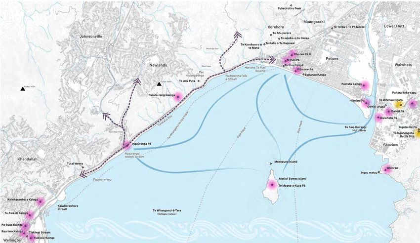
                                                                                       Figure 2.44 Main settlements and natural features along Te Ara Tupua, Isthmus

38                                                                                                                                                                           Te Ara Tupua - Ngā Ūranga ki Pito-One CEDF | Waka Kotahi | September 22, 2020
Te Ara Tupua
Cultural Landscape

Legend.                                                                              Old Trail to
                                                                                     Takapu &
           Te Ara Tupua - Ngā Ūranga ki                                              Porirua
           Pito-One Path
           Indicative historic waka routes

           Indicative historic land trails
           Streams
           Sites of significance to Tangata
           Whenua
           Indicative Kainga/ Villages/
           Campsites

           Battle Grounds

           Significant high points                                    Old Trail to
                                                                      Johnsonville
Figure 2.45 Te Ara Tupua Cultural landscape,
Isthmus

Sources:
Wellington City District Plan
Hutt City District Plan
Lands and Survey dept, Wellington 1928

                                                                                                             Ngāke and Whātaitai
                                                                                                    Tupua of Te Whanganui a Tara

Te Ara Tupua - Ngā Ūranga ki Pito-One CEDF | Waka Kotahi | September 22, 2020                                                      39
Context
A Layered Cultural Landscape

The following text on A Layered Cultural Landscape has been extracted                          Pito-One Pā                                                                       Ngā Ūranga Pā
from the Cultural Impact Assessment (CIA) by Morrie Love, unless
otherwise stated.                                                                              “A description of Pito – one Pa was given in the reminiscences of E               “The old Pā site of Ngāuranga was connected strongly with other Pā
                                                                                               Maxwell who knew this area in 1860 – early 1870s:                                 around Te Whanganui a Tara (Wellington Harbour). Ngā Ūranga principally
                                                                                                                                                                                 linked with Pito-One Pa and its people. Ngā Ūranga was the home of the
Tangata Whenua at Pito-One and Ngā Ūranga                                                         “Pito-One when I first knew it was, with the exception of a Māori pa and       old Paramount Chief Te Wharepōuri. His land interests went to Manihera
                                                                                                  one or two small cottages clustered near the site of the present railway       Te Toru on his death in 1842 and leadership transferred to Honiana Te
“To identify the tangata whenua who have a direct association with the Te                         station, a waste if sand, shingle, rushes, etc. The pa – Te Puni’s – stood     Puni at Pito-One Pā. The Pā is also associated with Rawiri Te Motutere who
Ara Tupua Project area, this CIA relies in part on the expert knowledge of                        at some distance in the direction of the river. It was a large palisaded pa,   moved from his Pā, Koangaumu in Titahi Bay to Ngā Ūranga.
the Waitangi Tribunal . Today, the descendants of the original inhabitants                        almost circular, I think.
of Pito-One Pā and Ngā Ūranga Pā are from various hapū of Te Āti Awa.                             The whares inside were at least in curved lines. There were two                Ngā Ūranga Pā had strong association with the Te Āti Awa and Ngāti
They originate largely from Ngā Motu (New Plymouth) in Taranaki.                                  entrances, one towards the west, the other on the opposite side looking        Mutunga. The name was probably associated with the previous residents
The people of Pito-One Pā and Ngā Ūranga Pā were predominantly from                               towards the river. The palisading was high and in sections between             of Ngāti Ira. The name of the stream that came down the narrow and
the Ngāti Te Whiti and Ngāti Tawhirikura hapū of Te Āti Awa iwi. These                            much taller posts. These tall posts were carved, and those on either           precipitous gully that is now the Ngā Ūranga gorge was Waitohi. In Māori
hapū and whānau are all connected to Te Tatau o Te Po Marae and its                               side of the gateways were much more elaborately done, as also were             times there was limited flat land for gardens giving way to the bush-clad
associated urupā - Te Puni Urupa. Te Tatau o Te Po was built in 1933                              the planks which formed the archways over the gate. There was a clear          gully. Tuna (eels) were caught in weirs in the stream to supplement the
between Hutt Road and the Melling Railway line close to what is now the                           road between the two entrances. On either side of this roadway were            fish caught in the Harbour. The village at Ngā Ūranga had a population of
Dowse Interchange.                                                                                the large structures, and in curved rows behind them were the whares.          48 in a census in 1842 which was the year of Te Wharepōuri’s death and
                                                                                                  The pa when I went over it had the usual supply of Māori articles,             when Tacy Kemp did his census in 1850 the population had dropped to
Descendants of the original inhabitants of Pito-One Pā and Ngā Ūranga                             except that there was a most unusual number of large calabashes, far           34. Kemp noted that the people of the Pa were closely connected to the
Pā are eligible by whakapapa to become registered members of the                                  greater number that I have ever seen in any pa or kainga.”                     people of Pito-One Pa and after Te Wharepōuri’s death looked to Te Puni
Port Nicholson Block Settlement Trust (PNBST), the post settlement                                                                                                               for leadership. The village degenerated rapidly after that time and land
governance entity representing the interests of Taranaki Whānui ki te                          Colonel William Wakefield of the New Zealand Company has a house within           disputes marked the future of the place.
Upoko o te Ika (Taranaki Whānui).”                                                             the Pa palisades. The early New Zealand Company buildings were adjacent
                                                                                               to the Pa. Although Pito-One was not the largest Pa around the harbour, it        Ngā Ūranga or the resting place for waka, was also closely associated
                                                                                               was very significant providing the home for Ngati Tawhirikura and Ngati Te        with the island Matiu in the middle of the Harbour and the people had
                                                                                               Whiti along with other Te Atiawa hapu.”                                           connections with all of the sites along this part of the Harbour to Pito-One.”

Figure 2.46 Te Puni’s New Pā (Te Tatau-o-te-po). Behind the Pito-One Pā.
By courtesy J. W. Marshall

Figure 2.47 (Far right) Shows the canoe monument to Te Wharepōuri on flat land at the mouth
of Ngā Ūranga stream, beside Ngā Ūranga Pā.

Brees, Samuel Charles, 1810?-1865. [Brees, Samuel Charles] 1810-1865 :[Ngā Ūranga gorge
and stream. ca 1843]. Ref: B-031-008. Alexander Turnbull Library, Wellington, New Zealand. /
records/22873774

40                                                                                                                                                                                       Te Ara Tupua - Ngā Ūranga ki Pito-One CEDF | Waka Kotahi | September 22, 2020
Honiana Te Puni and Te Wharepōuri

“Honiana Te Puni was a Te Āti Awa chief of high lineage who was
descended from Takarangi and Rau-Mahora. His own father was
Rerewha-i-te-Rangi, son of Aniwaniwa and Tawhirikura, the originators
of the Tawhirikura subtribe of Te Ati Awa. His mother was Te Puku. Te
Puni lived at Pukeariki Pā, New Plymouth, and took part in the successful
defence of Otaka against the Waikato. Later he accompanied the followers
of Wharepōuri, Rawa-Kitua, and Ngatata, southward in the
“heke” Tama te Uaua.

His people settled in the neighbourhood of Cook Strait or Whanganui-a-
Tara and, by about 1832, he was fully established at his pa on the beach
at “Pito-One”, now known as Petone. In 1840 Te Wharepōuri and Te Puni
welcomed the first New Zealand Company pioneers to Port Nicholson.
Soon after, Te Puni was one of the signatories of the Treaty of Waitangi
and the deed of purchase of the land about Wellington. He died on
5 December 1870 and was accorded a State funeral with full military
honours24.

Te Wharepōuri was born in Taranaki, the son of Te Whiti and Hine-te-Uru.
He was a grandson of Te Whitikatura by his principal wife, Rongouaroa,
and was thus a senior chief of the Ngāti Tawhirikura branch of Te Āti Awa,
being senior to his cousins Makore Ngātata-i-te-rangi and Te Puni. He was
also closely related to Te Whiti, the prophet of Parihaka.

Te Wharepōuri fought at Motunui in 1822 and in the defence of
Pukerangiora. In 1826 he served with Whatanui’s taua against the Ngāti
Kahungunu. He was one of the Te Āti Awa party when Te Karawa was
killed at Pūtiki Pā by the Ngāti Ruanui and joined the party of Waikatos
under Te Waharoa, Tarapipipi, and Naera, whom Ngātata summoned to
avenge this insult.

Te Wharepōuri’s last years were burdened by serious illness and he died
at Ngā Ūranga on 22 November 1842. On his deathbed he is said to have
advised his successor, Te Puni, “Muri nei ki aku taonga Māori ki aku taonga     Figure 2.48 Te Wharepōuri gesturing with a mere in his right hand, the Tory behind him and a     Figure 2.49 Honiana Te Puni standing, with full facial moko, clad in a dogskin cloak and holding
                                                                                rowboat with four men being rowed towards the ship. A Māori canoe and several men are shown      a taiaha in his right hand. Behind him is Wellington Harbour, Te Whanganui a Tara, with two Māori
Pakeha” (“Care for my Māori and European people when I am gone”) Te             behind Te Wharepōuri on the left.                                                                by the shore to the left, and Pito-One Pā, a canoe and a flagpole with the New Zealand Company
Wharepōuri was buried at Pito-One and a cenotaph was erected to his                                                                                                              flag on the right. The western Hutt hills are in the background.
                                                                                [Heaphy, Charles] 1820-1881 :Warepori or “Dark house”. Day & Haghe. [London, Smith, Elder
memory” 25                                                                      1845]. Wakefield, Edward Jerningham 1820-1879 :Illustrations to “Adventure in New Zealand”.      [Heaphy, Charles] 1820-1881 :Epuni or “Greedy”. Day & Haghe. [London, Smith, Elder 1845].
                                                                                Lithographed from original drawings taken on the spot by Mrs Wicksteed, Miss King, Mrs Fox,      Wakefield, Edward Jerningham 1820-1879 :Illustrations to “Adventure in New Zealand”.
                                                                                Mr John Saxton, Mr Charles Heaphy, Mr S. C. Brees and Captain W. Mein Smith. London, Smith       Lithographed from original drawings taken on the spot by Mrs Wicksteed, Miss King, Mrs Fox,
                                                                                Elder & Co, 1845.. Ref: PUBL-0011-02-1. Alexander Turnbull Library, Wellington, New Zealand. /   Mr John Saxton, Mr Charles Heaphy, Mr S. C. Brees and Captain W. Mein Smith. London, Smith
                                                                                records/22308729                                                                                 Elder & Co, 1845.. Ref: PUBL-0011-02-2. Alexander Turnbull Library, Wellington, New Zealand. /
                                                                                                                                                                                 records/22314439

Te Ara Tupua - Ngā Ūranga ki Pito-One CEDF | Waka Kotahi | September 22, 2020                                                                                                                                                                                                     41
Context
A Layered Cultural Landscape

Taranaki Whānui ki te Upoko o Te Ika                                           The Port Nicholson Block Settlement Trust (PNBST) was established               Honiana Te Puni Reserve
                                                                               in August 2008 to receive and manage the Taranaki Whānui Treaty
“At the time of the signing of the Treaty of Waitangi (6 February 1840), the   settlement package as well as social, cultural, economic and environmental      The Honiana Te Puni Reserve was vested in the Trustees of the PNBST
iwi (tribes) living in the Te Whanganui a Tara (Wellington Harbour) area       interests of Taranaki Whānui. Taranaki Whānui, as a part of their Treaty        by section 60 of the Port Nicholson Block (Taranaki Whānui ki te Upoko o
originated from the Taranaki region of the North Island. The collective        Settlement has a Statutory Acknowledgement over Te Whanganui a                  te Ika) Claims Settlement Act 2009. The reserve is designated as a Local
name given to these iwi is Taranaki Whānui ki Te Upoko o Te Ika (Taranaki      Tara (the Harbour), the CMA and holds significant cultural interests in         Purpose Reserve under the Reserves Act 1977 and it is managed by Hutt
Whānui). Their occupation at the time and continued residence attributes       all waterways and the wider environment throughout the Te Ara Tupua             City Council. A management plan for the Reserve has yet to be developed
Taranaki Whānui the rights and duties of mana whenua – traditional             Project area.                                                                   post settlement however ideas around what the long-term future might be
guardians of Te Whanganui a Tara and associated lands.                                                                                                         have been discussed over the years since 2009.
                                                                               Ngāti Toa Rangatira
Taranaki Whānui are mana whenua of the Te Whanganui a Tara area.                                                                                               The significance of the Honiana Te Puni Reserve for Te Āti Awa-Taranaki
The iwi that make up Taranaki Whānui migrated to the Wellington area           The Ngāti Toa Rangatira area of interest spans the Cook Strait. It covers       Whānui and the hapū of Ngāti Te Whiti and Ngāti Tawhirikura (associated
in the 1820s through to 1830s. Since that period, Taranaki Whānui have         the lower North Island from the Rangitikei in the north and includes the        with Pito-One Pā and Te Tatau o Te Pō) is that the area was part of the
maintained ahi kā (permanent occupation). Taranaki Whānui established          Kāpiti Coast, Hutt Valley, and Wellington areas, as well as Kāpiti and Mana     whole environs of Pito-One Pā with gardens and burial grounds in the
kāinga and papakāinga around the Wellington Harbour (and other areas).         Islands. It includes large areas of the Marlborough Sounds and much of          locality.
The traditional kāinga, papakāinga, māra kai (gardens) mahinga kai (food       the northern South Island. Ngāti Toa Rangatira’s area of interest is about 4
gathering areas) and other sites of cultural significance have now been        million hectares in total.                                                      The foreshore and seabed in the vicinity were equally significant for the Pā
largely subsumed by urban development. Yet, Taranaki Whānui remain.                                                                                            environs both for mahinga kai purposes as well as for swimming and waka
Migration has meant that Taranaki Whānui are now a minority within their       The Ngāti Toa Rangatira Treaty Settlement, also provides a Statutory            activity.
tribal takiwā (area). Taranaki Whānui are still the mana whenua. Taranaki      Acknowledgement over Te Whanganui a Tara. Ngāti Toa Rangatira’s claims
Whānui are those people who descend from one or more of the recognised         relate primarily to the loss of land and resources in both the South and        This area was probably significant as a local fishery for the Pā and Kainga,
tīpuna (ancestor) of:                                                          North Islands, their exclusion from the Tenths estates in both islands, and     however it deteriorated rapidly with colonisation and particularly with the
                                                                               the loss of the iwi’s maritime empire. The Crown has recognised its actions     arrival of industries at Korokoro, including the Pito-One Woollen Mills,
•    Te Āti Awa;                                                               undermined the maritime authority exercised by Ngāti Toa over the Cook          the Pito-One Railway workshop and then the Gear Meat Company. Water
•    Taranaki;                                                                 Strait region in the 1800s, including the iwi’s authority over sea trading      quality in the Korokoro Stream and Te Tuarā-whati–o-Te Mana Stream was
•    Ngāti Ruanui;                                                             routes and the whaling industry in that area.                                   largely good from the undeveloped catchment to where it discharged on
•    Ngāti Tama;                                                                                                                                               the flats close to the Harbour but quality deteriorated rapidly through the
•    Ngāti Mutunga; and                                                        The claims also relate to the Crown’s land purchasing policies which led        industrial area. The Korokoro Stream provided the early water supply for
•    Other iwi from the Taranaki area.                                         to the loss of virtually all of the iwi’s extensive lands in both islands and   Pito-One Town as it developed from 1840.”
                                                                               include the Crown’s failure to set aside adequate reserves and to ensure
As mana whenua of the Capital City of Aotearoa/New Zealand, Taranaki           that the iwi retained sufficient lands for their future needs.
Whānui’s vision is to ensure that their members not only maintain their
place within the takiwā (tribal area), but, are thriving and prospering. The   The iwi’s longstanding grievances include the Crown’s deliberate
loss of land and the fragmentation of Taranaki Whānui descendants and          undermining of Ngāti Toa’s authority, the undertaking of a coercive
whānau over the decades creates significant challenges as they seek to         military campaign against the tribe and their chiefs, Te Rauparaha and
restore the rightful place of their members and descendants within their       Te Rangihaeata, the kidnapping and detention of Te Rauparaha, and
takiwā. The tribal takiwā (area) of Taranaki Whānui, extends from Pipinui to   the sale of land under duress while the chief was detained. The Crown
Remutaka, down to Turakirae, across to Rimurapa and back up to Pipinui.        has acknowledged that its detention of Te Rauparaha without trial for 18
Taranaki Whānui has overlapping interests with Ngāti Toa Rangatira,            months was a breach of the Treaty of Waitangi.
Rangitāne o Wairarapa and Ngāti Kahungunu ki Wairarapa.

42                                                                                                                                                                    Te Ara Tupua - Ngā Ūranga ki Pito-One CEDF | Waka Kotahi | September 22, 2020
You can also read