Downscaling Climate Modelling for High-Resolution Climate Information and Impact Assessment - Clima-Med
←
→
Page content transcription
If your browser does not render page correctly, please read the page content below
Handbook N°6
                                                                                       Seminar held in Lecce, Italy
                                                                                               9 - 20 March 2015
Euro South Mediterranean Initiative:
Climate Resilient Societies
Supported by Low Carbon Economies

Downscaling Climate Modelling for High-Resolution
Climate Information and Impact Assessment
                                Project implemented by
        Project funded by the
         A project funded by
        European Union
                                AGRICONSULTING CONSORTIUM
                                Agriconsulting    Agrer     CMCC    CIHEAM-IAM Bari

         the European Union     d’Appolonia      Pescares   Typsa   Sviluppo Globale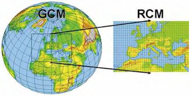
1. INTROduction          2. DOWNSCALING SCENARIOS              3. SEASONAL FORECASTS         4. CONCEPTS & EXAMPLES   5. CONCLUSIONS         6. WEB LINKS       7. REFERENCES

DISCLAIMER

The information and views set out in this document are
those of the authors and do not necessarily reflect the offi-
cial opinion of the European Union. Neither the European
Union, its institutions and bodies, nor any person acting
on their behalf, may be held responsible for the use which
may be made of the information contained herein.
The content of the report is based on presentations de-
livered by speakers at the seminars and discussions trig-
gered by participants.

Editors: The ClimaSouth team with contributions by Neil Ward (lead author), E. Bucchignani, M. Montesarchio, A. Zollo, G. Rianna,
N. Mancosu, V. Bacciu (CMCC experts), and M. Todorovic (IAM-Bari).

Concept: G.H. Mattravers Messana
Graphic template: Zoi Environment Network
Graphic design & layout: Raffaella Gemma
Agriconsulting Consortium project directors: Ottavio Novelli / Barbara Giannuzzi Savelli
ClimaSouth Team Leader: Bernardo Sala

                                                Project funded by the
                                                A project funded by
                                                European Union
                                                the European Union                                                                              Acronyms | Disclaimer | CS website          2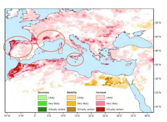
1. INTROduction    2. DOWNSCALING SCENARIOS    3. SEASONAL FORECASTS         4. CONCEPTS & EXAMPLES           5. CONCLUSIONS              6. WEB LINKS      7. REFERENCES

FOREWORD

The Mediterranean region has been identified as a cli-         ernment, the private sector and civil society. The ClimaSouth handbooks are
mate change hotspot by the Intergovernmental Panel on          based on peer-to-peer seminars and training sessions held by the project,
Climate Change (IPCC). Most countries in the region are        which are designed to support national administrations in the development
already experiencing rising temperature, increasing water      and implementation of climate change policy; they further help stakeholders in
scarcity, rising frequency of droughts and forest fires, as    the region to engage more effectively in the global climate change framework.
well as growing rates of desertification. A common under-
                                                               This sixth handbook builds on the previous ClimaSouth E-handbook N.2 “Im-
standing is thus emerging in the region that fighting cli-
                                                               proving Climate Information”, by focussing on the process of downscaling and
mate change is essential, by employing both mitigation
                                                               translating climate knowledge into actionable climate information that may
and adaptation measures. These may also open new op-
                                                               support on-the-ground adaptation. Material on climate change downscaling
portunities for further economic development, particularly
                                                               is primarily illustrated in the context of dynamical downscaling, while seasonal
those associated with low carbon options.
                                                               forecasts are illustrated with reference to the suite of techniques available in
The EU-funded ClimaSouth project supports climate              statistical downscaling. Both dynamical and statistical approaches, are illustrat-
change mitigation and adaptation in nine Southern Medi-        ed through various examples. We hope this handbook will contribute to en-
terranean partner countries: Algeria, Egypt, Israel, Jordan,   hancing capacity for the downscaling of seasonal forecasts and global change
Lebanon, Libya, Morocco, Palestine and Tunisia. The pro-       scenarios in the South Mediterranean region.
ject assists partner countries and their administrations in
                                                               May your reading be informative and interesting.
transitioning towards low carbon societies while building
climate resilience and promoting opportunities for sustain-
able economic growth and employment. The project also
                                                               Nicola Di Pietrantonio                         Matthieu Ballu
supports South-South cooperation and information shar-         European Commission                            European Commission
ing on climate change issues within the region as well as      Directorate General for Neighbourhood          Directorate-General for Climate Action
                                                               and Enlargement Negotiations (DG NEAR)         (DG-CLIMA)
closer dialogue and partnership with the European Union.
As part of its efforts to enhance climate change strategic
                                                               CLIMASOUTH HANDBOOKS
planning, the ClimaSouth project is producing a series of
                                                               Handbook N. 1: Building Capacity & Mainstreaming Climate Change Policy
handbooks tailored to the needs of the South Mediter-          Handbook N. 2: Improving Climate Information
ranean region. The key users targeted include relevant         Handbook N. 3: An Introduction to Greenhouse Gas Inventories and MRV
government departments at operational and policy lev-          Handbook N. 4: Long-range Energy Alternatives Planning System (LEAP) & Greenhouse Gas (GHG) Modelling
                                                               Handbook N. 5: Low-Emission Development Strategy (LEDS)
els, climate change units and committees, decision mak-        Handbook N. 6: Downscaling Climate Modelling for High-Resolution Climate Information and Impact Assessment
ers, meteorological services, and members of local gov-        Handbook N. 7: Connecting Downscaling, Impacts and Adaptation: A Summary

                                    Project funded by the
                                    A project funded by
                                    European Union
                                    the European Union                                                                               Acronyms | Disclaimer | CS website            3
1. INTROduction                  2. DOWNSCALING SCENARIOS                         3. SEASONAL FORECASTS                      4. CONCEPTS & EXAMPLES                          5. CONCLUSIONS                         6. WEB LINKS                       7. REFERENCES

CONTENTS

Disclaimer.................................................................................................................................................................................................................................................................................... 2
Foreword..................................................................................................................................................................................................................................................................................... 3
List of selected acronyms........................................................................................................................................................................................................................................................... 5

1. Introduction......................................................................................................................................................................................................................... 7
2. Downscaling Climate Change Scenarios.................................................................................................................................................................... 9
  2.1        Introduction and dynamical downscaling concepts.................................................................................................................................................................................................. 9
  2.2        Climate change projections over the ClimaSouth domain..................................................................................................................................................................................... 11
  2.3        Illustration of dynamically downscaled results......................................................................................................................................................................................................... 12
  2.4        Dynamical downscaling practical exercises............................................................................................................................................................................................................. 13
  2.5        Statistical downscaling of regional change scenarios for impact assessment...................................................................................................................................................... 15
		           Methodological discussion........................................................................................................................................................................................................................................ 15
		           Implementation of downscaling bias correction methods (including practical exercise illustration)................................................................................................................. 16

3. Downscaling of Seasonal Climate Forecast Information................................................................................................................................ 18
     3.1 Introduction to seasonal climate forecasts and downscaling approaches............................................................................................................................................................ 18
     3.2 Overview of statistical downscaling concepts and application to seasonal forecasts......................................................................................................................................... 20
4. Concepts and Examples in Using High-Resolution (Downscaled) Climate Information for Impact Assessment............................. 24
  4.1        Challenges in assessing high-resolution climate impacts....................................................................................................................................................................................... 24
  4.2        Uses of high-resolution climate change information for adaptation planning and actions................................................................................................................................ 25
  4.3        Examples of high-resolution climate change impact assessments........................................................................................................................................................................ 26
		           Agricultural sector...................................................................................................................................................................................................................................................... 26
		           Forestry sector............................................................................................................................................................................................................................................................ 27
  4.4        Assessing the high-resolution impact implications of a seasonal forecast........................................................................................................................................................... 29

5. Conclusions........................................................................................................................................................................................................................ 30
6.	WEB LINKS TO FURTHER RELEVANT MATERIAL..................................................................................................................................................................... 31
7.	REFERENCES............................................................................................................................................................................................................................ 33

                                                               Project funded by the
                                                                A project funded by
                                                               European Union
                                                                the European Union                                                                                                                                Acronyms | Disclaimer | CS website                                               4
1. INTROduction   2. DOWNSCALING SCENARIOS   3. SEASONAL FORECASTS   4. CONCEPTS & EXAMPLES   5. CONCLUSIONS         6. WEB LINKS       7. REFERENCES

LIST OF SELECTED ACRONYMS

AR4              IPCC Assessment Report 4
AR5              IPCC Assessment Report 5
CDO              Climate Data Operators
CDF              Cumulative Density Function
CMCC             Euro-Mediterranean Center on Climate Change
COSMO-CLM        Consortium for Small-scale Modeling - Climate Limited-Area Modeling
CORDEX           Coordinated Regional Climate Downscaling Experiment
CPT              Climate Predictability Tool
DGVM             Dynamic Global Vegetation Model
ECMWF            European Centre for Medium-Range Weather Forecasts
ERA              ECMWF Reanalysis
EURO-CORDEX      Europe - CORDEX
GCM              General Circulation Model
GHG              Greenhouse Gas
IAM-Bari         Istituto Agronomico Mediterraneo di Bari
IPCC             Intergovernmental Panel on Climate Change
MED-CORDEX       Mediterranean - CORDEX
MENA-CORDEX      Middle East North Africa - CORDEX
MOS              Model Output Statistics
PCR              Principle Component Regression
PDF              Probability Density Function

                                Project funded by the
                                A project funded by
                                European Union
                                the European Union                                                              Acronyms | Disclaimer | CS website          5
1. INTROduction   2. DOWNSCALING SCENARIOS   3. SEASONAL FORECASTS   4. CONCEPTS & EXAMPLES   5. CONCLUSIONS         6. WEB LINKS       7. REFERENCES

RCM           Regional Climate Model
RCP           Representative Concentration Pathway
SIMETAW       Simulation of Evapotranspiration of Applied Water
SMHI          Swedish Meteorological and Hydrological Institute
SST           Sea-surface Temperature
WCRP          World Climate Research Programme
WL            Web Link

                             Project funded by the
                             A project funded by
                             European Union
                             the European Union                                                              Acronyms | Disclaimer | CS website          6
1. INTROduction    2. DOWNSCALING SCENARIOS    3. SEASONAL FORECASTS   4. CONCEPTS & EXAMPLES     5. CONCLUSIONS         6. WEB LINKS       7. REFERENCES

1.	INTRODUCTION

ClimaSouth organized a workshop in Lecce, Italy (March         tion such as real-time monitoring, seasonal forecasts and
9 - 20, 2015) in collaboration with the Euro- Mediterra-       global change scenarios. Enhancing capacity in the Clima-
nean Center on Climate Change (CMCC). The aim of the           South region for the downscaling of seasonal forecasts and
workshop wasto advance capacity in downscaling climate         global change scenarios was considered especially critical.
modelling for the purpose of high-resolution climate im-       In response to this, the 2015 workshop on downscaling cli-
pact assessment in support of adaptation actions. This was     mate modelling reported on herein addressed both these
achieved through an intense first phase of the workshop
(1.5 weeks), concentrating on climate downscaling con-
cepts and implementation, followed by a second phase (3
days) discussing concepts and providing illustrative exam-
ples in the use of high-resolution climate information for
impact assessment and adaptation. One climate partici-
pant from each country was invited to attend the complete
2 week workshop and one sectoral participant from each
country was invited to join the workshop for the final three
days, when the focus was on impacts. The workshop con-
centrated on the agriculture/forestry and water sectors.
The overall initiative originated following discussions at
the ClimaSouth Regional Workshop on Improving Climate
Information held in April 2014 (see ClimaSouth E-Hand-
book N.2WL1). Capacity for the creation of downscaled cli-
mate information had been recognized as an important
gap in the process of translating climate knowledge into
actionable climate information that could support onthe-
ground adaptation. At the 2014 workshop it ws concluded
that enhanced adaptive management could be better
empowered by a range of downscaled climate informa-

                                    Project funded by the
                                    A project funded by
                                    European Union
                                    the European Union                                                                 Acronyms | Disclaimer | CS website          7
1. INTROduction    2. DOWNSCALING SCENARIOS    3. SEASONAL FORECASTS   4. CONCEPTS & EXAMPLES     5. CONCLUSIONS         6. WEB LINKS       7. REFERENCES

timescales (in this handbook, see Climate Change Sce-          pacts and discussing adaptation options (Project Activity
narios in Section 2 and Seasonal Forecasts in Section 3).      3.1.3). The workshop was structured in a way that increases
The 2014 workshop also recognized that dynamical and           regional cooperation, through joint training and the shar-
statistical approaches to downscaling both had impor-          ing of experiences and practical exercises in the form of
tant roles to play. To provide balance in presenting the       case studies. This handbook is primarily intended for tech-
material, climate change downscaling (Section 2) is pri-       nical professionals and technically informed policy makers
marily illustrated in the context of dynamical downscaling     in the ClimaSouth countries. The aim is to facilitate dis-
(and bias correction), while seasonal forecasts (Section 3)    cussion and action on the improvement of highresolution
are primarily discussed in the context of the suite of tech-   climate information in each country in order to support the
niques available in statistical downscaling. Nonetheless,      enhancement of national adaptation strategies.
as the discussion in these sections describes, dynamical
                                                               The ClimaSouth programme team is grateful to the speak-
and statistical approaches can be effectively applied in
                                                               ers who contributed to the success of the workshop, in
the context of both global change and seasonal forecast
                                                               particular the experts of the CMCC (Climate experts E.
information. Section 4 captures some of the concepts
                                                               Bucchignani, M. Montesarchio, A. Zollo, and impact ex-
and examples discussed in the impacts module of the
                                                               perts G. Rianna, N. Mancosu, V. Bacciu) and invited agri-
workshop.
                                                               cultural impact expert M. Todorovic (IAM-Bari). The learn-
The initiative contributes to the ClimaSouth project struc-    ing achieved at the workshop through practical exercises
ture by improving and analysing climate data relevant for      was, in addition to the above-mentioned science experts,
adaptation (Project Activity 3.1.1), while also focusing on    made possible by the careful attention and support of the
the use of the downscaled information for case study im-       CMCC computer staff.

                                    Project funded by the
                                    A project funded by
                                    European Union
                                    the European Union                                                                 Acronyms | Disclaimer | CS website          8
1. INTROduction    2. DOWNSCALING SCENARIOS      3. SEASONAL FORECASTS     4. CONCEPTS & EXAMPLES        5. CONCLUSIONS          6. WEB LINKS       7. REFERENCES

2.	Downscaling Climate
    Change Scenarios

2.1 Introduction and dynamical
     downscaling concepts
The warming of the climate system in recent decades is evi-       downscaling techniques have been developed which take the large-scale pre-
dent from observations and is mainly related to the increase      dictions provided by a GCM and apply methods to extract implied climate
of anthropogenic greenhouse gas (GHG) concentrations              change information at more regional/local scales.
(IPCC 2013). As a consequence, precipitation will also be         Downscaling methods can be divided into two main categories: statistical
altered, partly because a warmer atmosphere will hold more        methods, which apply transformations to the GCM output, based on rela-
water vapour, resulting in heavier rains. In addition, process-   tionships calculated with high-resolution observations; dynamical methods,
es will be engaged to increase droughts in some locations,        which explicitly solve the process-based physical dynamics of the regional
due in part to larger water absorption from soil and veg-         climate system at high spatial resolution, when driven by the large-scale low-
etation. The main tool for providing insights into possible
future climate changes is climate modelling. Climate mod-
els are mathematical models that simulate the behaviour of
Earth systems based on the fundamental laws of physics.
More specifically, general circulation models (GCMs) simu-
late planet-wide climate dynamics, representing a powerful
instrument for simulating the response of the global climate
system to external forcing (Giorgi 2005).
However, GCMs are generally unsuitable for simulating lo-
cal climate, since they are currently characterized by res-
olutions generally around or coarser than 100 km, while
many important phenomena occur at spatial scales less
than 10 km. Moreover, GCMs do not adequately account
for vegetation variations, complex topography and coast-
lines, which are important aspects of the physical response
governing the regional/local climate change signal. Thus,         Figure 1. A schematic representation of the dynamical downscaling technique.

                                      Project funded by the
                                      A project funded by
                                      European Union
                                      the European Union                                                                        Acronyms | Disclaimer | CS website          9
1. INTROduction     2. DOWNSCALING SCENARIOS       3. SEASONAL FORECASTS    4. CONCEPTS & EXAMPLES     5. CONCLUSIONS          6. WEB LINKS       7. REFERENCES

resolution forcing of the GCM. One of the most effective            RCMs must be validated against observational data sets in
tools, providing high-resolution climate analysis through           order to evaluate the capability of the model to reproduce
dynamical downscaling, is the regional climate model                current climate conditions. This in turn allows to define its
(RCM) (Giorgi and Mearns 1991). RCMs are often able to              deficiencies originating from various modelling assump-
provide an accurate description of climate variability on           tions and their related uncertainties. Two different kinds
local scales (Figure 1). Moreover, RCMs show the capabil-           of data can be used as initial and boundary conditions of
ity to provide a detailed description of climate extremes,          an RCM to evaluate its ability to simulate current climate:
including the statistics of extreme weather events (Rum-            (i) Reanalysis and (ii) GCMs that were driven with currently
mukainen 2010).                                                     observed GHG forcing. The reanalyses most commonly
                                                                    used to perform RCM simulations are the ERA-InterimWL3,
The capabilities of the current generation of RCMs have
                                                                    the latest global atmospheric reanalyses produced by the
been assessed in the framework of several international
                                                                    European Centre for Medium-Range Weather Forecasts
projects. In recent years, the WCRP Coordinated Region-
                                                                    (ECMWF). Reanalyses represent our best estimate of the
al Climate Downscaling Experiment (CORDEXWL2) pro-
                                                                    large-scale observed climate at every time point across
ject (Giorgi et al. 2009), has been established to provide
                                                                    recent decades, since reanalyses are informed by actual
global coordination of regional climate downscaling for
                                                                    observations of the climate system. The ERA-Interim is
improved climate-change adaptation policy and impact
                                                                    available from 1979 and the reanalyses are continuously
assessment. Of course, dynamical downscaling also has
                                                                    updated in real-time. The usage of reanalysis as initial
some drawbacks; for example, dynamical downscaling
                                                                    and boundary conditions of RCMs allows the assessment
is computationally expensive, needing large computing
                                                                    of RCM capability in reproducing the most important cli-
resources, and is strongly dependent on the boundary
                                                                    mate features of a specific region of interest. GCMs (with
conditions that are provided by GCMs (if the large-scale
                                                                    current GHG forcing) are not constrained by atmospheric
GCM simulation is in error, this will transfer to the output
                                                                    observations during their integration, and so may devel-
of the RCM: a concept often referred to as “garbage in–
                                                                    op systematic errors (drift) which can contribute to errors
garbage out”). Also, RCMs (like GCMs) contain semi-em-
                                                                    in the RCMs that they drive. Nonetheless, these experi-
pirical parameterization schemes such as for convection;
                                                                    ments are important, since they provide a base against
it must be assumed that these parameterization schemes
                                                                    which to compare RCM experiments that are driven by
are still valid in a future climate. A further constraint is that
                                                                    GCM climate change projections (IPCC scenarios), and
the spatial resolution of most current-generation models
                                                                    in this way, RCMs generate high-resolution estimates of
is limited to about 1 km, especially for the huge amount
                                                                    climate change projections.
of computational resources required by finer grids, but
also due to the lack of suitable numerical models for               A major source of the uncertainty in RCMs arises from
some processes with such resolution values.                         the large number of parameterized physical processes

                                       Project funded by the
                                       A project funded by
                                       European Union
                                       the European Union                                                                     Acronyms | Disclaimer | CS website          10
1. INTROduction 2. DOWNSCALING SCENARIOS 3. SEASONAL FORECASTS 4. CONCEPTS & EXAMPLES 5. CONCLUSIONS 6. WEB LINKS 7. REFERENCES
within the climate model and the associated unconfined
model parameters. Several studies have demonstrated
the importance of this “parameter uncertainty” for the
simulation of present and future climates, by perturbing
single and multiple model parameters within plausible pa-
rameter ranges determined by expert judgment (Giorgi
and Mearns 1991). Since uncertain model parameters are
responsible for a large part of modelling errors, the pa-
rameter uncertainty is typically constrained by calibration
or tuning methods to improve the agreement between the
climate model and the available observations. This tuning
process is one of the aspects that requires highly skilled
technical human resources in order to effectively imple-
ment and run the RCM.
2.2 Climate Change Projections
over the ClimaSouth Domain
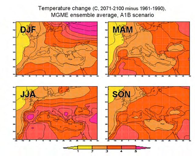
The ClimaSouth domain is located in a transition zone Figure 2. Temperature change for the four seasons (2071-2100 minus 1961-1990),
between the arid climates of the Saharan North Africa/ ensemble average, A1B scenario (from Giorgi and Lionello 2008)
Middle East region and the temperate climates of central
Europe; it is affected by interactions between mid-lati-
“Hotspot” for future climate change. Major impacts on society are expected,
tude and tropical processes. Anticipating climate change
including on agriculture, tourism and water resources.
in the region is further complicated by the existence of a
major enclosed sea (the Mediterranean) with very active Many GCM climate-change projections have been analysed for the Mediter-
regional thermohaline circulation, and linkage to the At- ranean under different GHG forcing scenarios, and many of the projections
lantic Ocean through the Strait of Gibraltar. However, it is are freely availableWL4, WL5. A generally consistent picture has emerged over
already very clear that the broader Mediterranean region recent IPCC assessments, culminating in the recent AR5 (IPCC 2013). Overall,
is very sensitive to climate changes induced by increases increasingly drier and warmer conditions are projected: these conditions are
in GHG concentrations and it has been identified as a particularly evident in summer. As a summary of temperatures from AR4, Fig.
Project funded by the
A project funded by
European Union
the European Union Acronyms | Disclaimer | CS website 111. INTROduction 2. DOWNSCALING SCENARIOS 3. SEASONAL FORECASTS 4. CONCEPTS & EXAMPLES 5. CONCLUSIONS 6. WEB LINKS 7. REFERENCES
2 shows the ensemble average as constructed by Giorgi component for arriving at appropriate adaptation actions (e.g., Vermeulen et
and Lionello (2008). These then, represent the type of al. 2013).
GCM integrations that are subsequently used to drive
At the CMCC, high-resolution climate projections (about 14 km) over the Euro-
RCMs to assess patterns of climate change at higher spa-
Mediterranean area (also including the Black Sea) have been performed with
tial resolution.
the regional climate model COSMO-CLMWL6 (Rockel et al. 2008). Specifically,
two simulations driven by the global model CMCC-CM (Scoccimarro et al.
2011) were carried out over the 1971-2100 period, employing the IPCC RCP4.5
2.3 Illustration of dynamically and RCP8.5 emission scenarios (van Vuuren et al. 2011), chosen as representa-
tive of a world with less (RCP4.5) or more (RCP8.5) pronounced global emis-
downscaled results sions. To illustrate the results, Fig. 3 shows the temperature change projections
Downscaling is particularly important for assessing region-
al climate change for the broader Mediterranean area,
which is characterized by high space variability and many
climate types. Strong land-sea contrasts, land-atmosphere
feedbacks, intense air-sea couplings and aerosol-radiation
interactions, are among the challenging regional charac-
teristics to take into account when dealing with high-reso-
lution climate modelling of the region.
There are several coordinated ensembles of high-resolu- RCP4.5 winter RCP8.5 winter
tion regional climate simulations that are relevant for coun-
tries targeted by the ClimaSouth project. One example is
based on a grid size down to 25 km and on the previous
generation of emission scenarios (the ENSEMBLES pro-
ject, Hewitt 2005). The recent CORDEXWL2 project archives
many relevant simulations considering the new RCP emis-
sion scenarios (van Vuuren et al. 2011). Relevant domains
are MED-CORDEX, EURO-CORDEX (covering much of the
ClimaSouth domain at very high resolution) and MENA- RCP4.5 summer RCP8.5 summer
CORDEX (see next section for more details). Analysis of
multiple models and ensembles of the same model (run
with small changes in initial conditions) are important to Figure 3. Temperature change for winter and summer (2071-2100 minus 1971-2000)
building an impression of uncertainty, which is a significant projected with COSMO-CLM.
Project funded by the
A project funded by
European Union
the European Union Acronyms | Disclaimer | CS website 121. INTROduction 2. DOWNSCALING SCENARIOS 3. SEASONAL FORECASTS 4. CONCEPTS & EXAMPLES 5. CONCLUSIONS 6. WEB LINKS 7. REFERENCES
for the period 2071-2100 compared to 1971-2000 for both The RCM COSMO-CLM has been widely adopted in sever-
scenarios.1 Considering the RCP4.5 scenario, a general in- al international projects, such as PRUDENCE (Christensen
crease in temperature is projected for all seasons. The in- et al. 2007) and CORDEX (Giorgi et al. 2009), showing good
crease is more pronounced in winter, while in summer the capability in reproducing the mean climate features of the
northeast part of the domain is characterized by negligible analysed areas. The CORDEXWL2 initiative (introduced in
variations. Considering the RCP8.5 scenario, distribution the previous section) was established to produce coordi-
anomalies similar to those observed for RCP4.5 are found, nated sets of regional downscaled projections useful for
but with larger increases in temperature: peaks of 8° C are better understanding relevant climate phenomena and for
registered in winter. These climate projections are associ- assessing climate change impacts. In this framework, dif-
ated with substantial precipitation changes (not shown). ferent institutions make available RCM simulations, using
as forcing both ERA-Interim Reanalysis and global models.
Thirteen domains were considered for the regional model
2.4 Dynamical downscaling practi- integrations, including EURO-CORDEX (with model runs
at 0.11° and 0.44° of horizontal resolution) and MENA-
cal exercises CORDEX (at 0.22° and 0.44° horizontal resolution). It is
noteworthy that the output of the CORDEX simulations
The COSMO-CLM (as used for Fig. 3) is applicable to follows particular specifications regarding, for example,
downscaling in all regions of the world and to most of the the file format, the coordinate grid, the variable names
global climate simulations available. It is characterised by and attributes and the time frequency.
a non-hydrostatic formulation, a key feature at high reso-
The workshop introduced one of the post-processing tools
lutions, allowing better representation of convective phe-
useful for managing regional model output and, in par-
nomena and subgrid- scale physical processes.
ticular, netCDF (Network Common Data Format) files, the
Running of the COSMO-CLM (as used to produce the re- standard file format of the CORDEX simulations. The pro-
sults in Fig. 3) was demonstrated to participants, includ- cessing tool introduced was CDOWL7 (Climate Data Opera-
ing an illustration of the computing operating system, the tors), a collection of command line operators used to ma-
fixed boundary forcing datasets, the datasets containing nipulate and analyse climate model data. Several operators
the driving GCM data, and the parameterization choices were illustrated and made available for hands-on practice,
that need to be made. highlighting also the main features of netCDF files.
In the practical exercises, CDO commands were used to
evaluate the error of a regional simulation with respect to
1
Surface temperature is here (and throughout the handbook) focused upon to
illustrate the downscaling concept. The RCM delivers projections of all climate observations: annual cycles and seasonal bias maps were
variables, some of which are judged more confident than others. Surface tem- computed. For this, EOBS WL8 (Haylock et al. 2008) and
perature is one of the more confident variables.
Project funded by the
A project funded by
European Union
the European Union Acronyms | Disclaimer | CS website 131. INTROduction 2. DOWNSCALING SCENARIOS 3. SEASONAL FORECASTS 4. CONCEPTS & EXAMPLES 5. CONCLUSIONS 6. WEB LINKS 7. REFERENCES
CRUWL9 (Harris et al. 2014) observational gridded datasets were used to validate EURO-CORDEX
and MENA-CORDEX simulations respectively. Furthermore, the climate projections were analysed,
producing seasonal maps of projections for the 2071-2100 period compared to the 1981-2010 pe-
riod, considering the IPCC RCP4.5 scenario. Figure 4 illustrates some of the practical exercises
undertaken with the CORDEX data.
Figure 4. Illustrations of the dynamical downscaling practical exercise analyses undertaken at the workshop.
Figure 4 (a) Figure 4 (b) Figure 4 (c)
Figure 4 (a): Evaluating the ability of a Euro-CORDEX experiment driven by ERA reanalysis to simulate current climatology. The graphs show the temperature annual cycles of E-OBS data and
of a EURO-CORDEX simulation at 0.11° of resolution (simulation provided by the Danish Meteorological Institute (DMI) and carried out with the RCM HIRHAM5 forced by ERA-Interim) for the
1989-2010 period over the Iberian Peninsula.
Figure 4 (b): summer (June-July-August, JJA) difference in temperature between the 2071-2100 and 1981-2010 periods, considering the IPCC RCP4.5 scenario, for a MENA-CORDEX simula-
tion at 0.44° of resolution (simulation provided by SMHI and carried out with the RCM RCA4 using as forcing the GCM CNRM-CM5).
Figure 4 (c): Focused plot over Tunisia of EURO-CORDEX (at 0.11° of resolution) for surface temperature change (degrees Celsius) 2071-2100 minus 1981-2010 (produced during practical
exercise analysis by workshop Tunisia participants). For the full list of CORDEX simulations available, and details of the different contributing institutions and models used, see the CORDEX
websiteWL2.
Project funded by the
A project funded by
European Union
the European Union Acronyms | Disclaimer | CS website 141. INTROduction 2. DOWNSCALING SCENARIOS 3. SEASONAL FORECASTS 4. CONCEPTS & EXAMPLES 5. CONCLUSIONS 6. WEB LINKS 7. REFERENCES
2.5 Statistical downscaling of Atmospheric
Perfect boundary
conditions
regional change scenarios forcings
(Reanalysis)
for impact assessment RCM GCM
Methodological discussion Statistical Delta-change
GCM outputs usually cannot be directly used for regional/ data quality downscaling
and quantity and bias Linear scaling
local impact studies, since there are two main problems:
control correction
they are biased with respect to observations and their spa- methods Quantile mapping
tial scale is too coarse. Statistical downscaling of the GCM
output is one response to the problem (the range of pos-
sible approaches is discussed in Section 3 in relation to Corrected data
seasonal forecasts). Alternatively, RCMs can be applied to
dynamically downscale the outputs of GCMs (Section 2.4). impact model
RCMs provide time series of climatic variables on a smaller
scale, giving detailed information at the regional scale.
However the direct use of RCM simulations in impact stud- Figure 5. A hybrid dynamical-statistical climate modelling flowchart for impact studies.
ies is still challenging: indeed, impact models typically re-
quire a higher spatial resolution than that delivered by a Corrected downscaled data are in most cases products
RCM, so further downscaling is often necessary. Further- for “end users” (Maraun et al. 2010). Different kinds of
more, RCM outputs are also biased and often do not pro- statistical downscaling/bias correction techniques exist,
vide realistic control conditions. In order to bridge the gap with different characteristics to meet the specific needs
between the information necessary for the impacts com- of different targeted end users. As a first step in develop-
munity and the available RCM data, hybrid downscaling ing high-resolution regional climate scenarios for climate
methods can be introduced, merging dynamical and sta- change impact studies, it is necessary to carefully analyze
tistical approaches, using both RCM and statistical tech- long observation datasets (Turco et al. 2013). These are
niques in a complementary fashion. The combined use of needed both for the validation of the RCM itself (i.e., to
these approaches allows, at least to some extent, to com- verify the reliability of the simulated data), and for the cali-
bine their advantages (Zollo et al. 2015). Such a modelling bration of RCM outputs, through statistical downscaling or
chain that has been adopted in impact studies is illustrat- bias correction methods. Therefore the preliminary step is
ed in Fig. 5. data quality and quantity control. Observed meteorologi-
Project funded by the
A project funded by
European Union
the European Union Acronyms | Disclaimer | CS website 151. INTROduction 2. DOWNSCALING SCENARIOS 3. SEASONAL FORECASTS 4. CONCEPTS & EXAMPLES 5. CONCLUSIONS 6. WEB LINKS 7. REFERENCES
cal data may be provided by weather stations. However correction performed using a specific observed dataset
a direct comparison between climate model output and also involves an implicit downscaling to the same scale as
point measurement is challenging, as they have different the observational data.
characteristics since measurements are representative for Bias correction methods are based on the strong assump-
a point and not for the grid cell (area-weighted average). tion that biases between observations and model are con-
An alternative is provided by gridded datasets obtained stant and therefore independent of the control period (sta-
by interpolating station measurements. A gridded dataset tionarity assumption). Thus, it is assumed that the same
represents a more appropriate tool for model validation correction algorithm applies to both current and future
since they are both areal-averaged data. climate conditions (an assumption that pervades all statis-
However, gridded observations are affected by some tical downscaling approaches).
problems such as: uncertainties introduced by the interpo- Some of the commonly used bias correction methods are:
lation method employed; irregularly spaced stations; and Delta-change approach, linear scaling and quantile map-
incomplete and inhomogeneous time series. These issues ping. The basic idea of the Delta-change method is to take
should always be considered when applying gridded data- the RCM anomalies (e.g., scenario minus base-period) and
sets for model validation. apply these to the base-period observed data. The cor-
rection is usually done on a monthly basis with a multipli-
cative correction for precipitation and an additive correc-
Implementation of downscaling bias correc- tion for temperature (Teutschbein and Seibert 2012). The
tion methods (including practical exercise + linear-scaling approach, on the contrary, operates with
illustration) monthly correction values based on the differences be-
tween observed and simulated values in the base period.
Bias correction methods operate by comparing a model By definition, corrected RCM simulations in the base pe-
output grid-box time-series to a corresponding observed riod will perfectly agree in their monthly mean values with
time-series. The basic idea of bias correction techniques the observations. Precipitation is corrected with a factor
is to correct the model output using observed data. Of calculated as the ratio of observed and simulated monthly
course the quality and the general characteristics of the mean data, while temperature is corrected with an addi-
available data affect the quality and character of the tive term calculated as the difference between observed
correction performed. Given the importance of the ob- and simulated monthly mean data. The applied correc-
served data in the process, a good practice could be the tion factors and addends are assumed to remain unvaried,
analysis of different datasets over the area of interest (if even for future conditions (Teutschbein and Seibert 2012).
available) in order to choose the most reliable and suit- Finally, quantile mapping correction tries to adjust all the
able dataset. Moreover, it should be considered that the moments of the probability distribution function (PDF) of
Project funded by the
A project funded by
European Union
the European Union Acronyms | Disclaimer | CS website 161. INTROduction 2. DOWNSCALING SCENARIOS 3. SEASONAL FORECASTS 4. CONCEPTS & EXAMPLES 5. CONCLUSIONS 6. WEB LINKS 7. REFERENCES
the simulated climate variable. It estimates the corrected developed a freely available R-package (qmapWL10), which
value as a function of the original variable, using a transfer implements, in the R language, all the quantile mapping
function calculated forcing equality between the CDF (cu- methods mentioned above.
mulative distribution function) of the observed and simu-
lated variables in the base period (Piani et al. 2010). The In order to use these techniques to downscale future sce-
corrected variable is then obtained using the following narios, it is also important to assess their robustness in cli-
equation: mate change conditions. One check that can be applied
is to analyze the consistency of the climate change signals
in the bias-corrected data and the original RCM data. Bias
X* = Fobs(Frcm(Xrcm))
-1
correction should not substantially alter the RCM’s climate
change signal (the aim is rather to arrive at a more real-
istic daily weather sequence). Indeed, Zollo et al. (2015)
where Frcm and Fobs are, respectively, the CDF of the found that generally, these postprocessing techniques are
simulated and observed data and X represents the cli- able to preserve the climate-change signal of the RCM.
mate variable (temperature or precipitation). Different These results suggest that the proposed hybrid downscal- Figure 6. Examples of results obtained in
kinds of quantile mapping methods exist (Gudmunds- ing techniques may be very useful tools for climate change the practical session: observed base-period
son et al. 2012): (1) distribution derived transformations, impact studies, where users require high-resolution data in seasonal cycle of simulated RCM data and
(2) nonparametric transformations (empirical quantiles) which systematic errors are minimized. RCM data corrected using linear scaling.
Note how the corrected data (green dots)
and (3) parametric transformations. In the case of a dis-
now have monthly mean values identical
tribution derived method, the statistical transformations In the practical session, some exercises on bias correction to the mean values of the observed base
are achieved by using theoretical distributions; the most and downscaling to point stations were introduced using period (blue line).
commonly used distribution for representing the PDF is the linear scaling method (implemented in software R).
the Gamma distribution for precipitation, and the Gauss- The exercises showed (1) how to compare observed and
ian distribution for temperature (Teutschbein and Seibert simulated data, (2) how to compute the correction of the
2012). On the contrary, the empirical method does not simulated data using linear scaling, saving the result in an
make any a priori assumptions about data distribution. excel file; and, finally, (3) how to check if the result is cor-
The empirical CDFs are approximated using tables of rect. Figure 6 represents an example of results obtained
empirical percentiles which can be used to calculate the in this session. In addition, the linear scaling of data was
corrected value for the variable (Berg et al. 2012). Finally, applied to a climate change scenario. The climate change
the quantile– quantile relation can be modelled directly signals, before and after application of the bias correction
using parametric transformations; a review of different technique, were compared in order to evaluate the ability
kinds of available parametric transformations is illus- of this method to preserve the climate change signal of
trated in Gudmundsson et al. (2012). Furthermore, they the RCM.
Project funded by the
A project funded by
European Union
the European Union Acronyms | Disclaimer | CS website 171. INTROduction 2. DOWNSCALING SCENARIOS 3. SEASONAL FORECASTS 4. CONCEPTS & EXAMPLES 5. CONCLUSIONS 6. WEB LINKS 7. REFERENCES
3. Downscaling of
Seasonal Climate
Forecast Information
3.1 Introduction to seasonal Niño), which in turn drive regional atmospheric climate anomalies. Predict-
ing large-scale tropical SST anomalies is especially important, because these
climate forecasts and exert strong control over the tropical atmosphere, which in turn can drive
anomalies in mid-latitudes as well. Although the domain covered by the Cli-
downscaling approaches maSouth project has often been at the southern periphery of many studies,
leaving room for further investigation. The available evidence nonetheless
Information on climate anomalies expected to occur in
suggests that El Niño and other tropical SST patterns have been found to
the short-term (e.g., the risk of a major drought) can be
exert only a minor influence on seasonal atmospheric anomalies (e.g., see
helpful in many of society’s adaptive management prob-
Rodo et al. 1997; Mariotti et al. 2002; Bolle 2003; Cassou and Terray 2001;
lems. Such climate information is typically referred to as
Cassou et al. 2005; Kushnir et al. 2006; Shaman and Tziperman 2011; Black
a “seasonal climate forecast”. It is possible to make skil-
et al.,2010). Local SSTs (nearby local North Atlantic and Mediterranean) may
ful predictions in such cases because the atmospheric
in some situations add some local predictability for precipitation and, espe-
climate anomalies averaged over one or several months
cially, land surface temperature, a skill which can also be enhanced by more
may be influenced by predictable large-scale climate sys-
global-scale temperature variations (both inter-annual variations and longer-
tem drivers, such as sea-surface temperature (SST), per-
term trends). Local soil moisture anomalies may also enhance skill in some
sistent soil moisture anomalies or persistent snow cover
situations (Paolino et al. 2012; Materia et al. 2014). Some information may
anomalies.
also be derived from persistent anomalies in the stratosphere related to the
To make a dynamical seasonal prediction, the climate var- Quasi- Biennial Oscillation (e.g., Fereday et al. 2012).
iables observed just before the forecast (known as “initial
Thus, some useful information for the domain covered by the ClimaSouth
conditions”) are input to a GCM, which then projects the
project may be present in seasonal forecasts at certain times and in some lo-
climate system forward in time, typically 1-6 months at
cations. The skill to expect can be estimated by running forecast systems over
most operational forecast centres (a discussion of opera-
many past years (typically at least about 20 years), and verifying the accuracy
tional prediction initiatives, both national and regional,
achieved in the past at each location (concept illustrated in Fig. 7b). This is
is contained in ClimaSouth E-Handbook N.2WL1, Section
then assumed to reflect the degree of skill to expect in real-time forecasts.
5). Skilful forecasts are only possible if the initial condi-
tions lead the GCM to successfully predict large-scale High-resolution seasonal climate forecasts may be generated through a
anomalous features over the subsequent months (e.g., El range of approaches:
Project funded by the
A project funded by
European Union
the European Union Acronyms | Disclaimer | CS website 181. INTROduction 2. DOWNSCALING SCENARIOS 3. SEASONAL FORECASTS 4. CONCEPTS & EXAMPLES 5. CONCLUSIONS 6. WEB LINKS 7. REFERENCES
(i) High-Resolution GCM. If computing power is available, tion from the GCM forecast, usually with an eye to being
and a suitable global model available for seasonal predic- able to better assess likely impacts (e.g., on agriculture
tion, then GCMs may generate seasonal forecasts at a spa- production, Hansen et al. 2006). Thus, a simple transforma-
tial resolution that is adequate for some (but still far from tion may be to correct a systematic bias in the GCM (e.g.,
all) impact assessments. Indeed, quite widely for seasonal removing an overall dry bias), while more complex trans-
forecasts (less so for global change scenarios), relatively formations may improve the useful spatial and temporal
high-resolution GCMs are being run to generate seasonal resolution of information (such a transformation more ob-
forecasts. For example, ECMWF seasonal forecastsWL11 are viously matching the downscaling terminology). Statistical
currently run at about 80 km resolution. One important downscaling of seasonal forecasts may apply the “perfect
disadvantage is that parameterizations must usually be prognosis” or “model output statistics” approach, where-
constant over the global domain: for example, in RCMs, as all global-change downscaled scenarios must adopt the
the convection scheme can be tuned to the target region “perfect prognosis” approach.
domain, whereas this is not the case for a global model.
Model Output Statistics (MOS) approach: Statistical re-
(ii) Dynamical downscaling of a low-resolution GCM. The lationships are calculated between GCM seasonal fore-
process is exactly analogous to that applied to global casts for past years and the target high-resolution veri-
change projections (see Section 2.1). The GCM creates a fying observations (e.g., station observations). These
large-scale seasonal forecast, and the output of the GCM relationships are applied to real-time seasonal forecasts
is used to drive an RCM over the target domain. The RCM to create MOS downscaled forecasts.
can also be driven with reanalysis boundary conditions for
Perfect Prognosis approach: Statistical relationships are
a given year to assess the general performance of the RCM
calculated between observed large-scale fields (e.g.,
and the maximum potential predictability of the seasonal
reanalysis fields) and the target high-resolution veri-
climate anomaly. A good estimate of the true uncertainty
fying observations (e.g., station observations). These
in predictions can also be assessed by running RCM fore-
relationships are applied to real-time seasonal fore-
casts for many past years and verifying the forecasts – as-
casts to create perfect-prognosis downscaled fore-
suming that comparable highresolution observations are
casts. These relationships are almost always inevitably
available (however, available observations for verification
good (because large-scale observed circulation has a
constitute an important constraint in assessing the expect-
strong relationship with the simultaneously observed
ed skill of high-resolution seasonal forecasts).
target station observations). The strength of the rela-
(iii) Statistical downscaling of GCM forecasts. Statistical tionship does not indicate the level of skill to expect
downscaling of GCMs is often more precisely referred to from a downscaled seasonal forecast. In contrast, the
as statistical transformation of GCM forecasts. A statistical skill achieved through MOS can be considered a good
transformation is applied to extract more useful informa- estimate of the skill to expect in real-time application.
Project funded by the
A project funded by
European Union
the European Union Acronyms | Disclaimer | CS website 191. INTROduction 2. DOWNSCALING SCENARIOS 3. SEASONAL FORECASTS 4. CONCEPTS & EXAMPLES 5. CONCLUSIONS 6. WEB LINKS 7. REFERENCES
(iv) Direct information from candidate predictors. The ap- and requires statistical approaches to improve the infor-
plication of GCM/RCM may be completely substituted by mation for impact assessment.
statistical systems that directly relate the source of predict-
ability (such as SST in a given region) to the target high-
resolution variable (such as station precipitation). Such ap-
proaches require basic computing power, but also require Bias Correction and Weather Generators.
careful application to ensure genuine predictability in the
In seasonal forecasting, a range of bias correction ap-
climate system being captured by the statistical relation-
proaches have been applied, analogous to the tech-
ships. Usually, prior identification of these relationships in
niques described for regional change scenarios in Sec-
historical GCM/RCM experiments will provide important
tion 2.5 (for seasonal forecasting contexts, see Ines and
justification for the application of the simplified statistical
Hanson 2005; Piani et al. 2010). Quantile mapping ap-
system.
proaches may be effective at transforming a seasonal
forecast into daily information suitable to drive crop mod-
els. If the seasonal forecast contains useful information
3.2 Overview of statistical down- about the timing of rainfall through a season, quantile
mapping will preserve this information. However, it does
scaling concepts and applica- rely on the GCM’s containing the appropriate statistical
tion to seasonal forecasts temporal structure of rainfall through the season. For ex-
ample, if the GCM fails to produce realistic sequences of
A range of statistical transformations/downscaling meth- wet spells and dry spells, the PDF transformation will not
ods have been widely applied to seasonal forecasts in or- solve this issue. One approach to producing the appro-
der to improve their utility. Seasonal forecasts from GCMs priate temporal structure is to apply weather generators
may inherently have poor spatial resolution. Assessing (Wilks and Wilby 1999). First, statistical models describ-
the impact of a seasonal forecast on crop production at ing the observed temporal structure of rainfall are fitted.
a given location may therefore require transformation of Then, these models are applied, based on the seasonal
the GCM information to the implied climate for a given rainfall total predicted by the GCM (thus, a daily rainfall
nearby station-point location (i.e., to statistically downs- sequence for the season is generated, that is both con-
caling the GCM forecast to the station location). In terms sistent with the historical observed temporal structure of
of temporal resolution, GCMs may implicitly output infor- daily rainfall, and which also sums over the season to the
mation at a high temporal frequency (e.g., every 15 min- GCM prediction). The weather generator approach may
utes), yet their ability to reproduce statistics for weather be better able to reproduce the statistical structure of the
such as dry spells or extreme storms is often very limited weather through the season.
Project funded by the
A project funded by
European Union
the European Union Acronyms | Disclaimer | CS website 201. INTROduction 2. DOWNSCALING SCENARIOS 3. SEASONAL FORECASTS 4. CONCEPTS & EXAMPLES 5. CONCLUSIONS 6. WEB LINKS 7. REFERENCES
Spatial pattern, regression-based approach- patterns of variation in a dataset, and calculates accompa-
es: overview nying indices that measure the time-variation of each prin-
ciple component. Principle component regression (PCR)
The above techniques apply individually to each grid-box uses these indices (the principle components, PCs) as can-
time-series of the GCM output. An alternative approach is didate regression predictors. A related approach available
to take into consideration the larger-scale regional patterns in CPT is canonical correlation analysis (CCA) where optimal
simulated by the GCM, and use these to provide informa- modes of both the predictor and the predictand are used to
tion about the target high-resolution information. These construct prediction equations. Sample contexts for the ap-
approaches are often initially applied to the monthly or sea- plication of the tool (here focusing on the use of the simpler
sonal time averages of the GCM output to generate high- PCR method) include the following:
resolution monthly or seasonal climate variables across the
target region. The approaches were applied in some of the
earliest downscaling studies (von Storch et al. 1993), and i) Perfect prognosis: providing a diagnosis and basis for
correctly reflect the original concept of downscaling, which downscaled predictions
assumed that large-scale climate fields have repeatable sta- In this setting, relationships similar to those in some of
tistical expression at high spatial resolution in key climate the original formulations of statistical downscaling may
variables like seasonal mean rainfall and temperature. be assessed (e.g., von Storch et al. 1993). For example, at-
mospheric reanalysis of sea level pressure over the North
Atlantic may be related to high-resolution observed pre-
Examples using Principle Component
cipitation fields over North Africa. The leading pattern
Regression of atmospheric variation is the North Atlantic Oscillation
Principle Component Regression (PCR) techniques form (NAO), which many studies (e.g., Lamb and Peppler 1987;
part of the above family of spatial pattern regression-based Metha et al. 2000) have shown to have a strong relation
downscaling tools (e.g., see the categorization of statisti- with simultaneous rainfall observed over North Africa (e.g.,
cal downscaling tools in Fowler et al., 2007). PCR can be January SLP is related to January station precipitation).
used in a variety of contexts for the downscaling of seasonal Principle component regression for a given rainfall station
climate forecasts. The freely available Climate Predictabil- may relate January NAO (as represented by North Atlantic
ity ToolWL12 (CPT, from the IRI, Columbia University) may be SLP PC1) through a simple regression equation:
utilized to relate large-scale predictor fields (GCM fields or
fields of observations such as SSTs) to an analyst’s target set January Precipitation Total = a0 + a1(NAO January Value)
of climate variables (such as gridded observed fields of pre-
cipitation, or a user’s set of target station observations). The Typically for sub-tropical North Africa, the correlation fit of
principle component method identifies the leading spatial such a model is about r=0.5, and the fit is increased with
Project funded by the
A project funded by
European Union
the European Union Acronyms | Disclaimer | CS website 21You can also read