TE AWAROA: RESTORING 1000 RIVERS - BIODIVERSITY IN THE WAIMATĀ RIVER CATCHMENT, GISBORNE - Waikereru Ecosanctuary
←
→
Page content transcription
If your browser does not render page correctly, please read the page content below
TE AWAROA: RESTORING 1000 RIVERS

  RESEARCH REPORT 4: WAIMATĀ RIVER
           ABIGAIL SALMOND

 BIODIVERSITY IN THE WAIMATĀ RIVER
       CATCHMENT, GISBORNE

                  1
Introduction:
The aim of this report is to carry out a high level stocktake of the indigenous biodiversity of
the Waimatā catchment, identify the most significant contributors to the continuing loss and
degradation of terrestrial and freshwater biodiversity and develop options for intervention,
protection and regeneration at a catchment scale.

For this purpose, the report examines the pre-human biodiversity of the catchment, and
traces the impact of changing land uses on the ecological health of the Waimatā River,
including impacts on people living in the catchment. The report then suggests options for
shifts in land use and management that aim at better relations between people, land and the
Waimatā River over time.

Section One: Pre-Human Biodiversity of the Waimatā
Catchment
   1. Topography and Geology

The Waimatā catchment, comprising about 220 square kilometres, is located in the Gisborne
region north-east of Gisborne City. The Waimatā river itself flows south, with the upper
section confined by finely dissected, moderately steep terrain hills. The lower section flows
through a series of low hills to join the Taruheru river in the center of Gisborne city, flowing
across the Poverty Bay flats and into Poverty Bay via the Tūranganui river.

The topography of the Waimatā catchment is typically dissected hill country, mostly less than
600m in altitude. There are three broad geological zones in the area, with the major rock
types being sandstone and highly erodible mudstone, referred to locally as papa. In the
Waimatā catchment, the sandstone and mudstone are generally overlain by a thick sequence
of more recent (Miocene-Pliocene) mudstone, sandstone, minor limestone and intercalated
tephra (Marden et al) or volcanic ash (referred to as Taupo Gravelly Ash) which was deposited
in three showers commencing c.1700 years ago. This zone is typified by moderately steep to

                                                                                              2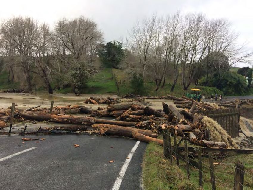
gently rolling hills (Leathwick et al 1995). These rocks are easily weathered, yielding large
amounts of sediment as they are uplifted and then eroded. Also easily weathered are the
older mudstones that contain smectic clays, a band of which stretches across the upper
catchment and which are also found in mélange rocks in the lower catchment. Smectic clays
allow water to be absorbed so that layered rocks shear easily when water is present,
facilitating the formation of earthflows (Waimatā Project Report 1: Cullum et al, 2015). Most
of the Taruheru catchment consists of low hills and alluvial flats, built up through numerous
flood events.

The Waimatā catchment lies adjacent to a major tectonic boundary. Off shore, the Pacific
Plate is moving under the Indo-Australian plate at the Hikurangi subduction margin at a rate
of up to 6cm a year (Wallace et al, 2009) so that faults and earthquakes are common and
uplift rates are high (Cullum et al, 2015). The combination of tectonic activity and soft rock
means the East Cape region has some of the highest sediment yields per unit area in the world
(Hicks et al 1996) The Waiapu and Waipoa rivers generate 35 megatonnes/year (0.2% of the
global yield) and 15 megatonnes/year (0.1% of the global yield) respectively. Although
sediment yield from the Waimatā is relatively low compared with these rivers, it is still high
compared to other catchments in New Zealand. Since the Last Glacial Maximum (LGM)
sediment yield of the Waimatā has been estimated at 2.6km3, most of which has been
transported by river to the ocean (Cullum et al, 2015). These geological processes are
fundamental to the sedimentation issues facing the East Coast.

                                                                                            3
Map 1.1. The extent of the Waimatā Catchment and adjacent catchments within the Gisborne Region.
The overlay transparency allows for the identification of the main plantation forestry blocks, pasture,
and small pockets of native forest. (Source: Tairāwhiti Planning Maps, GDC 201)

    2. Soil, landscape and Geomorphology

In addition to ongoing tectonic subduction, the Waimatā catchment bears the imprint of
changes in sea level associated with long term climate changes in the Pleistocene era. The
landscape now bears the imprint of the associated multiple cycles of erosion and deposition
(Cullum et al 2015). As a result, flights of terraces border almost the entire length of the river.
These terraces resist erosion, effectively confining the course of the river to a fixed position

                                                                                                     4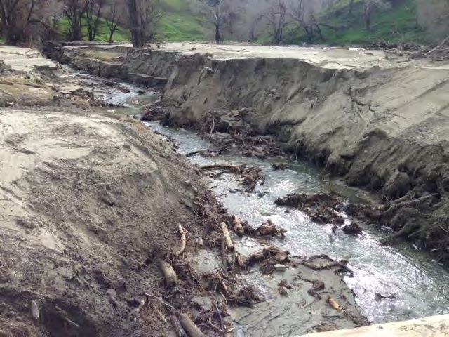
in narrow valleys with little space in which sediment is stored (Cullum et al, 2015). Sediment
that enters the river thus tends to aggrade the river base or flow downstream out to sea.

Landscape types in the Waimatā and Taruheru catchments are defined in terms of valley
morphology, hillslope, gradient and geology. Landscape types in the Waimatā catchment
begin with steep headwaters, which are characterised by narrow v-shaped valleys with high,
steep sides. From the headwaters the river moves through several other landscape types as
it flows toward the sea. These are the earth flow regions, followed by finely dissected steep
terrain, low relief steep terrain, the lowlands and the low relief terrain of the Taruheru
catchment. The final two landscape types that characterise the Taruheru catchment are the
Poverty Bay flats and finally the coastal plains. Detail on each of these landscape types can be
found in Cullum et al (2015).

The soils which have formed on these different types of terrain vary considerably according
to the underlying geology and the steepness of the gradient (Gibbs, 1959). Those within the
Waimatā catchment are largely defined as steepland yellow-brown earths, while to the east
the more gently sloping land has formed yellow-brown earths and to the west in the Waipaoa
valley there are series of alluvial soils. Alluvial soils on the flats comprise well-drained recent
soils on levees and poorly drained gley soils on the backswamps of the flood plain. A zone of
saline gley soils associated with estuaries is present near the coast (Clarkson and Clarkson,
1991).

   3. Flora

The Waimatā river and its catchment run across two ecological districts, with the headwaters
and 80% of the catchment lying in the Waiapu ecological district, and the southern 20%,
where the river meets the sea, lying in the Tūranga ecological district. Both of these districts
lie within the Gisborne Botanical Province (Wardle, 1991).

Characterisation of an ecological district depends on the topography, geology, climate, soils,
vegetation and human-induced modifications of the area (Nicholls, 1979). An ecological
district is a localised part of New Zealand where the topographical, geological, climatic, soil

                                                                                                 5
and biological features, including the broad cultural pattern, produce a characteristic
landscape and range of biological communities (Park et al, 1983).

The two ecological districts spanned by the Waimatā have varying types of geology, soil and
vegetation but it is the difference in their topography that is immediately obvious. The finely
dissected, moderately steep hills of the Waiapu Ecological District contrast strongly with the
low hills and alluvial flats of the Tūranga District.

Singers and Lawrence (2016) used an ecosystem classification tool developed by the
Department of Conservation (Singers and Rogers, 2014) to map the predicted pre-human
ecosystems of the Gisborne District (Map 1.2.). This tool amalgamates previous classifications
and ecological studies aligned to an abiotic framework. Although most of the coastal forest in
the district had already been cleared by Māori when the first European settlers arrived, and
this was followed by an almost complete removal of the original forest cover in the Waimatā
catchment, it is possible to reconstruct the general nature of the pre-human forest cover from
the remnants that survive, along with historic descriptions (Leathwick et al 1995).

Stanley Tait, a bush feller and fencer in the region in the early 1900s, provides one of the
most vivid descriptions of the native bush and waterways in that period:
        Steep hills and river flats were bush-covered right down to the beds of the rivers which
        were hard and full of huge boulders. The water was clear and sweet and it ran fast.
        Children swam in the clear pools, and there were eels, native trout and fresh water
        mussels. The native bush was beautiful. It was full of tawa, with plenty of tōtara, white
        pine and matai. There was beech forest at the higher levels. There were pongas and
        ferns of all sorts, and the under- growth was thick and green (Coombes, 2000, Pg. 11).

                                                                                               6
¯

                                                      Legend

                                                      Proposed_terrestrial_ecosystem_waimata
                                                      Ecosystem Type (feature count)

Map 1.2. The Proposed (Pre-human) Terrestrial Ecosystems of the Waimatā Catchment indicating that
tawa, Kohekohe, titoki, podocarp forest dominated. (Singers and Lawrence, 2016).

                                                                                               7
Predicted vegetation for the catchment reflects previous assessments (Leathwick et al 1995),
with some finer division of several ecosystems. Forest in the Waimatā catchment was largely
comprised of tawa (Beilschmiedia tawa), kohekohe (Dysoxylum spectabile), titoki (Alectryon
excelsus) and podocarp forest, typical of moderate to steep hill slopes in lowland and
climatically warm areas which experience little frost. Kohekohe was less dominant higher in
the northern headwaters of the catchment, and the mix of species changed inland, and with
the increase in altitude. Some kohekohe remained along with pukatea (Laurelia novae-
zelandiae) rewarewa (Knightia excelsa), scattered northern rāta (Metrosideros robusta) and
hinau (Elaeocarpus dentatus), all overtopped by emergent conifers – kahikatea (Dacrycarpus
dacrydioides), rimu (Dacrydium cupressinum), matai (Prumnopitys taxifolia), tōtara
(Podocarpus tōtara), tānekaha (Phyllocladus trichomanoides) and/or miro (Prumnopitys
ferruginea) (Leathwick, 1995). Patches of kāmahi (Weinmannia racemosa) dominated forest
with tawa, podocarp and mixed beech (Nothofagus), (or rāta in more humid locations) also
featured on the moderate to steep hill slopes at the head of the catchment.
On the alluvial river terraces of the upper catchment, tall forest of emergent kahikatea over
a canopy of tōtara and matai dominated. This ecosystem also featured black maire (Nestegis
cunninghamii) white maire (Nestegis lanceolate), titoki, tawa, small leaved kōwhai (Sophora
microphylla), narrow leaved lacebark (Hoheria angustifolia), houhere (Hoheria polulnea) and
a range of divaricating shrubs. This ecosystem type primarily occurs on alluvial terrace
landforms with recent brown, raw, allophanic and pumice soils, and may have been much
more widespread on shallow hillslopes prior to human occupation.
In the top half of the lower catchment on the poorly drained, gley soils of the flat alluvial
terraces and forest wetland margins of the valley floors, kahikatea-pukatea forest was
dominant. Patches of emergent kahikatea-pukatea forest with abundant tawa and titoki
occur exclusively within valley floors with “imperfectly drained” or “mottled” soils such as
recent fluvial mottled (RFM). The moderately well drained recent alluvial soils of the
remainder of the lower catchment supported forest dominated by pūriri (Vitex lucens), (once
common on the east coast) and tōtara. The vegetation then changes back to kahikatea-
8pukatea forest (with intermittent pūriri) in the final stages of the river’s descent to the Poverty
Bay flats, where it joins with the Tūranganui river and flows out to Poverty Bay.
The Tūranganui catchment is located entirely on the Poverty Bay flats, with the river itself
running east of Gisborne city. Pollen cored in Gisborne city suggests that the vegetation
during the last 40,000 years was similar to that found in surviving forest remnants (McGlone
et al, 1984). Plant species collected first by Banks and Solander (1769) and then other
collectors including Henderson and Ongley (1920) on the Gisborne flats suggest that they
were dominated by kahikatea, mainly growing with pukatea on the poorly drained soils
(Clarkson and Clarkson, 1991). Other ecosystem types would have existed in various
topographical units of the coastal area where the Tūranganui meets the sea. These would
have included swamp mosaics on the flats immediately behind the fore dunes of pīngao
(Ficinia spiralis) and spinifex (Spinifex sericeus), then dune forest of tōtara, kānuka (Kunzea
ericoides) and broadleaf. Estuarine rushland herbfield is also likely to have been present.
A variety of vegetation would have occurred in disturbed areas throughout the catchment.
Erosion-exposed soils would have been colonized by pioneer woody species such as tutu
(Coriaria arborea) and kōwhai (Sophora sp.) and small tree species like kohuhu (Pittosporum
tenuifolium). After fire, kānuka and/or mānuka (Leptospermum scoparium) would have been
the initial colonisers often accompanied by tuahinu (Ozothamnus leptophyllus) and bracken
(Pteridium esculentum).
4. Fauna
In both the Waimatā catchment and the wider Gisborne District, all indigenous groups of
fauna would have been present. Numerous bird species would have colonized the forest
(kokako, kākāriki, whitehead, huia, kākā, kereru, kiwi), the coast (dotterel, tern, stilt,
oystercatcher, heron) and wetlands (rails, mātuku, crake, fernbird), and included several
species of the extinct moa (Leathwick et al, 1995; Clarkson & Clarkson, 1991) Seabird colonies
would also have been plentiful across the coastal part of the district and many species of bat
(including the now extinct greater short tailed bat), lizard, frog (Hochstetter’s) and
invertebrates would have been present. Māori tradition describes the presence of moa, the
9extinct eagle and tārepo (wingless goose) in the district. Tuatara would have been plentiful
on the hills, as evidenced by the numerous bones in Māori middens at Wainui (Clarkson &
Clarkson).
A quote from Coombes (2000) indicates that while local Māori were predominantly a coastal
people, they were also highly dependent on forest resources, collecting different resources
during their seasonal migrations. As one kaumātua noted;
Here [at Mangatu kāinga] there were tuna [eel] in the river, but the people were a
long way from the sea. The way I understand it, those people would go down to the
sea in summer and. fish and eat hard out for a while. For most of the year, though,
they were dependent on finding food from the bush. Pigeons were eaten in great
number, but the [Polynesian] rat was a very important food source. If we couldn't have
caught rats and pigeons from the bush, it would have been hard for the community
like there was here to have survived.
5. Freshwater
It is difficult to determine the ecological state of freshwater in the Waimatā catchment prior
to human habitation. By examining the state of a reference site in the region with similar
geology and a relatively unmodified catchment, we may get some indication of the pre-
human freshwater biodiversity of the Waimatā.
According to Gisborne District Council Freshwater ecologist Harriet Roil, one such site is the
Waihirere stream in the Waiherere Domain. This site, which is located at the head of the
Taruheru River, has been used by Gisborne District Council as a reference point for the
biodiversity of the Waimatā river. The stream shows a rich abundance in Ephemeroptera,
Plecoptera and Trichoptera (EPT) (commonly known as Mayfly, Stonefly and Caddisfly)
populations (Roil pers comm, 2018). EPT taxa are generally intolerant of pollution so the more
found in a sample, the better the stream health. It is likely that the Waimatā would have
supported a diverse range of EPT taxa prior to human colonisation. EPT taxa feed on
periphyton and detritus within the water column, keeping organic matter levels down and
water quality high. They would also have provided a plentiful food source for inhabiting fish
species.
10The Waihirere stream data also indicates that freshwater fish species in the Waimatā would
have been highly diverse, and likely to have included now-threatened species such as the
giant kokopu, banded kokopu and potentially the lamprey and Short jaw kokopu. Other
species present would have included the Longfin eel, Koaro, Torrentfish, Inanga and Bluegill
bully. The more common Crans bully, Shortfin eel, Black Flounder, Mullet, Goldfish and Smelt
would also have been present.
Kakahi or freshwater mussels are also found in the Waimatā catchment. Kakahi, which are
well known for their filter feeding techniques, use native fish to assist in their life cycle and
improve their distribution tactics.
Section Two: Human impacts on pre-human biodiversity
1. Māori settlement and the impact on the pre-human environment
Tribal history in the bay in the bay is complex, but well documented. Salmond (1991) and
Halbert (1999) discuss three main groups of migrants known to have arrived in Tūranga-nui
in about the 1300’s. One early migration to the East Coast is associated with Paikea, who
came to the East Coast from Hawaiki in the shape of (or riding on) a whale. Another group
came on the canoe Horouta, which was captained by Paoa. The high priestess of this canoe,
Hine Hākirirangi, is said to have introduced kūmara to the region. Around the same time, the
sacred canoe Takitimu arrived from Hawaiki, bringing tapu axes and stones and a number of
gods. According to some accounts, its captain Kiwa planted a mauri in Tūranga as a link
between people and the land, while its chief priest Ruawharo established a house of learning
called Tokitoki at the bay. The two names alternately given to the district, Tūranga-nui-a-kiwa
and Tūranga-nui-a-rua (Kiwa or Rua’s great standing place) recall a contest of mana between
Kiwa and Ruawharo. The final migration was that of the ancestor Maia, who quarrelled with
Uenuku in Hawaiki and escaped by sailing to this country on a raft of gourds.
Voyagers on board these vessels set up camp ashore as the extensive native forest was rich
in resources, and the ocean and rivers provided plentiful food and water supplies. Māori kin-
11groups who settled in the region included Ngai Tamānuhiri, Ngāti Porou, Ngāti Rākai,
Rongowhakaata, Te Aitanga-ā-Māhaki and Te Aitanga-ā-Hauiti. These tribes often used the
Taruheru, Tūranganui and Waimatā Rivers as boundaries, and also Te Toka-ā-taiau, a sacred
rock which was located in the Tūranganui River (Reeve, 2015). Kin groups often intermarried,
however, creating bridges of kinship and alliance. Te Wai-o-Hīharore, a small coastal area
between the Waikanae stream (the site of many eel weirs) and Te Oneroa beach (where
fishing nets were cast and pipi were collected) on the western mouth of the river, was set
aside as a fishing camp where in times of war, inland kin groups could safely go to fish. This
was used by all of Te Aitanga-ā-Māhaki. A freshwater spring on the site flowed under the
beach into the sea, attracting kahawai (Waimatā Project Report 2: Salmond and Phillips,
2015).
The Waimatā River also served as an inland highway linking Tūranga to the East Coast,
especially Whāngārā and Uawa. Those who lived on the North, West and East Waimatā blocks
had close relationships with Ngāti Konohi at Whāngārā and Te Aitanga-ā-Hauiti at Uawa. It
was also used as an escape route during the inter-iwi wars from 1700-1800, and the upper
reaches of the river served as a refuge (Salmond and Phillips, 2015).
The higher slopes of the rugged hills of the Waimatā catchment were not suitable for
cultivation and settlement, but provided forest resources of timber, fruits, kiekie (Freycinetia
banksii) for weaving and birds and invertebrates for food. The introduction of the kuri
(Polynesian dog) and kiore (Polynesian rat) had impacts on the indigenous fauna, especially
ground-dwelling lizards and birds, while many birds were also hunted for human
consumption. Some ridgelines provided pathways to link the coast with inland resources, but
the coast would have provided quicker transport from the settlements in the eastern bays
around to Poverty Bay. The waterways provided eeling grounds and, where slightly swampier
ground existed, sources of flax/harakeke (Phormium tenax and Phormium cookianum) and
raupō (Typha orientalis) used for making fishing nets, baskets and many other necessary items
(Reeve, 2015).
From maps developed for the Māori Land Court in the 1870s and 1880s, the middle and upper
reaches of the Waimatā catchment appeared to be largely in bush, with some minor
12clearances along the ridges (to provide tracks and unimpeded views) and the lower reaches
of the river. This bush was probably cleared for construction materials or to clear land for
kūmara fields or fern-root diggings, as suggested by the archaeological evidence.
Archaeological sites have been recorded only in some parts of the lower catchment. These
appear to be grouped either close to the river itself in the middle and lower reaches, or along
the higher ridgelines overlooking the Waimatā River. Most of the sites appear to be pit and
terrace sites, suggesting that there was some cultivation of kūmara where there were small
river flats with suitable soils.
Permanent occupation was concentrated near the mouth of the river, in the lower reaches,
where the hills were less steep and the river flats were made of rich alluvial soils (Salmond
and Phillips, 2015). Here, the bush was largely cleared and a full range of settlement types
(pa, kāinga, garden and camp sites etc) was found. The damage to rivers was minimal as they
were taonga to Māori (Reeve, 2015) The area around Awapuni lagoon, Waikanae river mouth
and Tūranganui was used for catching eels, freshwater mussels, crayfish and whitebait and
flounder. Māori recall rivers at the time being particularly abundant with eels, but swamps
also provided other food sources such as moa, weka, pūkeko, kiore and fern root. Maps
prepared for Waitangi Treaty claims by Aitanga-ā-Hauiti and Aitanga-ā-Māhaki show a
division of the rohe centred on Tūranganui and the lower reaches of the Waimatā. Much of
the middle reach and all of the upper reach of the Waimatā, as well as other hill country to
the north-west, were claimed by both iwi (Salmond and Phillips, 2015).
2. European settlement and the impact on the natural environment.
The arrival of Captain Cook and his crew on the Endeavour in Tūranganui in October 1769 was
a precursor to the European settlement and colonisation of the region. The visit itself was
short-lived, with the Endeavour and its crew leaving just two days after their arrival.
Misunderstandings between Māori and Captain Cook led to violence and the death of a
number of Māori. Cook renamed the area Poverty Bay as it afforded him and his crew “no
one thing we wanted” (Reeve, 2015), most likely because they were unable to access fresh
water and food due to clashes with the local inhabitants (Salmond, 1991). During this short
visit however, Royal Society scientists travelling on the Endeavour, Joseph Banks and Dr
13Solander, made extensive plant collections (Salmond, 1991). Although the specimens were
from coastal areas and Poverty Bay itself rather than inland, their collections demonstrate
the diversity of plants present in the district, many of which are now highly threatened.
Because the scientists’ explorations were limited to the coastal zone, these threatened
species tend to be wetland and sand dune plants and small herbs which favor highly disturbed
sites where exotic weeds now dominate. Other notable botanists who later visited the area
included William Colenso and Thomas Kirk, who wrote that “The extensive forest districts
exhibit great variety and luxuriance” (Kirk, 1897).
In the wake of the Endeavour, traders, whalers and missionaries arrived in Poverty Bay,
trading resources such as blankets, flax, firearms and tobacco with local Māori. Following the
East Coast War and Te Kooti raids in 1865-66, a town was planned and built. The name of the
town was changed from Tūranganui to Gisborne after the Honourable William Gisborne, the
Colonial Secretary in Britain at the time (Reeve, 2015). Forest close to town was felled for
firewood or burned. An account by E.F. Harris in the 1870’s remarks that any remaining bush
on the flats was soon gone, “especially Tawa” was “felled for firewood and burned mostly by
residents of Gisborne”. He recalls Whakawā, “another fine white pine bush” which adjoined
other large forest areas such as Opua station where “numerous clumps of Kōwhai some 30
inches in diameter” could be found, and on his own land “white pine [kahikatea] trees close
on five feet through. (Times Jubilee Handbook, 1927), all of which was soon burned by the
settlers.
As land went through the Native Land Court from the 1880s, there was increased European
settlement in Poverty Bay, and with this came the large-scale clearance of native forest to
make way for pastoral agriculture. Gundry (Waimatā Project Report 3: 2015) gives a detailed
account of these changes in land use and their impact on the Waimatā, based on extensive
research into contemporary photographs, newspaper reports and other sources:
“The meat and wool boom began in 1890 and high external stock prices and the fertile alluvial
soils in the Waimatā catchment made agriculture an easy choice for income. Swim dips and
killing houses were built on stringers over the waterways so that waste and sheep dip could
be quickly disposed of . This had a major impact on freshwater life in the river.”
14“Land blocks in the Waimatā catchment were purchased and new owners set about clearing
the heavy bush to clear pasture for sheep. Many hundreds of acres were cleared, providing a
wealth of work for bush fellers over the next two decades with at least 3000acres felled in
the catchment in 1901 alone. On 18th December 1895 The Poverty Bay Herald reported:
The Burning of bush, fern and grass is now being carried out in various parts of the
district and the consequence is that the air around the town is charged with
smoke….Some fours thousand acres of bush country were cleared by fire in the
Waimatā district yesterday, a good burn being obtained.”
By the end of the nineteenth century, almost all of the kahikatea swamp forest and wetlands
of the Poverty Bay flats had been drained and little forest remained on the surrounding hills.
Large scale removal of forest had a drastic effect on the region’s wildlife. E.F. Harris (Times
Jubilee Handbook, 1927) recalled that in 1873, Poverty Bay had been an ideal spot for
sportsmen. Pigeons [kereru] and Kaka were numerous and were able to be shot “off his horse
“with “20-30 pigeons easily attainable”. Ducks (probably a mix of endemic and introduced
species) were to be found in large numbers in all the rivers, and from Harris Bend on the
Waimatā river right up to its source they were also plentiful. “Parakeets (Kākāriki) used to
come to the flats in their thousands; their last visit was in 1875”, presumably when the last of
their habitat was destroyed. These recollections provide an indication of the sheer volume of
bird life that existed and how quickly and dramatically their numbers declined with the large
scale and comprehensive removal of habitat.
Deforestation of the region continued, and headed inland. From 1880 to 1920 the hill country
was extensively cleared through logging and burning for conversion of land to pasture for
sheep and beef. During this period, native beech and podocarp broadleaf forest cover on the
East Cape was reduced from an estimated 68% to 23% of land area (Ewers et al, 2006) Further
clearance was encouraged by government-led initiatives in the 1960s and 1970s that provided
subsidies for land development fertilizer grants, reduced loans, and guaranteed minimum
livestock prices. (Rhodes, 2001). Native podocarp forest now accounts for only 2.5% cover of
land in the region (Cullum et al 2015). Much of the region is now in pasture [40%], exotic
plantation forest [19.3%] or regenerating mānuka / kānuka scrub [9.1%] (Fig.2.1).
15Section 3: Current State of Indigenous Biodiversity in the
Waimatā Catchment
1. Effects of changing land uses on Geomorphology of the river
After a flood on March 11 1880, Henry Dods of Linburn station in the Waimatā catchment
(1892) remarked that “no one with his eyes open can fail to see that denudation of the hills
is enormous, they are scarred with thousands of slips and although most of these do not
descend directly in to the river they are left as masses of loose soil on the hillsides and every
flood carries a portion of them down to the stream. I have seen slips of 6000 and 9000 cubic
feet slide from ground level into the river …” (Gundry, 2015).
It didn’t take long after the bush began to be cleared in the Waimatā Valley until the effects
were felt downstream, with flooded land and homes, slumped riverbanks, damaged or
destroyed bridges, harbor siltation and driftwood clogging the river, bridges and beaches. In
her report, Gundry (2015) quotes many observations made by farming families in the valley.
According to Howard Kenway, for instance:
Slips of considerable extent bear witness to the enormous quantity of water which
poured down the hill sides. Messrs Richardson Bros' swing bridge, which was several
feet above the last big flood, was swept away… Taking bush off the catchment made
floods higher with the same rainfall. …Two bridges and a wool shed were carried away
in July 1927 after a cloudburst in the valley that saw the river rise 35 feet at Savage’s,
20 miles from Gisborne. Drover Jack Robb’s house was washed from its foundations
and wrecked; stock were lost. The bridge below the store was washed away and
rebuilt as a suspension bridge. A composite girder bridge was built in its place in 1959.
In the 1927 flood, the steel superstructure of Kenway’s Bridge – the largest bridge on
the Gisborne-Waimatā Road – was swept off its piles. Water lapped the bridge deck
in the September 1930 flood and the bridge was raised five and a half feet.
The extensive and rapid deforestation of the region had devastating effects on both
indigenous species, with the removal and modification of their habitat, and the wider
environment in the Waimatā valley. The combination of weak lithology, steep slopes resulting
from tectonic uplift and incision, high rainfall, frequent storms, and recent forest removal
makes this landscape exceptionally prone to erosion, generating and delivering huge
quantities of sediment to river systems (Cullum et al, 2015). Even before the arrival of
16humans, the landscape bore the imprint of multiple cycles of erosion and deposition
associated with climate changes over millennia.
As Cullum et al have noted, flights of terraces border the banks along almost the entire course
of the Waimatā river (Cullum et al 2015) These terraces resist erosion, effectively pinning the
course of the river to a fixed position (Fryirs et al 2016). The Waimatā river thus acts like a
chute, with much of the sediment and woody debris that enters the river being swept
downstream and out to sea (Cullum et al, 2015). Deforestation has exacerbated the rate of
erosion and local geologist Mike Marden notes while there is conclusive evidence to show
that forests slow down the rate of earth flow displacement, when there has been rainfall over
a long period the soils become very wet, and forest cover is not always able to prevent slopes
from failing. A mature forest can at best slow the rate and amount of downslope
displacement, particularly of earthflows, and thus reduce the amount of sediment delivered
to river channels. (from Gundry, 2015).
Each period of deforestation, from first Māori settlement to early European settlement and
the more recent clearing of plantation forests has been followed by extensive hillslope
erosion as soils are no longer stabilized by tree roots, and run-off increases as less water is
intercepted and transpired by trees (Marden et al 2012). Across the region, responses to
deforestation have been widespread, including floodplain sedimentation, widening of
downstream channels due to sediment scouring and aggradation of channel beds.
2. Deforestation and conversion of land for agriculture
By 1920 much of the region’s native forest had been removed, largely by logging and burning
for conversion to pastoral farming, with remaining vegetation strongly biased towards higher
altitudes. Of the 23% of the region that remains in native forest (LCBD, 2014), these areas
tend to be isolated, restricted to steep hillsides and largely consisting of secondary regrowth
forest dominated by kānuka (Clarkson and Clarkson, 1991). Early successional scrub of young
mānuka and kānuka makes up another 9% of the region. (Fig.2.1.). Podocarp and
tawa/broadleaf forests of the lowlands and foothills fared the worst, with more than 85% of
the original landcover cleared. The regenerating scrub and shrublands that remain do not
17represent the ecosystems that once dominated the foothills and lowlands. The remaining
intact forest on the plains totals only around 25ha. The most threatened ecosystem in the
region is wetlands with only 1.75% (1,487.23ha) of their original extent (84,765.16ha)
remaining (LCBD, 2014)
The Waimatā catchment did not escape the destruction of the forest, as first the low hills and
then the steeper, more finely dissected areas were cleared for conversion. While the
catchment was once predominantly clothed in primary forests of tawa, titoki, kohekohe and
podocarp (Singers & Lawrence, 2017) these now cover just 6% of the catchment (Map 2.1.)
with alluvial terraces of kahikatea-pukatea forest now almost all but absent. The current
catchment is dominated by pasture and exotic pine plantations. High-producing exotic
grassland makes up around 50% of the catchment area (Fig.2.2.), higher that the regional
cover of 40%. The second highest land cover unit, exotic pine (Pinus radiata) plantation
forest, sits at around 28% cover, nearly 10% higher than the exotic forest cover across the
Gisborne region as a whole (19.3%). Indigenous scrubland/secondary forest of mānuka
and/or kānuka covers 11% of the catchment, similar to the estimated regional cover of 9.1%.
Pockets of indigenous forest are scattered throughout the catchment, with larger areas
towards to the west and north. Together these cover 6% of the catchment, compared with
an 23% of indigenous forest cover for the region. The remaining 5% landcover in the Waimatā
catchment is a mix of exotic vegetation, open water/river, horticulture and built-up areas.
18¯
Legend
Waimata_Catchment
Waimata_LCDB4
Name_2012
Broadleaved Indigenous Hardwoods
Built-up Area (settlement)
Deciduous Hardwoods
Exotic Forest / Forest Harvested
Gorse and/or Broom
Gravel or Rock
Herbaceous Freshwater Vegetation
High Producing Exotic Grassland
Indigenous Forest
Lake or Pond
Low Producing Grassland
Manuka and/or Kanuka
Orchard, Vineyard or Other Perennial Crop
River
Short-rotation Cropland
Urban Parkland/Open Space
Map 2.1. Different landcover types for the Waimatā Catchment. Source: New Zealand
Landcover Database V.4:
19Low Producing Indigenous Forest
6% Built-up Area
Grassland Deciduous (settlement)
2% Hardwoods 1%
2%
Manuka and/or
Kanuka
11%
High Producing
Exotic Grassland
50%
Exotic Forest /
Forest Harvested
28%
Figure 2.2. % cover of the different landcover classes in the Waimatā Catchment (LCBD, 2014).
Several other land classes have been excluded as their sum total wasLandcover types reflect the current land uses in the Waimatā catchment, with most of the
land in high production grassland for sheep and beef farming. Planting of the Waimatā in
exotic forestry did not occur until 1960, when the first exotic plantation forest was established
in the Mangatū block (Mike Marden pers comm, 2018). Further planting occurred later in the
headwaters of the catchment, mostly during the 1990’s after Cyclone Bola, where planting
focussed on erosion control. The Gisborne District Council identified the worst areas of
eroding land as Land Overlay 3a that should be planted with effective tree cover by 2021,
with most of this being exotic pine planting. Funding was (and still is) available through the
Ministry for Primary Industries' Erosion Control Funding Programme. Most of the native
vegetation that remains is on very steep land unsuitable for farming, where the forest was
left intact, while some mānuka/kānuka scrub is a result of reversion from farmland to prevent
erosion, or areas that have been protected for their biodiversity value.
In total, the remaining indigenous land cover in the catchment is approximately 17%
(including mānuka/kānuka). The largest of these areas is at the head of the catchment and is
made up of public land (Whakaroa Reserve) and private land. Here, remnant forest of tawa
and black beech are mixed with regenerating mānuka-kahikatea forest with emergent
rewarewa and an understorey of five-finger, kāmahi and tree ferns. Tawa forest is the most
common type of indigenous forest remaining (with the exception of mānuka/kānuka), often
growing with kohekohe, kānuka, titoki, and/or kahikatea on the flats. Black beech occurs
occasionally (GDC, 2006).
Nearer to the ocean, land in the catchment has been converted to lifestyle and horticultural
blocks mixed with farmland, and then suburban dwellings and parkland, and where the river
flows into the Tūranganui river and out to sea, urban shops and dwellings, and Gisborne port.
Most of the older trees planted along suburban roads, in gardens and in parkland are exotic,
although in more recent times there has been an increase in planting native species. As it
approaches the sea, the river has been extensively modified, with artificial banks constraining
its channel, large scale bridges and major engineering works (including diversion of the river
at ‘the Cut’, reclamation and regular dredging). Further reclamation is currently being
discussed.
21With less than 50% of the Waimatā catchment now in exotic or native forest cover, the
overland flow to the streams and rivers has increased in historic times, with larger volumes
of water travelling across exposed land to the river, carrying with it sediment, nutrients and
woody waste from the land. For each 1000mm of rain that falls, 300m is intercepted by the
forestry canopy and 300m is transpired through the root system, reducing the rainwater to
the river by 60%. (Marden et al, 2012). Without forest cover, close to the full 1000mm end
up in the river. As exotic forests are harvested, the volumes of water flowing into the Waimatā
River increase proportionately, carrying sediment and forest debris into the river. This can
have significant impacts downstream on farmland, urban areas, the city and port.
3. The condition of Protected Management Areas (PMA’s) and other forest remnants.
Much of the additional remaining indigenous forest in the Waimatā catchment (2.7% of the
total catchment area) has been identified as Protected Management Areas (PMA) under the
Gisborne District Council’s District Planning process. Protected Natural Areas are the outcome
of surveys by DOC in the 1980’s under the Protected Natural Area Programme (PNAP). A
subset of the most ecologically significant sites was then included in the Gisborne District
Council’s District Plan accompanied by a set of objectives, policies and rules to ensure a
greater level of protection of these sites from modification and removal. For example, the
removal of vegetation from PMAs requires a consent if clearance exceeds 500m2 in any
contiguous area and/or exceeds 500m2 over any 12 month period (removal of up to
500m2/year is permitted). Removal by grazing is not controlled, however; and there is limited
support for pest and weed control in these areas.
The largest of the PMA’s is Hiriwoa Kānuka bush (WR79,) a combination of Whakaroa Reserve,
a Department of Conservation Scenic Reserve, and private land. This is followed in size by
PMA WR62 off Cave Road, a 197ha kānuka-dominated bush with tawa and kohekohe in the
gullies. Other larger PMAs in the catchment include Waikomo Stream bush 62ha (WR52) and
Riverside Road 29ha (WR63), both of which are dominated by tawa and kohekohe with titoki
and kahikatea. In addition, Waikomo has some pūriri which is relatively uncommon in the
catchment as distance from the coast increases, and pukatea. The remaining PMA’s are
dominated by Tawa, kohekohe, titoki, kahikatea forest, however a couple of sites are
22dominated by regenerating podocarp forest of rimu, miro, tōtara and kahikata (GDC, 2006,
McClean, 2018).
A recent survey of PMAs by Gisborne District Council (McClean, 2018) in the catchment area
found that those in the lower part of the catchment tend to be smaller and contain more
weeds. There were however some exceptions including Riverside road (WR63 - Longbush)
which is relatively weed free, and Cave Road (WR62) which is relatively large (>100 hectares).
The survey found that in the upper part of the catchment, PMAs tend to contain a lower
diversity of weeds. A number of PMAs in and around the Utting road area of the Waimatā
catchment have been fenced by landowners to exclude stock. Where fenced, understorey
regeneration tends to be rapid due to favourable natural factors including mild temperatures
(few frosts), reasonable rainfall (over 1500mm) and good natural soil fertility. In addition to
fencing, some landowners have been pro-active in managing plant and animal pests. One
landowner who owns a large PMA dominated by secondary forest has been controlling
wilding pines by ground and aerial means for several years. In the lower part of the catchment
several PMA’s have been managed intensively for a wide range of animal and plant pests over
the past decade (e.g. Gaddums Hill and Longbush).
Gundry (2015) describes some remnant bush areas within the catchment;
On Waikereru Station stands one of the biggest Kahikatea in the country, at one time
described as 49m high and over 1000 years old, with its base covering nearly half a
tennis court. According to Bruce Holden, his grandfather Thomas Holden left a lot of
patches of bush on Rimuroa during its clearance. Today, Ngahiwi has about 80 acres
of original bush, predominantly kohekohe, rimu, rewarewa and pūriri. None of these
areas is protected by a QE2II covenant.
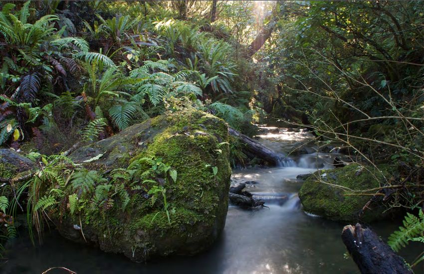
In a recent survey of lower Waimatā riparian vegetation (Forbes et al, 2018) a total of 457 ha
of the Waimatā River riparian zone approximately 14km upriver was surveyed. 67% (308 ha)
of this section of the riparian zone was forested, with exotic forest making up 78% (239.3ha)
of the total forested area, the remaining 22% (68.9 ha) of forests being predominantly native
(Table 3). More than half (63%) of the forested area was grazed. Treelands (canopy cover of
20-50%) covered 62.5 ha and shrublands, with rushlands and grasslands each forming
23relatively minor components of the riparian zone vegetation structure. Riparian vegetation
varied spatially along the river, although this was generally scarce below Goodwins bridge.
Fresh goat sign was detected at 42% of native sites and the abundance of goat sign was
positively associated with understorey browse severity. The co-occurrence of these variables
indicated that goats are retarding the regeneration of some native forest areas. A quarter of
all sites had common fresh sign of stock with occasional stock being seen or heard at those
sites. In most sites (61%) stock sign was uncommon and often old or only occurred near forest
edges. Forty percent of old growth sites showed no sign of stock presence.
Photo 3.1. Longbush Reserve (left) bordering the Waimatā River with a QEII covenant on the
Hoogerbrug property (right) opposite. (Photo: Adam Forbes).
Other forms of legal protection
Areas protected by Ngā Whenua Rāhui kawenata (NWR) or Queen Elizabeth the Second
covenants (QEII) include 13 Covenants in the Waimatā catchment, covering 313 ha and
ranging from 0.36ha to 105.1 ha. Covenanting under the QEII trust means that the land and
its biodiversity values (e.g. wetland, indigenous bush etc) are legally protected from
24modification (other than what is agreed between the landowner and the Trust) in perpetuity.
In these covenants, bird species include whitehead, and new Zealand falcon. Plant species
present include jovellana sinclairii, many of the now (officially) threated Myrtaceae including
the following; Lophomyrtus obcordatum Metrosideros colensoi, Metrosideros perforate,
Metrosideros diffusa, kānuka and mānuka. Orchids including Drymoanthus adversus, Earina
mucronata, Earina aestivalis, Earina autumnalis, Gastrodia sp., Microtis unifolia, and various
Nematocerus and Pterostylus Thelymitra species are also present.
One of these QEll covenants,“Rimunui” on the property of the Hoogerbrugs, which is fenced,
covers 30ha across the river from Longbush. Ecologist Steve Sawyer describes this as one of
the best examples of coastal hardwood trees he has seen in the region – tawa, kohekohe,
pūriri, titoki, cabbage trees and kahikatea (Gundry, 2015). The Hoogerbrugs have fenced off
a similar-sized block near the boundary with Bruce Holden’s Ngahiwi station.
4. Biodiversity in production forest
Areas of indigenous forest within exotic forest plantations are reasonably common in the
catchment, and much of this forest is in relatively good condition. Malcolm Rutherford,
botanist and QEII representative for the Gisborne Region, has spent time in many of these
areas. He says these forest types are often modified primary forest with a canopy dominated
by either tawa, or kohekohe-titoki with occasional pūriri and pukatea present and pockets of
emergent podocarps. Steeper areas, often near stream sides, usually contain a broad range
of mixed broadleaf species, most likely as a result of being inaccessible to browsing mammals
such as goats and deer. One area in the upper headwaters of the catchment contains a ridge
of tānekaha (Phyllocladus trichomanoides), the only location for this species known in the
catchment. He says a relatively large area (65ha) of mature kānuka forest exists within exotic
forest in the centre of the catchment, with areas of cliff face vegetation, and other smaller
remnants of regenerating forest adjacent.
25Photo 4.1. A PMA site within a plantation forestry block. Photo: D. McClean.
Mr Rutherford says it is not uncommon to find a higher diversity of species in these areas due
to the absence of stock and the past control undertaken by forestry companies. Plant species
he has observed include the epiphytic Bulb Leaf Orchid (Bulbophyllum tuberculatum), the first
record in the catchment of this species. Other species of interest observed include the orchids
Earina autumnalis (Easter Orchid), Earina mucronata and the nationally threatened species
Jovellana sinclairii (NZ Calceolaria).
Mr Rutherford notes that some stream habitats are of reasonable quality within these areas.
He has observed high numbers of longfin eels of varying sizes and other species such as Cran’s
and Common bullies. Other fauna observed within these forest areas include whiteheads and
the NZ falcon.
As in much of the catchment, Kohekohe in the forest canopy is often heavily browsed by
possums, and the understory seems to be favoured by deer and goats, areas which are more
easily accessible are often quite bare. Where possum control is being undertaken understorey
vegetation is more common.
The recent survey of PMAs in the catchment found that remnant indigenous bush patches
within pine plantations are often in better condition than those in farmland, probably because
26of a combination of the lack of stock; goat and possum control being undertaken by the
forestry company; and the shelter provided by the pine trees. However this condition is often
dramatically reduced when and after the surrounding plantation forest is harvested.
5. The impact of pest plants and animals
The primary threat to Gisborne Region’s remaining biodiversity is from introduced pest plants
and animals. The effects of mammals introduced during both Māori colonisation (dogs – kuri,
and the Polynesian rat or kiore) and Europeans (possums, mustelids, rats, mice, cats, goats,
deer, cattle, sheep and pigs) have surpassed habitat loss by direct human removal, as the
greatest threat to biodiversity nationwide. Introduced species are having catastrophic, and in
many cases irreversible, effects on native fauna and flora. Their Impact has been two-fold.
Forests have been stripped of native vegetation, fruit and seed; and native fauna have been
predated, often to isolated populations or extinction. Exotic plants too have thrived in New
Zealand’s climate. Fast growing palms and shrubs often out-compete native species in
regenerating forest, vines proliferate, in some areas smothering whole kilometers of bush
and wetland, and aquatic species invade wetlands, rivers and lakes.
It can be assumed that in the absence of a strategic and sustained programme to control
introduced pest species at a regional or catchment scale, the majority of more common pest
animals are currently present throughout the Waimatā catchment. The most common pest
animals, and those most readily detectable in the catchment, are the browsing herbivores,
goats and deer (along with wandering stock); and the omnivorous possum. These animals do
the most damage to native forest vegetation and ecosystems. Ship rats (Rattus rattus), stoats
(Mustela erminea) and possums (Trichosurus vulpecula) are the most significant predators of
native species in the mainland forests of New Zealand (Brown et al, 2015). They prey on birds,
eggs, bats and invertebrates directly, while rats also eat seed. Presence of these pest animals
can lead to almost complete removal of the forest understorey, including the future seed
source, and drastically reduce birds, bat and invertebrate numbers.
In the Waimatā catchment, there are limited areas where pest plant and animal control is
being carried out. This includes several areas in the lower Waimatā where landowners, the
27Department of Conservation, Eastern Institute of Technology (EIT) and Gisborne District
Council are working collaboratively to restore areas of native bush on private (including
Waikereru Ecosanctuary) and public land (Donners Bush Reserve). This will be discussed
further in Section three. There is also some goat and possum control carried out in forestry
blocks in the catchment, and additional sites of possum control on a smaller scale throughout
the catchment.
6. The impact of indigenous vegetation removal
Current district plan rules allow for removal of early successional indigenous vegetation (e.g.
kānuka and mānuka forest) as a permitted activity as well as the clearance of up to 500msq
in each PMA annually. Since 2008 consent applications to the Gisborne District Council have
been granted to remove 2650.3ha of native forest. Of this, 1050.9ha was classified as
regenerating kānuka/mānuka; with the remaining 1599.4ha was classified as more diverse
regenerating or mature indigenous forest.
Of this 1599.4ha, 165.8ha was vegetation within Protection Management Areas. A selective
tree felling volume of 376m3 was also granted in the more diverse regenerating or mature
indigenous forest, 126m3of which was within a Protection Management Area. (GDC, 2016).
With only 17% of the catchment in indigenous cover, and just 15% of that (635ha, 2.75% of
the total catchment cover) in PMA’s, continued vegetation removal on this scale is having a
significant effect on the proportion of indigenous vegetation cover in the catchment.
7. Freshwater Biodiversity
Many steep headwater reaches of the Waimatā are currently in poor condition, being prone
to overloading by fine-grained sediments resulting from forest harvesting and land erosion.
Enhanced sediment loads also reduce local biodiversity and create a burden for downstream
reaches. The debilitating effect in ecosystems of large loads of fine grained sediment in rivers
is well documented. Water quality decreases and both fish and invertebrates tend to be less
abundant and less diverse in turbid river carrying heavy sediment loads (Cullum et al 2015).
Turbidity and bed sediment cover decrease food resources for aquatic creatures and the
28diversity of available habitat also decreases. Forest management practices and in headwater
reaches and earthflow activities in numerous tributaries have resulted in pulsed inputs of fine
grained material in to the Waimatā river.
Current data for the freshwater biodiversity of the Waimatā
Monitoring of the stream ecology has occurred since 2015-2016 summer period and
knowledge previous to this is sparse. There are four sites measured in the Waimatā
catchment and all four sites are in the River Environment Classification (REC), a database of
catchment spatial attributes summarised for every segment in New Zealand's network of
rivers. For the purposes of comparison, results are compared to those for the Waihirere
stream which is fed by a fully forested (native) catchment.
Information provided by Gisborne District Council shows that all four sites in the Waimatā
catchment have a lower %EPT and MCI score than the reference site at Waihirere stream in
the Waihirere Domain, (EPT stands for Ephemeroptera (mayfly), Plecoptera (stonefly) and
Trichoptera ( caddisfly), all species sensitive to water quality change. A high EPT is an indicator
of good stream health. MCI stands for Macroinvertebrate Community Index, an index which
measures the presence of macroinvertebrates for monitoring and reporting on stream health
in New Zealand). This indicates that the change in land use from indigenous forest and
development within the catchment has had a negative effect on water quality and a decrease
in species richness and abundance from the pre-human state. Makahakaha Stream is an
exception, with results being in the “Good” category (prior to forestry harvest in 2016). It is
known that stable, mature exotic forest can provide similar freshwater habitat to that of an
indigenous catchment (while trees are in situ) Pawson et al, 2010)
At the four monitored sites in the Waimatā catchment, the MCI index is in the “Fair” – “Poor”
range which indicates a degrading freshwater system that supports a less diverse composition
of EPT species (Figure 1). The decrease in MCI and EPT taxa also has an impact on fish
populations. Since New Zealand fish species feed on macroinvertebrates in the water, as the
species richness and abundance decreases, so do the fish populations. There are currently 12
known freshwater fish species in the Waimatā river and these include the At Risk Longfin eel
(Anguilla dieffenbachia) Koaro (Galaxias brevipinnis) Torrentfish (Cheimarrichthys fosteri),
29Inanga (Galaxias maculatus) and Bluegill bully (Gobiomorphus hubbsi). Other fish species
include Common bully (Gobiomorphus cotidianus), Crans bully (Gobiomorphus basalis),
Shortfin eel (Anguilla australis ) Black Flounder (Rhombosolea retiarii), Mullet (Mugil
cephalus), Goldfish (Carassius auratus) and Smelt (Retropinna retropinna).
Alterations in land use result in changes in fish habitat. This is reflected in the current fish
populations and the decrease in abundance and richness in the species found in the Waimatā
river (GDC, 2018). While eels are tolerant of silty substrates, sedimentation may reduce their
availability of food by clogging up instream substrates where organisms such as invertebrates
and koura live.
Kakahi (Hyridella menziesi) or freshwater mussels are also found in the Waimatā catchment.
Kakahi are well known for their filter feeding techniques and use native fish to assist in their
life cycle and improve their distribution tactics. Mussels release their larvae which attach to
native fish gills, especially koaro and grow before detaching and finding a place to grow into
maturity. Mussels can live for many years and the decline in habitat and their freshwater fish
life history stage may be having an impact on their populations (GDC, 2018). In 2014, scientist
Dr Chris Ward said that while it was good to see freshwater mussels inhabiting sections of the
Waimatā River, their occurrence was unlikely to be a reliable indicator of ecosystem health
or water quality. The kakahi are pipi-like in that they live unattached at shallow depths within
the bottom sediment, and are similar in size and shape. He expected them to live mainly in
scattered patches where irregular bedrock shelters pockets of stable sediment (Gundry,
2015).
In contrast to the main Waimatā river itself, some of its tributaries are in comparatively good
condition, particularly those that are in indigenous forest catchments. Freshwater surveys of
two tributary streams at Longbush Eco-sanctuary (Palmer and Hardy, 2015) exhibit high levels
of biological values determined by macroinvertebrate, periphyton and physical habitat
evaluations. After a week of heavy rain, while the Waimatā river reached very high levels of
turbidity, whereas the contribution of sediment from the Longbush catchments was hardly
any greater than the small amount transported by the streams during stable low flows
30You can also read