Review of factors affecting the abundance of toheroa (Paphies ventricosa) - June 2013 ISBN 978-0-478-41468-4 (online)
←
→
Page content transcription
If your browser does not render page correctly, please read the page content below
Review of factors affecting the abundance of
toheroa (Paphies ventricosa)
New Zealand Aquatic Environment and Biodiversity Report No. 114

        J.R. Williams,
        C. Sim-Smith,
        C. Paterson.

ISSN 1179-6480 (online)
ISBN 978-0-478-41468-4 (online)

June 2013
Requests for further copies should be directed to:

Publications Logistics Officer
Ministry for Primary Industries
PO Box 2526
WELLINGTON 6140

Email: brand@mpi.govt.nz
Telephone: 0800 00 83 33
Facsimile: 04-894 0300

This publication is also available on the Ministry for Primary Industries websites at:
http://www.mpi.govt.nz/news-resources/publications.aspx
http://fs.fish.govt.nz go to Document library/Research reports

© Crown Copyright - Ministry for Primary Industries
TABLE OF CONTENTS
EXECUTIVE SUMMARY ....................................................................................................... 1
1.       INTRODUCTION ............................................................................................................ 2
2.       METHODS ....................................................................................................................... 3
3.      TIME SERIES OF ABUNDANCE .................................................................................. 3
     3.1   Northland region beaches .......................................................................................... 3
     3.2   Wellington region beaches ........................................................................................ 4
     3.3   Southland region beaches .......................................................................................... 4
4.      REVIEW OF CURRENT KNOWLEDGE....................................................................... 5
     4.1     Overview ................................................................................................................... 5
     4.2     Recruitment process .................................................................................................. 6
        4.2.1     Reproduction ..................................................................................................... 6
        4.2.2     Fertilisation and larval development ................................................................. 7
        4.2.3     Settlement .......................................................................................................... 8
     4.3     Post-settlement feeding, growth, and movement ....................................................... 8
        4.3.1     Feeding .............................................................................................................. 8
        4.3.2     Growth ............................................................................................................... 9
        4.3.3     Movement .........................................................................................................10
     4.4     Sources of post-settlement mortality ........................................................................10
        4.4.1     Physical factors .................................................................................................10
        4.4.2     Biological factors..............................................................................................14
        4.4.3     Chemical factors ...............................................................................................16
     4.5     Local perspectives ....................................................................................................17
5.      ASSESSMENT OF POTENTIAL MECHANISMS OF POPULATION DECLINE .....18
     5.1   Climate and weather .................................................................................................18
     5.2   Toxic algal blooms ...................................................................................................19
     5.3   Vehicle activity .........................................................................................................19
     5.4   Changes in land use ..................................................................................................20
6.      CONCLUSIONS .............................................................................................................22
     6.1     Time series of abundance .........................................................................................22
     6.2     Harvesting.................................................................................................................22
     6.3     Local perspectives ....................................................................................................22
     6.4     Assessment of potential mechanisms of population decline ....................................22
        6.4.1    Climate and weather .........................................................................................22
        6.4.2    Toxic algal blooms ...........................................................................................23
        6.4.3    Vehicle impacts ................................................................................................23
        6.4.4    Changes in land use ..........................................................................................23
7.       FUTURE WORK.............................................................................................................24
8.       ACKNOWLEDGEMENTS .............................................................................................25
9.       REFERENCES ................................................................................................................25
APPENDICES ..........................................................................................................................46
EXECUTIVE SUMMARY Williams, J.; Sim-Smith, C.; Paterson, C. (2013). Review of factors affecting the abundance of toheroa (Paphies ventricosa). New Zealand Aquatic Environment and Biodiversity Report No. 114. 76 p. Toheroa (Paphies ventricosa) are a species of large intertidal surf clam endemic to New Zealand, and extensive populations were once present on exposed surf beaches in the regions of Northland, Wellington, and Southland. Commercial and recreational harvesting of the shellfish was intense during the early to mid-20th century, and populations declined to levels where harvesting was no longer viable. With the exception of limited customary take, harvesting of toheroa has been prohibited for over 40 years in some parts of the country, yet most toheroa populations have failed to recover. The reasons for this are not clear. The aim of this project was to review factors that might influence the abundance of toheroa, focusing specifically on sources of mortality and factors affecting recruitment. This report presents the existing time series of toheroa abundance estimates from surveys of the six main toheroa populations, and reviews the current knowledge available regarding toheroa, including local perspectives gathered from a case study in Northland. Possible factors influencing toheroa abundance were identified, and, where sufficient data were available, these were investigated further. Gaps in our knowledge were highlighted and suggestions made for future work to improve our understanding of the processes affecting toheroa. From the time series data, it is evident that there has been a general decline in the abundance of toheroa recorded over time, with the exception of the Oreti Beach population which has increased since the 1990s. There is a great deal of variation in the abundance estimates, and not all populations have followed the same fluctuations over time. This indicates that there may be different local influences acting on the populations rather than a major overriding influence at a national level. The overall downturn observed has not been as marked in some populations as others, with Dargaville Beach (and Oreti Beach) appearing to have greater densities of juveniles than the other beaches suggesting that recruitment is better in some areas than others. Stock depletion and collapse can result from recruitment overfishing. While it is not possible to determine whether the continued low abundance of toheroa at some beaches is the result of recruitment overfishing, it is unlikely that this is the main factor. High recruitment has been observed at times when the abundance of the spawning stock was low. From the review of literature, the main factors identified that potentially affect toheroa abundance were food availability, climate and weather, sand smothering/sediment instability, toxic algal blooms, predation, harvesting, vehicle impacts, and land use change. Of these, the available data on climate and weather, toxic algal blooms, vehicle impacts, and land use change were sufficient for further investigation. An association was found between toheroa mass mortality events and negative values of the Trenberth climate index Z at the time of the event, indicative of easterly zonal flow. This corroborates anecdotal observations that these events often coincide with easterly winds. There is strong evidence that the use of vehicles on beaches can be damaging to toheroa. Most vehicles drive on the mid to high tide area of the beach, where the densest beds of adult and juvenile toheroa are found, respectively, and both adults and juveniles appear vulnerable to vehicle traffic. Toheroa beds are usually associated with areas of the beach wet from freshwater seepage and it is possible that changes in land use adjacent to the beach could affect the availability of suitably wet beach habitat. Land use change was explored by comparing modern and historic land use adjacent to Ninety Mile and Dargaville beaches, which historically supported two of the largest populations of toheroa in New Zealand. Forests now dominate in contrast to dunes at Ninety Mile Beach. This increase in forestation is likely to have altered the hydrology of the area, reducing freshwater input to the beach, but it is unknown how important such changes may have been for toheroa. During recent surveys, very low numbers of toheroa were encountered at Ninety Mile Beach, while at Dargaville Beach, where land use has not been altered in the same way, toheroa were more abundant. The number of watercourses Ministry for Primary Industries Factors influencing the abundance of toheroa 1
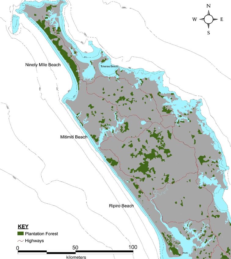
annotated on topographic maps has also shown a larger decrease over time at Ninety Mile than at Dargaville. From the case study on local perspectives, interviews carried out with iwi and others closely associated with toheroa identified six themes that grouped the factors thought to influence toheroa abundance. These themes were the deleterious effects of vehicles on beaches, negative features of the customary permit system, the loss of a stewardship ethic among Maori, adverse effects from land use, effects of cyclical weather patterns, and negative effects from the preferential harvest of large toheroa. Natural processes were considered to have a major influence on toheroa mortality and recruitment, but the cumulative effects of anthropogenic influences were thought likely to severely limit the ability of toheroa populations to recover from large scale natural mortality events or periods of poor recruitment. This review has highlighted a number of factors likely to influence toheroa abundance. To investigate the causal mechanisms operating, a combination of monitoring, experimental, and modelling studies may be necessary. Undertaking zoning work on toheroa beaches by restricting vehicle access to permit comparisons of populations living under the same environmental conditions, but without vehicle stress, may provide detail on how influential vehicle stress is an on toheroa survival. Investigating options for land use change in some areas whilst performing monitoring may provide indications of the relationship between land usage and toheroa abundance. Characterising the environmental conditions on beaches where toheroa populations have not reduced in number as significantly as at others may permit the habitat variables that promote the maintenance of healthy toheroa populations to be elucidated. 1. INTRODUCTION Toheroa (Paphies ventricosa) are a species of large intertidal surf clam endemic to New Zealand. Extensive populations of toheroa were once present in large numbers on exposed surf beaches in the regions of ‘Northland’ (i.e. Northland and Auckland regions), ‘Wellington’ (i.e. Wellington and Manawatu-Wanganui regions), and Southland (Figure 1). Commercial and recreational harvesting of the shellfish was intense during the early to mid 20th century, and populations declined to levels where harvesting was no longer viable. With the exception of limited customary take, harvesting of toheroa has been prohibited for over 40 years in some parts of the country, yet most toheroa populations have failed to recover. The reasons for this are not clear. The aim of this project was to investigate factors that might influence the abundance of toheroa, focusing specifically on sources of mortality and factors affecting recruitment, by collating and reviewing the available information on toheroa. Surveys of toheroa have been carried out at the following six beaches where major toheroa populations were found: Ninety Mile Beach and Dargaville Beach in Northland (Figure 2); Muriwai Beach near Auckland, and the ‘Wellington’ region beaches (Figure 3); and Oreti Beach and Bluecliffs Beach (Figure 4) in Southland. This report presents the existing time series of toheroa abundance estimates generated from those surveys, and reviews the current knowledge available regarding toheroa, including local perspectives gathered from a case study in Northland. Possible factors influencing toheroa abundance were identified, and, where sufficient data were available, these were investigated further. Gaps in our knowledge were outlined and suggestions made for future work to improve our understanding of the processes affecting toheroa. The overall objective of this project was to investigate variations in the abundance of toheroa. The specific objective was to investigate sources of mortality of toheroa and factors affecting the recruitment of toheroa. 2 Factors influencing the abundance of toheroa Ministry for Primary Industries
2. METHODS Data on the abundance and size structure of toheroa for the six main toheroa populations, located at Ninety Mile Beach, Dargaville Beach, Muriwai Beach, the Wellington region beaches, Bluecliffs Beach, and Oreti Beach (Figures 1–4), were collated and entered into a database to create individual time series for the different beaches. Details of the various survey methodologies undertaken and reported are provided in Appendices 1–6. The available published and unpublished literature on toheroa was reviewed, including scientific research papers, Ministry of Fisheries reports, New Zealand Marine Department annual reports, fisheries technical reports, and newspaper and magazine articles. In addition, historical qualitative and anecdotal information on toheroa from Northland beaches was gathered from interviews of local community members that are closely associated with the Northland beaches. This case study is detailed in Appendix 8. Potential pressures on toheroa were identified from the literature review and several of these were investigated further where data allowed. Methods are detailed separately where this has been undertaken. 3. TIME SERIES OF ABUNDANCE Estimates of toheroa population abundance derived from surveys conducted at the six main toheroa beaches are presented in Figures 5–7. Two categories of shell length were used: ‘pre-recruits’ (40–74 mm) and ‘recruits’ (75 mm or larger). On the whole, comprehensive surveys were not conducted until the 1960s at most beaches. Surveys before 1998 did not use sieves as part of the sampling protocol, so estimates of putative ‘juvenile’ toheroa (less than 40 mm) are not presented because they are considered unreliable. 3.1 Northland region beaches Ninety Mile Beach, also known as Te Oneroa a Tohe (‘the long beach of Tohe’), extends from Scott Point to Ahipara Bay (88.5 km, Figure 2) in the Far North district of Northland. This exposed, open coast beach has a low gradient and is backed by extensive sand dunes, which extend up to 10 km inland and reach heights of up to 150 m. Pine forest plantations occupy the majority of the land adjacent to the beach (Brook & Carlin 2000, Walker 2007). Dargaville Beach, also known as Ripiro Beach, is bounded by Maunganui Bluff in the north to Kaipara North Head in the south (72 km, Figure 2) in the Kaipara district of Northland. The beach is long and straight with fine sand, and fresh water seepage between mid and low tide is a common feature of parts of the beach. North of Glinks Gully the beach is backed by sandstone cliffs, while south of Glinks Gully the beach is backed by sand dunes. The littoral width of the beach varies from 180–300 m (Redfearn 1974). A small pine plantation exists at North Head (McKelvey 1999). Muriwai Beach, also known as Te Oneone Rangatira Beach, spreads from the southern side of the Kaipara Harbour entrance to Muriwai village in the south (42 km, Figure 3). It is backed by low sand dunes and pine forests are found behind the entire length of the beach. Technically, Muriwai Beach is in the Auckland region, but for the purposes of this report we have grouped it in the Northland region. The earliest estimates of toheroa abundance for the Northland region were made by several different observers based on observations and limited surveys, and these were summarised by Cassie (1955) and Rapson (1954). The first record was for Ninety Mile Beach in 1920, where there were reportedly 54.5 miles of good toheroa beds, roughly the majority of the beach. A description of part of the stock at Ninety Mile in 1926 suggested that there was an almost inexhaustible supply of toheroa at that time. Mass mortality events were observed in 1930 and 1932, and by 1933 the abundance of large Ministry for Primary Industries Factors influencing the abundance of toheroa 3
toheroa (over 3 inches in length, equivalent to 76 mm) at Ninety Mile was an estimated 11–12 million (which is probably an underestimate because only about 60% of the beach was sampled). In 1938 a heavy and widespread toheroa mortality event was observed along the entire west coast of the North Island, and in 1939 the abundance of large toheroa at Ninety Mile was an estimated 1.4 million, about an order of magnitude lower than in 1933. Following an apparently rapid initial recovery, the toheroa population at Ninety Mile declined in the 1940s to the extent that in 1946 it was ‘considered that the beach had never before been so barren’ and by 1948 toheroa were so scarce that it was difficult to find even a single specimen. By the late 1950s, however, toheroa stocks at Ninety Mile were reportedly improving (O'Halloran 1958, 1959, 1960). At Dargaville Beach, where early estimates of toheroa abundance are very limited, the total abundance of toheroa was reportedly 9 million in 1938 (of which 4.1 million were over 3 inches in length) and about 5 million in 1948. At Muriwai Beach, which has a more complete set of early estimates, the total abundance of toheroa was reported to be fairly consistent between 1937 and 1952, ranging between about 5 and 15 million, except after the heavy mortality event in 1938 when it was less than 1 million. The abundance of large toheroa (over 3 inches in length) at Muriwai was an estimated 6.7 million in 1937 and 5 million in 1942. Estimates of abundance that are available from the more comprehensive surveys that followed from the 1960s onwards show that the populations at Ninety Mile, Dargaville, and Muriwai beaches underwent large fluctuations in abundance in the 1960s and 1970s (Figure 5). For example, two main peaks in abundance are evident at Ninety Mile around 1962 and 1970, each followed by declines over several years. During this period, the estimates of small and large toheroa appear to follow a similar trend. Since around 1980 surveys were conducted only sporadically, but the abundance of large toheroa appears to have remained low, despite occasional high abundances of small toheroa (spat). The most recent surveys at Ninety Mile in 2010 and Dargaville in 2011 were described by Williams et al. (2013). 3.2 Wellington region beaches The ‘Wellington’ region (i.e. Wellington and Manawatu-Wanganui regions) west coast toheroa population surveys were encompassed in the area between Koitiata Stream and Waikanae Beach (74 km, Figure 3). The area was divided into various sections, but the boundaries of the sections were not always consistent between surveys and the entire area was not surveyed in every survey. The structure of all the Wellington toheroa beaches south of Himatangi is similar; the beaches have fine uniform sands with occasional patches of shell and shingle, a gentle gradient, and are backed by sand dunes. North of Himatangi the beaches generally consist of shell grit interspersed with patches of sand. Fresh water seepage between mid and low tide is common on many of the beaches (Tunbridge 1967, Williamson 1969b). Estimates of toheroa abundance for the Wellington region beaches are available for the mid 1960s to mid 1970s period only, except for at Waitarere and Hokio beaches which were also surveyed in 1940 (Figure 6). Toheroa populations were observed to be poor in 1958 and 1959 (O'Halloran 1959, 1960), and stocks were low in 1960, with poor phytoplankton noted that season (O'Halloran 1961). Peaks in abundance followed by declines occurred at all beaches in the mid to late 1960s. 3.3 Southland region beaches Oreti Beach is 29 km long, stretching from the New River entrance to west Riverton. Toheroa surveys usually covered 15.4 km of the beach from 1.8 km south of the south beach entrance to Waimatuku stream (Figure 4). The southernmost 1.8 km of the beach is a designated reserve that is permanently closed to toheroa harvesting (Millar & Olsen 1995). Surveys before 1990 are poorly documented and the methodology is assumed to have remained consistent between years (Beentjes et al. 2003). Bluecliffs Beach is situated in Te Waewae Bay, which stretches from Sandhill Point to Pahia Point (Figure 4). It is a shallow shelving exposed beach backed by sandstone or mudstone cliffs. Toheroa 4 Factors influencing the abundance of toheroa Ministry for Primary Industries
surveys cover the area between Grove Burn and Waikoau River (11.3 km). East of Grove Burn the sediment grades from sand to gravel (Street 1971). Toheroa abundance estimates are available from surveys conducted at Oreti Beach and Bluecliffs Beach since 1969 and 1966, respectively (Figure 7). Abundance estimates, size, and spatial distribution of toheroa at these beaches were reviewed in detail by Beentjes (Beentjes 2010a, b). At Bluecliffs Beach, there has been an overall decline in the abundance of small and large toheroa. The steepest downturn occurred over a ten year period between the mid 1960s and mid 1970s, followed by a more gradual decline since then, albeit with spikes in the abundance estimates in 1997 and 2005. In 2009, abundance at Bluecliffs was very low. Erosion of the beach has meant the area surveyed at Bluecliffs has been reduced since the mid 1980s; the area outside the surveyed area is assumed to be unsuitable for toheroa. At Oreti Beach, the abundance of large toheroa increased in the early 1970s and subsequently fluctuated at a relatively high level until after 1985, when the population almost halved over two years. Abundance decreased further over the next ten years until 1996, when the population reached the lowest level recorded at Oreti. However, estimates since 1998 suggest the Oreti population has markedly increased, with the most recent survey in 2009 indicating abundance is at levels comparable to those observed in the early 1970s and 1980s. 4. REVIEW OF CURRENT KNOWLEDGE 4.1 Overview Toheroa (Paphies ventricosa) are intertidal, suspension-feeding surf clams belonging to the family Mesodesmatidae, which also includes other New Zealand species in the same Paphies genus: pipi (P. australis), tuatua (P. subtriangulata), and deep water tuatua (P. donacina). Toheroa are the largest of these species, growing up to about 150 mm at some beaches. Toheroa inhabit exposed, open coast, fine sand ocean beaches, and are primarily found in the middle of the eulittoral (foreshore) zone, buried up to 20–30 cm below the surface. The bivalve has two long extendable siphons that protrude from the sand when feeding, and a large muscular foot, which enables the shellfish to rapidly burrow into the sand (Morton & Miller 1968). Toheroa are broadcast spawners with separate sexes. Gametogenesis occurs in late autumn and winter, with peak spawning following in early spring (Redfearn 1974). A secondary spawning event may take place in summer, and occasionally a third spawning event may occur in autumn (Redfearn 1974). The larvae are planktonic, spending around three weeks in the water column before settling out of the water column onto the beach, metamorphosing into juvenile toheroa (spat) (Redfearn 1974, 1982, 1997). Growth in the first couple of years is rapid, with toheroa predicted to reach 70–80 mm length in one year and 100 mm in three to five years and estimated to attain a maximum size of 153 mm length and live for up to 20 years (Beentjes & Gilbert 2006b). Toheroa are endemic to New Zealand and were once abundant on Northland west coast beaches (Ninety Mile Beach, Dargaville Beach and Muriwai Beach), Wellington west coast beaches (from Rangitikei River to Waikanae Beach), and Southland beaches (Oreti Beach, and Bluecliffs Beach and Orepuki Beach within Te Waewae Bay) ( Figure 1). Small populations also existed in the North Island at Spirits Bay, Tom Bowling Bay, Tokerau, Te Arai, Mitimiti, Whangape, Pollok, Piha, Ohope, Opotiki, and in the South Island at Hampden Beach, Waikouiti Beach and Long Beach, although only single specimens have been found at the latter two beaches (Hoby 1933, Cassie 1955, Street 1971, Redfearn 1974). Toheroa were a much sought after delicacy by both Maori and New Zealand Europeans. Commercial harvesting of the shellfish began in the late 1800s; harvesting mainly occurred on the Northland Ministry for Primary Industries Factors influencing the abundance of toheroa 5
beaches, and the vast majority of the harvest was canned (Stace 1991). Total commercial production for Northland beaches from 1928 to 1969 was typically around 20 tonne of canned product per annum, with a record production of 77 tonnes in 1940 (Redfearn 1974). Toheroa were also canned at the Wellington beaches and in Te Waewae Bay at various times, for very short durations (Redfearn 1974). By 1969 toheroa populations around the country had declined to such an extent that commercial harvesting was no longer economically viable, and all commercial harvesting ceased in 1969 (Redfearn 1974). Recreational harvesting pressure on toheroa populations was intense from the early 1900s onwards, though little quantitative data is available. Harvesting regulations were introduced in 1932 and became progressively more restrictive, in an attempt to control the nationwide population decline in toheroa stocks. However, toheroa populations continued to decline and recreational toheroa harvesting has been prohibited from Ninety Mile Beach since 1971, from Muriwai since 1976, from the Wellington beaches since 1978, from Dargaville and Te Waewae Bay since 1980, and from Oreti Beach since 1993. Adult populations have still not recovered to a level that would allow commercial or recreational harvesting, and no toheroa harvesting is currently permitted within New Zealand, with the exception of limited customary harvests (Greenway 1972, Redfearn 1974, McKinnon & Olsen 1994, Akroyd 2002, Beentjes & Gilbert 2006a). Given that large toheroa were once abundant on several exposed New Zealand beaches, it appears that certain aspects of the population dynamics or supporting habitat have changed, so that these areas can no longer support large adult toheroa populations. Over the last 40 years, toheroa populations appear to have received erratic (and occasionally quite substantial) recruitment pulses, followed by large scale mortality that prevents increases in adult abundance (Morrison & Parkinson 2001, 2008). The specific processes that influence recruitment and mortality of toheroa have been speculated upon, but have not been methodically studied. By reviewing the factors that might influence the recruitment and mortality of toheroa, using the available scientific, customary, and historical information, we aim to provide a better understanding of the processes that might be driving the decline of this iconic New Zealand shellfish. 4.2 Recruitment process Recruitment, in an ecological sense, is defined as the addition of new individuals to the population. In the context of this report, recruitment is defined as the successful settlement of juvenile toheroa (spat) on the beach. 4.2.1 Reproduction Toheroa are gonochoristic (the sexes are separate in different individuals, and sex does not change over an individual’s lifetime), with a 1:1 male to female sex ratio, though very occasionally hermaphrodite individuals are found (Hoby 1933, Smith 2003). It has been estimated that the majority of toheroa reach sexual maturity at 32 mm in length, at an age of 9 to 15 months (Redfearn 1974), though recent growth estimates of South Island toheroa suggest that toheroa could reach sexual maturity in well under one year (Beentjes & Gilbert 2006b). In a study by Redfearn (1974), all toheroa were found to be mature by 47 mm in length. Toheroa reproduce by broadcast-spawning, releasing their gametes into the seawater for external fertilisation. They have a semi-continuous reproductive strategy, with spawning and subsequent recovery through the maturation of gametes potentially occurring several times from late winter to early autumn. In northern populations, gametogenesis occurs over late autumn and winter, with toheroa reaching maximum reproductive condition in late winter (July–September). A major spawning peak occurs in late winter–spring (July–November), with up to 80% of the population spawning. Histological studies show that gonads may rapidly redevelop within one month of 6 Factors influencing the abundance of toheroa Ministry for Primary Industries
spawning, and a second spawning event often occurs in summer (December–January). In some years toheroa may spawn a third time in autumn (March), and partial (‘trickle’) spawning can occur at any time during the year (Redfearn 1974, 1982, 1997, Smith 2003). No reproductive studies have been conducted on southern toheroa populations. Like many other temperate bivalves, it is thought that environmental conditions, such as an abundance of food and changes in water temperature, primarily determine the onset and duration of spawning in toheroa (e.g., Muranaka & Lannan 1984, Devauchelle & Mingant 1991, Utting & Millican 1997). Toheroa have been observed spawning in situ on Dargaville Beach. In one instance, spawning occurred for a period of 10 minutes at night on an incoming tide where 80–100 adults emerged from the sand with their siphons extended. Gametes were released in a stream from their exhalent siphon on the incoming waves (Akroyd 2002, Smith 2003). Mature eggs are 60–90 μm in diameter and adult females can release 15 to 20 million eggs during a single spawning period of 2–3 hours (Hoby 1933, Redfearn 1982). Fecundity of female toheroa increases with length, though the exact size-fecundity relationship is unknown. Hoby (1933) estimated that a 56 mm (shell length) toheroa contained about 2 million eggs, whereas a 106 mm toheroa contained between 11 and 23 million eggs. Oocyte diameter was found to vary significantly within an individual, and toheroa only release a portion of their gametes during a spawning event (Smith 2003). Small to medium toheroa (less than 80 mm shell length) had a larger variation in oocyte diameter and condition index during the spawning season compared to large toheroa (greater than 80 mm). This suggests that smaller toheroa release the majority of their eggs during a spawning event providing a short pulse of gametes, whereas large toheroa spawn more frequently but release a smaller percentage of their eggs at any one time, providing a more sustained supply of gametes (Redfearn 1974, Smith 2003). Smith (2003) found a high level of gametogenic synchrony between male and female toheroa. Such reproductive synchrony is often observed in broadcast spawning marine invertebrates, and is widely thought to be an adaptation to maximise fertilisation success. For toheroa in particular, specific cues may be important to synchronise spawning, otherwise the chance of fertilisation occurring in such a turbulent environment is likely to be very small. Kaitiaki (a Maori word meaning ‘guardian with an obligation’) of Dargaville Beach believe that toheroa spawn around the time of the full moon (Smith 2003), and Akroyd (2002) reported several observations of toheroa spawning during the days leading up to the full moon. Smith (2003) studied the relationship between toheroa spawning and the lunar cycle, and suggested that spawning events may be correlated to a semi-lunar rhythm, with spawning occurring around the time of either a new moon or a full moon. However, a more frequent and regular sampling regime conducted over the entire year is required to confirm this. 4.2.2 Fertilisation and larval development Toheroa larvae have been reared to settlement stage under hatchery conditions (Redfearn 1982). Mature adults collected from the field were induced to spawn by scrubbing them with a brush and then subjecting them to temperature fluctuations between 20 and 28°C, as well as adding a sperm suspension to the water. Eggs and sperm were collected separately and artificially fertilised. Toheroa sperm rapidly cluster around the unfertilised eggs and fertilisation occurs within 30 minutes. Sperm remain active for up to seven hours if no eggs are present (Hoby 1933). Fertilised eggs produce two small polar bodies shortly after fertilisation has occurred, and within 2–4 hours the eggs show the first and second cleavages (Smith 2003). Ciliated blastulae appear 15–24 hours after fertilisation, and straight-hinge veligers develop 24–48 hours after fertilisation (Smith 2003). The veligers progress to umbo stage larvae at lengths of 109–140 μm, and pediveliger larvae were observed at lengths greater than 250 μm (Smith 2003). The majority of larvae settled at 270–300 μm in length, after approximately 22 days culture at 25°C (Smith 2003). The timing of settlement varied considerably, and it is likely that toheroa larvae, like many other bivalves, have the ability to Ministry for Primary Industries Factors influencing the abundance of toheroa 7
delay settlement if a suitable settlement substrate cannot be found (Hoby 1933, Redfearn 1982, Smith 2003). 4.2.3 Settlement In ecology, settlement is defined as the transition from a pelagic to a benthic life phase. The process begins with the onset of a behavioural search for a suitable settlement substratum and ends with metamorphosis of the individual. Certain bivalves also exhibit secondary settlement behaviour, where young spat may detach and re-settle a number of times by producing a long mucus thread that increases the viscous drag on the animal, allowing it to drift in the currents. Known as bysso-pelagic drifting, the occurrence of this behaviour has not been investigated for toheroa, but has been found to occur in certain closely-related Mactrid clams (Sigurdsson 1976). Toheroa spat are washed ashore and the majority settle on the beach just below the high water mark. Peak settlement of spat (2 mm or more shell length) occurs in summer (December–January), one to two months after the peak spawning period (Redfearn 1974). In years when settlement is high, spat can be found as a continuous band along the beach. It is thought that this distribution is caused by the surf dislodging small toheroa and depositing them near the high water mark. Initially, spat have a limited ability to burrow, and instead anchor themselves to the substrate by attaching a byssus thread to sand grains. At a length of 2 mm spat can burrow to a depth of 1–2 cm below the surface. As the shellfish grow they progressively move lower down the shore to around the mid-tide level, and burrow to greater depths (Redfearn 1974, 1982, McKinnon & Olsen 1994, Redfearn 1997, Beentjes & Gilbert 2006a). It is not known whether toheroa have any particular physical, chemical, or biological cues for settlement. Beaches that contain toheroa share a number of common features including open exposed surf conditions, a wide shallow gradient (dissipative beach), usually backed by sand dunes or cliffs, fine uniform sand with an average grain size of 0.21–0.33 mm, high levels of fresh water seepage on the beach, and high concentrations of phytoplankon (Rapson 1952). Anecdotal reports state that toheroa are more common in areas where freshwater runs down the beach or where the water table lies close to the surface. When the tide is out, the sand in these areas remains moist for longer periods of time, and toheroa living there may have a lower risk of desiccation. Toheroa at Dargaville Beach were found to be living just above the water table, which was 100–300 mm below the surface (Akroyd 2002). In some areas, toheroa have also been associated within small embayments along the beach, where eddy currents may concentrate phytoplankton and toheroa larvae (Rapson 1952, Cassie 1955, Redfearn 1974, Akroyd et al. 2002, Smith 2003, Akroyd et al. 2008). Toheroa spat are seldom found in adult beds, and occasionally separate juvenile beds are found (Cassie 1955), indicating that spat do not settle directly in the adult beds. Smith (2003) found that densities of juvenile toheroa (less than 32 mm) on the upper shore were significantly higher in areas directly above adult beds, compared to areas where no adult beds were present. This putative juvenile- adult association could be the result of: 1) larval attraction to adult toheroa (e.g., by chemical cues); 2) onshore water currents that regularly deposit planktonic larvae at the same locations along the beach; or 3) favourable environmental conditions that lead to higher survival rates in certain locations. In contrast, juveniles on Oreti Beach are spread along the entire length of the beach and do not appear to be clearly associated with any of the main beds (Beentjes & Gilbert 2006a). 4.3 Post-settlement feeding, growth, and movement 4.3.1 Feeding The surf zone of exposed sandy beaches is a highly productive environment, capable of supporting a large infaunal biomass. The strong wave action on surf beaches pumps sea water through the sand, releasing trapped algae, organic detritus, and inorganic nutrients into the water column. These 8 Factors influencing the abundance of toheroa Ministry for Primary Industries
regenerated nutrients are capable of supporting a high production of diatoms, which in turn support numerous filter-feeding organisms, including toheroa, which live in the surf zone (McLachlan & Brown 2006). Cassie (1955) observed that dense phytoplankton blooms were a common occurrence on all beaches where toheroa are present, and he hypothesised that toheroa relied on these blooms to obtain sufficient nutrients. The occurrence of phytoplankton blooms on toheroa beaches is dependent on the availability of nutrients (both from the interstitial water and beach run-off), the occurrence of onshore winds to drive the phytoplankton onto the beach, and favourable environmental conditions. Anecdotal reports suggest that toheroa condition markedly improves after the autumn rains commence, coincident with the dense phytoplankton blooms, visible as a ‘greenish-brown scum on the beach and in the water’ (Hefford 1931). Toheroa are generalist filter feeders, consuming phytoplankton and organic debris up to 25 μm in size. Diatoms of the genus Chaetoceros are some of the most predominant phytoplankton in exposed inshore coastal waters (Rapson 1954, Street 1971), with Chaetoceros armatum accounting for up to 96% of the phytoplankton in the water at Dargaville Beach during May (Rapson 1954). The same study indicated that the plankton cycle on the west coast of the North Island was influenced by westerly winds blowing for most of the year which permit the inshore phytoplankton flora to build up; zooplankton did not generally thrive until easterly winds occurred, around October, allowing zooplankton to dominate inshore. On a fairly regular basis, tropical and subtropical genera were added to the plankton from the north. The average quantity of phytoplankton at each of four west coast beaches (Ninety Mile, North Kaipara, Muriwai and Wellington) was calculated as ranging from 1.4 (Ninety Mile Beach) to 59.9 g per cubic metre dry weight (North Kaipara). Toheroa have a slightly different feeding mechanism from the closely related tuatua. Both shellfish are filter feeders, but toheroa ingest both organic and inorganic material, which is sorted in the alimentary canal, whereas tuatua have an efficient sorting mechanism that operates before ingestion. Cassie (1955) proposed that the difference in feeding mechanism between the two species gives tuatua a greater ability to survive in low food conditions. When phytoplankton concentrations are low, the diet of toheroa includes a greater proportion of inorganic material than that of the tuatua, the latter being able to sort and discard inorganic material before ingestion. 4.3.2 Growth Growth rates of toheroa have been estimated by combining length-frequency cohort analysis with the measurement of macroscopic shell rings. Assuming these shell rings are laid down annually, North Island toheroa have been estimated to reach 43 mm after one year, 71 mm after two years, and 100 mm after 4–5 years (Redfearn 1974). Cassie (1955) reported that South Island toheroa from Oreti Beach had a much slower growth rate, with toheroa reaching 32 mm after one year, 44 mm after two years, and 100 mm after 9 years. It should be noted, however, that shell rings of toheroa may not be laid down on an annual basis and that shell reading of toheroa remains to be validated before growth and longevity could be confidently estimated (Naylor et al. 2010). Beentjes & Gilbert (2006b, a) more accurately predicted the growth rates of South Island toheroa from mark and recapture data (41 out of 600 marked toheroa were recaptured at Te Waewae Bay after a release period of up to 26 months, and 98 out of 930 marked toheroa were recaptured at Oreti Beach after up to 4 years). Predicted growth rates were much faster than those of Cassie (1955) and Redfearn (1974), with toheroa at Te Waewae Bay predicted to reach 80 mm in one year and 100 mm in three years. The predicted growth rate for toheroa at Oreti Beach was slightly slower, with toheroa predicted to reach 70 mm in the first year and 100 mm in four to five years. Growth slows substantially in larger animals, with adults reaching a maximum size of about 150 mm and a maximum age of 20 years (Cassie 1955, Brunton 1978, McLachlan et al. 1996, Beentjes & Gilbert 2006b, a). The maximum size of toheroa differs between populations, with toheroa from Te Waewae Bay attaining the greatest recorded maximum size of 153 mm. Based on an examination of historical Ministry for Primary Industries Factors influencing the abundance of toheroa 9
survey data, the maximum size of toheroa recorded from Wellington and Oreti Beaches is about 145 and 136 mm respectively (Beentjes & Gilbert 2006a), and Northland toheroa appear to grow to a maximum size of about 130 mm. No growth estimates based on mark and recapture data are available for northern toheroa populations, and it is unknown whether: 1) the growth rate of northern populations varies from that of southern populations, 2) growth rates vary between years, and/or 3) the difference in growth rate estimates is caused by the different methodologies used. Beentjes & Gilbert (2006b) suggested that the lower maximum size and lack of large toheroa (over 100 mm) in current Northland populations may be because of a slower growth rate and/or higher mortality rate in Northland populations. 4.3.3 Movement Movement of toheroa may be active or passive. Tagging experiments have shown that while the majority of animals are sedentary, some tagged individuals actively move several miles from their release point (Greenway & Allen 1962). Vertical distribution of toheroa on the shore varies with size of the shellfish. Newly settled spat are most abundant just below the high tide mark, juvenile toheroa (under 40 mm) are most numerous on the upper shore, though they occupy a wide vertical range of the intertidal zone, and adult toheroa are generally concentrated in a narrow band around mid-tide level (Cassie 1955, Beentjes et al. 2003, Williams et al. 2013). This segregation by size suggests that active movement is occurring as toheroa grow in size. Toheroa use the swash of waves to actively move up and down the beach, with movement mainly occurring at night. The shellfish emerge out of the sand with their siphons extended just before a wave break. As the swash wave passes over the shellfish they release their foot and are carried away in the direction of the flow. Once the wave recedes the toheroa rapidly burrow back into the sediment, completely burying themselves within one minute (Mestayer 1921, Cassie 1955, Smith 2003). Thousands of toheroa have been observed to emerge at one time and entire beds are reported to move both along the beach, and up and down the shore, with beds moving 30 m or more during a night (Redfearn 1974, Akroyd 2002). The factors that trigger a mass migration of toheroa are not known, but local kaitiaki report that on a number of occasions entire toheroa beds have shifted location after a storm (Akroyd 2002). Passive movement of juvenile toheroa can be caused by strong winds and waves which have been observed to expose juvenile toheroa, which can be found drifting in the swash zone (Street 1971, Moller et al. 2009). Similarly, strong winds may cause the aggregation of toheroa spat. For example, after a prolonged period of southwesterly gales a very high concentration (over 1200 per 0.5 m2 quadrat) of juvenile toheroa (under 26 mm) was found in a small isolated patch in the northeast corner of a small bay on Dargaville Beach (Akroyd et al. 2008). 4.4 Sources of post-settlement mortality Post-settlement mortality of toheroa is likely to be caused by numerous factors, both natural and anthropogenic. The elements that may affect post-settlement mortality can be divided into physical, biological and chemical factors. Mass mortalities of toheroa populations appear to be a relatively common occurrence and usually occur during summer in northern populations, but are more frequent during winter in southern populations. The most likely sources of post-settlement mortality in toheroa are discussed below. 4.4.1 Physical factors Physical factors are considered here to be those causing physical damage to toheroa or their habitat. 10 Factors influencing the abundance of toheroa Ministry for Primary Industries
4.4.1.1 Desiccation Several summer mass mortality events in northern toheroa populations were observed to have been preceded by calm weather conditions, easterly (offshore) winds, and neap tides, which resulted in the tides not covering toheroa beds for several days. Mass mortalities in northern populations have been reported in the summers of 1932, 1938, 1956–1959, 1970, 1973, and 2001 (Cassie 1951, Redfearn 1974, Akroyd et al. 2002). The causal mechanism for the mass mortality events is, however, unknown. It is possible that certain weather conditions cause toheroa stress, perhaps by changing the temperature or availability of water within their local habitat. It has been suggested that toheroa living in areas of fresh water seepage may have greater protection from desiccation, and they are anecdotally reported to be more common in these areas (Rapson 1952, 1954, Greenway 1972, Stace 1991, Redfearn 1997) and may be more susceptible to desiccation than the closely related tuatua, which occupy a position lower on the shore. Furthermore, adult toheroa cannot completely close their shells, instead, the gaps between the valves are covered by folds of the mantle (Redfearn 1974, 1997). 4.4.1.2 Storms Southland toheroa populations appear to be susceptible to cold, stormy weather. Toheroa burrowing speed is reduced at cold temperatures (G. Bremner & A. Frazer, MFish, pers. comm. in Carbines 1997a), making toheroa more vulnerable to exposure by storm conditions. Millions of dead and moribund toheroa have been stranded on Southland beaches after heavy southerly seas in the winters of 1967, 1968, 1970, and 1988 (Street 1971, Eggleston & Hickman 1972, Street 1972, Langston 1990). Toheroa are not the only shellfish affected by winter storms; in September 1970 more than 20 million shellfish, including approximately 5000 toheroa, were stranded at Te Waewae Bay after a period of very cold, gale-force inshore winds (Eggleston & Hickman 1972). 4.4.1.3 Sand smothering and sediment instability The sand on surf beaches is highly mobile and strong wind and wave conditions are capable of shifting large quantities of sand in a short period of time. During storms, benthic macrofauna living in the intertidal zone are at risk of either being smothered, or exposed and washed ashore, where they are more vulnerable to desiccation or predation. Westerly wind and wave conditions prevail on the west coast of New Zealand, which generally facilitate the accrual of sand on the beach. However, easterly winds frequently occur during spring, which blow considerable quantities of sand down from the dunes onto the beach. Juvenile toheroa living near the high water mark are deeply buried during easterly gales and are likely to be smothered to death (Rapson 1952). For example, in April–May 1930 strong easterly gales deposited large quantities of sand (less than 60 cm deep) on the toheroa beds on Ninety Mile Beach. Approximately 15 million shellfish were killed in a section of the beach 40–56 km north of Ahipara (Hefford 1931, Rapson 1954). Sediment instability is thought to have contributed to the decline of the toheroa population at Bluecliffs Beach, Te Waewae Bay. Aerial photographs taken of the beach in 1947 show that it had a continuous sand coverage, and during the 1960s there was a considerable depth of sand covering the gravel/cobble basement sediment. However, the sand layer has been gradually eroding away and by 2005 exposed cobble and gravel covered much of the beach, with only 54% of the beach surface being sand. Furthermore, up to 50% of the sand patches had an underlying gravel layer within 30 cm of the surface, which is likely to impede toheroa burrowing. This reduction in suitable habitat for toheroa is thought to have contributed to the population decline at Bluecliffs Beach, which has been steadily declining since population surveys began in 1966 (Beentjes et al. 2006). Sand levels at Bluecliffs Beach are recorded to fluctuate between winter and summer surveys, by up to 40 cm over a three month period. During winter, storms scour the beach and very little sand substrate is available, while during summer sand accrues on the beach. The location of sand patches Ministry for Primary Industries Factors influencing the abundance of toheroa 11
on the beach is also documented to shift, forcing any toheroa within to relocate (Beentjes & Gilbert 2006b). Frequent movement of toheroa will increase their mortality risk, as toheroa moving in the surf zone are more susceptible to being preyed upon or stranded high on the shore. 4.4.1.4 Vehicle impacts Several research studies have shown that vehicle beach traffic has adverse effects on beach flora and fauna including direct crushing of animals and vegetation (Buick & Paton 1989, Van der Merwe & Van der Merwe 1991, Schlacher et al. 2008), disturbance of seabird breeding and feeding behaviour (Buick & Paton 1989), increased erosion of the sand dunes, and changes to the physical characteristics of the beach and dunes (Anders & Leatherman 1987). Most of New Zealand’s toheroa beaches are used by vehicles for recreational purposes, however limited quantitative data are only available for Ninety Mile Beach, Muriwai Beach, and Oreti Beach. Ninety Mile Beach is a designated state highway and is subjected to high vehicle traffic. Currently, around eight commercial tour operators drive along Ninety Mile Beach (S. Harding, DOC, pers. comm.) using vehicles that weigh up to 13 tonnes, and about 2400 commercial bus trips are made along Ninety Mile Beach annually (enquires were made with all commercial Ninety Mile Beach tour operators registered with the Department of Conservation on their trip statistics; seven out of ten operators provided confidential information on their annual trip total). In 1991, Stace (1991) reported that up to 35 tourist buses per day were driving along the beach in summer. No information is available on the number of private vehicle trips made along Ninety Mile each year, but nearly 400 vehicles were counted travelling along the beach during one day of a recreational fishing contest (the ‘Snapper Classic’ surfcasting fishing competition, an annual five day event held at Ninety Mile Beach that attracts up to 1000 entrants; see http://www.snapperclassic.co.nz/index.html) (Hooker & Redfearn 1998). The beach is also used by commercial mussel spat harvesters, who drive tractors and trailers along the lower half of the beach. Similarly, Oreti Beach is a designated road and approximately 374 vehicles drive along the beach per day in summer, though the majority of vehicles stay within 1 km of the main beach entrance at Dunns Rd (Wilson 1999). Oreti Beach is the location of the annual Burt Munro motorbike challenge, which draws approximately 1700 vehicles to the beach for the event. The actual race track covers about a one kilometre stretch of the beach (Moller et al. 2009). Muriwai Beach is a popular recreational beach and approximately 150 vehicles per day visited the beach between December 2008 and April 2009 (Auckland Regional Council, unpublished data). There is good evidence that toheroa mortality can be caused by beach vehicle traffic (Redfearn 1974, Brunton 1978, Hooker & Redfearn 1998, Moller et al. 2009). Toheroa may be affected by vehicle pressure in a number of ways including direct crushing, increased desiccation risk, or increased predation risk from birds. Disturbance of buried toheroa by vehicles will cause the toheroa to retract its foot and siphons, leaving it temporarily unanchored below the surface. The compression of the sand by the weight of vehicles also causes the water trapped between the sand to puddle, and the unanchored toheroa will tend to be pulled upwards towards the surface. Repeated compressions by vehicles will cause the animal to emerge out of the sand, forming a distinctive hummock as it emerges, where it may be crushed by other vehicles or preyed upon by birds (Brunton 1978, Hooker & Redfearn 1998). Moller et al. (2009) conducted an experimental study to investigate the impact of vehicle traffic on toheroa. Preliminary tests on ten buried adult toheroa found that none were damaged by vehicle passes, and therefore, the study focused on juvenile toheroa (5–30 mm). Three hundred and three juvenile toheroa found drifting in the surf zone were allowed to bury themselves either just below the high tide mark or in the mid/lower beach. The toheroa were then driven over one or five times with a motorbike (Honda CRD 250R), car (Toyota Fielder), or utility vehicle (Mazda BT50 Freestyle cab and Isuzu Bighorn). Toheroa mortality was found to vary with location on the beach and type of vehicle. For all vehicles excluding motorbikes, the average mortality incurred was higher on the upper beach (14%) compared to the mid/lower beach (3%); for motorbikes, the average mortality incurred 12 Factors influencing the abundance of toheroa Ministry for Primary Industries
was high (18%) compared with that from the other vehicles (3%, average mortality across all other vehicles). Driving the test vehicle five times over the toheroa appeared to cause higher mortality than a single pass, but the difference was not statistically significant. The occurrence of beach events such as fishing contests and off-road vehicle races has the potential to cause significant toheroa mortality. Hooker & Redfearn (1998) found that 14% of (26 out of 160) juvenile toheroa (6–23 mm) in three 1 m2 quadrats were crushed after particularly heavy vehicle use of Ninety Mile Beach during a large recreational fishing contest. Similarly, Moller et al. (2009) found that an estimated 53 000 (range 31 000–70 000 individuals or 41–90%) juvenile toheroa (72%) were killed on about a one kilometre stretch of Oreti Beach used for the Burt Munro motorbike race. Toheroa mortality along the rest of the beach caused by spectator traffic was not measured. Thus, it appears that low levels of vehicle traffic on the beach do not cause significant mortality of adult toheroa, but even a single pass can cause significant mortalities in juvenile toheroa, particularly those which live high on the beach in soft sand. High levels of toheroa mortality can be caused by beach events, but mortality is often likely to be localised, and it is unknown what proportion of the overall mortality rate of toheroa is caused by these events. 4.4.1.5 Land devegetation and afforestation In Northland, the surrounding land of Ninety Mile beach on the Aupouri Peninsula and Dargaville and Muriwai beaches on the Kaipara coast was originally covered in native broadleaf forest (Smale et al. 1996). Initial Polynesian settlers cleared much of the forest with fire approximately 500–700 years ago (Coster 1989), and early European settlers and their livestock destroyed much of the remaining vegetated areas (Bacon 1976, McKelvey 1999). As a consequence of the removal of coastal vegetation, sand drifting became a large problem on the Aupouri Peninsula and Kaipara coastline in the 1920s, and large areas of coastal farmland and lakes were covered by sand. To stabilise the sand dunes, a large-scale planting programme of marram grass and tree lupin was instigated in the early 1930s by the Ministry of Works. In the early 1950s the government announced that a number of coastal areas around the country were to be converted to state forestry (exotic pine forest, Pinus radiata), including most of the area behind Ninety Mile Beach (Aupouri State Forest), Muriwai Beach (Woodhill Forest), and North Kaipara Head (Pouto Forest) in Northland, and Waitarere Beach (Waitarere Forest), and Tangimoana Beach (Tangimoana Forest) on the Kapiti Coast. Planting of Woodhill Forest and Kapiti Coast forests commenced in the early 1950s, planting of Aupouri State Forest commenced in the early 1960s, and planting of Pouto Forest commenced in the early 1970s (McKelvey 1999). Conversion of the sand dunes to pine forest began with the planting of marram grass to stabilise the dunes. The marram grass was aerially top-dressed with nitrogen fertiliser (at a rate of 20 kg fertiliser/ha) twice a year in spring and autumn. Tree lupins were sown amongst the marram grass a couple of years after the marram grass had been planted, to add nitrogen to the soil and to provide additional shelter. Eventually pine trees were planted four to six years after marram grass was planted. Once the pine trees had become established it was necessary to kill the lupins to prevent them from smothering the pine trees. Initially, the lupins were cut down by hand or mechanically, but during the 1970s they were aerially sprayed with hormones (Tordon or 2,4,5-T Ester) to kill them (Bacon 1976, Sale 1985, McKelvey 1999). In the late 1980s, fertilisation of the pine forests with urea at a rate of approximately 450 kg/ha was required to compensate for the loss of nitrogen that the lupins provided. As an alternative to urea fertilisation, Waitarere Forest was fertilised with sewage effluent from the local township. Fertilisation of the coastal dune vegetation with urea also occurred at a rate of 100 kg/ha every two years in spring to promote growth of coastal vegetation, which protected the forests (Ogle 1997, McKelvey 1999). Ministry for Primary Industries Factors influencing the abundance of toheroa 13
You can also read