Agriculture in Iraq: Resources, Potentials, Constraints, and Research
←
→
Page content transcription
If your browser does not render page correctly, please read the page content below
Agriculture in Iraq:
Resources, Potentials, Constraints, and Research
             Needs and Priorities

                      A. A. Jaradat
              NCSC Research Lab, ARS-USDA
                    803 Iowa Avenue,
                   Morris, MN 56267

                       Submitted to:
                    Department of State –
          Middle East Working Group on Agriculture
                      October 5-6, 2002
                   Washington, D. C., USA

                             1
2
Executive Summary ……………………………………………………………5

1. Introduction   ……………………………………………………………8

2. Regional Patterns: …………………………………………………………..10
       2.1. Climate …………………………………………………………..10
       2.2. Physiography …..…………………………………………………..14
       2.3. Population ………………………………………………………….21

3. Land and Water Resources …………………………………………………..24
       3.1. Land resources ……………………………………………………..24
       3.2. Land Use …………………………………………………………..24
       3.3. Land Degradation ………………………………………………….25
       3.4. River Basins ………………………………………………………. 26
       3.5. Surface Water Resources …………………………………………..26
       3.6. Ground Water Resources …………………………………………..28
       3.7. Dams ……………………………………………………………….28
       3.8. New Watercources …………………………………………………28
       3.9. Water Withdrawal ………………………………………………….29
       3.10. Irrigation and Drainage …………………………………………...29
       3.11. Irrigated Areas ……………………………………………………29
       3.12. Salinity ……………………………………………………………30
       3.13. Trends in Water Resources Management ………………………...32

4. Soils of Iraq ………………………………………………………………….35

5. The Agrarian Structure ………………………………………………………37
       5.1. Institutional Environment ………………………………………….37
       5.2. Land reform ………………………………………………………..37

6. Biodiversity and Plant Genetic Resources …………………………………..40
       6.1. Biodiversity ………………………………………………………..40
       6.2. Plant Genetic resources ……………………………………………41

7. Crops ………………………………………………………………………...44
       7.1 Small Grains ………………………………………………………..45
       7.2 .Food Legumes ……………………………………………………..47
       7.3. Industrial Crops ……………………………………………………48
       7.4. Vegetables …………………………………………………………48
       7.5. Fruit Trees …………………………………………………………49
       7.6. Date Palm ………………………………………………………….50
       7.7. Medicinal Plants …………………………………………………...52

                                  3
7.8. Crop Protection ……………………………………………………53
       7.9. Seed Industry ………………………………………………………54

8. Forest Resources …………………………………………………………….56
       8.1. Natural Forests …………………………………………………….56
       8.2. Afforestation and Reforestation …………………………….……..57
       8.3. Fuelwood and Wood Products Needs ……………………….…….58

9. Rangelands …………………………………………………………….…….60
       9.1. Rangeland Management and Rehabilitation ……………….……...60
       9.2. Rangelands Problems ……………………………………….……..61
       9.3. Alternative Feed Sources …………………………….……………63

10. Livestock ………………………………………………………….………..65
       10.1. Livestock Production and Management ……………….…………65
       10.2. Animal Health ……………………………………………………66

11. Fisheries and Aquaculture ………………………………………………….68

12. Apiculture …………………………………………………………………..70

13. The National Agricultural Research System (NARS) of Iraq ……………...71
       13.1. Historical background …………………………………………….71
       13.2. The current NARS ………………………………………………..72
       13.3. Research Policy …………………………………………………..74
       13.4. Human Resources ………………………………………………...76
       13.5. Financial and Physical Resources ………………………………..76
       13.6. National and International Linkages ……………………………..77

14. Research Needs and Priorities ……………………………………………..78
       14.1. Restructuring the National Agricultural Research System ………78
       14.2. Capacity Building ………………………………………………..78
       14.3. Strengthening the Role of Iraqi Universities in Ag. Research …..79
       14.4. Research Needs and Priorities in the Rainfed, Irrigated and
             Rangeland Production Systems of Iraq. …………………………81
15. Selected References. ……………………………………………………....83

                                           4
Executive Summary

Since the early 1980s, it has been extremely difficult to obtain
                                                                          During the last 2
accurate statistics and reliable information on agricultural activities   decades, Iraqi
within Iraq. During the last two decades, agricultural systems in         agriculture faced
the dry-, irrigated- and range- lands of that country faced an            increasing
unprecedented pressure to meet the food requirements of a                 pressure to feed a
population increasing at about 3% annually. The current situation         population of 22.8
                                                                          m, increasing at a
is creating new, more intensive, and more diverse demands on              3.6% rate
farmers, agricultural producers and planners. Although the                annually.
agricultural sector, during the last decade, has been given high
priority to ensure food security through greater self- sufficiency, the
country, and for the foreseeable future, will continue to depend on
imported food.

The agrarian sector in Iraq witnessed a number of drastic measures
during the last 40 years. These include: land reform, cooperative
and collective state farming, central planning and, finally, private
ownership. Estimates of cultivable land areas vary from 5-8
million ha; however, no more than 3.5 million ha (47% irrigated
and 53% dryland farming) have been actually cultivated.

Rural to urban migration within the country is widespread, and
threatens the social and economic stability. The demographic              Iraq has ~ 11.0 m
pressure on the land combined with the need to produce more food          ha of arable land;
                                                                          3.5 m ha are
from a limited, and shrinking, resource base of land and water are        cultivated.
forcing farmers to follow exploitative production practices that
maximize short-term returns at the expense of long-term                   Decreasing water
sustainability.                                                           resources may
                                                                          force a structural
                                                                          adjustment of the
Renewable fresh water resources are estimated at about 2,000              agricultural
m3 /person/year; however, Iraq faces huge water problems; these           sector.
are caused by geographic, topographic and management factors.
Major structural adjustments in the agricultural sector are needed
to solve water management problems in the country.

Growing water shortages, especially from the Euphrates, were
characteristic of the 1990s. With continued population growth,
irrigated agriculture has to compete with the municipal and
industrial sectors for water. The combined Iraqi water demand on
the Tigris and Euphrates in the period after 2020 would range from
70,000 to 90,000 MCM. This could result in a negative balance of
15,000 MCM, mainly on the Euphrates. Just how severely this

                                              5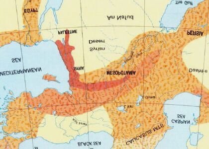
water shortage will impact Iraq’s agriculture is impossible to
estimate at the present time.

Prior to 1990, Iraq produced about one-third of its annual basic
food needs and spent about US$ 2 billion to import the balance of
its requirements. Since then, despite emphasis on increasing food
production, and despite the Oil- for-Food Program, undertaken
under the auspices of the United Nations since1996, the country
continues to face deterioration in the agricultural sector.

Agricultural production remains constrained due to lack of quality
seed, herbicides, insecticides, fertilizers, animal vaccines,
machinery, irrigation equipment and spare parts. Moreover, water
resources in the drylands are declining (estimated at 43% of
normal levels in 1998) due to a severe drought which devastated
crops on ~70% of the rainfed arable land in the country. It is
estimated that Iraq will need US$ 3.5 billion to import basic foods
to meet the annual shortages during the next decade.

Farmers in Iraq are struggling to produce under poor
environmental conditions with few tools for coping with drought,       Iraqi farmers
salinity, pests, and shortages of inputs and lack of appropriate       have to cope
                                                                       with drought,
technologies. Iraqi cereal production dropped sharply in the past      salinity, pests,
decade due to problems with its seed multiplication system,            lack of inputs
leading to degradation of seed quality and productivity. Planting      and lack of
low-quality seeds during the 1980s and 1990s led to problems of        appropriate
weed infestation and pest attacks, low productivity and an inability   technologies.
to use seed-processing machinery efficiently. Lack of high-
yielding seed has reduced farm efficiency and often forced poor
farmers to abandon their lands.

Land degradation, salinization, and declining crop yields due to
mismanagement of land resources and lack of inputs, are serious
problem, especially in the irrigated lands. The country’s rangelands
and forest resources are deteriorating mainly as a result of
overstocking what are essentially fragile ecosystems and because
of deforestation for fuelwood and charcoal.

The livestock sector experienced serious problems during the last
decade because of shortages of feed, veterinary services and
vaccines. Number of farm animals declined during the last decade,
and in spite of the government’s efforts to boost livestock
production, meat and milk production declined by 24% during the
late 1980s as compared to the 1970s.

                                            6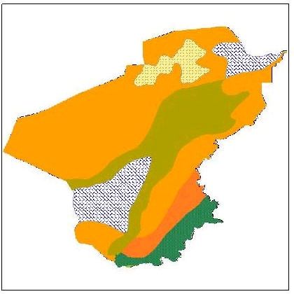
Performance of the agricultural sector in Iraq during the last two   Environmental
decades was disappointing, not only as a result of environmental     degradation in
constraints (e.g., drought) but also due to poor management and      the agricultural
                                                                     sector is a
inadequate planning and allocation of trained human resources;       serious
agricultural extension services and agricultural vocational          problem.
education, in particular, are in need of major improvements.

Iraq faces serious problems of environmental degradation that must
be addressed immediately because failure to act now will greatly
compound the cost and complexity of later remedial efforts, and
because environmental degradation is beginning to pose a major
threat to human well-being, especially among the poor.

To deal with the multiple challenges imposed upon it by internal
and external factors, the agricultural sector in Iraq has to
structurally adjust itself to address socio-economic, land-use,
livestock production and feed resources, water resources, agro-
ecology, environmental protection, and research and extension
components in a holistic, multidisciplinary and long-term manner.

                                           7
1. Introduction

Mesopotamia, the ancient land of the “twin rivers” (the Tigris and
Euphrates), with its bountiful land, fresh waters, and varying
climates, contributed to the human civilization in many ways. The
eastern limb of the Fertile Crescent was the cradle of the earliest
known civilizations and served as the cultural heart from which the
first ideas of sedentary agriculture, domestication of animals, the
wheel, writing, and urban development are believed to have
diffused westward to the Nile Valley and eastward to the Indus
Valley.

Since the beginning of recorded time, agriculture has been the
primary economic activity of the people of old Mesopotamia and
modern-day Iraq. Agriculture was the country’s major economic
activity in the 1920s; however, its contribution to the gross
domestic product (GDP) dropped to 42% in 1981 and 18% in
1990. Even so, 13% of the labor force continues to be engaged in
agriculture, more than in any other sector except services.

The land area of Iraq is 438,317 km2 , with a population of 22.8 m         Agriculture has
and a population density of 52 per km2 . Arable land as percentage         been the primary
of total land is relatively small (12%) and agriculture, in 2001,          economic activity
                                                                           in Iraq for
contributed 6.1% to the GDP. More than half (53%) of the arable            millennia. Now, it
land is rainfed, nearly all of it in the northern uplands; however,        contributes only
most of the agricultural production comes from the more                    6% of GDP and
intensively cultivated areas of the irrigated plains.                      employs 13% of
                                                                           labor force.
In the decade from 1977, Iraq was self sufficient in cereals, and
agricultural imports amounted to 22% of total imports. During
recent decades, however, Iraq has shifted from net food exporter to
food importer. This shift was prompted by several factors,
including population increase, a rising standard of living, increased
industrialization, migration of farm workers to urban centers, and
loss of soil productivity in poorly drained irrigated areas of the
south.

Increased funding for agricultural research is particularly crit ical in
Iraq. Despite this nation’s heavy dependence on agriculture, the
public expenditures on research generally total less than 0.5
percent of its agricultural gross domestic product. By comparison,
industrialized countries spend 2 to 5 percent.

Prior to 1990, Iraq had one of the highest per capita food
availability in the Middle East, because of its relative prosperity
and capacity to import large quantities of food, which met up to

                                               8
two-thirds of food requirements. After 1990, however, Iraq’s
ability to import food was significantly constrained.
Agricultural development will be a great challenge over the next Iraq is a net food
two decades in Iraq. Food requirements will double as the importer.
population continues to grow at 3.0% annually. There is an Agricultural imports
estimated 8m ha of cultivable land, but only 4-5 million ha is make up 22% of all
cultivated in any one year, and the land area under high- value imports. Iraq will
spend US$ 3.0
vegetables and fruits is relatively very small (< 0.5 million ha). In billion/year on food
order to achieve self sufficiency in cereals, Iraq has to grow wheat imports in years to
and barley on 8.1million ha. come.
The role of women in agriculture, especially in the production
process and extension, needs to be addressed, as more and more
women are involved in food production, processing and marketing.
This paper presents overviews of agricultural resources and
institutional constraints on agriculture in Iraq; and outlines
research needs and priorities for this important sector of the Iraqi
economy.
92. Regional Patterns
Iraq lies between 29°15’N, and 38°15’N, 38°45 and 48°45’E, and Iraq’s land area is
is located entirely within the north temperate zone where it enjoys 438,320 km2 ,
including 924 km2
stimulus seasonality of climate. Iraq, with a total area of 438,320 of inland waters.
km2 including 924 km2 of inland waters, is surrounded by Iran to
the east, Turkey to the north, Syria and Jordan to the west, Saudi The great alluvial
Arabia and Kuwait to the south, and the Persian Gulf to the Mesopotamian
southeast. Topographically, Iraq is shaped like a basin, consisting Plain is the main
agricultural
of the Great Mesopotamian alluvial plain of the Tigris and
producing region.
Euphrates. This plain is surrounded by mountains in the north and
the east, which can reach altitudes of 3,550 m above sea level, and
by desert areas in the south and west, which account for over 40%
of the land area. For administrative purposes, the country is
divided into 18 governorates, three of which are included in the
northern autonomous region.
2.1. Climate
The climate of Iraq is mainly of the continental, subtropical semi-
arid type, with the north and northeastern mountainous regions
having a Mediterranean climate. Rainfall occurs during the winter
months, from December to February in most parts of the country
and November to April in the mountains, with average day
temperature of 16°C dropping at night to 2°C with a possibility of
frost. Summers are dry and hot to extremely hot, with a shade
temperature of over 43°C during July and August, yet dropping at
night to 26°C. Rainfall is highly erratic in time, quantity and
locations, and ranges from less than 100mm in the south and
southwest to about 1,000 mm/year in the north and northeast. The
substantial variation in amount and distribution of rainfall
increases the risk to rainfed crop production.
Roughly 90% of the annual rainfall occurs between November and
April, most of it in the winter months from December through
March. The remaining six months, particularly the hottest ones of
June, July, and August, are dry.
Except in the north and northeast, mean annual rainfall ranges
between 100 and 170 mm. Data available from stations in the
foothills and steppes south and southwest of the mountains indicate
that mean annual rainfall ranges between 350 and 600 mm for that
area. Annual rainfall in the mountains is more abundant and may
reach 1000 mm in some locations, however, the terrain precludes
extensive cultivation. Cultivation on non- irrigated land is limited
essentially to the mountain valleys, foothills, and steppes, which
10may receive 300 mm of annual rainfall. Even in this zone only one
crop a year can be grown, and shortages of rain have often led to
crop failures.
Average precipitation for the whole country (1961-1990) was 216
mm/year or 94.7 km3 /year. Total internal renewable water The climate varies
from Mediterranean
resources amounted to 35.3 km3 /year during the same period. to continental &
Agricultural water use was 92% of all water resources or 39.38 sub-tropical, semi-
km3 /year. arid type.
Mean minimum temperatures in the winter range from near Rainfall varies from
1,000 mm
foothills and the western desert to 2-5°C in the alluvial plains of in the northeast.
southern Iraq. Temperatures rise to a mean maximum of about
15.5°C in the western desert and the northeast, and 16.6°C in the Temperature drops
south. During summer, mean minimum temperatures range from to below zero °C in
about 22.2°C to about 29°C and rise to maximums roughly the north and
reaches ~ 50°C in
between 37.7 and 43.3°C. Temperatures sometimes fall below
the south
freezing, and as low as -14.4°C at Rutbah in the western desert.
Maximum temperatures are more likely to reach 46°C in the
summer months, and several stations have records of over 48°C.
The summer months are marked by two kinds of wind phenomena.
The southern and southeasterly Sharqi, a dry, dusty wind with
occasional gusts of eighty kilometers an hour, occurs from April to
early June and again from late September through November. It
may last for a day at the beginning and end of the season but for
several days at other times. This wind is often accompanied by
violent dust storms that may rise to heights of several thousand
meters and close airports for brief periods. From mid-June to mid-
September the prevailing wind, called the Shamal, is from the
north and northwest. It is a steady wind, absent only occasionally
during this period. The very dry air brought by this Shamal permits
intensive sun heating of the land surface, but the breeze has some
cooling effect.
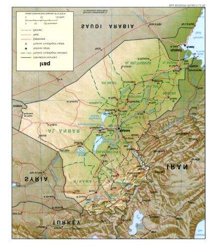
11Fig. 1. Map of Iraq showing political boundaries and
physiographic features in the country.
The combination of rain shortages and extreme heat makes much
of Iraq a desert. Because of very high rates of evaporation, soil and
plants rapidly lose the little moisture obtained from the rain, and
vegetation may not survive without extensive irrigation. Some
areas, however, although arid, do have natural vegetation in
contrast to the desert. For example, in the Zagros Mountains in
northeastern Iraq there is permanent vegetation, such as oak trees,
and date palms are found in the south.
In winter, this inflow is frequently interrupted by cyclonic
activities, a part of the irregular westerly circulation of middle
latitudes which penetrates deep in the southern parts of the
country. The yearly average number of these east-moving cyclones
amounts to 120. Most precipitation is associated with these weak
cyclones.
12Occasionally, a well-developed cyclone may remain stagnant over
the country for several days. This draws in large bodies of
maritime air, associated with considerable amounts of rain in the
lowlands, and heavy snowfall in the mountains. In general, there is
a gradual increase in rainfall in a north-east direction, from 50mm
in the south-western corner to about 1000 mm in the high
mountainous area of the northeast. Precipitation in the mountains is
influenced by a combination of cyclonic activity and orographic
barriers. The 200 mm isohyet, in general, indicates the southern
limits of the rain- fed agricultural zone. Large daily and annual
temperature amplitudes are pronounced continental climatic
characteristic. Annual average temperature in Baghdad is 22.5°C
and mean daily minimum temperature in January is 4°C. Mean
maximum temperature in August is 43.2°C. Air humidity is rather
low; in Baghdad, the relative humidity in August ranges from 20 to
45 percent.
The climate of Iraq, in terms of temperature and rainfalls, may be
classified into three main types.
2.1.1. Mediterranean Climate
This type is characterized by cool wet winters and hot dry
summers. It is more restricted to the mountainous areas; therefore,
snowfall is not uncommon and the amount of rainfall varies from
400mm at lower altitudes to 1,000mm at higher altitudes. Average
summer temperature do not exceed 35° C on the lower slopes, but
it is much less on higher slopes.
2.1.2. Steppe Climate
This type is transitional one between the Mediterranean type in the
north and the desert in the south. High temperature and small
amounts of rain are the main limiting factors. Annual rainfall
ranges from 200mm to 400mm. It comes during the cool season of
the year when the evaporation rate is the lowest. This is a natural
pasture area; large sheep flocks are grazed during late winter to
mid summer time.
2.1.3. Hot Desert Climate
The climate of the lowlands of Iraq is a typical desert climate. This
is an area of a high thermal energy. With clear sky during summer,
air temperature rises to a maximum of 45-50° C. with a wide range
13in daily temperature. Nights are rather cool. In winter times, warm
and sunny weather prevails, and the temperature rarely drops
below freezing point.
2.2. Physiography
Mountains, plateaus, hills and valleys, planes and inland water-
covered areas are the major geomorphic forms, which, in varying
combinations, constitute the topography of Iraq. These geomorphic
forms exe rt a strong influence upon the cultural and economic
patterns of the country and, together with the climate, provide a
permanent back-drop against which the history of Iraq is enacted.
A mountain movement started 50 to 30 million years ago, and a
series of sedimentary beds, lying at the bottom of the shallow sea,
has been regularly bent into arches and troughs; that is, into
anticlines and synclines. The arches formed the mountains and
troughs formed the valleys. The mountain building movement is
still going on, but at a very slow rate. During the three main pluvial
periods in Iraq, concurrent with glacial ages in Europe, climate was
more humid than at present and a considerable period of river
erosion modified the land surface. The mountains were cut down
and the valleys as well as the southern part of the extensive
geosynclines were filled up with pebbles, gravel, sand, silt and
clay. Inter-pluvial phases, with a climate similar to that of the
present time, interrupted the erosional process, and river terraces
have been formed along the rivers and their tributaries in central
and northern Iraq. Three broad erosional river terraces, for
example, can be seen in Tikrit along the eastern banks of the
Tigris.
Four broad altitudinal topographic regions can be distinguished in
Iraq. These are:
2.2.1. Mountain Region
Bold, majestic mountains cover an area of 92,000 km2 , or about 21
percent, of the total area. The mountain region extends mainly in
the northern and north-eastern parts of the country. The mountains
consist mainly of parallel anticline ridges separated by elongated
synclinal valleys. But they are united by narrow gorges, the outlets
of the drainage of the interior basins. The mountains, for the
greater part, are eroded and the detritus material has been
deposited in the valleys and in the area in front of the mountains.
The mountains are comprised of various folded limestone layers
varying from simple folding in the south to complicated folding in
14the north. Sindy, Zab and Rawandooz geosynclines separate these
two parts. The average elevation of the former, ranges from 1,700 Northern mountains
to 2,000 meters, while it reaches an elevation of 2,300 to 3,000 make up 21% of
land area. Highest
meters in the latter. Faults, metamorphic rocks, and glacial peak is 3,607 m.
landforms are not uncommon in this area. The highest mountain
peak in the country is Hassarrost; it stands 3,607 meters above sea Mostly covered with
level. forest trees and
grazing grounds
Fig. 2. Land forms in Iraq.
Uplands, piedmont, and rugged mountains rising northeast of the
upper Tigris in Iraq exhibit a sharp contrast to the desert plains
areas that cover most of the rest of the country.
The highest ridges contain Iraq’s only forests, some of them quite
extensive, preserved by the isolation and ruggedness of the area.
Most of the mountain slopes permit only grazing, lower and more
gentile slopes support fruit and nut trees, and the broad valley
bottoms are intensively cultivated.
Water- falls, cascades, rapids and deep gorges are common
geomorphic phenomena in the area. Plains of a considerable size,
such as Rania and Shahrazoor, separate two mountain areas. The
former is a kidney-shaped plain, in the Lesser Zab area, with an
elevation ranging from 500 to 700 meters. It extends for 30 km and
its width varies from 20 to 30 km. A basin- like Shahrazoor plain
15varies in elevation from 400 to 700 meters above sea level and
extends for 45 km from east to west, while its narrowest width is
about 50 km.
2.2.2.Undulating Lands
This area is comprised of a fairly hilly landscape, located south and
west of the mountain region. It covers an area of about 42,000 km2 ,
or nearly 9.6% of Iraq's total area. Although there are some
similarities with the former region, general landscape differences
stand sharp. The area is somewhat folded in the later phase of
folding. It consists of low parallel hill ridges, wide shallow valleys
and extensive plains, in which various streams have cut their
valleys. In general, average altitude varies from 200 to 1,000 The undulating
meters. Local relief ranges from a minimum of 200 to a maximum lands cover 9.6%
of 800 meters per square kilometer. Beds of gravel, conglomerate of Iraq. They
and sandstone make up the area. It can be divided, in terms of make up the major
rainfed
geomorphic landforms structure, surface rocks and degree of agricultural area.
erosional process, into a number of plains, plateaus, mountains and
hill ridges. A briefly discussed example of each may summarize
the whole picture of the region.
The mountains are relatively low. Sinjar mountain, west of Mosul,
is an anticline range extending in a north-easterly direction. Its
elevation varies from 900 to 1600 meters above sea level. The
southern edge of the mountain range is a highly dissected part.
Strike valleys and minor scraps are common.
Plateaus are small in number, and the best known are those of
Mosul and Kirkuk. The surface of Mosul plateau is dissected by
shallow valleys with hills rising to 400 meters above the
surrounding valley bottoms.
Plains are found within the area such as the plains of Sinjar and
Arbil. The latter is a synclinal triangular basin filled with alluvium
deposits. Its elevation varies from about 600 m at the eastern edge
to 350 m at the western parts. Fertile soils together with an
adequate amount of winter rain provide a good basis for
agricultural land use. Wheat and barely are the main crops in
winter, while underground water resources supply enough
irrigation water for many agricultural crops during summer.
Crops such as wheat, barley, sugar beet, cotton, vegetables, and
fruits, dairy products, and agricultural industries (e.g., sugar,
cotton, woolen textiles, etc.) form the basis of a solid agricultural
economy. During winter, a significant growth of annual grasses
16and legumes, depending on rainfall, provides good natural pasture
for sheep, goats and cattle.
2.2.3. The Depositional Plain
The cultural and economic core of ancient and modern-day Iraq
evolved in the southern Mesopotamian alluvial plains, along and
between the lower courses of the Tigris and Euphrates. Ancient
empires thrived, and the ruins of most ancient cities of the Old The Mesopotamian
World still stand in this part of the country. plain is the cultural
and economic core
Temperatures during the dry summers average 35°C for July and of ancient and
modern-day Iraq. It
soar to daytime highs of 50°C. The plains drop from 80 m above covers 30% of the
sea level near Baghdad to sea level near Basra in the south. land area and
produces most of its
Southeast of the Baghdad area, the central interfluve is mostly crops under
wasteland or marshes that become desiccated in the dry, hot irrigation.
summers. A high water table and inadequate drainage on some of
these deltaic silt lands combine to raise soil salinity to levels that
prevent cultivation of otherwise fertile soils that could be irrigated
if adequate drainage could be maintained.
It is the plain of the twin rivers, the Tigris and the Euphrates,
referred to in ancient times as Shinar and later on called Al-Sawad
(i.e., black lands), because of its high agricultural productivity. The
plain is located in central and southern Iraq with a number of
distinct landscapes. The undulating lands are to the north, the
western plateau to the west, Zagros mountains to the east and the
Persian Gulf to the south. The plains (including marshland and
lakes) cover an area of 132,500 km2 , or 30.2% of the total area of
Iraq. It has a northwest-southeast orientation, trending in the same
direction of the Tigris, Euphrates and Shatt al-Arab.
Most of the uplands, extending from Syria into central Iraq, are a
desert plateau descending from 450 m in the northeast to 80 m near
Baghdad. Except for the river floodplains and for the segment
northwest of Mosul, population is sparse and development
relatively limited. The undulating plateau in the north is devoted to
rainfed cultivation of wheat and barley. Iraqi development plans
envision later development of this part of the country, including
appreciable irrigation, comparable to that undertaken by Syria.
Geologically, the plain occupies the southern part of an extensive
geosycline. It was filled up during the quaternary and recent
geological periods. Besides sediments carried by the twin rivers,
some material of aeolian origin, blown out of the desert, is
17accumulated and mixed with fluvial deposits. As a result of flood
and irrigation, rather thick layers of mud have been deposited on
top of the original soils. Nearly the whole plain is now covered by
this silty material.
Along the eastern borders, rivers tumbling down from the eastern
mountains helped to form a number of alluvial fans. A series of
adjacent fans coalesced to form an extensive piedmont alluvial
plain. The material comprising these fans varies in texture, from
coarse boulders and pebbles at its head to fine material down its
slope. Mendile and Basra are located on such alluvial fans. Here is
a good example of a successful agricultural land use. Gentle
slopes, fertile loamy soils, good air drainage in winter and flow
irrigation were utilized to grow date palms and citrus fruits.
Most of the plain appears to be dead flat. In areas away from rivers
or cultivated land, one may look to the full circle of the horizon
without seeing any perceptible slope. But natural levees, irrigation
canals, and low lying hills may break the monotony of the land.
Rivers flow with a gentle gradient and are unable to carry all their
load of sediment. For this reason, natural levees capped with dikes
border the Tigris and Euphrates. Flow irrigation canals can be
easily led away from the rivers. Many parts of the plain have poor
drainage, especially in the basin- like area in its southern part north
of Basra.
Marshlands used to occupy an area of more than 35,000 km2 . Their
geographic distribution may be seen in three distinct groups. The
first stretches east and west of the Tigris, the second is Al- Hammar
lake, and the third stretches between the Hilla canal and the
Euphrates.
Reeds and bushes thickly cover the banks and shallow portions of
the marshes. These provide an excellent nestling grounds for
migrating birds in winter. The main crops grown on the marsh
borders are rice, millet and tomatoes, while animal husbandry is
restricted to raising buffaloes. The marshes, a
unique ecosystem,
A natural wetland vegetation typically covered the bulk of the covered ~ 35,000
k m2 in southern Iraq
marshes. Common reed (Phragmaites communis) dominated the before they were
core of the permanent marshe s, gradually yielding to reed mace drained in the late
(Typha augustata) in the ephemeral seasonal zone. Temporarily 1990s.
inundated mudflats are overgrown with salt-tolerant vegetation of
low sedges and bulrush (Carex and Juncus spp., Scripus
brachyceras). Deeper, permanent lakes support rich submerged
aquatic vegetation typified by species such as hornwort
18(Ceratophyllum demersum) eel grass (Vallisneria spp.) and
pondweed (Potamogeton lucens), as well as bottom vegetation
such as stonewart (Chara spp.). In the smaller lakes and back
swamps, floating vegetation of water lilies (Nymphaea and Nuphar
spp.), water soldier (Pistia stratiotes) and duck weed (Lemna
gibba) are common.
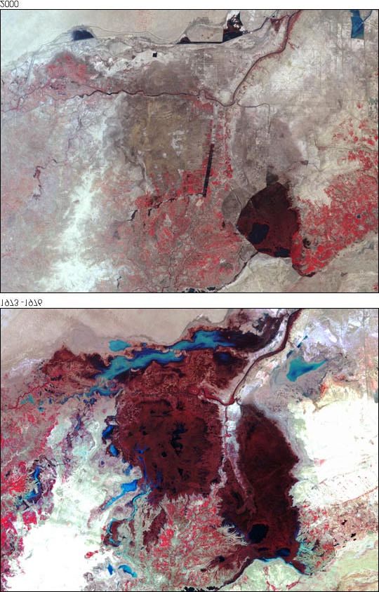
Fig. 3. Marshlands in Iraq before (upper) and after (below) they
were drained.
As a major haven of regional and global biodiversity, the
marshlands support significant populations and species of wildlife.
Recently, however, and after large parts of the marshes were
drained, the number of endangered species of birds, mammals and
fish were estimated at 11, 5, and 1, respectively.
192.2.4. The Western Plateau (Semi-desert)
This extension of the Syrian and Arabian deserts lies west of the
Euphrates Valley and comprises the barren western third of Iraq. It
is the realm of Iraq’s few thousand remaining Bedouins and least
populated and least developed part of the country.
This is the largest physiographic region in the country. It occupies The western plateau
an area of 171,817 km2 , or about 39.2% of Iraq’s total area. The is desert, semi-
surface rises gradually from 120 m in the east to 700 m in the west. desert, and natural
grazing grounds. It
Surface drainage takes a general west-east direction, but streams occupies 39.2% of
bring large amounts of water from Sinjar mountain to be drained the land area.
southward to the Wadi Tharthar, which has been used to store
excess Tigris water diverted near the Samarra Barrage. It was
lately connected with the Euphrates and the Tigris by two feeding
canals to divert enough irrigation water back to both rivers.
Within this very extensive region, there are a number of different
plains; Al-Widian (valleys), Jezira (island), al-Hijara (rock), al-
Hamad and Dibdibba. The differences are based on physical
factors such as relief and rock formations.
Al-Widian Plain developed in an area of limestone and gypsum
rock ranging from level to undulating with shallow to rather deep
valleys. In the northern Widian area is the large Ga'ara depression
north of Rutba.
The Jezira is what has remained of an old inland sea. It is a
dissected up land area across which the rivers flow in a well-
developed valley. At present it is a large desert and steppe area. In
winter and spring, especially after a good rainy season, the
northern portion is covered by desert grasses which provide
grazing grounds for camels and sheep. There are many saline
lakes, marshes and depressions in this region, with Wadi Tharthar
as the largest one.
Al-Hijara is a flat, stony plain with some shallow valleys. Al-
Hamad plain is at the extreme western corner of the country. It
developed on limestone bedrock formations. The plain is nearly
level and featureless. Dibdibba plain occupies the southern portion
of this region west of Basra. It developed on sand and gravel and
the surface varies from level to slightly rolling land
Landforms of wrappings, foldings and faults are found throughout
the region. Al- Ga'ara and Al-Salman basins occupy eroded domes,
while geomorphic arid landforms are found in many localities.
20Buttes and mesas are characteristics of isolated remnants of hard
resistant limestone. Sand dunes 30 meters high, as well as low
volcanic ones, are typical desert features.
2.3. Population
Iraq’s estimated population of 22.8m, of which 25% is rural, in
2001 marked a 360 percent increase over 1947. This growth has
occurred primarily through natural increase. Iraq’s population is
concentrated in linear patterns along the banks of rivers and canals
on the plains but is more generally distributed in the villages and
towns of the northeastern uplands and mountains. Average
population density is estimated at 47 inhabitants/km2 , but ranges
from 5 inhabitants/km2 in the western (desert) part of the country,
to more than 170 inhabitants/km² in the Babylon province, in the
centre of the country. Population density is expected to reach 97
inhabitants/km2 by the year 2025.
The average population growth was estimated at 3.6% during Iraq’s population
1980-90, but emigration of foreign workers and severe economic is 22.8 m and
hardships have reduced this growth rate since 1990. In 1989, the growing at 3.6%
agriculture sector contributed only 5% to GDP, which was per year. Rural
dominated by oil (61%). About 20% of the labor force is engaged population ~ 25%.
in agriculture Population
density ranges fro
The greatest single concentration of population, about 50% of the 5 to 170 person/
total, begins north and west of Baghdad, sprawls westward and km2. It will
southward across the mid-Iraq interfluve, and then follows the double in the next
20 years.
Euphrates and its various branches along the west side of the
alluvial plain to the city of Samawah. Metropolitan Baghdad alone
has one-third of Iraq’s population. The middle Euphrates
concentration has a well-balanced economy, based on agriculture,
industry, trade, and tourism.
Secondary concentrations of population are found in the south,
normally along Shat Al-Arab, with Basra as its largest city; in the
north around Mosul; and in the northeast piedmont, around the oil
developments in Kirkuk and the ancient city of Arbil. The
remaining parts of the country are comparatively sparsely
populated, with some 75% of the population living in urban
centers.
21Fig. 4. Population density in Iraq.
2.3.1. Settlement Patterns
In the rural areas of the alluvial plain and in the lower Diyala
region, settlements almost invariably cluster near the rivers,
streams, and irrigation canals; the levees, laid down by streams and
canals, proved to be advantageous for both settlements and
agriculture. Surface water drains more easily on the levees'
backslope, and the coarse soils of the levees are easier to cultivate
and permit better subsurface drainage. The height of the levees
gives some protection against floods and the frost that often affect
low- lying areas and may kill winter crops. Above all, those living
or cultivating on the crest of a levee have easy access to water for
irrigation and household use in this dry, hot country.
Although there are some isolated homesteads, most rural
communities are nucleated settlements rather than dispersed
farmsteads; that is, the farmer leaves his village to cultivate the
fields outside it. The pattern holds for farming communities in the
Kurdish highlands of the northeast as well as for those in the
alluvial plain. The size of the settlement varies, generally with the
volume of water available for household use and with the amount
of land accessible to village dwellers. Sometimes, particularly in
the lower Tigris and Euphrates valleys, soil salinity restricts the
area of arable land and limits the size of the community dependent
22on it, and it also usually results in large unsettled and uncultivated
stretches between villages.
Fragmentary information suggests that most farmers in the alluvial
plain tend to live in villages of over 100 persons. For example, in
the mid-1970s a substantial number of the residents of Baqubah,
the administrative center and major city of Diyala Governorate,
were employed in agriculture.
The Marsh Arabs (the Madan) of the south usually live in small
clusters of two or three houses kept above water by rushes that are
constantly being replenished. Such clusters often are close
together, but access from one to another is possible only by small
boats. Here and there a few natural islands permit slightly larger
clusters. Some of these people are primarily water buffalo herders
and lead a semi- nomadic life. In the winter, when the waters are at
a low point, they build fairly large temporary villages. In the
summer they move their herds out of the marshes to the river
banks. Before the Marshes were drained, the lifestyle of the Madan
centered around agriculture, particularly cultivating rice and dates,
weaving read mats, raising water buffalo, and fishing. A form of
local commerce had developed involving mostly local trade,
supported by the use of small boats for transportation.
During the last two decades, and especially in the 1990s, the
Madan have either migrated to settled communities away from the
marshes or have been forced by government decree to relocate
within the marshes.
Similarly, settlement patterns in the northern Kurdish areas have
been affected during the last two decades; as a result, rural Kurds
flocked into the regional centers of Arbil and Sulaymaniyah. The
majority of Kurdish villages, however, remained intact.
In the arid parts of Iraq to the west and south, cities and large
towns are almost invariably situated on watercourses, usually on
the major rivers or their larger tributaries. In the south, this
dependence has had its disadvantages. Until the recent
development of flood control, Baghdad and other cities were
subject to the threat of inundation. Moreover, the dikes needed for
protection have effectively prevented the expansion of the urban
areas in some directions. The growth of Baghdad, for example,
was restricted by dikes on its eastern edge. The diversion of water
to the Tharthar depression and the construction of a canal
transferring water from the Tigris north of Baghdad to the Diyala
River have permitted the irrigation of land outside the limits of the
dikes and the expansion of settlements.
233. Land and Water Resources
3.1. Land Resources
It is estimated that 11.48 million hectares, or 26% of the total area
of the country, are cultivable. The total area estimated to be used
for agriculture is 8 million ha, which is almost 93% of the
cultivable area. However, due to soil salinity, fallow practices and
the unstable political situation it is estimated that only 3 to 5 Cultivable area ~
million ha are actually cultivated annually. In 1993, the area 11.48 m ha.
actually cultivated was estimated at about 3.73 million ha, of Land area actually
which 3.46 million ha consisted of annual crops and 0.27 million cultivated ~ 3-5 m
ha consisted of permanent crops. ha.
3.2. Land Use Irrigated area ~ 1.9
m ha.
Historically the most significant types of land use and food
production in Iraq have been irrigated agriculture, which requires
substantial investment and is an intensive form of land use; and
pastoralism, which requires relatively little investment and is
extensive. These have been combined with dryland farming in the
semi-arid areas of northern Iraq. Although these basic types are
technologically very different, they have been closely interrelated,
socially and economically, for thousands of years.
Historical evidence shows some significant declines in production
from time to time during the last five thousand years, but the
causes (which appear in most cases to have involved a combination
of both human and natural factors) have not been reconstructed
convincingly. The old Mesopotamian systems, as well as the new
one in present-day Iraq, have gone through several cycles of
growth and decline.
Environmental problems in development generally derive not from
basic technologies such as types of irrigation or grazing, but from
the scale of the productive activity in relation to the resource.
Before the first attempt to develop irrigation in modern-day Iraq,
irrigation (which probably developed in its most primitive form not
long after the domestication of plants and animals, some ten
thousand years ago elsewhere in Mesopotamia) had already served
as the basis of vast agricultural projects, and had had
environmental effects which reduced productivity seriously. The
best known example is from Mesopotamia; it was generally
restricted to flood plains and was seasonal, depending on the
annual flooding of the Tigris and Euphrates.
24Fig. 5. Arable land area in Iraq during the period 1961-2000.
Perennial irrigation in Iraq, which requires storage and gradual
release of the water through the period of minimum flow, is largely
the introduction of the 20th century. Such irrigation has allowed
major increases in areas under cultivation and intensification of
cropping but it also magnifies the adverse effects of irrigation: soil
salinity and waterlogging develop faster and some of the adverse
effects are more difficult to reverse.
3.3. Land Degradation
More than 50% of Iraq’s land area is desert, and an increasing part
of the permanent pasture areas is subject to erosion because of
reduced vegetation cover. Additionally, much of the cropland is
losing its inherent productivity due to poor agricultural practices
and over exploitation. The direct loss of agricultural land is most
acute around urban centers, where established agricultural land is
being lost to alternative uses, including urbanization,
industrialization, and transport infrastructure. To compensate for
this, new land is being brought into production through
reclamation. The productivity of the reclaimed land, however, is in
many cases only a fraction of the old, and new land is being
brought into production more slowly than old land is being lost.
Overgrazing in desert areas is a major cause of plant cover loss,
particularly in the semi-desert, which suffered a particularly severe
25loss of vegetation as a result of overgrazing, off-road vehicles,
construction, and tourist activities.
3.4. River Basins
There is only one river basin in Iraq, the Shatt Al-Arab basin. The
Shatt Al-Arab is the river formed by the confluence downstream of
the Euphrates and the Tigris which flows into the Persian Gulf
after a course of only 190 km. Before their confluence, the
Euphrates flows for about 1,000 km and the Tigris for about 1,300
km, respectively, within the Iraqi territory. Nevertheless, due to the
importance of the Euphrates and the Tigris, the country is
generally divided into three river basins: the Tigris, the Euphrates,
and the Shatt Al-Arab.
Fig. 6. Land degradation in Iraq during the period 1981-83 and
1991-93, as compared to other countries in West Asia.
3.5. Surface Water Resources
Water resources in Iraq are controlled by the twin rivers, the Tigris
and the Euphrates. Both are international rivers originating their
source in Turkey. The Tigris river basin in Iraq has a total area of
253,000 km², or 54% of the total river basin area.
26The average annual flow of the Euphrates as it enters Iraq is
estimated at 30 km³, with a fluctuating annual value ranging from
10 to 40 km³. Unlike the Tigris, the Euphrates receives no
tributaries within Iraq’s borders.
For the Tigris, average annual runoff as it enters Iraq is estimated
at 21.2 km³. All upstream and downstream tributaries of the Tigris
are on its left bank; these are:
• The Greater Zab, which originates in Turkey and is partly
regulated by the Bakhma dam. It generates 13.18 km³ at its
confluence with the Tigris; 62% of the 25,810 km² of river
basin is in Iraq;
• The Lesser Zab, which originates in Iran and is equipped
with the Dokan dam (6.8 km³). The river basin of 21,475
km² (of which 74% is in Iraqi territory) generates about
7.17 km³ of water;
• Al-Adhaim (Great River), which drains about 13,000 km²
entirely in Iraq. It generates about 0.79 km³ at its
confluence with the Tigris. It is an intermittent stream
subject to flash floods;
• Diyala, which originates in Iran and drains about 31,896
km², 75% of which is in Iraqi territory. It is equipped with
the Darbandikhan dam and generates about 5.74 km³ at its
confluence with the Tigris;
• Nahr Al- Tib, Dewarege and Shehabi rivers, with a
combined draining of more than 8,000 km². They originate
in Iran and bring together in the Tigris about 1 km³ of
highly saline waters;
• Al-Karkha, whose course is mainly in Iran and, from a
drainage area of 46,000 km², brings about 6.3 km³ yearly
into Iraq, namely into the Hawr Al Hawiza during the flood
season, and into the Tigris river during the dry season.
The Karun river, originating in Iran flows with its mean annual
flow of 24.7 km³ into the Shatt Al-Arab. It brings a large amount
of fresh water into the Shatt Al-Arab just before it reaches the
Persian Gulf.
The Euphrates and the Tigris are subject to large and possibly
disastrous floods. The level of water in the Tigris can rise at the
rate of over 30 cm/hour. In the southern part of the country,
immense areas are regularly inundated, levees often collapse, and
villages and roads must be built on high embankments. The
Tharthar reservoir was planned inter alia in the 1950s to protect
Baghdad from the ravages of the periodic flooding of the Tigris.
27You can also read