The ARCHES Space-Analogue Demonstration Mission: Towards Heterogeneous Teams of Autonomous Robots for Collaborative Scientific Sampling in ...
←
→
Page content transcription
If your browser does not render page correctly, please read the page content below
IEEE ROBOTICS AND AUTOMATION LETTERS. PREPRINT VERSION. ACCEPTED JUNE, 2020                                                                                     1

        The ARCHES Space-Analogue Demonstration
          Mission: Towards Heterogeneous Teams of
            Autonomous Robots for Collaborative
         Scientific Sampling in Planetary Exploration
Martin J. Schuster1 , Marcus G. Müller1 , Sebastian G. Brunner1 , Hannah Lehner1 , Peter Lehner1 , Ryo Sakagami1 ,
   Andreas Dömel1 , Lukas Meyer1 , Bernhard Vodermayer1 , Riccardo Giubilato1 , Mallikarjuna Vayugundla1 ,
        Josef Reill1 , Florian Steidle1 , Ingo von Bargen1 , Kristin Bussmann1 , Rico Belder1 , Philipp Lutz1 ,
        Wolfgang Stürzl1 , Michal Smı́šek1 , Moritz Maier1 , Samantha Stoneman1 , Andre Fonseca Prince1 ,
        Bernhard Rebele1 , Maximilian Durner1 , Emanuel Staudinger2 , Siwei Zhang2 , Robert Pöhlmann2 ,
    Esther Bischoff3 , Christian Braun3 , Susanne Schröder4 , Enrico Dietz4 , Sven Frohmann4 , Anko Börner4 ,
   Heinz-Wilhelm Hübers4 , Bernard Foing5 , Rudolph Triebel1 , Alin O. Albu-Schäffer1 , and Armin Wedler1

   Abstract—Teams of mobile robots will play a crucial role
in future missions to explore the surfaces of extraterrestrial
bodies. Setting up infrastructure and taking scientific samples
are expensive tasks when operating in distant, challenging,
and unknown environments. In contrast to current single-robot
space missions, future heterogeneous robotic teams will increase
efficiency via enhanced autonomy and parallelization, improve
robustness via functional redundancy, as well as benefit from
complementary capabilities of the individual robots. In this
article, we present our heterogeneous robotic team, consisting
of flying and driving robots that we plan to deploy on scientific
sampling demonstration missions at a Moon-analogue site on Mt.
Etna, Sicily, Italy in 2021 as part of the ARCHES project. We
describe the robots’ individual capabilities and their roles in two
mission scenarios. We then present components and experiments
on important tasks therein: automated task planning, high-level                   Fig. 1: Our Lightweight Rover Units (LRUs) [5] and drone
mission control, spectral rock analysis, radio-based localization,                ARDEA [7] test their skills for autonomous navigation, ex-
collaborative multi-robot 6D SLAM in Moon-analogue and Mars-
like scenarios, and demonstrations of autonomous sample return.
                                                                                  ploration, and sampling at a Moon-analogue site on Mt. Etna.

  Index Terms—Space Robotics and Automation; Multi-Robot
Systems; Autonomous Agents
                                                                                                             I. I NTRODUCTION

   Manuscript received: February, 24, 2020; Revised May 19, 2020; Accepted
June 16, 2020.
   This paper was recommended for publication by Editor Jonathan Roberts
                                                                                  T     EAMS of mobile robots that operate on the surfaces
                                                                                        of extraterrestrial bodies will play a crucial role in
                                                                                  future space exploration endeavors [1], [2]. Compared to
upon evaluation of the Associate Editor and Reviewers’ comments. This             current single-robot missions, they will improve efficiency via
work was supported by the Helmholtz Association, project alliance ROBEX
(contract number HA-304) and project ARCHES (contract number ZT-0033).
                                                                                  parallelization and robustness via functional redundancy. In
   1 M. J. Schuster, M. G. Müller, S. G. Brunner, H. Lehner, P. Lehner, R.       addition, heterogeneous teams benefit from complementary
Sakagami, A. Dömel, L. Meyer, B. Vodermayer, R. Giubilato, M. Vayugundla,        capabilities of their individual agents [3], [4]. However, several
J. Reill, F. Steidle, I. von Bargen, K. Bussmann, R. Belder, P. Lutz, W.
Stürzl, M. Smı́šek, M. Maier, S. Stoneman, A. Fonseca Prince, B. Rebele,
                                                                                  key tasks in lunar and planetary exploration missions, such
M. Durner, R. Triebel, A. O. Albu-Schäffer, and A. Wedler are with the Inst.     as infrastructure installation and scientific sampling, remain
of Robotics and Mechatronics, German Aerospace Center (DLR), Germany              challenging: robots operating in Global Navigation Satellite
{first.lastname@dlr.de}
   2 E. Staudinger, S. Zhang, and R. Pöhlmann are with the Inst. of Commu-       System (GNSS)-denied environments have to rely on space-
nications and Navigation, DLR, Germany {first.lastname@@dlr.de}                   suitable on-board sensors to navigate, explore, and sample
   3 E. Bischoff and C. Braun are with the Inst. of Control Systems, Karlsruhe
                                                                                  unknown areas in rough terrain. Long round-trip times, rang-
Institute of Technology (KIT), Germany {first.lastname@@kit.edu}                  ing from seconds (Moon) to many minutes (Mars), render
   4 S. Schröder, E. Dietz, S. Frohmann, A. Börner, and H-W.
Hübers are with the Inst. of Optical Sensor Systems, DLR, Germany                direct teleoperation impractical to impossible. Thus, local
{first.lastname@@dlr.de}                                                          robot autonomy is required as the basis for any coordinated
   5 B. Foing is with the European Space Research and Technology Centre (ES-
                                                                                  joint action within the team. For this, the robots need to
TEC) & International Lunar Exploration Working Group EuroMoonMars, Eu-
ropean Space Agency (ESA), Netherlands {Bernard.Foing@esa.int}                    localize themselves online, map their surroundings, and share
   Digital Object Identifier (DOI): 10.1109/LRA.2020.3007468                      information about the environment and their position therein.
 c 2020 IEEE. Personal use of this material is permitted. Permission from IEEE must be obtained for all other uses, in any current or future media, including
reprinting/republishing this material for advertising or promotional purposes, creating new collective works, for resale or redistribution to servers or lists, or
reuse of any copyrighted component of this work in other works.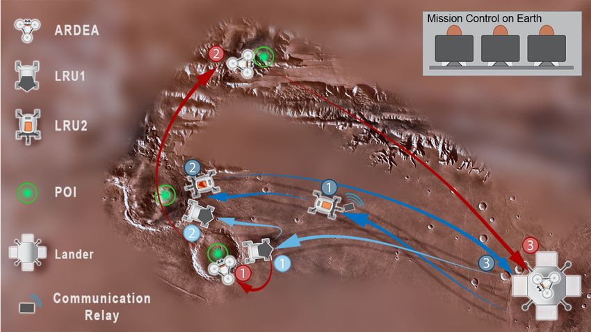
2                                                            IEEE ROBOTICS AND AUTOMATION LETTERS. PREPRINT VERSION. ACCEPTED JUNE, 2020

   In the ARCHES project by the Helmholtz Association,                    robotic team will primarily operate in full autonomy governed
we develop heterogeneous, autonomous, and interconnected                  by a complex mission control framework. The authors of [15]
robotic systems and technologies to tackle these challenges [8].          present a multi-robot coordination framework to map planetary
We will show their capabilities during demonstration missions             caves. However, they employ rather simple wheeled/tracked
in the summer of 2021 at a Moon-analogue site on the volcano              robots evaluated in generic artificial environments. In contrast
Mt. Etna on Sicily, Italy.1 While in ROBEX [9], a single robot            to the LIDAR-based vision in [3], [4], [13], [15], we use stereo
deployed a seismic sensor array, we focus in ARCHES on                    cameras as a space-qualifiable sensor setup. Furthermore, our
the cooperation in a heterogeneous team. Our robotic team                 goal is to deploy a robot team at an outdoor Moon-analogue
includes a drone for fast scouting and rovers with scientific             site to explore, deploy sensors, and perform scientific analyses.
instruments and manipulation capabilities for infrastructure
installation, close-up analyses, and sample return. In Fig. 1,                       III. H ETEROGENEOUS ROBOTIC T EAM
we give an impression of our preliminary experiments at the                  Our heterogeneous robotic team consists of flying and driv-
test site conducted in 2017 and 2019. In this article, we present         ing robots as well as static and mobile infrastructure elements
   • our heterogeneous robotic team and its capabilities                  such as a lander and multi-purpose payload boxes [9], [17].
   • two mission scenarios: the setup of a distributed radio              While drones on extraterrestrial bodies [2] require adaptions to
       telescope as well as geological exploration and sampling           their propulsion systems, e. g., realized by the Mars helicopter
   • experiments testing key components for the missions                  “Ingenuity” to be launched this summer [18], our drone allows
It is in parts based on our IROS 2019 workshop paper [10]. In             us to implement and test transferable navigation and visual
addition to extended descriptions of central aspects, we present          detection algorithms. We provide an overview of all systems
novel contributions going beyond the workshop:                            in Table I. The robots benefit from their complementary
   • mission scenario for the installation of a low-frequency
                                                                          capabilities: our drone ARDEA [6], [7] acts as a fast scout
       radio array (LOFAR) and a radio-based localization of              that can easily reach hard-to-access places such as craters or
       the array elements via our novel Radio-CPT system                  caves, whereas our first planetary exploration rover LRU1 [5]
   • high-level mission control with automated task planning,
                                                                          performs close-up inspections with its science camera and can
       multi-robot monitoring and coordination, autonomous                transport ARDEA for energy efficiency reasons. Our second
       task execution, and shared robot autonomy                          rover, LRU2 [5], [16] with its manipulator arm, takes soil and
   • rock and sand analysis via laser-induced breakdown spec-
                                                                          rock samples as well as transports, deploys, and manipulates
       troscopy (LIBS) to be conducted by our rover                       payload boxes. The latter house scientific instruments and
   • collaborative simultaneous localization and mapping
                                                                          mobile infrastructure elements, e. g., to perform elemental
       (SLAM) with three agents at the Moon-analogue site                 analyses of rocks or to extend the robots’ communication
                                                                          range. The lander acts as a base station and defines an on-
We showed more than 35 live runs of collaborative SLAM and
                                                                          site coordinate frame as a global landmark for all robots.
autonomous sample-return missions in a Mars-like scenario
at the International Astronautical Congress (IAC) 2018, the
                                                                                   IV. S CIENTIFIC E XPLORATION S CENARIOS
world’s largest annual gathering of space professionals with
more than 6500 participants. Accompanying this article, we                A. Low-Frequency Radio Array (LOFAR)
provide a video thereof as well as of our novel three-agent 6D              Setting up radio-astronomical instruments such as LOFARs
SLAM experiment at a Moon-analogue site on Mt. Etna.                      on the far-side of the Moon allows probing the universe to
                                                                          unprecedented depth, as the Moon has no dense ionosphere
                       II. R ELATED W ORK                                 and its far-side is one of the most radio-quiet areas in the inner
                                                                          solar system [19]. In this ARCHES scenario, we demonstrate
   In this section, we discuss related work on multi-robot                key technologies to install, operate, and maintain a distributed
teams for planetary exploration. Focusing on scientific mea-
surements, [11], [12] employ teleoperated rovers to carry
instruments, limiting the use of vision sensors to enhance
the situational awareness of the operators. LUNARES [3]
demonstrated the ability of a semi-autonomous heterogeneous
robotic team to explore lunar craters, artificially replicated
indoors with a challenging slope and analogous lighting char-
acteristics. In [13], a team of two hybrid wheeled/legged robots
is remotely operated via an augmented reality interface to
collect geological samples in a Mars-analogue environment.
Assisted teleoperation is investigated in [14], where a swarm
of GPS-based drones is deployed on Lanzarote to gather aerial
images with the goal to minimize the cognitive load of the
operators. In contrast to these approaches and to [4], our
    1 The
                                                                          Fig. 2: ARCHES scenario with collaborative installation and
        ARCHES demonstration mission was originally scheduled for 2020,
but is now planned to be shifted to 2021 due to the COVID-19 pandemic.    maintenance of a low-frequency radio array (LOFAR).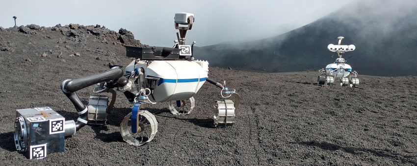
SCHUSTER et al.: THE ARCHES SPACE-ANALOGUE DEMONSTRATION MISSION                                                                                        3

      System       System Features                                                       Capabilities
  ARDEA [6], [7]
                     •   Flying system with high maneuverability                           •   Fast autonomous scouting for exploration and mapping
                     •   Ultra wide-angle stereo (240◦ vertical, 80◦ horizontal FoV)       •   Identification of points of interest via semantic analyses
                     •   Intel i7 dualcore at 3.0 GHz (main computer), BeagleBone          •   Act as mobile radio communication relay
                         ARM (control), Spartan 6LX75 FPGA (dense stereo at 8 Hz)          •   Outdoor flight time of up to 10 min (104 Wh battery)
   LRU1 [5], [9]     •   Individually controlled & powered wheels on actuated bogies       •   Autonomous exploration and mapping in rough terrain
                     •   Pan/tilt camera head with stereo navigation cameras               •   Carrier for ARDEA
                     •   Scientific cameras: infrared camera, narrow-angle camera and      •   Scientific analyses of rocks etc. with spectral and ther-
                         stereo cameras with spectral filter wheels                            mal cameras
                     •   Take-off and landing platform for ARDEA                           •   Autonomous operation time of up to 1.5 h in outdoor
                     •   Intel i7 quadcore at 2.7 GHz (main computer), Intel Atom              space-analogue environment (2 × 208 Wh batteries)
                         (control), Spartan 6LX75 FPGA (dense stereo at 11 Hz)
  LRU2 [5], [16]     •   Individually controlled & powered wheels on actuated bogies       •   Autonomous exploration and mapping in rough terrain
                     •   Pan/tilt camera head with stereo navigation cameras               •   Collection of geological samples (sand or small rocks)
                     •   Manipulator arm with automatic docking interface                  •   Deployment of scientific instruments (e. g., radio anten-
                     •   Carriers for payload boxes (see below) and exchangeable tools         nas or mobile spectrometers)
                         (robotic hand to grasp stones & shovel to sample soil)            •   Deployment of infrastructure (e. g., radio repeaters)
                     •   Intel i7 quadcore at 2.7 GHz (main computer), Intel Atom          •   Autonomous operation time of up to 1.5 h in outdoor
                         (control), Spartan 6LX75 FPGA (dense stereo at 15 Hz)                 space-analogue environment (2 × 208 Wh batteries)
    Lander [9]       •   Solar panels and batteries                                        •   Perform computationally expensive tasks
                     •   Computational power                                               •   Save and aggregate data for downlink to Earth
                     •   Communication link to mission control on Earth                    •   Gather solar power and recharge robots
                     •   Storage for payload boxes with sample containers, scientific      •   Store samples for future analysis
                         instruments, and infrastructure elements                          •   Act as artificial landmark for navigation
  Payload Boxes    Variants of payload box content:                                      Depending on content and placement of box:
     [9], [17]        • Scientific instruments:                                            • Take scientific measurements
                           – Low frequency radio array (LOFAR) antenna elements            • Analyze elemental rock or soil composition
                           – Laser-induced breakdown spectroscopy (LIBS)                   • Carry multiple soil or rock samples
                                                                                           • Localize payload boxes via Radio-CPT
                      • Radio-based positioning system (Radio-CPT) & radio relay
                                                                                           • Extend communication range
                      • Soil or rock sample container
                                                                                           • Provide power and communication to instruments
                   Each box has a common docking adapter to be grasped by LRU2.            • Act as artificial landmark for navigation

  TABLE I: Members of our heterogeneous robotic team with their complementary implemented and planned capabilities.

LOFAR for a carrier frequency between 20 MHz and 30 MHz
in an area of about 100 m×100 m. A LOFAR antenna element
in the ARCHES analogue mission consists of a sensor payload
box comprising a novel radio communication, positioning, and
time-synchronization (Radio-CPT) system, a power supply and
house-keeping unit, and a software-defined radio with a self-
unfolding short dipole to receive radio signals from space.
   In the LOFAR mission sketched out in Fig. 2, a team
of scientists and operators select favorable array geometries
for radio-astronomy observations. This selection process is
assisted through a performance prediction software, taking
into account resulting array directivity, wireless communica-
tion range, and Radio-CPT based self-localization accuracy.                Fig. 3: ARCHES scenario with collaborative geological explo-
ARDEA then explores the area where sensor boxes shall                      ration and sampling (numbers indicate sequence of tasks).
be placed ( ). In the meantime, LRU2 places Radio-CPT
anchor boxes next to the lander, which are used for a precise
localization of the antenna elements later on. A minimum                   important prerequisite to operate a distributed array. Short
of three anchors is needed to align the local LOFAR and                    dipole antennas in each sensor box are released, the LOFAR is
global lander coordinate frames. Afterwards, LRU2 picks four               in-field calibrated, and the LOFAR signal reception starts ( ).
LOFAR sensor boxes from the lander and places them in the                  Pre-processed received signals are sent back to mission control
afore defined array geometry, while LRU1 uses its cameras to               for further processing and visualization by scientists, e. g., to
measure in the Radio-CPT anchors locations w. r. t. the lander             identify S-type or L-type Jovian radio bursts [20]. In addition,
( ). At least three LOFAR boxes are required to determine                  scientists can select different modes of operation in post-
the low frequency signal’s direction of arrival (azimuth and               processing, i. e., monitoring solar radio-bursts during daytime,
elevation), while a larger number of boxes will allow an                   estimating the angle of arrival of a strong source, or digitally
increased array aperture. For this, our system can be scaled               steering the LOFAR beam in a specific direction. After dis-
up in a straightforward fashion. After placement, our Radio-               ruptive events such as a dust storm on Mars, ARDEA can be
CPT system automatically locates all boxes precisely: an                   sent to visually inspect the antenna array for damages ( ).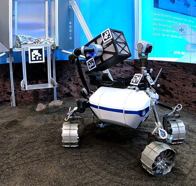
4 IEEE ROBOTICS AND AUTOMATION LETTERS. PREPRINT VERSION. ACCEPTED JUNE, 2020
Fig. 5: Screenshot of the 3D GUI and status icons (per robot)
of the ROSMC high-level mission control framework.
mission planning, (3) mission refinement, (4) synchronization
to the robots, and (5) mission execution and monitoring.
To generate an initial mission plan, we use an automated
Fig. 4: Overview of our high-level mission control flow. planning algorithm that can handle cooperative tasks and
precedence constraints relevant in both ARCHES missions.
First, a greedy initialization similar to [21] provides a feasible
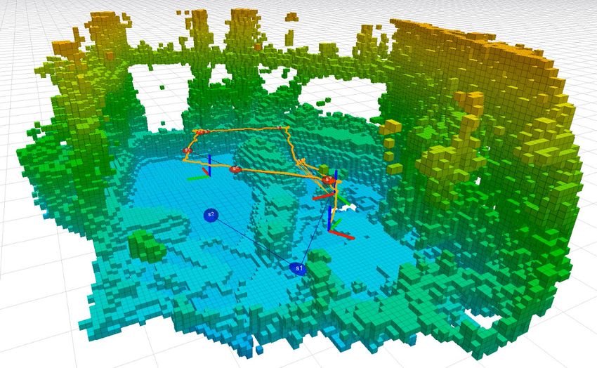
B. Geological Exploration and Sampling
initial solution. It is then refined via an optimization heuristic
The goal of the upcoming ARCHES geological sampling based on the idea of a relocation neighborhood known in
demonstration mission on Mt. Etna in 2021 is the creation of vehicle routing [22], which we adapted to multi-robot task-
an accurate map of a target region, the spectral analysis of allocation. For details and evaluations of the coordination
rocks, as well as the collection of sand and rock samples. For algorithm, we refer to [23]. The tasks to be scheduled for the
this, we will leverage the complementary capabilities of our individual robots belong to predefined types. For ARCHES,
heterogeneous team of (semi-)autonomous robots. In Fig. 3, the main ones include “take image” (ARDEA, LRU1, LRU2),
we give an overview of the mission scenario. It involves the “take science image” (LRU1), “take sample” (LRU2), and
deployment of our robot systems and infrastructure elements “take sample scientific mode” (LRU2 takes sample based on
listed in Table I. A landing spot had been selected by a team spectral images by LRU1). In addition, there are auxiliary task
of scientists and mission operators based on prior knowledge types for LRU2: “install radio range extender”, “pick payload
from satellite imagery. It is located near three geologically box”, and “place payload box”. Each task is related to a POI
interesting locations marked as points of interest (POIs) in for its execution. While main tasks are specified by the scien-
Fig. 3. As a first step after landing, our rover LRU1 ( ) tist, auxiliary tasks are added automatically whenever needed.
is sent out to explore the closest POI in a nearby crater. It Each auxiliary task adds a precedence constraint as, e. g., a
drives towards the target area while autonomously avoiding sample container needs to be fetched prior to collecting a
obstacles on its way. ARDEA, our drone, is carried by the sample. The planner calculates an individual schedule for each
rover on its transport and take-off platform. Upon reaching robot, optimizing the overall mission time, driven distances,
the target area, the 3D map created by LRU1 shows that the and energy consumption.
crater slope is too steep for the rover to enter. Therefore, To enable intuitive task definition, mission refinement, and
mission control decides to launch the drone ARDEA ( ) to robust, distributed mission execution and monitoring, we intro-
further explore and map the crater from inside. At the same duce our novel ROSMC (ROS Mission Control) framework.
time, LRU2 ( ) is sent out to place a payload box with a It provides two graphical user interfaces (GUIs): a 3D GUI
communication relay in between the lander and the two other, visualizing the global map, the agents’ poses, status, POIs, and
farther-away POIs to ensure radio coverage. In a second step, ROIs (see Fig. 5) as well as a command GUI to define task
LRU1 ( ) moves towards the next nearby, easier accessible, sequences and parameterization. Mission control can adapt
POI and uses its spectral cameras to identify stones for further the pre-planned schedule of each robot: the 3D GUI allows
inspection. Thus, mission control sends LRU2 ( ) to deploy its to add tasks via a tree menu and to modify their POIs or
LIBS instrument for laser spectroscopy and to collect the most ROIs, the command GUI to rearrange their order. The entire
promising rock sample, which it then returns to the lander ( ). mission consists of a synchronized and a non-synchronized
In the meantime, ARDEA ( ) inspects and maps the final POI part, both being stored and tracked on a central mission server
with its ultra-wide angle cameras to estimate the scientific gain with low computational requirements. The former part, which
of close-up inspection with the other robots. It then returns to is read-only in the GUIs, is sent to each robot so that they
the lander ( ) for recharging. can execute the mission on board. The mission progress is
stored locally and sent to the server when communication
V. H IGH -L EVEL M ISSION C ONTROL becomes available. In case of an error during runtime, the
For high-level mission control, we developed a framework synchronized part can be deleted from the robot, adapted,
for the efficient operation of multiple heterogeneous robots and then re-synchronized. Powerful execution modalities based
without requiring advanced robotics skills. The overall flow, on hierarchical state machines modeled in our open source
see Fig. 4, consists of (1) task definition, (2) automated initial framework RAFCON [24] allow to pause and resume the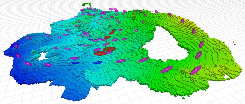
SCHUSTER et al.: THE ARCHES SPACE-ANALOGUE DEMONSTRATION MISSION 5
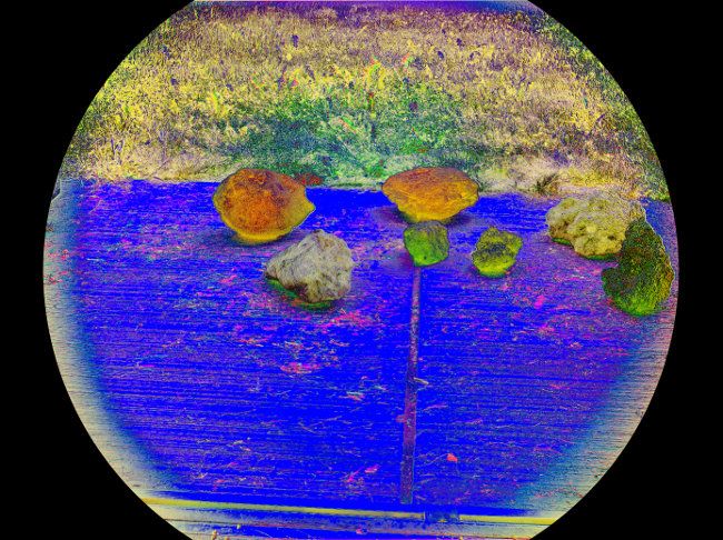
(a) ScienceCam sensor head (b) RGB image and science product
with its seven cameras of volcanic rocks
Fig. 6: ScienceCam (a) and science product (b) visualized
− Blue Geo6 − Geo1
as RGB = (Geo4, Geo1Geo1 + Blue , Geo6 + Geo1 ). Whereas the lava
bomb and black scoria basalt look similar in the RGB image,
they can be clearly distinguished in the science product.
behavior of each robot, to modify it, and to exchange the Fig. 7: LIBS spectra of a felsic rock and a dark fine-grained
robots’ entire command sequences during their mission. Task soil obtained with the ARCHES LIBS module for the LRU.
synchronization is achieved peer-to-peer without the server: The continuous emission was removed by a polynomial fit.
robots communicate task ids with each other to coordinate
inter-robot task dependencies. We are in preparation of a can be calculated to distinguish different types of rocks. In
separate publication with details on ROSMC and intend to Fig. 6(b), we give an example based on a solely geometrically
release it as open source in the future. calibrated camera with the Blue (460 nm), Geo1 (440 nm),
During mission execution, control can be switched to man- Geo4 (560 nm), and Geo6 (660 nm) filters. For examination,
ual mode in case teleoperation is feasible and required. We we visualized the resulting channels as RGB: rocks that cannot
employ a robotic arm as a generic haptic human-machine be discriminated in the visible spectrum clearly stand out.
interface (HMI) to teleoperate different types of robots in a
heterogeneous team. Its six degrees of freedom (DoF) allow
B. Laser-Induced Breakdown Spectroscopy (LIBS)
for a direct mapping of the HMI states to the positions and
orientations of the teleoperated robots, enabling an intuitive To perform elemental analysis of rocks and soil in its
operation both in large-scale and precision tasks. Each DoF environment, LRU2 can equip itself with a laser-induced
is actuated, which permits a continuous shift of the option- breakdown spectroscopy (LIBS) instrument that is housed in
based levels of automation [25], covering the whole range from a payload box. LIBS can be used in close-up or remote con-
manual control via shared autonomy to full autonomy. Thus, figurations and gains more and more relevance for planetary
operators can be supported with a cooperating automation in-situ exploration. Our LIBS module is connected to the
to reduce their workload during teleoperation. As the haptic rover’s arm and built from commercial components (laser,
feedback is computed on the local HMI controller, the overall spectrometer, micro-controller). It weighs about 1 kg and scans
system is robust to communication delays. a small surface in close distance from the modular box with
These features render our mission control software more sampling rates of up to 30 Hz. A Nd:YAG laser with 8 mJ and
powerful than many approaches of related work, e. g., 6 ns pulses at 1064 nm is used to create the micro plasma. The
IMPACT [26], which does not allow a parameterization of spectrometer covers a range of wavelengths of 550−770 nm, in
reactive behavior, and M2PEM [27], which neither supports which major rock-forming elements such as silicon, calcium,
heterogeneous teams nor allows to switch to manual control. sodium, and potassium can be detected, see Fig. 7. Also
minor and trace elements such as hydrogen and lithium can
VI. S PECTRAL A NALYSIS OF ROCK S AMPLES be observed, as well as the emission of nitrogen, which results
from a breakdown of the ambient atmosphere.
The geological exploration of planetary surfaces aims at
understanding the history of our solar system and supports VII. D ISTRIBUTED C OLLABORATIVE M ULTI -ROBOT
the search for signs of life, resources, and habitable areas. 6D SLAM IN M OON -A NALOGUE E NVIRONMENT
Multi-robot 6D Simultaneous Localization and Mapping
A. ScienceCam (SLAM) allows robots to localize themselves w. r. t. each other
LRU1 is equipped with a scientific camera, shown in Fig. 6 and build a shared dense 3D model of their environment for au-
and introduced in [9] as ScienceCam. It has a concept similar tonomous exploration, mission planning, and the coordination
to the PanCam of the ExoMars rover [28]. In addition to three of joint actions. We employ our online and on-board collabo-
navigation cameras, it houses wide-angle stereo (WAC, Manta rative multi-robot SLAM framework [29], [30] to map rough-
G-145B NIR), a thermal (Xenics Serval-640), and a narrow- terrain environments in a distributed fashion: high-frequency
angle camera (Manta G-505C). The two WACs have spec- and high-bandwidth sensor data is locally aggregated in real-
tral filter wheels, each containing three color filters (100 nm time on each robot and then exchanged via so-called submaps
bandwidth) and six narrow band (10 nm bandwidth) geology between the systems. In contrast to other recent distributed
filters (Geo1 − Geo12) across ranges of 440 − 660 nm and SLAM approaches such as [31], [32], ours does not rely on a
720 − 1000 nm. By combining several bands, science products central server to delegate optimization and map managemnet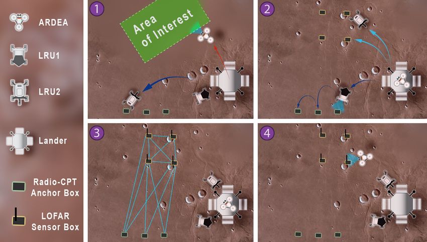
6                                                         IEEE ROBOTICS AND AUTOMATION LETTERS. PREPRINT VERSION. ACCEPTED JUNE, 2020

(a) LRU1 narrow-angle and ARDEA ul- (b) Height-colored probabilistic voxel-grid map by (c) Detail of (b): robot detections (orange
tra wide-angle camera & depth data  three agents (LRU1, LRU2, ARDEA sensor stack) edges) between ARDEA and both rovers
Fig. 8: Distributed multi-robot 6D SLAM in challenging conditions (harsh shadows, overexposures due to bright sunlight); data
acquired in three-agent experiment at Moon-analogue site on Mt. Etna (10 cm map resolution, 1 m2 background grid cells);
ellipsoids show submap origins and positional uncertainty for LRU1 (blue), LRU2 (red), ARDEA sensor stack (pink).

         Multi-robot SLAM graph    LRU1   LRU2    ARDEA
          Number of robot poses     48     28        42
            Number of submaps       7      10        78
      Number of robot detections    0      17       42

TABLE II: Statistics for collaborative mapping exp. of Fig. 8.

tasks. Instead, every agent maintains a full SLAM graph for          (a) Mars-like scenario with sand      (b) Probabilistic height-colored
incremental online global optimization, exchanging constraints       and large artificial rocks (50 m2 )   voxel-map (10 cm resolution)
(submap matches and robot detections) and compacted submap           Fig. 9: Multi-robot SLAM with LRU1 and ARDEA at
data (3D voxel-grids and pointclouds) with no need for dupli-        IAC 2018; all computation online and on board both robots.
cate transmissions. This allows distributing the computational
workload and keeping communication bandwidth requirements            tion accuracy depends on the clock accuracy, carrier frequency,
low. We refer to [29], [30] for further details on our SLAM          transmit power, bandwidth, and the environment, which can
framework, including more than 30 real-world experiments             promote multipath propagation [35]. In the ARCHES scenario,
with five different robot platforms and evaluations regarding        multipath effects are, however, not significant. We developed
accuracy, runtime, and ressource requirements.                       a distributed particle filter algorithm for radio localization
   Going beyond our previous two-agent SLAM experiments              [36], obtaining near-optimal performance with a complexity
[29], [30], [10], we present first three-agent SLAM results on       significantly lower than other state-of-the-art algorithms like
data acquired by a heterogeneous team of two LRU rovers and          [37]. In order to deal with the instability of low-cost oscilla-
the sensor stack of our drone ARDEA at the Moon-analogue             tors, we implemented a distributed Kalman filter to track their
site [9]. In Fig. 8(a), we highlight challenges faced by the         characteristics using short TDMA frames (below 100 ms) [34].
robots observing the world with their stereo cameras. In Fig. 8,        We studied the joint estimation of LOFAR box location and
we show the resulting dense multi-robot 3D map on a slope            LOFAR signal direction of arrival (DoA) in [38]. Our LOFAR
of Mt. Etna. Both rovers autonomously explored a given area          setup targets signal reception at 20 MHz carrier frequency, i. e.,
by maximizing their expected information-gain [33]. In the           a wavelength of 15 m. Accurate beam steering in azimuth and
meantime, we carried the sensor stack of ARDEA between               elevation requires an array localization accuracy of at least
them, simulating a flight that explores further areas, see the       one order of magnitude higher than the carrier wavelength,
outer parts of the map in Fig. 8(b). Visual markers on both          which is 1.5 m for our system. We showed in simulation
rovers allowed close-range detection by each other and by            and multiple outdoor experiments [36], [34] that sub-meter
ARDEA in order create inter-robot loop closures, shown as            accuracy can be achieved in an environment similar to the
edges in the SLAM graph in Fig. 8(c). The robots thus acted          space-analogue mission, thereby verifying the feasibility of
as moving landmarks for each other, enabling a joint pose            our approach. We plan to further reduce the impact of the
and map optimization. The resulting multi-robot graph has a          LOFAR box location uncertainty on LOFAR DoA estimation
total of only 213 nodes and 270 factors, see Table II, and thus      via online phase calibration [39].
allows for fast optimization.
                                                                      IX. I NTEGRATION T ESTS IN M ARS -L IKE E NVIRONMENT
    VIII. R ADIO - BASED L OCALIZATION (R ADIO -CPT)                    As a major milestone, we integrated several components
   The LOFAR mission (Sec. IV-A) depends on precisely lo-            for three different multi-system live demonstrations at IAC
cating the LOFAR boxes, which will be achieved by our radio          2018 in a Mars-like sandbox of 50 m2 , shown in Fig. 9. It
communication, positioning, and time-synchronization (Radio-         features a lander mockup and artificial rocks as navigational
CPT) system. The boxes are connected by bi-directional radio         and visual obstacles. All software required for autonomous
frequency (RF) links with a carrier frequency of fc = 5.8 GHz,       robot behavior ran online and on board the three robots.
a bandwidth of Bc = 25 MHz, and a self-organized time divi-             First, we demonstrated our distributed collaborative 6D
sion multiple access (SO-TDMA) protocol [34]. The localiza-          SLAM with a heterogeneous team of our rover LRU1 and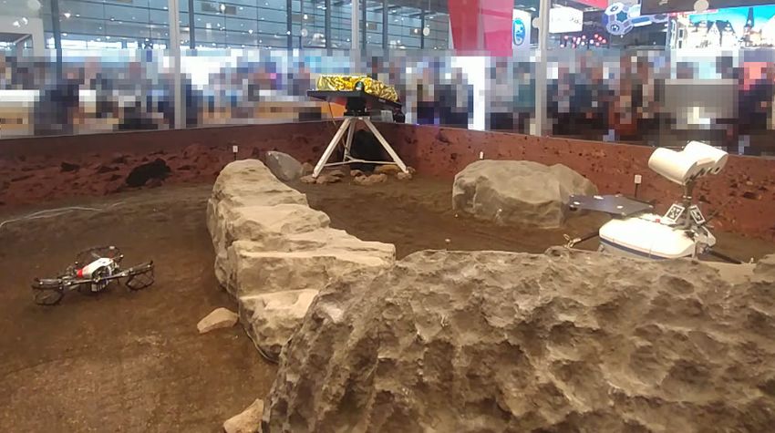
SCHUSTER et al.: THE ARCHES SPACE-ANALOGUE DEMONSTRATION MISSION                                                                                     7

                                                                           For the ARCHES demonstration on Mt. Etna in 2021, we
                                                                        will bring together and extend the systems and capabilities
                                                                        shown at IAC 2018. As we experienced in the ROBEX cam-
                                                                        paigns [9], the additional challenges of full system integration,
                                                                        environment conditions (terrain, light, wind, local gravity, air
                                                                        density, etc. different to the lab), and logistics are not to be
Fig. 10: Sequence of our IAC 2018 autonomous sample-return              underestimated. Furthermore, we started to adapt individual
demonstration: (1) pick up container at lander, (2) extract             modules for the Martian Moons eXploration mission (MMX)
sample, (3) reclaim container and return it to lander.                  to navigate a rover on Phobos in 2026 [42].

drone ARDEA in more than 35 successful live runs. On-                                         ACKNOWLEDGMENT
board and online, both robots locally created partial 3D maps,
                                                                          We thank the Mobile Robots Group at DLR-RMC and the
exchanged, optimized, and merged them to a collaboratively
                                                                        ARCHES & ROBEX teams for support with the systems and
built joint map of the environment. To connect the maps via
                                                                        experiments, and the reviewers for their insightful suggestions.
loop closure constraints, ARDEA detected visual markers on
LRU1 during its flight. We show the final 3D map in Fig. 9
and refer to [30], [7] for further details on this demonstration.                                     R EFERENCES
   Second, in further 35 live runs, we demonstrated the robust           [1] ISECG, “Global Exploration Roadmap,” International Space Exploration
integration of our on-board navigation, task execution, and                  Coordination Group, Tech. Rep., 2018.
                                                                         [2] Y. Gao and S. Chien, “Review on space robotics: Toward top-level
manipulation required for a fully autonomous sample-return                   science through space exploration,” Science Robotics, vol. 2, 2017.
task, as shown in Fig. 10: LRU2 retrieved a sample container,            [3] F. Cordes, et al., “LUNARES: lunar crater exploration with heteroge-
transported it to a target location, placed it on the ground,                neous multi robot systems,” Intelligent Service Robotics, vol. 4, 2011.
                                                                         [4] M. Eich, et al., “Towards Coordinated Multi-Robot Missions for Lunar
grasped a shovel, scooped a soil sample into the payload box,                Sample Collection in Unknown Environment,” J. of Field Robotics,
and returned it to the lander. For details on the method and                 vol. 31, 2014.
earlier experiments on Mt. Etna, we refer to [16].                       [5] M. J. Schuster, et al., “Towards Autonomous Planetary Exploration:
                                                                             The Lightweight Rover Unit (LRU), its Success in the SpaceBotCamp
   Third, we integrated our Radio-CPT system in a robotic                    Challenge, and Beyond,” J. of Intelligent & Robotic Systems, 2017.
mission scenario and demonstrated real-time radio-localization           [6] M. G. Müller, et al., “Robust Visual-Inertial State Estimation with
of LRU2 carrying a Radio-CPT payload box in more than 20                     Multiple Odometries and Efficient Mapping on an MAV with Ultra-
                                                                             Wide FOV Stereo Vision,” in IROS, 2018.
live runs (> 30 min each). The high-rate real-time physical              [7] P. Lutz, et al., “ARDEA - An MAV with skills for future planetary
layer and MAC-layer processing ran in a distributed fashion                  missions,” J. of Field Robotics, 2019.
in seven sensor boxes, and an off-board particle filter provided         [8] A. Wedler, et al., “From single autonomous robots toward cooperative
                                                                             robotic interactions for future planetary exploration missions,” in Inter-
real-time 2D position estimates.                                             national Astronautical Congress (IAC), 2018.
                                                                         [9] ——, “First Results of the ROBEX Analogue Mission Campaign:
            X. C ONCLUSION AND F UTURE W ORK                                 Robotic Deployment of Seismic Networks for Future Lunar Missions,”
                                                                             in International Astronautical Congress (IAC), 2017.
   We summarize our methods to tackle the technical core                [10] M. J. Schuster, et al., “Towards Heterogeneous Robotic Teams for
challenges of the two ARCHES missions in Table III and give                  Collaborative Scientific Sampling in Lunar and Planetary Environments,”
an evaluation regarding their maturity and open challenges. All              in Workshop on Informed Scientific Sampling in Large-scale Outdoor
                                                                             Environments at IROS, 2019.
of our robots are equipped with space-suitable sensor setups
                                                                        [11] L. Graham, et al., “Moon and Mars Analog Mission Activities for Mauna
for visual-inertial navigation in GNSS-denied environments. A                Kea 2012,” in IEEE AeroConf, 2013.
fully decentralized and in large parts distributed computation          [12] É. Dupuis, et al., “Results from the CSA’s 2015 Mars analogue mission
allows an efficient utilization of limited resources and ensures             in the desert of Utah,” in i-SAIRAS, 2016.
                                                                        [13] R. Sonsalla, et al., “Field testing of a cooperative multi-robot sample
robustness to failures of individual agents. All modules run on-             return mission in mars analogue environment,” in ASTRA, 2017.
board and online, i. e., at a rate sufficient for reactive behaviors,   [14] D. St-Onge, et al., “Planetary Exploration with Robot Teams: Imple-
and exchange locally pre-processed data for low-bandwidth                    menting Higher Autonomy With Swarm Intelligence,” IEEE Robot.
                                                                             Automat. Mag., 2019.
communication. This allows full on-board autonomy, which is             [15] A. Husain, et al., “Mapping Planetary Caves with an Autonomous,
crucial in the light of unreliable and delayed communication                 Heterogeneous Robot Team,” in IEEE AeroConf, 2013.
links. We designed our system to scale for heterogeneous                [16] P. Lehner, et al., “Mobile manipulation for planetary exploration,” in
                                                                             IEEE AeroConf, 2018.
teams of n < 10 agents, thus swarms of hundreds of                      [17] G. Tsakyridis, et al., “Power system analysis and optimization of a
robots envisioned for the distant future will introduce further              modular experiment carrier during an analog lunar demo mission on
challenges, in particular w. r. t. data exchange. Our modular                a volcanic environment,” Acta Astronautica, vol. 155, 2019.
                                                                        [18] B. Balaram, et al., “Mars Helicopter Technology Demonstrator,” 2018.
approach allows an easy adaption of core components to                  [19] C. L. Carilli, et al., “Low frequency radio astronomy from the moon:
different robots and settings. Adding new types of sensors                   Cosmic reionization and more,” Cambridge University Press, 2007.
or robots, for example, does not require any changes to the             [20] P. Zarka, “Auroral radio emissions at the outer planets: Observations
                                                                             and theories,” Journal of Geophysical Research: Planets, 1998.
other agents in a team as our multi-robot 6D SLAM connects              [21] Y. Zhang and L. E. Parker, “Multi-robot task scheduling,” in ICRA, 2013.
them on the level of poses and aggregated (sub)map data.                [22] M. W. P. Savelsbergh, “The Vehicle Routing Problem with Time
Furthermore, our framework RAFCON [24] (task execution)                      Windows: Minimizing Route Duration,” ORSA J. on Computing, 1992.
                                                                        [23] E. Bischoff, et al., “Multi-Robot Task Allocation and Scheduling
is available as open source and ROSMC (mission control)                      Considering Cooperative Tasks and Precedence Constraints,” 2020,
planned to be in the future.                                                 (submitted, preprint on arXiv).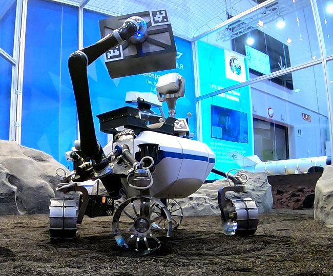
8 IEEE ROBOTICS AND AUTOMATION LETTERS. PREPRINT VERSION. ACCEPTED JUNE, 2020
Technical Core Components & Validation Experiments &
Methods Results & Open Challenges
Challenges Modules Status Demonstrations
High-Level GUIs (in RViz + User study: 9 people, Concepts for sub-groups and n > 3
ROSMC (Sec. V) Simulation
Mission Control RQt) & data server three-robot simulations robots; will require UI adaptions
Multi-robot Greedy init. & local Evaluated on 600 instances Reliable generation of feasible opti-
Automated Task
scheduling improvement Simulation (up to 3 robots, 15 tasks mized plans; future work: integration
Planning
(Sec. V) heuristic [23] with 9 coop. tasks) [23] with mission control
Hierarchical Space-like & Sim. & lab, SpaceBot- Statemachines with 8 hierarchy lev-
Autonomous RAFCON
statemachines with analogue Camp 2015 [5], ROBEX els and > 700 states per robot; fu-
Task Execution (Sec. V, [24])
concurrent execution environments 2017 [16], IAC 2018 ture work: multi-robot world model
Shared Teleop. of LRU camera Results: 6DoF HMI with generic
Haptic 6DoF Haptic shared Simulation &
Autonomy in head, simulated drone, and haptics & supporting automations;
HMI (Sec. V) control [25] laboratory
Teleoperation 3DoF robotic arm pending: user study on haptic HMI
Fast Scouting of ARDEA On-board robust Space-like & Laboratory [6], IAC 2018 Successful takeoff from rover; land-
Points of wide-angle vision dense stereo analogue [7], Autonomous waypoint ing on LRU challenging due to its
Interest system (Sec.IX) vision [6], [7] environments flight on Mt. Etna 2019 camera mast (work in progress)
6D Multi- Dense submaps, Sim. & lab., SpaceBot- Evaluated with two (on-board) &
Dense 3D Space-like &
Robot SLAM real-time filter + inc. Camp 2015, ROBEX 2017, three (on datasets) agents; Open
Multi-Robot analogue
Framework graph optimization IAC 2018 (n > 35 exp.) challenges: long-range mapping &
Mapping environments
(Sec. VII & IX) [29], [30] [5], [29], [30], [7] multi-session relocalization [40]
Waypoint Obstacle Stereo-adaptive Sim. & lab, SpaceBotCamp Validated on LRU rovers; ARDEA:
Space-like &
Navigation & mapping & terrain classification 2015 (LRU), ROBEX 2016 waypoint navigation & terrain fol-
analogue
Obstacle 2D path planning [30] & adapted ROS & 2017 (LRUs), IAC 2018 lowing [41]; future work: full 3D
environments
Avoidance (Sec. VII & IX) nav. stack [5], [30], [7] path planning for ARDEA
Frontier Information gain- Space-like & Sim. (40 exp.), lab, outdoor Tested single- and multi-robot [30]
Autonomous
exploration based expl. & active analogue & ROBEX 2017 (n > 30 (rovers); future work: full 3D expl.
Exploration
(Sec. VII) loop closing [33] environments real exp.) [33], [5], [30] for drone & multi-criteria decisions
Impedance control, Autonomous deployment & pickup
Compliant Simulation & laboratory,
Payload sampling-based Space-like & of payload; challenges: high uncer-
control, motion SpaceBot-Camp 2015 [5],
Transport & planning, analogue tainties due to object detection and
planning, world ROBEX 2017 [16],
Manipulation synchronized graph environments elasticity in the rover; future work:
model (Sec. IX) IAC 2018 (n > 35 exp.)
database [16] compliant whole-body control
LOFAR Payload Distributed Prelim. experiments: Current & future work: integration
LOFAR Laboratory
Boxes RF-sampling & single-box RF reception in payload boxes, proof of concept
Measurement setup
(Sec. IV-A) beam steering on rooftop experiments with multiple boxes
Space-like & Grass field 2015 [36], Achieved sub-meter accuracy in
LOFAR Box Radio-CPT Distributed
analogue gravel pit 2018 [34], most experiments; challenges: mul-
Localization (Sec. VIII & IX) particle filter [36]
environments IAC 2018, Mt. Etna 2019 tipath propagation & instable clocks
Panoramic & Anomaly detection Lab, space- Prelim. tests with volcanic Radiometric & spectral calibration
ScienceCam
Multi-Spectral via combination of analogue rocks [10]; panorama at difficult → differentiation but no
(Sec. VI-A)
Imaging spectral images environment space-analogue site classification of minerals possible
Elemental Rock LIBS Optical emission Lab tests of Eight reference spectra of Validated on rocks & sand; integra-
& Soil Analysis (Sec. VI-B) spectroscopy instrument geological samples tion with LRU payload box pending
TABLE III: Summary of our approaches to the core challenges of the ARCHES missions and evaluation of their maturity.
[24] S. G. Brunner, et al., “RAFCON: A Graphical Tool for Engineering Robotics and Automation Letters (RA-L), 2018.
Complex, Robotic Tasks,” in IROS, 2016. [33] H. Lehner, et al., “Exploration with Active Loop Closing: A Trade-off
[25] C. A. Braun, et al., “A Continuous and Quantitative Metric for the Levels between Exploration Efficiency and Map Quality,” in IROS, 2017.
of Automation,” in IFAC Symposium on Analysis Design and Evaluation [34] E. Staudinger, et al., “Swarm navigation and exploration for plane-
of Human Machine Systems, 2019. tary surface missions: Experimental results,” in International Planetary
[26] M. Draper, et al., “Intelligent Multi-Unmanned Vehicle Planner with Probe Workshop, 2019.
Adaptive Collaborative/Control Technologies (Impact),” in International [35] D. Dardari, et al., “Ranging With Ultrawide Bandwidth Signals in
Symposium on Aviation Psychology, 2017. Multipath Environments,” Proc. IEEE, vol. 97, 2009.
[27] J.-P. de la Croix, et al., “Mission modeling, planning, and execution [36] S. Zhang, et al., “Distributed direct localization suitable for dense
module for teams of unmanned vehicles,” in Unmanned Systems Tech- networks,” IEEE Trans. Aerosp. Electron. Syst., 2019.
nology XIX. International Society for Optics and Photonics, 2017. [37] H. Wymeersch, et al., “Cooperative Localization in Wireless Networks,”
[28] E. J. Allender, et al., “The ExoMars Spectral Tool (ExoSpec): an image Proc. IEEE, vol. 97, 2009.
analysis tool for ExoMars 2020 PanCam imagery,” in SPIE Image and [38] S. Zhang, et al., “Self-Aware Swarm Navigation in Autonomous Explo-
Signal Processing for Remote Sensing, 2018. ration Missions,” (accepted).
[29] M. J. Schuster, et al., “Distributed stereo vision-based 6d localization [39] M. Viberg and A. L. Swindlehurst, “A Bayesian approach to auto-
and mapping for multi-robot teams,” J. of Field Robotics, 2018. calibration for parametric array signal processing,” IEEE Transactions
[30] M. J. Schuster, “Collaborative Localization and Mapping for Au- on Signal Processing, vol. 42, 1994.
tonomous Planetary Exploration: Distributed Stereo Vision-Based 6D [40] R. Giubilato, et al., “Relocalization With Submaps: Multi-Session Map-
SLAM in GNSS-Denied Environments,” Ph.D. dissertation, University ping for Planetary Rovers Equipped With Stereo Cameras,” Robotics
of Bremen, 2019. and Automation Letters (RA-L), vol. 5, 2020.
[31] K. Ebadi, et al., “LAMP: Large-Scale Autonomous Mapping and [41] M. G. Müller, et al., “Efficient Terrain Following for a Micro Aerial
Positioning for Exploration of Perceptually-Degraded Subterranean En- Vehicle with Ultra-Wide Stereo Cameras,” in IEEE AeroConf, 2020.
vironments,” 2020, (preprint on arXiv). [42] J. Bertrand, et al., “Roving on Phobos: Challenges of the MMX Rover
for Space Robotics,” in ASTRA.
[32] M. Karrer, et al., “CVI-SLAM collaborative visual-inertial SLAM,”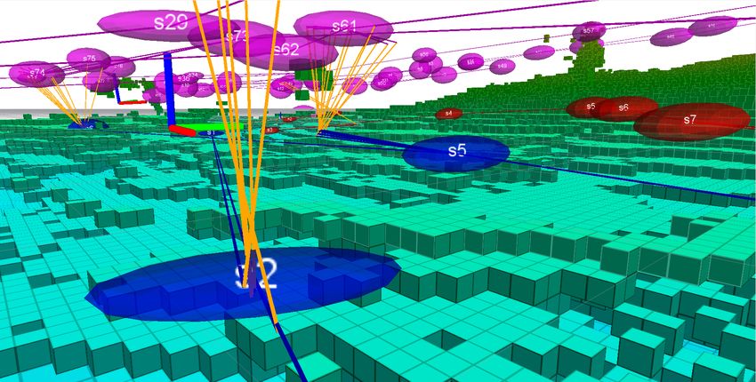
You can also read