THE MARYLAND-NATIONAL CAPITAL PARK AND PLANNING COMMISSION
←
→
Page content transcription
If your browser does not render page correctly, please read the page content below
MONTGOMERY COUNTY PLANNING DEPARTMENT
THE MARYLAND-NATIONAL CAPITAL PARK AND PLANNING COMMISSION
MCPB
Item No.: 5
Date: 04-29-21
Washington Grove Connector – Crabbs Branch Way Extension Facility Planning Study Briefing
Stephen Aldrich, Master Planner, Stephen.Aldrich@montgomeryplanning.org, 301-495-4528
Jason Sartori, Chief, CP&P, Jason.Sartori@montgomeryplanning.org, 301-495-2172
Completed: 04-22-21
Description
The Montgomery Department of Transportation (MCDOT) will be providing a briefing to the Planning
Board on two projects in the Shady Grove/Washington Grove area that are being managed together: 1)
the Washington Grove Connector, a trail connecting Crabbs Branch Way into the Town of Washington
Grove and 2) The Crabbs Branch Way Extension facility planning study for a road connecting Crabbs
Branch Way to Amity Drive. MCDOT has developed four trail alternatives for the Washington Grove
Connector to improve connectivity between the Town of Washington Grove and the Shady Grove
Metrorail Station. The Planning Board is asked to recommend a preferred alternative to MCDOT for the
trail project.
Applicant: Montgomery County Department of Transportation
Shady Grove Sector Plan (2006), Bicycle Master Plan (2018) and Shady Grove Minor Master Plan
Amendment (2021 anticipated)
Staff Recommendation: Approval to Transmit Comments
Summary
The Montgomery County Department of Transportation (MCDOT) is conducting a facility planning study
for two related projects in the Shady Grove/Washington Grove area: 1) the Washington Grove Connector,
a trail connecting Crabbs Branch Way into the town of Washington Grove, and 2) the Crabbs Branch Way
Extension study, which would connect Crabbs Branch Way to Amity Drive.
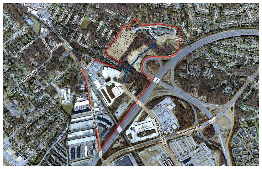
The project location is depicted in Figure 1. The Washington Grove Connector project is being funded
through the Bikeway Program Minor Projects program (P507596), and this project is funded for planning,
design and construction. It is anticipated to be fully constructed in FY24. The Crabbs Branch Way Extension
project is being funded through the Facility Planning-Transportation program (P509337), and this project
is only funded through facility planning during FY20-21. The Crabbs Branch Way Extension project has
been delayed largely to due to COVID-19 issues, the main one being the difficulty in collecting accurate
transportation data during the pandemic. This study will include a detailed transportation analysis of the
transportation effects of this proposed road extension; however, at this briefing, MCDOT will present the
proposed road connection and estimated construction costs.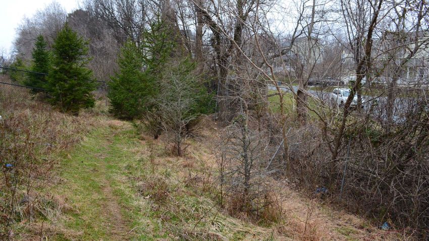
Figure 1: Project Limits and Site Vicinity

Recommendations
    Staff recommends approval to transmit the following comments to the Montgomery County Department
    of Transportation:

       1. Washington Grove Connector Alternative #3 (Brown Street) should be advanced as the preferred
          trail alignment. This trail should be designed to county typical standards, including a trail width of
          ten feet with 2-foot wide unpaved, graded shoulders, and with no obstructions within two feet of
          the trail edge,
                                                          2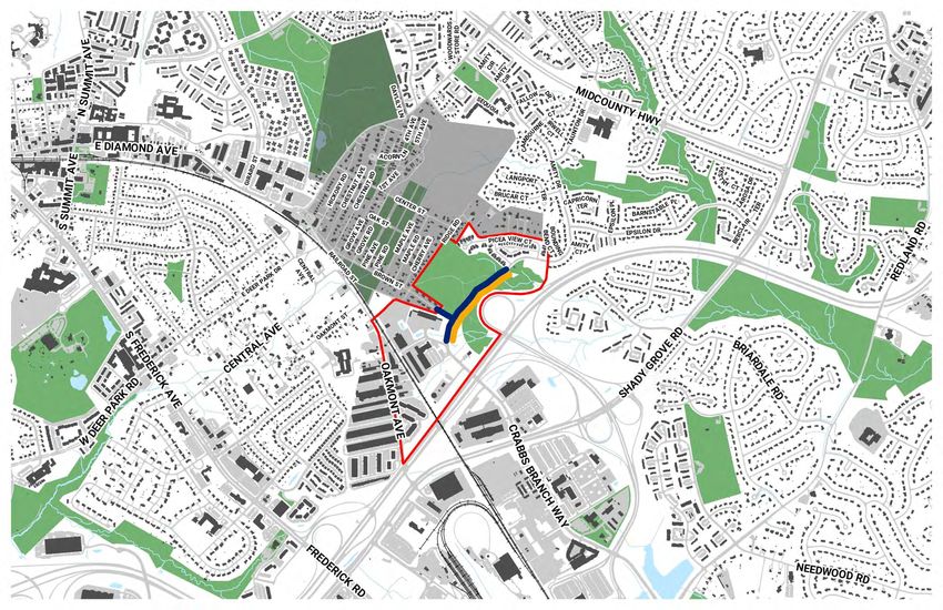
2. Washington Grove Connector Alternative #4 (Picea View Court Connector) should be advanced as
           an additional trail connection, as it has its own merits/independent utility for connecting the
           Amity Drive area with the Town of Washington Grove for pedestrians and cyclists,
        3. The cross section used to design the Crabbs Branch Way Extension should use the Neighborhood
           Connector street type presented in the Complete Streets Design Guidelines,
        4. MCDOT should come back for a second briefing for the Crabbs Branch Way Extension project,
           once significant study and conclusions are reached for this facility planning study,
        5. MCDOT should re-evaluate the need and alignment for the Amity Drive Trail Connector as
           presented in the briefing, as this connections could either be accomplished using the Crabbs
           Branch Way Extension alignment (if this road is constructed) or as a separate trail along generally
           the same alignment (if the road is not constructed). Montgomery Parks has concerns with the
           alignment shown during this briefing and has noted the existence of an unsigned, people’s choice
           trail that would be preferable.
        6. Any trail or roadway alignments pursued are required to proceed through Montgomery Parks
           Concept Review process and Park Construction Permit Review and Approval prior to any
           construction.

Proposed Study
    Project Description
    The Montgomery County Department of Transportation (MCDOT) is conducting a facility planning study
    for two related projects in the Shady Grove/Washington Grove area: 1) the Washington Grove Connector,
    a trail connecting Crabbs Branch Way into the town of Washington Grove, and 2) the Crabbs Branch Way
    Extension study, which would connect Crabbs Branch Way to Amity Drive. For this review, comments have
    been primarily limited to the Washington Grove Connector, as there are limited analysis and findings from
    the Crabbs Branch Way Extension study at this time.

    MCDOT initiated this study in coordination with the Town of Washington Grove in early 2020. The first
    public meeting was held on this project on February 13, 2020. The second public meeting was held one
    year later on February 21, 2021. Meeting materials are provided on MCDOT’s project website located at
    https://www.montgomerycountymd.gov/dot-dte/projects/washgroveconnector/index.html. A copy of
    the presentation materials from the February 21, 2021 public meeting are included with this staff report
    as Attachment A. MCDOT, in addition, hosted an in-person walking tour recently with a few Brown Street
    residents to walk the routes to address resident concerns.

                                                        3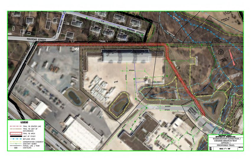
Alternatives Developed
The Washington Grove Connector study developed four trail alternatives, which were presented at the
February 21, 2021 public meeting. Figure 2 presents a map showing the approximate routings of each
alternative. The Alternatives are as follows:

    •   Alternative 1: Railroad Drive/Roberts Oxygen
    •   Alternative 2: Ridge Road
    •   Alternative 3: Brown Street
    •   Alternative 4: Picea View Court

For each alternative, MCDOT prepared a concept layout and developed cost estimates and a summary of
project impacts for each alternative. Concept layouts for the four alternatives are presented in Figures 3
through 6. It is worth noting that Alternatives 1 through 3 share a similar alignment from Crabbs Branch
Way to roughly the property line of Roberts Oxygen.

                           Figure 2: Washington Grove Connector Trail Alternatives

                                                     4
Alternative #1 (Railroad Street/Roberts Oxygen)
Alternative #1 is the longest trail route proposed connecting Crabbs Branch Way to Railroad Street,
however it requires the acquisition of property from the Roberts Oxygen parcel. It also passes through
parkland owned by the Maryland-National Capital Park and Planning Commission (M-NCPPC). This
connection provides a logical direct connection; however, the tie into Railroad Street near the three-leg
intersection of Railroad Street with Ridge Road may be problematic. Traffic volumes on Railroad Street
are higher than the other route ends for the other alternatives. The north-south portion of this alignment
would run directly on a WSSC utility easement, which might pose maintenance of trail issues when work
is done on the WSSC utilities.

           Figure 3: Washington Grove Connector – Alternative 1 (Railroad Avenue/Roberts Oxygen)

                                                    5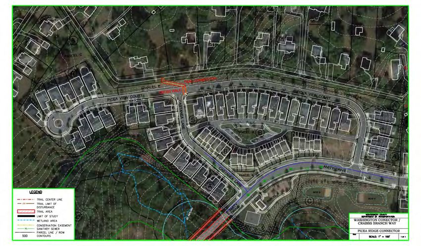
Alternative #2 (Ridge Road)
Alternative #2 is the second longest trail route proposed connecting Crabbs Branch Way to Ridge Road (to
the east of Brown Street). This connection passes through the Town of Washington Grove Meadow
Conservation Park and M-NCPPC property. This alternative would have the greatest impacts to parkland
of the alternatives studied.

                     Figure 4: Washington Grove Connector – Alternative 2 (Ridge Road)

                                                    6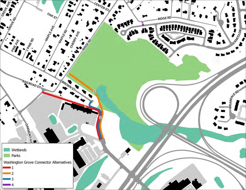
Alternative #3 (Brown Street)
Alternative #3 is the shortest trail route (of the three primary alternatives) proposed connecting Crabbs
Branch Way to Brown Street. This connection passes through M-NCPPC property, similar to Alternative
#1, then travels along a short section of the WSSC easement before terminating at the existing stub end
of Brown Street.

                    Figure 5: Washington Grove Connector – Alternative #3 (Brown Street)

                                                     7
Alternative #4 (Picea View Court)
Alternative #4 (Picea View Court) was identified by public comments received at the first 2020 public
meeting, and this would provide a short connection between Picea View Court and Ridge Road. The intent
is to provide a direct connection between the Town of Washington Grove street network and the Amity
Drive neighborhood.

                  Figure 6: Washington Grove Connector – Alternative #4 (Picea View Court)

Comparison of Impacts – Washington Grove Connector Alternatives
Table 1 presented below provides a summary of anticipated effects/impacts of three of the four
alternatives. During MCDOT’s study, Alternative 4 was not evaluated in the same detail, and from a
Planning Department perspective, seems to have independent utility compared to the three alternatives
presented below. In general, of the three primary alternatives, Alternative #3 (Brown Street) has the
lowest estimated construction cost, the shortest route, and the lowest impact to forested areas. It is also
preferrable to Alternative 1 because the street that it connects to (Brown Street) is lower volume than
the street that Alternative 1 connects to (Railroad Avenue). All Alternatives provide acceptable slopes
along the trails under consideration; however Alternative #1 (Railroad Avenue/ Roberts Oxygen) has the
lowest maximum slope.

                                                     8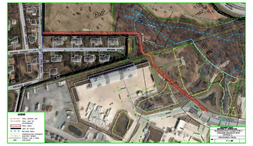
Impact                    Unit              Alt #1             Alt #2             Alt #3
      Surface Area                           SQ FT              21,000             20,000             11,000
      Forest                                 SQ FT              26,000             15,000             12,000
      Stream Crossing                          FT                 15                 15                 15
      Wetlands                               SQ FT              1,000              1,000               1,000
      Flood Plain                            SQ FT              2,000              2,000               2,000
      ROW Acquisition                        SQ FT              16,000                0                2,500
      Permanent Easement                     SQ FT               500                500                 500
      Max Slope                                %                4.0%                4.5%               4.5%
      Cost*                                    $               $575,770          $360,490            $326,430
    * Total construction costs (including 30% contingency) are for comparison and do not include Stormwater
      Management, Utilities, Lighting, Site Prep, etc.
                       Table 1: Washington Grove Connector – Comparison of Impacts by Alternative

Crabbs Branch Way Extension Facility Planning Study
    Limited progress has been made on this facility planning study to-date. But we did want to share the
    conceptual alignment of this planned road connection, an evaluation of effects/impacts and costs. In
    addition, a fifth potential trail connection was developed as part of this road project which would connect
    Amity Drive to the proposed Washington Grove Connector.

    A concept plan was developed by MCDOT for this proposed road connection which is shown in Figure 7.
    This road connection is master planned as a primary residential street. The proposed cross section is
    shown in Figure 8.

    During the study, MCDOT also developed the Amity Drive Trail Connector, as shown in Figure 9. This trail
    was developed for consideration if the Crabbs Branch Way Extension project is not advanced. This trail
    would connect into either of the three primary alternatives studies at the WSSC easement.

                                                           9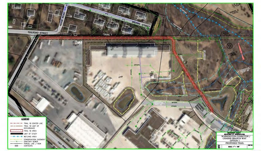
Figure 7: Crabbs Branch Way Extension – Plan View

Figure 8: Crabbs Branch Way Extension – Cross Section

                         10
Figure 9: Crabbs Branch Way Extension – Amity Drive Trail Connector
A summary of project impacts for the Crabbs Branch Way Extension project are provided in Table 2.
Crabbs Branch Amity Drive
Impact Unit Way Extension Connector
Surface Area SQ FT 98,000 20,000
Forest SQ FT 48,000 14,000
Stream Crossing FT 15 0
Wetlands SQ FT 6,000 1,200
Flood Plain SQ FT 7,500 0
ROW Acquisition SQ FT 0 200
Permanent Easement SQ FT 2,000 0
Cost* $2,201,290 $150,800
* Total construction costs (including 30% contingency) are for comparison and do not include Stormwater
Management, Utilities, Lighting, Site Prep, etc.
Table 2: Crabbs Branch Way Extension – Project Impacts
Town of Washington Grove Recommendation
Following the February 21, 2021 Virtual public meeting, the Town of Washington Grove submitted a letter
to MCDOT on March 24, 2021 endorsing Alternative #3 (Brown Street) as the Town’s preferred bikeway
alignment. A copy of this letter is included with this staff report as Attachment B.
11February 2021 Public Meeting Scoring
MCDOT will present more detailed information during their briefing on this project; however, it should be
noted that as part of the public meeting, MCDOT received 55 public comments scoring each Alternative
from 1 to 10. Figure 10 below provides a summary of the average scores of the four alternatives. Overall,
Alternative #3 (Brown Street) scored the highest at 6.59, with Alternative #4 (Picea View Court) coming in
second. Alternative #2 (Ridge Road) received the lowest average score at 4.33.
Figure 10: Washington Grove Connector – Summary of Public Scoring of Alternatives
Master Plan Compliance
The Washington Grove Connector trail being studied is a planned master planned facility. The planned
connection itself is recommended in the Bicycle Master Plan, the 2006 Shady Grove Sector Plan, and the
ongoing 2021 Shady Grove Minor Master Plan Amendment.
The 2006 Shady Grove Sector Plan called for a bicycle connection between the northern terminus of
Crabbs Branch Way and Brown Street. The recent 2021 Minor Master Plan Amendment effort also
contemplated a connection at this location; however, when the Planning Board Draft was released, the
Town of Washington Grove submitted testimony requesting the recommendation for a northern terminus
be generalized to the “Town of Washington Grove.” The rationale for this request was because MCDOT
had initiated its alternatives development work for the proposed connection, but no consensus had been
reached and no alternative had been selected. The Planning Board accepted this request and the edit is
reflected in the approved and adopted Plan Amendment. The Council on April 6, 2021 completed its
review and approval of the Sector Plan Amendment and supports both the roadway connection between
Crabbs Branch Way and Amity Drive. The approval also includes general language regarding the bikeway
connection to the Town of Washington Grove.
12The Crabbs Branch Way Extension between Crabbs Branch Way and Amity Drive is master planned as a
Primary Residential Street in the Master Plan of Highways and Transitways. This planned connection was
included in the 2006 Shady Grove Sector Plan and has been continued as a recommendation in the recent
2021 Minor Master Plan Amendment. A trail facility called the Piedmont Crossing Local Park Trail is also
master planned in the Bicycle Master Plan along the general alignment of this planned road connection.
It should be noted that this planned extension would likely be re-classified as a Neighborhood Connector
using the ongoing Complete Streets Design Guidelines. The typical cross section on this type of street
would call for a sidepath on one side of the street (which would satisfy the Bicycle Master Plan trail
connection), and a sidewalk on the other side of the street. The width of the travel lanes shown in the
concept for this planned extension would also call for 11-foot wide travel lanes.
Parkland Impacts
There are two park units within the project area, the Piedmont Crossing Local Park and the Washington
Grove Meadow Conservation Park. Together the park units support a diverse natural and cultural setting
and offer significant recreational opportunities for the local community. The existing natural surface trail
network that connects both parks provides for active and passive recreation and is highly utilized.
The location’s geologic substrate is serpentine bedrock, which can support some of the most unique plant
communities in the piedmont region. The meadow onsite is considered a Tier 1 meadow (Parks’ highest
quality rating) due to its size and appropriate vegetative structure to support grassland obligate species.
There is only one other such meadow managed on county parkland. As is, the attribute of this site with
the most importance for conservation is its size and interior, which is extremely rare in Montgomery
County. The upland forest area is dominated by mature oaks and still retains native ground layer species.
The forested areas of the site, particularly on the southern and western perimeters of the Piedmont
Crossing Local Park, contain significant hydrologic features that include wetland seeps, a wetland complex,
and a perennial tributary of Mill Creek. An ephemeral tributary of Mill Creek also runs through the forest
along the northern boundary of both parks. The wetland features within the site are fed by both
groundwater input as well as a stormdrain network coming off the existing Crabbs Branch Way and the
adjacent county facility to the west. Despite these stormwater inputs, the wetlands are highly functional
and sustainable trail design techniques would be required in any areas where there is overlap.
The proposed trail alignments may have an effect on known National Register-listed and/or potentially
National Register-eligible cultural resources as well as on Park-owned cultural resources. The historic
Washington Grove Methodist Camp Meeting is a significant 19th century National Register historic district
in Montgomery County and within the state of Maryland. The natural setting of this National Register
district is defined on its southern edge by Washington Grove Conservation Park, which is maintained as a
meadow habitat. Additionally, the area of investigation has the potential to encompass known and/or
high potential prehistoric archaeological sites, including a steatite quarry, a source of stone used by Native
American peoples (18MO621, Washington Grove Steatite Quarry). The area of prehistoric high potential
includes land in both Washington Grove Conservation Park and Piedmont Crossing Local Park. No ground
disturbance should be undertaken in this area without an archaeological treatment plan being in place,
including any staging of construction machines or materials. Any project will need to be evaluated as an
13Undertaking in the context of Section 106 of the 1966 National Historic Preservation Act should any
federal and/or state licenses and/or permits be anticipated for the project.
Of the alternatives advanced by MCDOT, Montgomery Parks supports Alternative #3 (Brown Street) as
the most effective connection from the Washington Grove neighborhood to the end of Crabbs Branch
Way. This option provides an efficient connection while minimizing impacts to natural, cultural, and
historical resources outlined. Alternative #2 is not supported due to the additional impacts this alignment
presents to existing forest, wetland, and meadow habitat, and potential historic/archaeological resources.
The proposed Amity Drive Connector Trail would impact and replace a section of the existing natural
surface trail on Piedmont Crossing Local Park. A trail connection in this location would only be considered
once the evaluation of the Crabbs Branch Way Extension project is complete. If the roadway is extended,
the trail alignment should follow immediately adjacent. A natural surface trail connection from the end of
Amity Drive to the existing Natural Surface Trail loop in the park should be a consideration as part of the
overall trail plan where an unsigned people’s choice trail exists now. Signs, a kiosk at Amity Drive, and a
small bridge would be needed to make this connection official. The master planned road alignment would
have significant impacts to the existing recreational, environmental, and historic resources in the park.
Any trail or roadway alignments pursued are required to proceed through Montgomery Parks Concept
Review process and Park Construction Permit Review and Approval prior to any construction.
Attachment
A. MCDOT Virtual Public Meeting (Feb 21, 2021) Presentation
B. Town of Washington Grove letter (March 24, 2021) to MCDOT
14WASHINGTON GROVE
C ONNECTOR
&
C RABBS B RANCH WAY
EXTENSION
PLANNING BOARD BRIEFING
4-29-2021
1Outline
• Study Overview
• Washington Grove Connector
• Alternatives
• Impacts
• Costs
• Public Input Summary
• Crabbs Branch Way Extension
• Alternatives
• Impacts
• Costs
• Public Input Summary
• Discussion
2Washington Grove Connector Path Crabbs Branch Way to Amity Dr Extension
• Bikeway Program minor (P507596) • Facility Planning Transportation (P509337)
• Funded for Planning, Design & • Funded for Planning only
Project Overview
Construction*
• FY20 - FY24
•
•
Not funded for Design or Construction
FY20 – FY21
3Project Schedule
Nov 2019 Feb 2020 Fall 2020 Spring 2021
Project Kick- Public Workshop #1 Further Analysis Select Preferred
Off Concept
We Are Here
Information
Gathering Public Meeting #2
Winter 2020 Winter 2021
Concept Advance
Development Concept
Summer 2020
2020 2019
4Washington Grove Connector Path • Bikeway Program minor (P507596) • Funded for Planning, Design & Construction • FY20 - FY24 5
Trail Alternatives

6
Washington Grove
   Connector
  Alignment #1 – Railroad Street

                7
8
9
10
11
Alignment #1 - Impacts

Impact                        Unit            Total
Surface Area                         SQ FT            21,000
Forest                               SQ FT            26,000
Stream Crossing                       LF               15
Wetlands                             SQ FT            1,000
Flood Plain                          SQ FT            2,000
ROW Acquisition                      SQ FT            16,000
Permanent Easement                   SQ FT             500

                                                               12
Alignment #1 - Costs
ITEM UNIT QTY COST
Picea View Ct to Ridge Rd – 10 ft Asphalt Trail with 2 ft Grass Shoulders LF 100 $8,000
10 ft Asphalt Trail with 2 ft Grass Shoulders LF 1,350 $108,000
Wooden Retaining Wall LF 130 $16,900
10 ft Stream Crossing/Ped Bridge LS 1 $80,000
10 ft Elevated Boardwalk SF 1,000 $65,000
Row Acquisition LS 16,000 $160,000
Permanent Easement LS 500 $5,000
Subtotal $442,900
Total (+30% Contingency) $575,770
*Costs are for comparison and do not include Stormwater Management, Utilities, Lighting, Site Prep, etc.
13Alignment #1 – Railroad Street
Survey Comments
• Railroad Street is a dangerous road for walking and bicycling
• No bike or ped infrastructure on Railroad Street
• Requires purchase of private land
• Very close to backyards and eliminates buffer between homes and salt
barn
• Least disruptive to neighborhood
• Would feel uncomfortable walking behind salt barns and Robert’s Oxygen
property when dark
• Least use of shared roadways
• Most expensive option
• Does not use Town of Washington Grove roads
14Washington Grove
Connector
Alignment #2 – Ridge Road
1516
17
Alignment #2 - Impacts

Impact                        Unit            Total
Surface Area                         SQ FT            20,000
Forest                               SQ FT            15,000
Stream Crossing                       FT               15
Wetlands                             SQ FT            1,000
Flood Plain                          SQ FT            2,000
ROW Acquisition                      SQ FT              0
Permanent Easement                   SQ FT             500

                                                               18
Alignment #2 - Costs
ITEM UNIT QTY COST
Picea View Ct to Ridge Rd – 10 ft Asphalt Trail with 2 ft Grass Shoulders LF 100 $8,000
10 ft Asphalt Trail with 2 ft Grass Shoulders LF 1,280 $102,400
Wooden Retaining Wall LF 130 $16,900
10 ft Stream Crossing/Ped Bridge LS 1 $80,000
10 ft Elevated Boardwalk SF 1,000 $65,000
Row Acquisition LS - -
Permanent Easement LS 500 $5,000
Subtotal $277,300
Total (+30% Contingency) $360,490
*Costs are for comparison and do not include Stormwater Management, Utilities, Lighting, Site Prep, etc.
19Alignment #2 – Ridge Road
Survey Comments
• Expensive and environmentally impactful to conservation meadow
• Close to backyards
• Requires paving parkland
• Sacrifices natural meadow to avoid Brown St
• Minimizes impact to Brown St residences
20Washington Grove
Connector
Alignment #3 – Brown Street
2122
23
24
25
26
Alignment #3 - Impacts

               Impact                  Unit      Total
Surface Area                          SQ FT      11,000
Forest                                SQ FT      12,000
Stream Crossing                        FT         15
Wetlands                              SQ FT      1,000
Flood Plain                           SQ FT      2,000
ROW Acquisition                       SQ FT      2,500
Permanent Easement                    SQ FT       500
                                                          27
Alignment #3 - Costs
ITEM UNIT QTY COST
Picea View Ct to Ridge Rd – 10 ft Asphalt Trail with 2 ft Grass Shoulders LF 100 $8,000
10 ft Asphalt Trail with 2 ft Grass Shoulders LF 640 $51,200
Wooden Retaining Wall LF 130 $16,900
10 ft Stream Crossing/Ped Bridge LS 1 $80,000
10 ft Elevated Boardwalk SF 1,000 $65,000
Row Acquisition LS 2,500 $25,000
Permanent Easement LS 500 $5,000
Subtotal $251,100
Total (+30% Contingency) $326,430
*Costs are for comparison and do not include Stormwater Management, Utilities, Lighting, Site Prep, etc.
28Brown Street Connection History
• Ward Corporation – Proposal for Annexation – January 10, 1994
• “After meeting with the Town’s planning commission on January 4, 1994;
Ward or his assigns, agree with the following conditions of annexation:
• The Development of the site will provide…a bike path which connects the Brown Street
Extension with the future Amity Way.”
• Resolution 94-04 – Resolution Authorizing the Annexation to the Town
of Washington Grove of Approximately 2.88 Acres of Land Located at
the intersection of Brown Street and Ridge Road
• “Dedication of an outlot to the Town, such outlot to include stormwater
facility required by the County, an area for afforestation, and a bike path
connecting Brown Street and future Amity Drive;”
29Alignment #3 – Brown St
Survey Comments
• Safest option
• Avoids backyards
• Shortest and least costly alternative
• Minimizes impact on trees
• Consistent with 1994 annexation agreement, adopted resolution, and
conveyance of outlot
• Would increase traffic on Town of Washington Grove roads.
30Trail Alternatives Comparison
Impact Unit Alt #1 Alt #2 Alt #3
Surface Area SQ FT 21,000 20,000 11,000
Forest SQ FT 26,000 15,000 12,000
Stream Crossing FT 15 15 15
Wetlands SQ FT 1,000 1,000 1,000
Flood Plain SQ FT 2,000 2,000 2,000
ROW Acquisition SQ FT 16,000 0 2,500
Permanent Easement SQ FT 500 500 500
Max Slope % 4.0% 4.5% 4.5%
Cost $ $575,770 $360,490 $326,430
31Washington Grove
Connector
Picea View Ct Connector
3233
Trail Alternative Ratings
10
 9
 8
 7                                                  6.59
                5.71                                                  5.96
 6
 5                                4.33
 4
 3
 2
 1
 0
                                            1
     Alternative #1    Alternative #2    Alternative #3    Picea View Trail Connector
Project Overview Crabbs Branch Way to Amity Dr Extension • Facility Planning Transportation (P509337) • Funded for Planning only • Not funded for Design or Construction • FY20 – FY21 35
Crabbs Branch Way
    Extension
    Roadway Alignment

           36
38
Crabbs Branch Way Extension - Impacts

               Impact                Unit              Total
Surface Area                         SQ FT             98,000
Forest                               SQ FT             48,000
Stream Crossing                       FT                15
Wetlands                             SQ FT             6,000
Flood Plain                          SQ FT             7,500
ROW Acquisition                      SQ FT               0
Permanent Easement                   SQ FT             2,000
                                                                39
Crabbs Branch Way Extension - Costs
ITEM UNIT QTY COST
Wooden Retaining Wall LF 260 $33,800
24FT Asphalt Roadway (Connector) MILE 0.31 $1,178,000
24FT Roadway Culvert LS 1 $200,000
8ft Asphalt Trail With 2 ft Grass Shoulders (Shared Path Connector) LF 1,500 $97,500
8 ft Elevated Boardwalk (Shared Path Connector) LF 800 $48,000
6ft Asphalt Trail with 2 ft Grass Shoulders (Sidewalk Connector) LF 1,500 $75,000
6 ft Elevated Boardwalk (Sidewalk Connector) LF 600 $33,000
Permanent Easement LS 2,000 $20,000
Subtotal $1,693,300
Total (+30% Contingency) $2,201,290
40Crabbs Branch Way Extension
Survey Comments
• Increased traffic on Amity Drive
• Creates a new cut-through route
• Increased noise and light pollution
• Would destroy wildlife habitat
• Would reduce passive recreation area
• Would improve connectivity to Shady Grove Metro
• Access to Amity Drive Neighborhood Park would be more difficult
with increased traffic
41Crabbs Branch Way
Extension
Amity Drive Trail Connector
4243
Amity Drive Trail Connector - Impacts

               Impact                   Unit              Total
Surface Area                            SQ FT             20,000
Forest                                  SQ FT             14,000
Stream Crossing                          FT                 0
Wetlands                                SQ FT             1,200
Flood Plain                             SQ FT               0
ROW Acquisition                         SQ FT               0
Permanent Easement                      SQ FT              20
                                                                   44
Amity Drive Trail Connector - Costs
ITEM UNIT QTY COST
10 ft Asphalt Trail with 2 ft Grass Shoulders LF 1,450 $116,000
Subtotal $116,000
Total (+30% Contingency) $150,800
45Questions?
Please submit feedback to Kyle.Lukacs@montgomerycountymd.gov or
www.tinyurl.com/WashGroveConnectorSurvey
46Contact
Kyle Lukacs, AICP – Project Manager
240-777-7207
Kyle.Lukacs@montgomerycountymd.gov
https://www.montgomerycountymd.gov/dot-dte/projects/washgroveconnector/index.html
www.tinyurl.com/WashGroveConnectorSurvey
47Town of Washington Grove
P.O. Box 216
Washington Grove, MD 20880
301-926-2256
washgrove@comcast.net
24 March 2021
Montgomery County Department of Transportation
Attention: Kyle Lukacs, AICP
Planning Specialist, Division of Transportation Engineering
100 Edison Park Drive, 4th Floor SE, Gaithersburg, MD 20878
Dear Kyle,
On March 8th the Washington Grove Town Council endorsed Brown Street (alignment 3) as the
Town’s preferred bikeway connection to Crabbs Branch Way. Thank you for the helpful interim
findings the Study reported at the public meeting in February. With this action, the Council
expresses support for recommendation of this alignment by the Washington Grove Connector
Study, and for the County to proceed with detailed design and construction in the near future.
We want to emphasize that Washington Grove residents and the Town Council remain very
concerned over the environmental impacts, safety, “gateway” design, potential placement of bike
racks, as well as specifics of the route at the Metro “end”, Gaithersburg’s connection plans, and
more.
In adopting this recommendation, the Town Council has charged me to insure that the Town be
involved in detailed planning decisions during construction of the connector. Residents and the
Town Council wish to insure the design of the pathway minimizes adverse effects on the
residents of Brown Street, the woodlands and the wetlands (decisions including width, type and
exact path through wetlands, aesthetics, tree loss and replacement, etc.).
It is in our joint interest to cooperate in building the best pathway possible. I request that all
players involved sit down to discuss how to assure the Town’s participation in the process. A
Memo of Understanding may be appropriate, wherein we define the Town’s participation and
perhaps also expectations of all parties for the work. I will identify a small group of residents
having interest and some expertise to work with the County.
Please let me know how we should proceed to assure that Washington Grove has a significant
role in the bikeway implementation process. And thank you for continuing to work towards the
best possible outcome for all.
Sincerely,
John G. Compton, MayorYou can also read