Applied Integration of GIS and BIM in Landscape Planning 1 ...
←
→
Page content transcription
If your browser does not render page correctly, please read the page content below
324                                                                                            Full Paper

Applied Integration of GIS and BIM in Landscape
Planning
Johannes Gnädinger1, Georg Roth2
1Prof.   Schaller UmweltConsult (PSU), Munich/Germany· j.gnaedinger@psu-schaller.de
2Prof.   Schaller UmweltConsult (PSU), Munich/Germany· g.roth@psu-schaller.de

Abstract: For the future of BIM collaboration, a close exchange of information between constructional
and environmental issues is needed. The way there is via integration of the respective BIM construction
models along with the respective data sets into the GIS model of the given environment. There are two
technical approaches for this data integration. We present some examples from our real-life projects,
showing how BIM-GIS integration and subsequent environmental assessments were carried out. Con-
siderable non-automatic work is still needed. However, we clearly state added value for interdiscipli-
nary cooperation as well as for a more adequate representation of environmental facts and hence for
professional advances in landscape and urban planning.
Keywords: Geodesign, GIS, BIM, semantic 3D-model, landscape planning

1        Introduction
Today, most construction projects are designed and executed by architects and engineers us-
ing CAD (Computer Aided Design) software. Landscape planners however are mainly oper-
ating GIS (Geographical Information Systems) to assess the environmental impacts of those
construction projects. Against the background of ongoing digitalization represented by ap-
plications such as virtual reality, robotics or drone mapping, and the focus on BIM (Building
Information Modeling) in the field of construction, the urgent need for a seamless coupling
of those two ecosystems becomes clearer every day.
The central concept of BIM lies in the intensified and systematized digital cooperation of all
stakeholders involved, including planning, construction, project lead, customer, authorities
and, increasingly importantly, the public. At its core, BIM is represented by a collaboration
model built of multiple sub- or specialist models. A CDE (Common Data Environment)
serves as the central tool for communication, logging and file exchange and is generally cou-
pled with the collaboration model. This architecture allows for a consistent data flow and
prompt collision control between different technical expert groups over the whole building
lifecycle. Another term often used for the BIM concept is “digital twin”.
The concept of BIM is not new. The term was first used in the early 1990s (VAN NEDERVEEN
& TOLMAN 1992) and has evolved in different places around the globe. During the past cou-
ple of years, BIM developed from a mainly experimental approach and new business oppor-
tunity to a widely used tool which can also be called a megatrend in construction in Germany,
and also – and for an even longer period – in a variety of other countries. This is due to the
high efforts of the government and economy. For example, multiple infrastructure projects
were used as pilots to gain deep practical knowledge about the BIM method. The Deutsche
Bahn for instance has made the application of BIM a mandatory requirement for all of their
construction projects (DB 2021).

Journal of Digital Landscape Architecture, 6-2021, pp. 324-331. © Wichmann Verlag, VDE VERLAG GMBH ·
Berlin · Offenbach. ISBN 978-3-87907-705-2, ISSN 2367-4253, e-ISSN 2511-624X, doi:10.14627/537705029.
This article is an open access article distributed under the terms and conditions of the Creative Commons
Attribution license (http://creativecommons.org/licenses/by-nd/4.0/).
J. Gnädinger, G. Roth: Applied Integration of GIS and BIM in Landscape Planning               325

Regardless of those efforts, integrated and systematized BIM processes with workflows in
all project phases of all environmental planning instruments (e. g. EIA) do not existent so far.
That applies to the used software systems and their interactions, the common Industry Foun-
dation Classes (IFC) interface as well as paperless, 3D-applications at the building site. Due
to a partly still competing development of international and national BIM standards (e. g.
ISO, CEN, DIN), as well as worldwide efforts for unified data exchange standards (build-
ingSMART International), it is supposed that a complete transformation to digital BIM pro-
cesses will be reached only in a few years from now. The trend, however, points in the direc-
tion of a rapid change to the application of the BIM method as part of an extensive digitali-
zation movement in the construction sector.
As BIM not only includes engineering and architecture, but all stakeholders involved in a
construction project, it also has effects on the work of landscape and environmental planners.
Until now however, there is still rather weak activity in this field. This is due not least to the
misinterpretation of BIM solely as a 3D visualization software which may seem unnecessary
for landscape planning from a conservative viewpoint. That however misses the core of BIM
not only being one of many software tools, but a complete method placing its focus on the
sharing of data and information as well as optimizing the communication during the whole
building lifecycle (DVW & RUNDER TISCH GIS 2019), or the management of a settlement
quarter or of a city.
The objective of this article is to evaluate the practical application of integrated GIS and BIM
planning, especially in the early planning phases. Therefore, two projects performed by Prof.
Schaller UmweltConsult (PSU) will be presented where current software technology was
used for realizing this interconnection of both worlds. The examples will be examined for
findings helpful to environmental planning as well as to interdisciplinary work. Our work
aims to represent a solid and practical groundwork for a further integration of BIM and GIS
in order to get the most out of the available data.

2     State-of-the-Art Methods
In the GIS context, the goal of coupling the design process – and here you could e. g. also
understand BIM as a method for integrated collaboration models – with geospatial data and
analyses and is named geodesign (FLAXMAN 2010, MILLER 2012, STEINITZ 2012). It is a GIS-
based method for digitalizing planning workflows of engineers, architects and designers in
one process and through optimizing it by using 2D and 3D geodatabases. It is based on proven
GIS applications from a variety of fields (e. g. landscape planning, landscape architecture,
geography, environmental sciences) and offers an interdisciplinary synergetic approach for
solving critical planning problems in the built environment. The methods discussed in this
paper can therefore be seen as parts of that bigger picture called geodesign.
Withing GIS there are different ways of implementing this integration. The main focus
hereby usually lies on the conversion of data between the different GIS and BIM data formats
without losing or changing relevant information. The most common approaches can be cate-
gorized as follows:
1) Proprietary interfaces provided by the used software.
    Meanwhile, it is common that both GIS and BIM software provide import and/or export
    functionality of different data formats that can be applied by both used platforms. In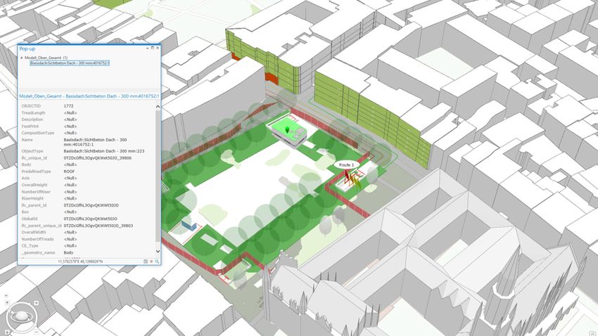
326                                           Journal of Digital Landscape Architecture · 6-2021

   current Esri products, for example, a direct import of .rvt files produced by the BIM
   Software Autodesk Revit is offered.
2) Data format conversion using ETL Tools (Extract Transfer Load).
   Tools like FME (Feature Manipulation Engine, by Safe Software Inc.) can be used to
   transform a variety of (geo-)data formats and include all common GIS formats as well
   as a variety of CAD and BIM formats. The approach offers more control and flexibility
   in the translation process and can therefore lead to more correct results than the mostly
   black box imports of approach 1). In the case of FME it also offers import logging for
   further control over the process. A visual comparison of the results of both approaches
   is shown in Figure 1.

Fig. 1: Results of a data conversion from a .rvt file using ArcGIS Pro (left) and FME (right)

Based on those insights, the second approach was used in the following two project examples.

3     Selected Projects
The practical application of a deepened BIM and GIS integration has numerous positive ef-
fects on the planning process. This can be shown using two examples by PSU, one being the
A99 expansion project, the other in the context of the Second S-Bahn Main Line in Munich.
From these two projects, we illustrate just a few extracts of the entire GIS-based environ-
mental assessments and the comprehensive BIM infrastructure project.

3.1   The A99 Expansion Project
For testing different workflows and data exchange procedures for the implementation of the
German Road Map for Digital Design and Construction, the German Federal Ministry of
Transport and Digital Infrastructure (BMVI) has launched a number of pilot projects (BMVI
2015). One of those is the eight-lane expansion of the Motorway A99 in the Munich Metro-
politan Region, commissioned by the Motorway Authority of South Bavaria and projected
by the SSF Engineering Group. The focus of this project lies on defining future requirements
for a frictionless information sharing between environmental planners and civil engineers in
J. Gnädinger, G. Roth: Applied Integration of GIS and BIM in Landscape Planning 327
order to incorporate all concerns into the engineering process from the start of planning, to
project implementation, to completion and monitoring of environmental measures.
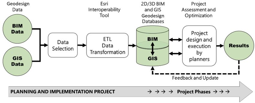
For achieving those targets, an integrated data exchange concept (Fig. 2) was elaborated. Its
key concept is the integration of the BIM planning process into a geodatabase structure. This
way the corresponding information can be exchanged and processed very quickly. For this
purpose, 2D and 3D CAD and BIM data were integrated into the GIS data model. By as-
sessing the GIS model, the parties were enabled to determine the potential impact of con-
struction projects on the environment as well as technical or infrastructural constraints.
Fig. 2: The integrated data exchange concept (PSU)
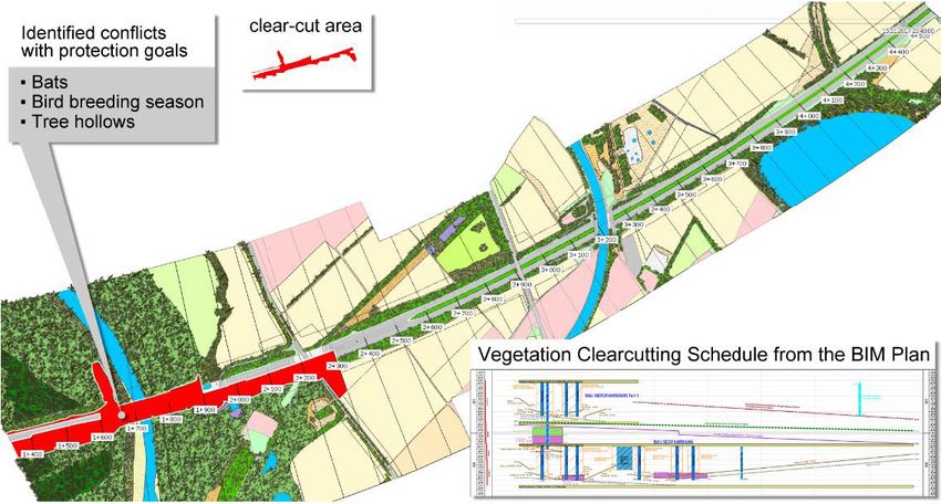
Fig. 3: Identification of potential conflicts between the BIM schedule for vegetation clear-
cutting and protected flora and fauna (PSU)
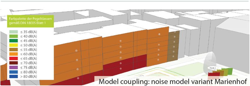
328                                            Journal of Digital Landscape Architecture · 6-2021

By applying this concept in practice, potential conflicts between construction planning and
ecological aspects can be identified (Fig. 3 for an example). The combination of the BIM
schedule for vegetation clear-cutting and protected flora and fauna allows the identification
and illustration of conflicts in spatial as well as in temporal dimension. This goes along with
the German Nature Conservation Act (BNatSchG) and German Building Act (BauGB) and
ecological requirements which state that every phase of the engineering planning process has
to be accompanied by specific environmental assessment, planning and monitoring proce-
dures.
As a key insight of this project we conclude, that – although there are still difficulties, like
implementing CAD geometries into the GIS dataset, e. g. with substantial amount of manual
editing required – the multitude of advantages of a close technical collaboration justifies any
effort.

3.2   Second S-Bahn Main Line (2nd SBSS)
The aim of the ongoing project 2nd SBSS is to create a GIS database that centrally bundles
all spatial data (inventory, current planning statuses and real-time data) and to make it avail-
able to all parties involved. For this purpose, various geographic and tabular data, reports and
surveys with spatial reference as well as BIM models for the entire route are converted, ho-
mogenized and linked using GIS and the ETL tool FME. An example of this integration is
illustrated in Figure 4.

Fig. 4: Integration of BIM Models in GIS at Marienhof (PSU)

This digital twin allows for advanced geospatial analyses including the up-to-date construc-
tion planning. At Marienhof, for instance, the integrated GIS model was used to simulate the
predicted noise generated by trucks with excavated material. Relevant noise data were ac-
quired from a professional noise survey and projected to the surrounding building facades
which were segmented by each storey. This led to a clear visualization of the impacts caused
by the construction activities and therefore enables decision makers to act accordingly. The
outcome also provided useful material for communicating relevant information to the public.
J. Gnädinger, G. Roth: Applied Integration of GIS and BIM in Landscape Planning 329
Fig. 5: Noise Model at Marienhof (PSU, Moehler + Partner)
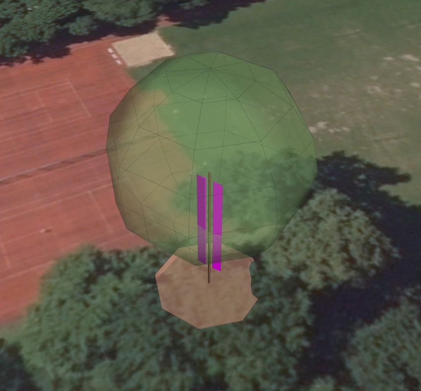
Another application from this project is the modelling of 3D trees including breeding cavities
for determining potential conflicts with infrastructure elements as shown in Figure 6. The
location and dimension of the trees are based on current field data collection and the BIM
construction models are always kept up to date within the GIS model. This allows for a rapid
collision detection and therefore for a fast feedback loop between the planners involved.
Fig. 6:
Tree with breeding cavi-
ties modelled in GIS for
collision control (PSU)330 Journal of Digital Landscape Architecture · 6-2021 4 Discussion The examples clearly show that the integration of BIM and GIS data is possible with state- of-the-art data transformation tools. Even though there are still some difficulties to overcome (like a substantial amount of manual work for transforming GIS geometries to BIM and vice versa), the benefits of shared data already outweigh those problems. The example of the 2nd SBSS provides some possibilities of using 3D data generated in both GIS and BIM software. With the exact representation of planned construction objects in the GIS model, the results of environmental analyses, like noise effects or species endangerment, directly refer to the predicted impact. By means of the 3D visualization, the existing situation, as well as the effects of the construction project on the environment, become directly per- ceivable. This results in a more intensive data exploitation as well as in a more convincing information transfer. The benefit of visualizing planning related information stored in BIM in a GIS not only in 3D but also in 4D gets obvious in the A99 example. The implementation of the clear-cutting schedule into the 3D model enables planners from other disciplines to directly understand potential effects caused by time collisions. For a seamless integration however, there are still some barriers that need to be overcome. Most of the tools only allow for an integration of BIM data in GIS software. In current pro- jects however it is required to also make the GIS data available in the BIM collaboration model. Due to the complex structure of BIM formats like IFC and unclear or missing defini- tions for GIS objects, the transformation from GIS to BIM still requires a lot of manual work and individual workarounds. This especially applies to the missing of standardized class cat- alogues for GIS objects like e. g. habitat types. This makes a productive and timely exchange of data still nearly impossible and therefore is one of the main reasons for the still existing delay of (seamless) model coupling. It also needs to be mentioned that the discussed methods as shown in the two case studies are mainly based on Esri and the connected BIM products. As of today, there are other BIM solutions that allow for a variety of workflows for integration of both methodologies. Those developments show how many opportunities this fast-changing technology offers but also outlines the need for standardized procedures and their integration into major software solu- tions to ease the overall collaboration between both worlds. 5 Conclusion and Outlook Several examples for coupling of data sets and models from different sources and planning contributions exist. There is evidence for the technical integration of 3D geometries and at- tributes from different professional sources, allowing to perform the required landscape and environmental analyses within a semantic 3D GIS data model. Within the BIM cycle, work- flows, data and information exchange have to be systematically developed for the planning phases of all environmental instruments and finally as standard procedures for planning prac- tice.
J. Gnädinger, G. Roth: Applied Integration of GIS and BIM in Landscape Planning     331

References
BMVI – German Federal Ministry Of Transport (Ed.) (2015), Road Map for Digital Design
   and Construction: Introduction of modern, IT-based processes and technologies for the
   design, construction and operation of assets in the built environment. BMVI.
   http://www.bmvi.de/SharedDocs/EN/publications/road-map-for-digital-design-and-
   construction.pdf?__blob=publicationFile (26.03.2021).
DB – Deutsche Bahn (2021), Building Information Modeling bei der DB Netz AG.
   https://www1.deutschebahn.com/db-netz-bim (09.01.2021).
DVW E. V. – Gesellschaft für Geodäsie, Geoinformation und Landmanagement & RUNDER
   TISCH GIS E. V. (Eds.) (2019), Leitfaden Geodäsie und BIM, Version 2.0, DVW-Merk-
   blatt 11-2019.
EUBIM TASKGROUP (2016), Handbuch für die Einführung von Building Information Mo-
   delling BIM) durch den europäischen öffentlichen Sektor.
FLAXMAN, M. (2010), Geodesign: Fundamentals and Routes Forward. Presentation to the
   Geodesign Summit, 6 January 2010, Redlands, CA. http://www.geodesignsummit.com/
   videos/day-one.html (09.01.2021).
MILLER, W. R., ESRI (2012), Introducing Geodesign: The Concept.
   https://www.esri.com/library/whitepapers/pdfs/introducing-geodesign.pdf (09.01.2021).
VAN NEDERVEEN, G. A. & TOLMAN, F. P. (1992), Modelling multiple views on buildings.
   Automation in Construction, 1 (3), 215-224. doi:10.1016/0926-5805(92)90014-B.
STEINITZ, C. (2012), A Framework for Geodesign: Changing Geography by Design. Esri
   Press, Redlands, CA.
You can also read