THE RISK IS IN THE DETAIL: HISTORICAL CARTOGRAPHY AND A HERMENEUTIC ANALYSIS OF HISTORICAL FLOODS IN THE CITY - RUA
←
→
Page content transcription
If your browser does not render page correctly, please read the page content below

Cuadernos de Investigación Geográfica
                                                           2021              Nº 47   pp. 183-219         EISSN 1697-9540
 Geographical Research Letters

                Copyright © 2021, The authors. This work is licensed under
                                                                                              http://doi.org/10.18172/cig.4863
                a Creative Commons Attribution 4.0 International License.

THE RISK IS IN THE DETAIL: HISTORICAL CARTOGRAPHY AND A
HERMENEUTIC ANALYSIS OF HISTORICAL FLOODS IN THE CITY
                        OF MURCIA

                                        SALVADOR GIL-GUIRADO1, 2*, JORGE OLCINA CANTOS 2,3,
                                          ALFREDO PÉREZ-MORALES1, MARIANO BARRIENDOS4

                   1
                       Department of Geography, University of Murcia, Campus de la Merced, 30001 Murcia, Spain.
                          2
                           Laboratory of Climatology, Interuniversity Institute of Geography, University of Alicante,
                                                                    San Vicente del Raspeig, 03690 Alicante, Spain.
                  3
                   Department of Regional Geographic Analysis and Physical Geography, University of Alicante,
                                                              Sant Vicent del Raspeig, 03690 Alicante, Spain.
                                                    4
                                                     Department of History and Archaeology, University of Barcelona,
                                                                              Montalegre 6, 08001 Barcelona, Spain.

ABSTRACT. The study of historical floods is a growing research trend that has generated numerous
methodologies that aim to convert the qualitative historical documentation into quantitative information. This
codification process aims to make comparable in time and space the manner in which past societies adapted to
floods, and so extract the positive or negative points that can help reduce vulnerability and increase the resilience
of current societies. However, the diversity of cultural and historical contexts, as well as the spatial-temporal
heterogeneity of documentary sources, makes it difficult to extrapolate quantitative methods in historical
climatology. This situation means that interpretative analyses of texts are still necessary as a complement to
quantitative studies. In this paper, we make a hermeneutic analysis of the three most catastrophic floods that have
occurred in the city of Murcia (south-eastern Spain) in the last 400 years. We complete this analysis with a
historical cartographic reconstruction of a quantitative nature. Among the main conclusions, we highlight the fact
that the society of Murcia had strategies to overcome catastrophes that included the whole of society and an
integrated emergency management. However, the state of poverty of privation prior to a flood is a determining
factor in explaining the resilience of a social system. A large increase in exposure of flood-prone areas over the
past two centuries is noteworthy but unsurprising. However, it is surprising that the percentage of urban area
exposed to flooding is now smaller than in the past. Therefore, if we consider hazard avoidance as a form of
management, we can say that pre-industrial Murcian society was less efficient in using the mechanisms available
to adapt to flooding.

El riesgo está en los detalles: cartografía histórica y análisis hermenéutico de las
inundaciones históricas en la ciudad de Murcia.

RESUMEN. El estudio de inundaciones históricas es una corriente investigadora al alza que ha generado
numerosas metodologías que persiguen transformar la información cualitativa contenida en la documentación
histórica, en información cuantitativa. Este proceso de codificación persigue hacer comparable en el tiempo y en
el espacio la forma en que las sociedades se adaptaban a las inundaciones en el pasado, con el fin de extraer los
puntos positivos o negativos que pueden ayudar a reducir la vulnerabilidad y aumentar la resiliencia de las
sociedades actuales. Sin embargo, la diversidad de los contextos culturales e históricos, así como la heterogeneidad
espaciotemporal del material documental, dificulta la capacidad de extrapolación de los métodos cuantitativos en
climatología histórica. Esta situación, repercute en que sigan siendo necesarios los análisis hermenéuticos de

Cuadernos de Investigación Geográfica, 47 (1), 2021. pp. 183-219                                                           183
Gil-Guirado et al.

textos, como complemento a los estudios de carácter cuantitativo. En este trabajo realizamos un análisis
hermenéutico de las tres inundaciones más catastróficas ocurridas en la ciudad de Murcia (Sureste de España) en
los últimos 400 años. Completamos este análisis con una reconstrucción cartográfica histórica de carácter
cuantitativo. Entre las principales conclusiones destaca el hecho de que la sociedad murciana tenía estrategias de
superación de catástrofes que involucraban al conjunto de la sociedad y que preconizaban una gestión integral de
las emergencias. No obstante, el estado de penuria previo a una inundación es un factor determinante para explicar
la capacidad de resiliencia del sistema social. En cuanto a la forma de exponerse al peligro, es destacable el gran
aumento de la exposición a zonas inundables producido en los últimos dos siglos. Esto no es algo sorprendente,
pero si lo es el hecho de que en el pasado el porcentaje de superficie urbana expuesta sobre el total fuera superior,
comparando con la situación actual. Por lo tanto, si consideramos la evasión del peligro, como una forma de
gestión, podemos afirmar que la sociedad murciana preindustrial usaba de forma menos eficiente los mecanismos
de los que disponía para adaptarse a las inundaciones.

Key words: Hermeneutic analysis, historical cartography, Huerta of Murcia, vulnerability, catastrophic floods.
Palabras clave: Análisis hermenéutico, cartografía histórica, Huerta de Murcia, vulnerabilidad, inundaciones
catastróficas.

                                                                                       Received: 4 September 2020
                                                                                         Accepted: 7 February 2021

*Corresponding author: Salvador Gil-Guirado, Department of Geography, University of Murcia, Campus de la
Merced, 30001 Murcia, Spain. Email address: salvador.gil1@um.es.

1. Introduction
        The history of society vs environment relationships is a process of frictions and imbalances in
the form of traumatic impacts. These imbalances can be understood as natural risks. However, the
complexity and multi-dimensionality of the factors involved in risk processes have determined
approaches to their study from historicist and/or positivist perspectives. This has created conceptual
problems around the definition of natural risk. The term is therefore conceived differently by researchers
depending on the paradigm they represent. While some propose natural risk as a mathematical product
that can be modelled and measurable in units; others argue that, as a human creation, risks have no
meaning outside the perceptual and social orbit. These two tendencies are evidenced through definitions
of the concept of risk.
         On the quantitative side, the definitions of natural risk focus on its quantifiable nature.
Villevieille (1997) writes that risk is the mathematical product of the probability of a hazardous event
occurring and the estimation of damage caused by such an event. Pita and Olcina Cantos (2000) describe
risk as an extreme phenomenon that produces negative impacts on the environment and society, and
which are the result of multiplying the value of the hazard by the damage caused (measured in monetary
units). Dauphiné (2001) defines risk as the product of the dangerousness and vulnerability that occurs
in a territory.
         With regard to the socio-perceptual aspect, definitions that consider the underlying human
character of risk processes stand out. Calvo García-Tornel (2001) points out that the measurement of
risk is always human. Beck (2002) goes further by indicating the social character of risks and argues
that risk is the modern approach to forecasting the consequences of human action. In this same line,
Giddens (2003) stresses that risks are creations of our growing knowledge about the world.

184                                                   Cuadernos de Investigación Geográfica, 47 (1), 2021. pp. 183-219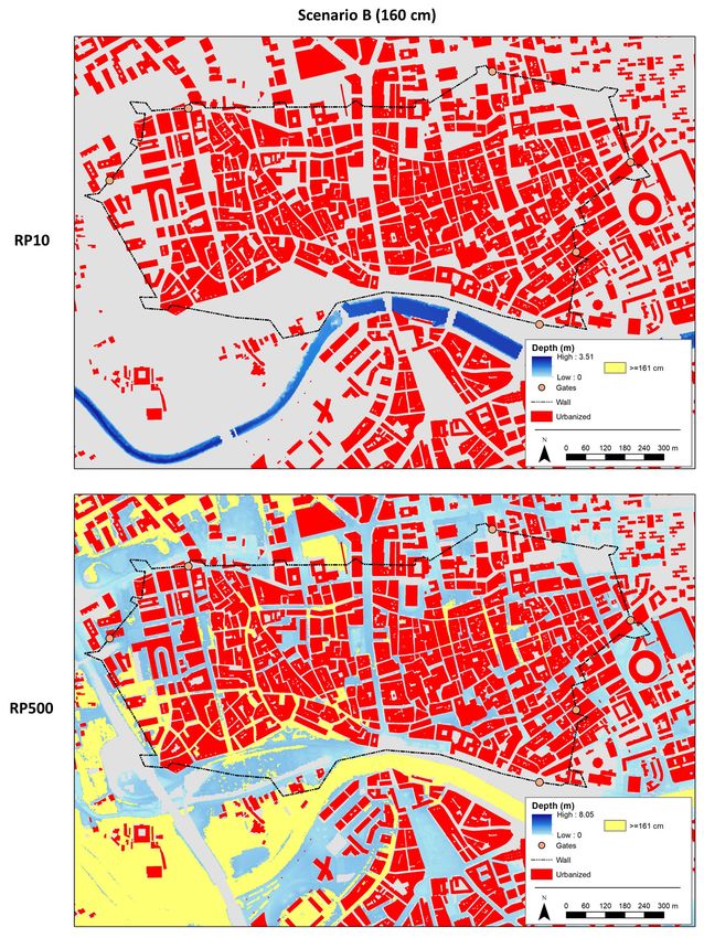
Cartography and analysis of historical floods

         If we approve the postulates of the social aspect, we can confirm that risk processes show the
characteristics of human behaviour that are poorly adapted to the natural environment, and so the natural
component of natural risks simply plays an explanatory role in the development of a hazard event
(Horacio et al., 2019). The aspect which should be emphasised is vulnerability – since a non-vulnerable
system is not exposed to risk and is optimally protected from danger. In contrast, a highly vulnerable
system makes any activity and any natural process a risky activity. This divergence explains the fact
that when faced with the same natural phenomenon, numerous damages are produced in some places
and no damages in other ones. Consequently, it is essential to act to reduce vulnerability to plan a
territory and protect people, especially in a scenario in which the recurrence of extreme events seems to
be increasing due to global warming (Grinsted et al., 2012). This is especially important for floods in
the Mediterranean region (Blöschl et al., 2020), where the role of people as catalysts for flooding
processes has also been significant in recent decades (Barredo, 2007).
        We must consider other important associated concepts of hazard, vulnerability, and exposure.
Hazard refers to natural processes that can damage society (Olcina Cantos, 2008). Vulnerability is the
expected differential impact in terms of intrinsic characteristics (such as political conditions, cultural
patterns, educational levels, and economic development) (López-Martínez et al., 2017). Finally,
exposure is the amount of property susceptible to damage by a natural hazard (Pérez-Morales et al.,
2018). The sum of these three factors is risk, to which we can add the intensity and duration of the
catastrophic event (Olcina Cantos, 2008).
         The concept of vulnerability is composite and multidimensional, as well as being subject to
social and political interpretations – and so the approach taken varies depending on the position of the
researchers. The concept can be discussed in ecological and environmental terms (Ollero, 2020), in
relation to political economics, or as a reflection of social relations and class structure. However, any
analysis of vulnerability must consider the social, economic, and organisational factors that influence
differing levels of vulnerability among societies (Endfield, 2007). In line with this, Calvo García-Tornel
(1997) states that vulnerability is the degree of effectiveness of a given social group in adapting its
organisation to those changes in the natural environment that includes risk. Brooks et al. (2005) argue
that vulnerability is represented by a set of socio-economic, political, and environmental variables that
affect the sensitivity and exposure of populations to environmental threats, and consider risk as the level
of possible deterioration caused by environmental events as measured by the sensitivity or vulnerability
of the exposed systems. The factors that determine the level of vulnerability in this conception depend
on environmental and social characteristics, the type of risk, as well as development aspects such as
poverty, health status, inequality, and political factors.
         The complexity of the interactions that determine vulnerability obligates to consider concepts
such as resilience and adaptive capacity. Smit and Wandel (2006) discuss the strong interconnection of
the concepts of adaptation, adaptive capacity, vulnerability, resilience, exposure, and sensitivity. The
term adaptation as applied to natural hazards can be defined as the ability of groups or individuals to
improve and add new methods to cope with environmental conditions based on their cultural repertoire
(O’Brien and Holland, 1992). Adaptation strategies are key points, as they are manifestations of
resilience (understood as the ability of a system to return to the situation prior to impact with the least
possible damage), and therefore represent a way to reduce vulnerability (Smit and Wandel, 2006).
         It seems clear that there is great heterogeneity in the definitions around natural risk, a
heterogeneity that has to do both with the complexity and multidimensionality of the problem of natural
risks, and with the epistemological approach of each researcher. In this respect, it is legitimate to think
that this heterogeneity will be greater if the aim is to study natural risks from a historical perspective
given that the economic, cultural, and social context is changing. Furthermore, the documentary sources
which enable us to study natural risks in the past are not spatially or temporally homogeneous. Therefore,
a hermeneutical approach in the study of historical risks continue to be essential to achieve a correct
contemporaneity of the events that occurred (Glaser and Kahle, 2020).

Cuadernos de Investigación Geográfica, 47 (1), 2021. pp. 183-219                                            185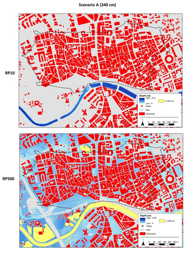
Gil-Guirado et al.

         Despite being a recent development, historical studies are beginning to play an important role
in the study of natural risk. Colten (1991) indicated that the reconstruction of a geographical progression
plays an important role in current environmental litigation, partly because it enables a path to be
followed in the management of crises, lessons learnt, and the evaluation of advances in knowledge of
the factors generating vulnerability among human groups (and so facilitating an understanding of risk
induction by societies). To show the most relevant aspects of social vulnerability, the most appropriate
scale for this type of analysis is local. To improve the territorial management of risks, it is important to
consider the variability of vulnerable populations to exposure to hazards (Cutter and Finch, 2007).
         The power of comparison and replicability of a methodology is mainly based on its objectivity,
and this is basically determined by the possibility of offering its results through numerical values
(Brázdil et al., 2018). For the study of natural risks in a historical perspective, historical climatology has
produced numerous methodologies for the reconstruction of natural disasters for different periods and
locations. For example, Prieto and Rojas (2012; 2015) develop works on how water extremes have
influenced some social processes in South America in recent centuries. Glaser et al. (2017) have done
the same for Central Europe, Brázdil et al. (2019) for Northern Europe, and Pfister (2011) for Western
Europe. To highlight only a few regions, Nash et al. (2019) explore the relationship between society and
natural risk in southern Africa, Barriendos and Rodrigo (2006) for the Iberian Peninsula, and Endfield
(2007) for colonial Mexico. Some works have explored the possibility of establishing quantitative
methodologies through contextual analysis (Gil-Guirado et al., 2016, 2019; Glaser and Khale, 2020;
Prieto and García Herrera, 2009; Diez-Herrero, 2020) with optimal results being obtained for regions
with a common history and culture. However, all the previous works coincide in indicating that without
a correct interpretation, the results remain unfocussed (Glaser et al., 2010) and therefore, it is impossible
to make a real comparison of past results with the present.
         The main methodological problems in historical risk studies refer to the heterogeneity of
documentary sources that makes it difficult to establish unified methodologies (Nash et al., 2019).
Cultural and religious divergences and socio-economic asymmetries also make difficult the comparison
of regions and periods. However, despite the fact that the study of historical natural risks involves
methodological difficulties and epistemological traps, there has been a certain unification of procedures
in recent years. In particular, the brand of historical climatology has favored this unification of
epistemological approaches with the common objective of learning from past natural disasters,
regardless of the quantitative or interpretative approach employed. In conclusion, work on historical
risks that aims to make considerations applicable today to improve the situation of people living in a
territory must be based on the quantitative method, while at the same time reflecting on the
hermeneutical nature of the interpretation of texts within social theory.
         In this work we carry out a hermeneutic analysis of the historical information relating to the
three major floods that affected the city of Murcia (southeastern Spain) in recent centuries. The San
Calixto flood of 1651, the Nuestra Señora de los Reyes flood of 1733, and the Santa Teresa flood of
1879. In each of the centuries studied, these events were the greatest natural catastrophes caused by
flood. The analysis of historical documentation shows numerous events and situations that helped or
hindered the management of these disasters. From the quantitative point of view, we carried out a
cartographic reconstruction thanks to the maps available from the beginning and end of the nineteenth
century (Olcina y Diez, 2017). The aim of this cartographic reconstruction is to differentiate the effects
of the floods in the nineteenth century from the current situation, both in absolute and relative terms. To
do this, we digitised the available historical maps to establish the urban space in the nineteenth century
and compare it with the urban space today. Finally, we digitised the perimeter of Murcia’s medieval city
wall and considered that its main role was to protect against flooding. We assigned a probable height to
the wall based on archaeological work and using the height of the flood water for various return periods,
and then we determined the type of flooding that the medieval wall could have withstood today.

186                                                Cuadernos de Investigación Geográfica, 47 (1), 2021. pp. 183-219
Cartography and analysis of historical floods

        This cartographic analysis is new and enables the first quantitative comparison between the
historical and current flood zones in the study area. A hermeneutic analysis, together with quantitative
methodologies, enable us to establish the spatial, social, and historical reality of the floods in Murcia.
The aim is to find out directly whether the trajectories of adaptation led to greater or lesser vulnerability
and resilience to flood risk over time (Messerli et al., 2000).

2. Sources and methodology
        Due to the intrinsic characteristics of flood risk and considering its instantaneous and perceptual
magnitude, it is possible to speak of disasters or catastrophes in terms of greater or lesser affects (Olcina
Cantos, 2008). The floods analysed in this work are considered disasters due to the number of deaths,
the great social impact, and amount of destruction caused.
       It is necessary to differentiate between two types of data sources: firstly, historical sources; and
secondly, data sources of present time. Historical sources have been used for hermeneutic and historical
mapping analysis, while data sources of present time have been used to analyse flood hazard and
exposure as a basis for mapping analysis.
        For the hermeneutic analysis of the flood of 14 October 1651 (San Calixto Flood); the flood of
6 September 1733 (Nuestra Señora de los Reyes Flood); and the flood of 14 October 1879 (Santa Teresa
Flood), historical sources are used. The bulk of historical documentation corresponds to the Municipal
Chapter Book (MCB). The MCB is an internal municipal document that textually collects all the
decisions of the councillors and mayors who met regularly in municipal council meetings. This type of
source is the best way to directly observe unfavourable climatic events (Perez Picazo et al., 1980). In
this type of document, the extractable information focuses on the consequences for the population of
severe weather events and climatic anomalies (Gil-Guirado, 2017).
        The second historical source are newspaper. Newspaper sources have been widely used for the
reconstruction of historical floods (Rashid, 2011; Gil-Guirado et al., 2016; Barriendos et al., 2019). In
this paper, newspaper sources are only available for the 1879 floods and the local newspapers of the
time were consulted. In addition, various files, books, expert reports, and chronicles have been consulted
– and these constitute the third source of historical documentation used. All the above documentation is
available at the Murcia Municipal Archive (MMA) and the Murcia Provincial Historical Archive
(MPHA). The analysis of historical maps has been mainly based on the maps made by the Spanish Army
during the Spanish War of Independence (1808-1814). These maps offer a high level of detail for the
period and are available on the online portal of the MCU (2020). In addition, historical maps were
consulted in the Hispanic Digital Library online portal (Biblioteca Digital Hispánica) and other maps
were found in files and reports available from the MMA.
        Methodologically, the hermeneutic analysis is focused on a critical review of historical sources
consulted. Following other works, a contextual analysis of the texts is the main analysis tool of this
methodology (Pfister, 2011; Nash et al., 2019; Glaser and Kahle, 2020).
        With regard to the quantitative methodology we use data sources of present time and historical
cartography in a combination of the methodologies proposed by Pérez-Morales et al. (2018) and Prieto
and Rojas (2012) has been followed for the map analysis. Two factors need to be considered spatially
for the historical and current assessment of flood exposure: the physical component (natural hazard);
and the human component (Cardona et al., 2012). Information on the former has been obtained from
data contained in the National System of Flood Zone Mapping (SNCZI by its acronym in Spanish) of
the Ministry of Ecological Transition and Demographic Challenge (MITECO, 2020). This has been
developed by the ministry, following the principles in the European Directive 2007/60 on the assessment
and management of flood risks for river space management, risk prevention, and territorial planning.
This source provides the results of hydrological modelling in vector format for various return periods

Cuadernos de Investigación Geográfica, 47 (1), 2021. pp. 183-219                                            187
Gil-Guirado et al.

(10, 50, 100 and 500 years). Models have been used for 10 (RP10), 50 (RP50), 100 (RP100) and 500
years (RP500). The information for the return period (RP) reports the surface occupied by water in each
return period, and the height of the water in centimetres.
         For the analysis of the current human component, buildings were considered in the form of
cadastral plots available at the electronic headquarters of the General Directorate of Cadastre – part of
the Ministry of Treasure (MH by its acronym in Spanish) – with data updated in 2019 (MH, 2020). The
cadastral sources consulted were urban plots for each municipality in the study area. In relation to land
occupation in the nineteenth century, the map of 1809 entitled ‘Plan showing the Huerta of Murcia
prepared for flooding if it is threatened by invasion of the capital by enemies’ by Pablo del Villar is
(available in the MECU, 2020) has been georeferenced and digitised. This map has served to indicate
the study area of the historical region of the ‘Huerta of Murcia’. A ‘huerta’ is a Spanish word describing
an irrigated area with small well-defined plots for growing a variety of vegetables and fruit trees. Huertas
are a type of market garden and are often found beside waterways near towns and cities in Spain. This
map shows the main urban areas of the time in the study area. Despite the great level of detail in this
map, the reality of the period may not be fully shown.
         The area occupied by the historical medieval wall of the city of Murcia has been georeferenced
and digitised based on the ‘Plan of the fortification of Murcia’ by Manuel Rodríguez Hita (1812) and
available in the MECU (2020). Once the old wall was mapped, the height of the wall above the current
level of the city of Murcia was established on the basis of various archaeological works. The difficulty
of establishing a set value has led us to model two height scenarios. Each of these scenarios has been
intersected with the height of the water for various RPs (10 and 500 years) to ascertain the magnitude
of the floods that the wall could have protected against. According to Montes Bernárdez (2002) the
medieval wall that still stood in 1837 was between 3 and 5 metres above the current level of the city.
Other archaeological works (Navarro Santa-Cruz and Robles Fernández, 2002) indicate that in some
sections, the wall was 6.5 metres higher than the current height of the surrounding streets at the time of
its construction. Similar figures are given by Aguilera and Megías (2014). These authors state that the
height of the wall at present is 3.4 metres above the current height of the street and a primitive ground
level of -3.7 metres would produce a total wall height of more than 7 metres. In this work we consider
plausible a homogeneous wall height of 3.4 metres above the current height of the city (Scenario A).
However, Frey Sánchez (2000) indicates that most of the walls were 4.1 metres high when they were
built. If we consider that, in a conservative scenario, the city has risen 2.5 metres above this original
level, the wall would be 1.6 metres above the current city level (Scenario B).
        In addition, the digitalisation of the map entitled ‘Sketch of the Huerta of Murcia; sections into
which it is divided: surface occupied by the flood of 15 October 1879, height that the waters reached in
the flood and approximate statistics of the losses suffered’ by Juan Belando (available in the Hispanic
Digital Library, 2020) gives us a more approximate idea of the spatial impact of this event.
        Finally, and to complete the cartographic comparison, the digitisation of the previous maps
together with the digitisation of a current satellite image, has allowed us to analyze the changes in the
course of the River Segura in the vicinity of the city of Murcia between 1809 and the present.
        The maps have been made using the free QGIS software (QGIS Development Team).

3. Study area and historical background
         The city of Murcia was founded on the initiative of Abderramán II in 825 AD. It is located on
the left bank of the Segura River, on a strangled meander. The city was founded to establish a habitable
and stable point from which to control the area and exploit the fertile lands of the valley, while being
sheltered from the greatest threat in the area, flooding. To do this, it was necessary to make a huge effort

188                                               Cuadernos de Investigación Geográfica, 47 (1), 2021. pp. 183-219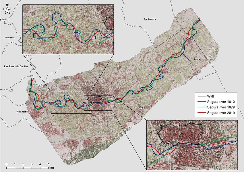
Cartography and analysis of historical floods

to control the irregularity of the flows of a river that often abandoned its course to create new meanders
(Lillo Carpio, 2000).
         The region is characterised by low rainfall (slightly less than 300 mm) with eight dry months, a
summer drought, and marked inter- and intra-annual irregularity. In addition, average annual
temperatures are high (over 18º C) with hot summers and mild winters. These conditions increase water
stress for human populations and biotic communities, as the months with the greatest water demand
correspond to those with the lowest river flows and the lowest rainfall. The months of June, July, and
August (Gil-Guirado and Pérez-Morales, 2019) are especially critical in this regard. Until a few decades
ago, the predominantly agricultural economy and the calendar of local crops revolved around this natural
system and the variability it produced.
         The current municipal district of Murcia occupies 885.5 square kilometres, and historically two
distinct areas have coexisted within this large territory. Firstly, the city itself, as well as its huertas and
surrounding villages; and secondly, the ‘county of Murcia’ with population centres far from the city and
a generally distinct economic behaviour that is subject to rural traditions, and where dry farming has
always surpassed irrigation.
        The agricultural nature of the city and its surroundings has been – as in all ancient settlements
– the key factor in the location of activities, which in this case and given the climatic conditions, has
resulted in ‘water determinism’ above all other needs. This situation had the effect that in the city of
Murcia, the defensive needs of a territory that was on the border between the ancient Christian and
Muslim kingdoms were secondary. The city walls were conceived as a defence against floods, rather
than military attack (Fig. 1). Consequently, in the city of Murcia, control of the surrounding space from
a high defensive position has not been a priority.
         The medieval wall of the city of Murcia has its origin in the period of Muslim rule and it was
built between the eleventh and twelfth centuries. Although the main role of medieval walls is usually
defence against enemy invasions, the case of the city of Murcia is an exception since the main role of
the wall has always been as a defence against river flooding (Roselló Verger and Cano García, 1975).
Already in the seventeenth century the Murcian humanist and scholar Francisco Cáscales pointed out
that the wall of Murcia was built to defend against enemy attacks, and protect against floods and
epidemics (Cascales, 1621). García Antón (1993) highlights the key role played by the wall in protecting
the city from the flooding of the River Segura. However, it was Torres Fontes and Calvo García-Tornel
(1975) who best described the defensive role of the city walls against flooding.
         However, recent change in the size of the city has meant that the huerta has gone from being
farmland for horticultural products consumed in the city, to an area of urban land reserve, and so
changing the basic organisational scheme of the traditional huerta. This area was characterised by
environmental factors that generated a historical region and a variegated landscape, homogeneous as a
whole, and differentiated from surroundings by the use of irrigation. The territory presents a historical
and spatial continuum that goes beyond political-administrative divisions, since, although most of the
huerta is included within the municipality of Murcia, the historical territory of the ‘Huerta of Murcia’
stretches into parts of five other municipalities (Molina de Segura, Alcantarilla, Santomera and Beniel
in the province of Murcia, and Orihuela in the neighbouring province of Alicante) (Fig. 2).

Cuadernos de Investigación Geográfica, 47 (1), 2021. pp. 183-219                                            189
Gil-Guirado et al.

  Figure 1. a) Plan of the fortification of Murcia (1812) by Manuel Rodríguez Hita; b) Current map of the city
   of Murcia, layout of the river and the Arab wall. Source: MCU, 2020. Note: the River Segura is coloured
                  blue, the wall is red, and the urban area is highlighted in pink by the authors.

190                                                 Cuadernos de Investigación Geográfica, 47 (1), 2021. pp. 183-219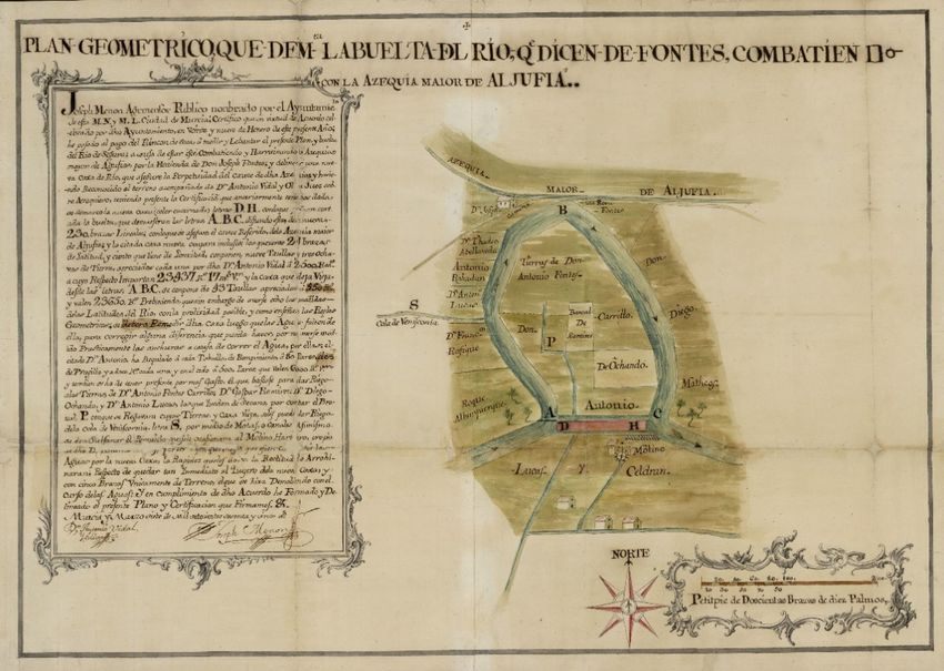
Cartography and analysis of historical floods

    Figure 2. Study area. Notes: The perimeter of the study area corresponds to the historical region of the
  ‘Huerta of Murcia’. The delimitation of this area has been made on the basis of an 1809 map entitled ‘Plan
 that shows the Huerta of Murcia, prepared to be flooded if the capital is threatened with invasion by enemies’
                              by Pablo del Villar available in the MCU (2020).

         It can be seen how the River Segura, the huerta and the city of Murcia are intertwined in the
functions of the metropolitan area, with a large part of the area being used for commercial purposes,
except for some vestiges of irrigated crops (Fig. 2). This area corresponds to the Murcia Pre-coastal
Depression, which is formed by of the River Segura and its confluence with the River Guadalentín. The
alluvial plains – where farming is established – are made up of gentle slopes and fertile alluvial soils.
The River Segura flows into the area in a NW-SE direction, with the width of its valley increasing as it
approaches the city of Murcia. The Guadalentín flows naturally into the Segura, forming a large alluvial
fan, a continuation of the valley floor, which runs along the Alhama fault in a SW-NE direction.
However, in 1747 the Canal del Reguerón was opened to divert the River Guadalentín so that it did not
join the River Segura upstream of the city. The edge of these valleys is marked by low hills.
        The Huerta and the city of Murcia form the study area in this work and represent a part of the
natural region identified with the valley of the River Segura after gaining width downstream from
Archena and running between hills until reaching the neighbouring province of Alicante.
        The natural confluence of the Guadalentín and Segura should be highlighted since the risk of
flooding has determined the management guidelines of this area for centuries. This junction occurs
upstream of the city in the place called ‘Paso de los Carros’ a few kilometres from the small town of
Sangonera. The area forms a large alluvial fan (about 30 km2) in which the topography and regime of
the river increase the risk of the river leaving the riverbed (Fig. 3). This is a determining factor in the
exposure and danger of this territory to flooding. Throughout the history of the city, strategies have been
in place to mitigate the risk that the torrential flow of the Guadalentín imposes on these lands (Calvo
García-Tornel, 1969).

Cuadernos de Investigación Geográfica, 47 (1), 2021. pp. 183-219                                             191
Gil-Guirado et al.

  Figure 3. a) Geomorphological map of the confluence of the Segura river and the Guadalentín river in the
 city of Murcia and b) topographic profile. Source: Mapa Geomorfológico de España 1:50.000, IGME (2020)

         This is the dual relationship that gives continuity and differentiation to the study area, given that
it is characterised by the dominance and structural control of water, in order to escape from droughts
and mitigate the natural lack of rainfall, while at the same time, controls are necessary to avoid sudden
floods. Apart from the national and international economic and political context, these factors have
determined the possibilities for regional growth, given that disasters are a burden, but the need to
mitigate them is an incentive. Historical periods of development in the area, followed by population
increases, were followed by periods of depression and stagnation as it was impossible to satisfy these
new demands with the existing technology for farming and building structures to control water (Pérez
Picazo et al., 1980). The origins of this process go back to the introduction of the irrigation system in
the eleventh century – which has survived, practically intact, until the end of the twentieth century (Ros
Sempere and García Martín, 2012).

192                                                Cuadernos de Investigación Geográfica, 47 (1), 2021. pp. 183-219
Cartography and analysis of historical floods
4. Results
4.1. The Flood of San Calixto in Murcia (14 October 1651)
The San Calixto flood of 14 October 1651 in Murcia was the most disastrous of the seventeenth
century and, together with that of Santa Teresa in 1879, is one of the two floods that caused the most
damage to the city.
Caused by intense autumnal rains, the sudden overflow of the River Segura caught the
population unprepared (it occurred during the early hours of the morning – which was a repeated feature
among catastrophic floods of the time). The damage reports tell us that the flood came from both the
River Segura and the River Guadalentín, so the episode of rainfall was widespread throughout the River
Segura basin (or at least in the W and NW areas). During the early hours, the city’s population focused
on reinforcing, with the means available, the city's defences to prevent an overflow, but a lack of
resources compromised the effort.
Floodwaters ran through the city streets for three days. It was not until the fourth day that the
city council was able to meet to assess the situation, which gives an idea of the size of the disaster. At
an extraordinary meeting of the municipal council on 18 October, the members made a preliminary and
desolate assessment of the damage. On the 19th (a Thursday), after a more thorough survey, the
magnitude of the disaster was understood: buildings collapsed; livestock dead; defences swept away; a
network of ditches destroyed; roads cut off; and worst of all, there were hundreds of fatalities. Such was
the state of ruin that there was an exodus of survivors to higher parts of the Segura valley. The dire
financial situation of the city increased vulnerability due to a lack of funds for repairs. Finally, it was
agreed to accept the aid of the Crown with the subsequent exemption from taxes, the arrival of experts
to assess damages, and funds allocated to help victims (Annex A. Doc. 1).
Damage to infrastructure was immediately followed by supply problems and a rise in food
prices. As was normal in a disaster, neighbouring cities offered help. The first to offer was nearby Mula,
despite the fact that it also suffered significant damage. One of the Crown’s measures was to create a
tax for all the towns of the old “Kingdom of Murcia” -territorial jurisdiction belonging to the Crown of
Castilla- according to their population size to fund the reconstruction of Murcia city. The city council
also required all the residents, without apparent distinction of social class, to collaborate in the repair of
roads and flood defence infrastructures.
One month after the flood, the streets were remained under water and full of mud. This seriously
affected commerce. In addition, buildings were continuing to collapse due to the accumulation of
humidity. More than two months later the situation seemed even worse: the irrigation system continued
to further deteriorate, food was scarce and expensive, the river began to occupy new spaces in the flood
plain (and so mills could not grind grain), and the population continued to abandon the city for other
towns. In this context, the same manager actors indirectly pointed out that the state of vulnerability prior
to the event was partly responsible for the hardship caused by the disaster (Annex A. Doc. 2).
The city seems to have overcome the worst some four months after the disaster. A thanksgiving
ceremony was held (Annex A. Doc. 3). However, the infrastructure remained damaged for many more
months. It seemed that during this period one flood was never completely overcome, when another
occurred. Thus, when another severe flood arrived in 1653, the flood damage from 1651 had not yet
been repaired. This flood of 1653 was preceded by another flood of lesser size that damaged the defence
systems (Annex A. Doc. 4).
Considering the means available, the systems of prevention, control, and assessment of the
threat were fairly well developed in Murcia. The problem was the socio-political and economic context.
It is worth noting that even four centuries ago, floods were considered a risk that required specific
prevention measures. Thus, at the end of the summer, city officials began to revise the irrigation and
defence system in anticipation of the autumn rainy season (Annex A. Doc. 5 and Doc. 6).
Cuadernos de Investigación Geográfica, 47 (1), 2021. pp. 183-219 193Gil-Guirado et al.
The first month after a disaster is the period when emergency work peaks, although repair work
continues more than a year later. However, the first six months are when the greatest social impact is
felt. Given the lack of resources, territorial problems remained considerable throughout the period and
were difficult to resolve (especially the repair of the irrigation network and defence systems). From one
year after the flood, adaptation measures in anticipation of future floods gain priority.
With regard to the danger, there is little information on the environmental cause of the flooding.
Most of the relevant information refers to the high level of the river, and to a lesser extent, to the
torrential rains and the large amount of material washed away. The seriousness of the situation forced a
major effort to manage the catastrophe, help the victims, and regain stability. Most of the information
refers to measures of this type. In terms of infrastructure, it was the irrigation system and, above all, the
flood protection infrastructure that was most affected. Consequently, the economic disruption to farming
and the problems of irrigation water supply were significant. Deaths and injuries deserve a special
mention. Given the magnitude of the disaster, little importance was given to these issues in comparison
with today. This was perhaps because the high mortality rates of the time, and low life expectancy,
meant life was not considered as important as it is today. It is necessary to note that past perspectives
and perceptions are being assessed under a current prism. At a socio-political level, it can be said that
the entire social structure was affected (including urban and rural inhabitants, nobles, religious orders,
merchants, and the rich and poor).
The lethal flood of San Calixto in 1651 was an important precedent for risk management in
general. Constant municipal requests were made to the Crown for aid and tax exemptions (a type of
declaration of disaster) and all the social agents affected were actively involved (Annex A. Doc. 7 and
Doc. 8). Both high-ranking nobles and knights sent someone to work on their behalf in the recovery
from the disaster. This possibility was open to all nobles, but if they did not have the money to pay
somebody, then they had to work themselves. The repercussions among the ruling classes transcended
the real needs of overcoming the disaster. Churchmen began an open battle against the knights and the
city council. During the ceremony of thanksgiving for having overcome the flood, the priest complained
that church officials did not have anybody they could send to work on their behalf – unlike nobles. In
this way, the priest claimed in a populist manner that he shared the suffering of the common people
(Annex A. Doc. 9). In this way, the reality that elites have appropriated legitimate popular responses to
injustices, al every historical moment, and deflect the initial intention by introducing new actors
according to their private interests. It is also evident that the generalisation of risk processes is not a
specific consequence of modernity, as suggested by Beck (2002).
Historical documentation shows how the authorities sometimes blamed the rural population,
mill owners, animal breeders, and even some town councillors, for faulty maintenance of the irrigation
network and flood defence systems. Speculators were also blamed for food shortages. However, the
frequent occurrence of floods in Murcia, together with the scarcity of available means, meant that people
blamed nature for traditional problems that could not be avoided or prevented. Proposals made to
overcome the disaster included important improvements to the destroyed irrigation and defence network
as well as financial aid.
4.2. The Flood of Nuestra Señora de los Reyes (6 September 1733)
The flood of Nuestra Señora de los Reyes occurred on 6 September 1733 and was probably the
most catastrophic of the eighteenth century. As in the previous century, flood defences were in a
deplorable state. The inability to maintain the defences in an efficient and diligent manner, heightened
the vulnerability and explained the major impact of the flood. Although the flood was much less
damaging than the San Calixto Flood, it caused considerable stress for Murcia city and the huerta.
Suffice to say that less than one month before the flood and despite the fact that the autumn rainy season
was approaching, the irrigation system had been damaged, but excessive bureaucracy and a lack of funds
194 Cuadernos de Investigación Geográfica, 47 (1), 2021. pp. 183-219Cartography and analysis of historical floods
prevented an immediate repair (Annex B. Doc. 1). Nevertheless, between 1651 and 1733 some
improvements had been made to the protection systems, such as a straightening of meanders to give
greater linearity to the river as it passed through the city. However, limited technical and financial
resources compromised the effective application of these improvements, and above all, their
conservation. The imposition of the wishes of local landowners over the public interest also played an
important role in the situation prior to the flood (Annex B. Doc. 2).
On 6 September, an intense, continuous, and widespread rainfall led to a rise in the waters of
the River Segura. Despite attempts to hold the banks, an overflow could not be avoided. Unlike in the
case of the San Calixto flood, where the flood peaks came from both the River Segura and the River
Guadalentín, the main part of this flood came mainly from the Guadalentín, and so it was less dangerous
and the flows were less extreme. The immediateness of the response, the smaller scale of the flood, and
because it occurred during the day, prevented a catastrophe with devastating consequences. Given the
means available, the damage mitigation strategy was fairly successful in the beginning of the emergency,
when rapid response groups were established to fix the damage to the defence systems and thus avoid
further damage (Annex B. Doc. 3). Nevertheless, damage was considerable: mainly to crops; the
irrigation and defence systems; and roads. Many homes and entire neighbourhoods were flooded. The
poor quality of the buildings in the huerta led to many structures being washed away, and there were
numerous deaths, although in much smaller numbers than a century before. Once again, the lack of a
stable fund to provide for these frequent disasters made an immediate relief response difficult and left
the local council without funds. There were immediate problems of food supply given the loss of crops,
the destruction of crops, as well as the road closures and impossibility of milling. The result was
shortages, hunger, and a major rise in the price of bread. In general, the urgent measures taken followed
the same procedures as in the seventeenth century (Annex B. Doc. 4)
The notable difference between this event and that of 1651 is that while in the earlier episode it
was necessary to wait four months to celebrate a church procession of thanksgiving for having saved
the city from the flood, in this episode the ceremony was held just six days later. Reports said that the
waters had mostly receded, and convents and some streets were already passable (Annex B. Doc. 5).
As in the seventeenth century, a damage report (which was perhaps exaggerated) was sent to
the Crown. Two weeks after the flood, measures began to be taken to prevent further damage, and these
focused on reducing meanders and rebuilding and improving the defence and irrigation systems. A lack
of resources forced landowners to pay the costs of reconstruction. Landowners who refused or delayed
were threatened with exclusion from these improvement works. Despite these efforts, 20 days later, the
huerta and the city were still without water for irrigation and household use because of the breakdown
in the infrastructure and the accumulation of sediment in the pipes.
On 30 September of that same year, another small flood made recovery more difficult. The
warning systems were activated, and effective measures were established. In this case, the flood came
from the River Segura and occurred gradually, due to rainfall in the upper river basin, and so there was
time for the municipalities upstream of the city of Murcia to report the threat. In the end, the flow was
less than expected, and the measures prevented another overflow (Annex B. Doc. 6). From November
onwards, reports about this event began to decrease in the municipal records. During the following
months, work continued on flood defence, irrigation, and road repairs. In March 1734, a relative
recovery from the catastrophe was formally announced.
Awareness of the danger of flooding had increased in comparison to the seventeenth century,
and more thought was given to preventing disasters and establishing adaptation strategies. High water
levels were considered responsible for the flooding by many observers, but there was an increasing focus
on the torrential rains, and above all, the materials washed away by the river, as the cause of the damage.
At the same time, some observers remarked that the real problem lay in the high level of erosion of the
local materials. The most significant damage was to the irrigation infrastructure. However, there was
also significant damage to roads. After these damages, the effects on farming, the occasional flooding
Cuadernos de Investigación Geográfica, 47 (1), 2021. pp. 183-219 195Gil-Guirado et al.
of land, and the difficulties in evacuating water were significant problems noted in the municipal
records.
Murcia's dependence on official assistance and financial credit, and the lack of foresight, led to
serious economic problems. The lesser intensity of the flooding led to a reduction information in relation
on fatalities and injuries compared to a century earlier. The inability of local government to critically
assess risks and the greater level of intervention in the territory with the better level of understanding of
environmental mechanisms than a century before, led to the blame being generally placed on nature.
However, there was increasing awareness of human action as being responsible for the impact of
flooding. In this respect, the technicians responsible for reviewing the infrastructure were blamed for
the deficiencies in the defences.
Among the measures proposed to overcome the disaster, technological improvements with
respect to the seventeenth century enabled the use of new construction techniques to reduce
vulnerability. However, the key measure against floods continued to be the improvement of irrigation
and flood defence infrastructures.
4.3. The Flood of Santa Teresa (14 October 1879)
The Santa Teresa flood was the most catastrophic flood ever recorded in Murcia. The material
damage was incalculable, and the victims were counted in hundreds. The worldwide response to the
distress of the Murcian people was unprecedented (Botrel, 2019).
The flood was caused by an intense rainfall that lasted more than two days and was widespread
throughout the river basin. The flood peaks that reached the city came from the River Guadalentín, as
well as from the rivers flowing towards the right bank (Rivers Mula, Quipar, Argos, and Moratalla) and
also from the left bank of the River Segura.
The severity of the Santa Teresa flood made it necessary to manage quickly the catastrophe. The
Murcia City Council held five consecutive days of extraordinary sessions (October 15, 16, 17, 18 and
19) to deal exclusively with the management of this flooding.
On 15 October the city was completely flooded, the newspapers echoed the disaster and given the
impossibility of beginning the relief efforts, they reported on the first bureaucratic responses, such as the
creation of a Relief Board (a similar in effect to declaring a catastrophe). From the very beginning, it was
feared that the damage to the huerta could be much more serious than in the city (Annex C. Doc. 1).
A news story in El Diario Información on 16 October reported: “10,000 farmers have
undoubtedly lost everything they had on this sad night; and soon they will come to our streets to tearfully
ask us for charity, and the authorities must help them and give bread to those who are hungry. Today
the King, the Government, the whole Nation, must know that this unfortunate city has been left poor
and miserable; today the voice of Murcia will be heard throughout Spain asking for help for an immense
number of its children who have lost everything.”
Within the city of Murcia, the areas near the left bank of the river were the most affected. The
San Benito neighbourhood (in the southern part of the city) was the first to be flooded, and as the
epicentre of the catastrophe, the destruction was total. The water reached the city centre, flooding the
entire San Pedro neighbourhood. The prison, the cathedral, and the neighbourhoods of San Juan and San
Andrés were also flooded. The situation was worse in the huerta, with bodies scattered in the fields near
to the city. The district of Nonduermas was completely inundated, as were the districts of Era Alta,
Beniaján, Alquerías, Aljucer, Rincón de Seca, La Alboreja, San Benito, El Raal, Urdienza, and Puente
Tocinos. By the 16 October, some 113 deaths were already reported despite the fact that the most
affected areas were yet to be reached. In January of the following year, the official figure for victims
was given as 148, although with the many missing people, the number was probably some 300 for the
196 Cuadernos de Investigación Geográfica, 47 (1), 2021. pp. 183-219Cartography and analysis of historical floods
capital and huerta. In Orihuela, in the neighbouring province of Alicante, bodies from Murcia were
found in the river.
The disaster attracted widespread attention in Spain and abroad, and King Alfonso XII visited
the affected area on 20 October. The mobilisation of international charity was unprecedented, especially
from former Spanish colonies and those that still remained (Cuba, the Philippines, and Puerto Rico).
France also sent considerable aid, where the Parisian press gave considerable coverage to the event,
creating a fund to help those affected and a lottery to raise funds. Help was most immediate from the
other towns in the River Segura basin and the rest of Spain – and began arriving just two days after the
flood.
Press sensationalism exaggerated the effects and made it difficult to obtain a clear idea of the
magnitude of the damage (Annex C. Doc. 2 and Doc. 3). More than 20,000 hectares of the Huerta of
Murcia were submerged, and much material was carried away by the water. In some places once the
water was drained, the accumulated sediments reached almost two metres in height (Figure 4). The
destruction was almost total and the damage incalculable.
Until October 22, the authorities only sought to provide relief, and from this moment onwards
they began the work of rebuilding the flood defence and water distribution systems, while at the same
time, they started to propose measures to avoid a repetition. These measures usually involved public
works (Annex C. Doc. 4).
Newspaper reports noted a new class consciousness in the nineteenth century, differentiating
between poor day labourers, landowners, and the rest. The improvement in individual and political
freedoms, together with the relative freedom of the press during the reign of Alfonso XII, is evident in
a greater critical capacity that pointed directly to several social practices as responsible for the
destructions caused by the flood. However, following the flood, corporatism and political control of the
media were also felt. On 16 October 1879 the ‘Diario de Murcia’ supported the ruling political powers
and security forces with a front-page story that commentated: ‘yesterday throughout the huerta we saw
how all the councillors, the Civil Guard, firefighters, and security forces, as well as hundreds of members
of the public, continued to provide relief to those in need’. The newspaper went on to suggest that the
cause of the flood was divine: ‘It seems that God is angry at the city of Murcia’. The political support
was confirmed on the 19th: ‘We repeat that in Murcia there has been no authority, nor individual with
responsibilities, who has not done everything that could be done’. To this position was added an
ultraconservative opinion that considered the poor – who were accused of numerous vices and bad
habits – to be responsible for the social problems. A news story published on 25 October 1879 in El
Diario de Murcia is the best example of this, and it also indirectly illustrates some of the secular
problems of the population of the Segura Valley, such as a lack of a spirit of protest, conformism, and
religious faith (Annex C. Doc. 5). This news story is almost an insult and serves as an example of how
social tensions were increased by the flood. The same newspaper was also forced to respond to criticisms
made by the more progressive and educated sections of Murcian society – who were too afraid to
publicly make their observations (Annex C. Doc. 6).
From December 1879 onwards there were constant problems in the distribution of aid, and it was
said all of the donated funds were being made available. Most of the funds were donations from individuals
and were given to help the neediest, but it seems that a part of this aid was re-directed to help large
landowners and the upper classes. Again, some sectors of the local press showed their support for local
cronyism and so evidenced that social problems were an important factor of vulnerability. It also became
clear that the most conservative sectors were the least inclined to spend funds on improving adaptation and
resilience, and were opposed to reconstruction beyond the safest areas (Annex C. Doc. 7). Nearly three
months after the flood, a realistic assessment of the number of people affected was made, and it highlighted
that 9,332 people in the huerta had not yet been provided with clothing (while 20,000 had been given
clothes). However, reports on the amount of damage were still contradictory (Annex C. Doc. 8).
Cuadernos de Investigación Geográfica, 47 (1), 2021. pp. 183-219 197You can also read