The Road to Warenburg - Interpreting a Village with Maps and Images Created by Richard Kisling in collaboration with Ronald Brott
←
→
Page content transcription
If your browser does not render page correctly, please read the page content below
The Road to Warenburg
     Interpreting a Village
     with Maps and Images

Created by Richard Kisling in collaboration with Ronald Brott
               Presented by Richard Kisling

    American Historical Society of Germans from Russia
            Virtual Conference, July 13, 2021
Acknowledgements
  Thanks to the following individuals for their specialized help and support in preparing this presentation.
        Ronald Brott, Ankeny, Iowa: Warenburg Village Coordinator (history), ron.e.brott@gmail.com
      Sharon White, Taylorsville, Utah: Warenburg Village Coordinator (genealogy), slmwhite@aol.com
         Natalia Chumakova, Saratov, Russia: information on Warenburg and about her grandmother,
                    Leocadia Yanovna Tokareva (“Leocadia Peterson” in this presentation)

               Permissions for use of photographs: Aleksandr Bashkatov, Saratov, Russia; Denis
               Anikin, Saratov, Russia; Historischer Forschungsverein der Deutschen aus
               Russland, Nuremberg, Germany; Landsmannschaft der Deutschen aus Russland,
               Stuttgart, Germany; the online newspaper, “Общественное мнение” [public
               opinion], Saratov, Russia; Anton and Vitaly Koshkin, Saratov, Russia.
                        Richard Kisling, Petaluma, California, kislingrichard@comcast.net

This slide deck is available as a PDF on the conference website under the title “The Road to Warenburg Presentation, 2021 Conference.”
             It will be moved the Warenburg Village File on AHSGR’s new website when the site is launched the fall of 2021.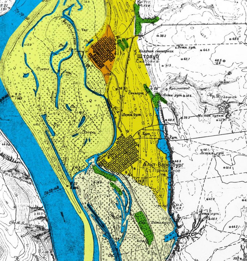
Our Route | Unser Weg
Presentation                                                                  Resources
Location                                                                      Genealogy
  • On the Tarlyk River                                                           • Village Coordinators, Surname Charts,
Surroundings                                                                        Translated Records, Engels Archive
  • Between the Volga and the Steppe                                          Warenburg in Print
Church                                                                        Topographic Maps and Aerial Photographs
Village                                                                           • Tips for Acquisition/Usage (all regions)*
  • From the Air                                                                  • Matrix of Topographic Maps (Volga Region)
  • From the Ground                                                           Supplement
The End of Warenburg                                                              • Church, Government, and Commerce
  • Deportation, September 18, 1941                                               • Insurrection of 1919
  • Privolnoye’s (Warenburg’s) Last Germans                                       • 1:200,000 Topographic Map
        • Leocadia Peterson (1924– )                                           Endnotes
           *Preliminary assessment of LOC’s map indices indicates extensive coverage of the Black Sea area, especially 1:50,000 scale maps.

 This slide deck is available as a PDF on the conference website under the title “The Road to Warenburg Presentation, 2021 Conference.”
              It will be moved the Warenburg Village File on AHSGR’s new website when the site is launched the fall of 2021.
                                                                                                                                              3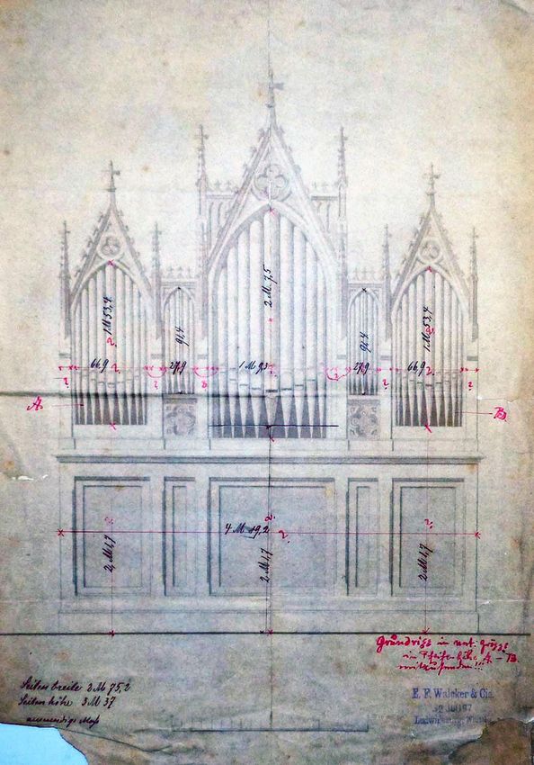
Points of Interest| Sehenswürdigkeiten
Along the way … | unterwegs …                                       Interim Destinations | Zwischenziele
• Maps—especially 1930s topographic maps from                         • Learning by all audiences: Warenburgers, AHSGR
  the USSR: symbols, labels, elevations                                 veterans, newcomers
• Historical and contemporary village photos,                         • Understand something about Warenburg’s
  newspaper headlines, statistics                                       history, setting, and way of life
• German reconnaissance photo from 1942                               • Be able to compare Warenburg to other colonies
• A few words in the German language                                    you may know
• Warenburg Middle School “Class of 1941”                             • Gain some experience with topographic
     • Leocadia Peterson                                                maps and aerial photos
     • Alexander Bier (extensive writing)                             • Increase your knowledge and empathy
     • Alexander Schmal (photos, writing based on his                   regarding the Russian Germans
       diary)

 This slide deck is available as a PDF on the conference website under the title “The Road to Warenburg Presentation, 2021 Conference.”
              It will be moved the Warenburg Village File on AHSGR’s new website when the site is launched the fall of 2021.
                                                                                                                                          4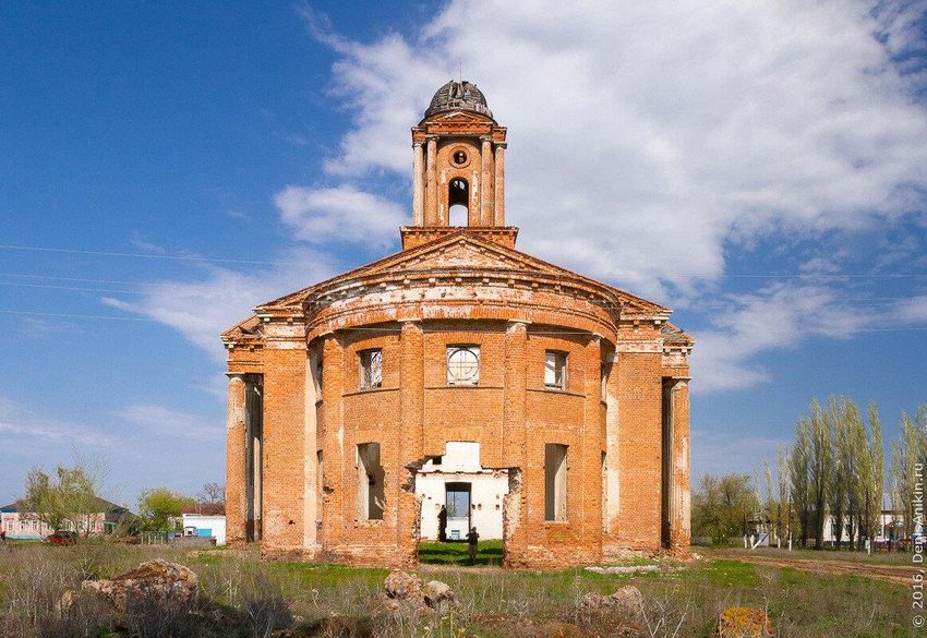
The Location—on the Tarlyk
Die Lage—am Tarlyk
Tarlyk Colonies, Population, Land Holdings

                                             5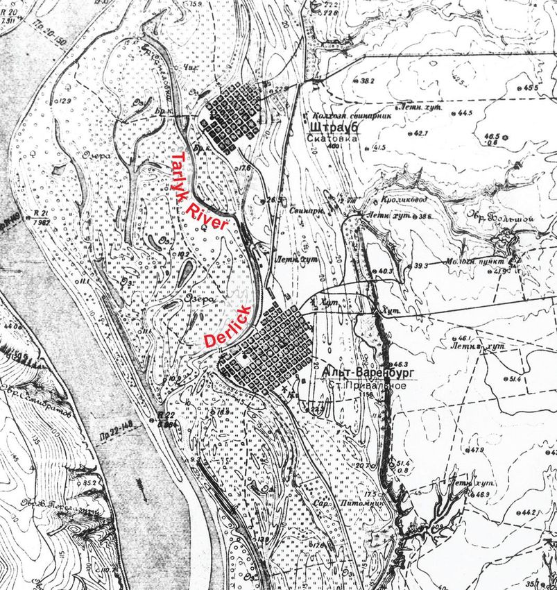
MAP 1.0 Stumpp Map/Volga Colonies (excerpt)

On the Tarlyk—am Tarlyk
Warenburg was founded May 12, 1767, one of sixteen colonies
established May–August by the recruiters LeRoy and Pictet.
   • These colonies were successively called LeRoy’s Second District, the
     Warenburg District, and then “on the Tarlyk” or am Tarlyk.
         • The Tarlyk River ran about 30 miles off the Steppe, flowed between Laub
           and Dinkel, joined the Volga River.
Warenburg not named for its first Vorsteher, Johann Heiter (Geiter)
   • Example: the “colony of Vorsteher Straub” (Johann Heinrich Straub)
     became merely “Straub”—a widespread practice in the Volga colonies.
   • Warenburg was named by the recruiters, who warehoused goods—
     Waren—here for distribution, thus the name “Waren-burg.”
   • The colony was often called “Alt-Warenburg” (Old Warenburg) after it
     established daughter colonies called Neu-Warenburg (New Warenburg).
   • The Russian name was—and still is—Privolnoye.
Warenburg was 50–50 Lutheran and Reform, unique in the colonies.
 Note: On this map, (e) indicates evangelisch, Evangelical or more generally, “Protestant”; (k)
 indicates katholisch, Catholic; (m) indicates mennonitisch, Mennonite; Kukkus and Seelmann are
 underscored twice, as they headed cantons in the Volga German Republic.
 This map, Stumpp’s 1:600,000 map from 1954, is available from AHSGR, “Map #06 Volga.”

                                                                                           6
MAP 1.1 Stumpp Map/Volga Colonies (excerpt edited)

                                                                         Tarlyk Neighborhood History
                                                                         Low point for the Tarlyk colonies in 1774
                                                                              • August: the Pugachev rebels swept through these colonies from the
                                                                                north, stole horses, murdered colonists.
                                                                                     • In Warenburg, they killed six, hanged Vorsteher Ihlner.
                                           Daughter                           • October: the Kirghiz-Kaizak attacked Hölzel, Leitsinger, Keller, and
                                           Colonies
                                                                                Seelmann; the number of those killed, abducted, missing was 438.
                                                                                     • Leitsinger and Keller were destroyed; survivors re-built at Neu-Kolonie,
                                                                                       downriver from Seelmann, in 1776.
                                                                         Mennonite colonies were settled 1854–1872 on the Lake Elton Salt
                                                                           Tract (“am Trakt”) mostly east of the Lake Elton Salt Road.
                                         Mennonite Colonies “am Trakt”
                                                                                     • The extension of the salt road to Pokrovsk is not shown on the map.
                   Neu-Warenburg ●                                       Warenburg’s daughter colonies
                Ansiedlung Priwalnoje
                                                                              • Ansiedlung Priwalnoje and Neu-Warenburg on the Steppe
                                     ●                                        • Neu-Warenburg, founded in 1902 just north of Seelmann, appears by
                                                                                its Russian name, Novoprivolnoye, on contemporary maps.
                                                 Daughter Colonies        Note: Added daughter colony names and locations from A. Mergenthaler’s 1:420,000 map, AHSGR
                   ● Leitsinger                                           “Map #04 Volga”
                  ● Keller
                                                                          Tip: Use Google Maps/satellite view or Google Earth to see remnants of the original street grids of the
                                                                          several Tarlyk colonies that have been abandoned or relocated from their inundated original sites to
                                                                          higher ground.

● Neu-Kolonie                                                                                                                                                             7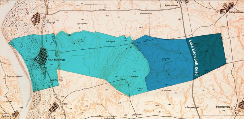
Population and Land                               MAP 2 Straub, Warenburg, Preuss | Warenburg’s Land
                                                  Warenburg’s land encompassed some 48,650 acres (19,688 hectares) and extended
 Ten Most Populous Volga Colonies in 1912         17.4 miles (28 km) from the Volga River. The average width was 4.4 miles (7 km). This
                                                  was about 76 square miles (197 square kilometers).
       Colony               1772      1912
   1. Norka                    957    14,236      The three sections of land holdings shown below, from the west:
   2. Katharinenstadt          283    11,962       • Holdings identified in the 1798 Census, extending 10.9 mi (17.5 km) from the Volga
   3. Grimm                    769    11,778         River
                                                   • Additional lands likely acquired between 1798 and 1840
   4. Frank                    525    11,557
                                                   • Land east of the Lake Elton Salt Road, likely acquired after 1840
   5. Balzer                   479    11,110
   6. Huck                     380     9,600
   7. Jagodnaja Poljana        402     8,845
   8. Dönnhof                  470     8,830                        Straub
   9. Warenburg                579     8,312
  10. Seelmann                 257     8,089
Of the almost 200 mother and daughter                                                                                          after
                                                                                      1798 Census             1798-1840
colonies in the Volga region, only three of the                                                                                1840
                                                                    Old-Warenburg
ten largest colonies were on the Meadow Side:
• Katharinenstadt, which became successful
  with small industry and shipping;
• Seelmann, which became large and wealthy
  because of grain shipping from its docks;
• Warenburg, which did not industrialize and                             Preuss
  whose docks were impeded by the large sand
  island, but still remained large and wealthy.     Base Map: Soviet 1:100,000 map from 1934, excerpt from Sheet M–38–45 (National Archives)

                                                                                                                                               8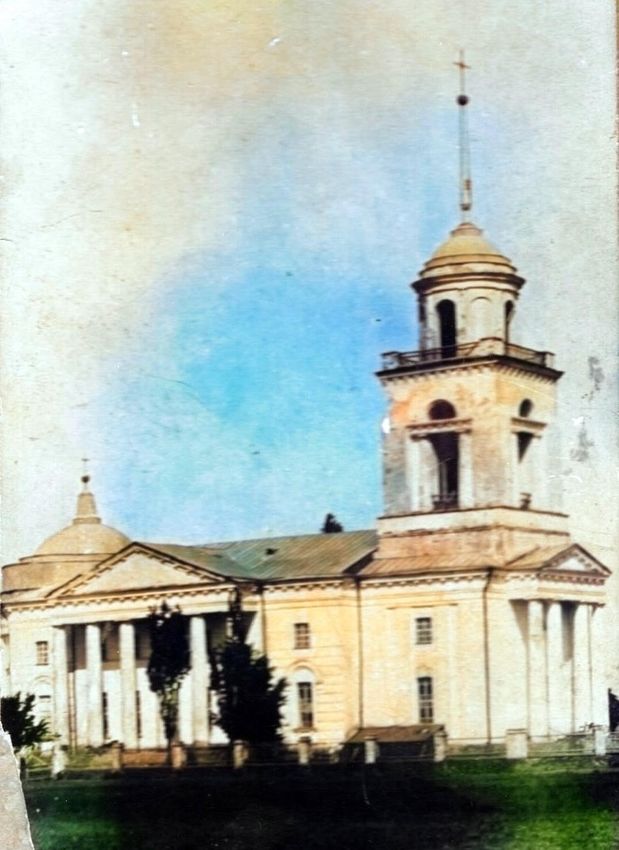
The Surroundings
Die Umgebung
Between the Volga and the Steppe—Flooding, Meadow, Orchards, Gardens, “Derlick”

                                                                                  9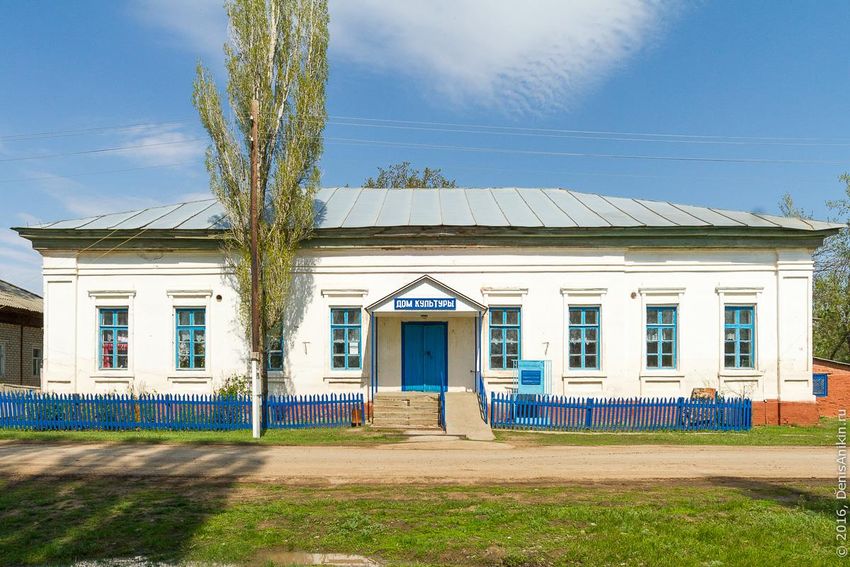
10
MAP 3.0 Soviet 1:100,000 Map
Excerpt from Sheet M–38–45

Primarily Symbols                                                                       Straub
The villages Straub and Old Warenburg
                                                                                                 Großer Graben |
 • Mountain Side (Bergseite) hills                                                               “Big Gully”
 • Volga River, sand island, “saton”
 • Meadow (Wiese), grassland, deciduous
   trees, many lakes and ponds
 • Country highway (Landstraße)
        • new north-south highway farther east
• Orchards and cabbages                                                                  Alt-Warenburg | Old Warenburg
        • apples and cherries south of Warenburg
        • cherries northeast of Warenburg
        • cabbage patches east of Warenburg
          (described near standing water)
                                                                              Dubovka
  • The vast steppe (farmland) to the east                                                 pitomnik | (plant) nursery
Soviet 1:100,000 map from 1934 from Library of Congress (LOC) and AHSGR
Tip: Use online Russian keyboard, online translator for short translations.
                                                                                                                   11
MAP 4.0 Soviet 1:50,000 Map
Excerpt from Sheet M–38–45–A 1
Symbols and Labels
Straub
Grasses, lakes, deciduous trees on meadow ADD LOCATION OF OPENING PHOTO
• The Tarlyk River labeled by name
2
• joined the Volga seven miles north between 3
Laub and Dinkel 7
• also meandered southward through the 4
meadow past Straub and Warenburg
• called the “Derlick” in Warenburg
• Footpaths across the Derlick and meadow 5 6
• Buildings and infrastructure
1 pig collective 2 pigs 3 rabbits
4 summer khutors 5 wind/mechanical mills
8 Old Warenburg
6 standing water (cabbages) 7 orchards 7
8 cemetery (кладбище, kladbishche)
9 sheds (сараи, sarai),
(plant) nursery (питомник, pitnomnik)
(former fairgrounds)
Soviet 1:50,000 map from 1932 available from LOC 9
Tip: Consult guides online for abbreviations and symbols.
12Pre-1961 May–June Flood, Summer Meadow
Before 1961, the Volga River at Late-May/early-June, the river The resulting meadow was used
low water was an easy walk flooded as deep as 10 ft (3 m), for recreation, fishing, cattle
from Warenburg. then receded. grazing; lush grasses for hay.
Note: There were also soggy conditions and localized flooding in these villages in March when the ground thawed, the snow melted, the gullies and creeks ran
with water, and the ice on the Volga River broke up.
13MAP 4.1 Soviet 1:50,000 Map
Excerpt from Sheet M–38–45–A
“Walking Distance”
“An easy walk” from the Church
• south to cemetery: 0.75 mi (1.2 km)
• south to the fairgrounds: 2 mi (3.25 km)
• east to the cabbages: 1.5 mi (2.5 km) Cherries
• east to the base of Steppeberg: 2 mi (3 km)
• northeast to cherry orchards: 2.3 mi (3.75 km)
Cabbages
• north to the Straub church as the crow flies:
3.4 mi (5.5 km)
• west to the river: 1.7 mi (2.85 km)
Steppeberg
• north-northwest to the Volga: 4.6 mi (7.5 km) Cemetery
Other Distances
• up the Steppeberg Ramp: 0.16 mi (250 m)
• width of Volga River: 0.75 mi (1.2 km)
• Volga to east boundary: 17.4 mi (28 km) Fairgrounds
Note: The villagers would not have harnessed a team of horses for a light
errand. These walks were favorite activities for Sunday afternoons when
no one could work with a team and wagon.
14MAP 4.2 Soviet 1:50,000 Map
Excerpt from Sheet M–38–45–A
Multiple Elevations
Elevations
• Bergseite hills (Wolgaberg): 475 ft (145 m)
• Studjonkaer Kopp: 885 ft (270 m)
• Volga River: 11.5 ft (3.5 m)
• Meadow (die Wiese)
• lower northern section: 36–39 ft (10–12 m)
• higher southern section: 36–55 ft (10–17 m)
• Village and area east: 66 ft (20 m)
• Straub somewhat lower: ~49 ft (15 m)
• Standing water east of the village
• Steppeberg: 132–169 ft (40–51 m)
• ascent to the Steppe was higher at Warenburg
• hillside approximately 39% grade
• old graded ramp approximately 11% grade
• Steppe: as high as 216+ ft (66+ m)
• farmland to the east
Note: The Studjonkaer Kopp (not shown)—west of the now-
abandoned Russian village Studyenka/Стчдеика (Studjonka in
German)—was the tallest Bergseite peak visible from Warenburg.
Read more about it in the endnotes.
15MAP 4.3 Soviet 1:50,000 Map
Excerpt from Sheet M–38–45–A
Environment: 8 mi2 (21 km2)
die Wiese (Meadow): low and flat St e p p e
• deep, long flooding: 10+ ft (3+ m) for weeks
• no gardens or orchards: recreation, grazing, hay
• large area of grasses, herbs, flowers, trees, wildlife
der Grund (Bottoms): not as low and flat
• shallower, briefer flooding: 0–10+ ft (0–3+ m), days–wks
• orchards/nursery survived no/short flooding
• gardens planted in June after the high water
• Süßholz (licorice) roots dug in the Grund
Kalmücker Grund (Kalmyck Bottoms): higher
• no flooding, rich soil, shallow water table
• soil temperature warm enough in May for gardens
• May was slack time—mäßig Zeit—between wheat
planting and rye harvest.
• large, production gardens
• tons of cabbages harvested near the standing water at
base of Steppeberg
Note: The environment is measured from the Volga River east to the
Steppeberg, and from Warenburg’s southern to northern borders as
shown on the 1:100,000 map earlier in this presentation. 16The “Derlick”
The Tarlyk, the “Derlick”
(Dellig):
• crossings to the meadow: a
bridge at the channel (der
Kanal) and a ford at the
hollow (die Höhle)
• source of domestic water
• shallow places to wash the
horses, water the cattle
• an area of sandy beach for
swimming in summer
• places for ice skating and
sledding in winter
Hollow
Photo above left: the Derlick at high
water, end of May 1941, by Alexander Bridge
Schmal. Boat occupants—all members
of the “Class of 1941”—from the left:
Alexander Roth, Georg Wagenleitner,
Leocadia Peterson, Marta Wasmuth,
Emma Stumpf, Beate Elsässer, Philip
Doering, August Becker. Location of
photographer is unknown; likely
perspective is facing the village.
Photo above right: the Derlick at low
water by an unknown photographer.
See map underlay for probable location
and angle of camera shot.
17The Church | Die Kirche
Church Street, the Kontor Style, Interior, Pipe Organ, Tower and Dome, Soviet Era
18Church Street
in Warenburg
“Kirchenstraße von Warenburg”
This is the “classic” Warenburg photo circa
1908–1911.
Church Street—the main street—was a part
of the country highway (Landstraße) that
connected all the Meadow Side
(Wiesenseite) colonies.
The Lower Village (Unterdorf) was the
colony’s center of gravity, with the church,
parsonage, three schools, colony and volost
(Kreis) offices, numerous businesses, clinic
(1870s), and small hospital (around 1910).
The two-story building on the left was the
Brott School (die Brotteschule) at this time.
Notes:
• Kirchenstraße was also called Kirchengasse.
• In Warenburg the Lower Village included these blocks in front of the church and the whole area behind the church.
Photograph by an unknown photographer. Often reversed, the orientation of the photo shown here is correct, according to witnesses and aerial photos.
19Warenburg Church
A large, neoclassic-style brick church building that seated 1,200
• The Kontor (office) for Foreign Settlers in Saratov mandated neo-
classic church architecture until it closed in 1874.
• the Kontor Style (Kontor-Stil) to the colonists
• after 1874, churches built in a variety of styles
• Most churches were wooden, larger churches were often brick.
• The Warenburg church is a good example of this style:
• colonnaded front portico and side porches with shallow, empty pediments
• massive, fluted columns to support the porches
• pilasters on the exterior walls
• large-scale, three-story tower with cupola; needle spire with ball and cross
• cross (small churches) or dome (large churches) over the sacristy
• The iron fence with the stone columns was likely from 1911.
Note: A sacristy is a (usually small) room behind the altar where the pastor or priest Photo of the church circa 1908–1911 from the collection
prepares for the church service. of the Krikau family, Elgin, Illinois; filtered and colorized
by George Miller, Naperville, Illinois.
20Inside the Church
Photo: Pastor Eduard Seib, posed in front of the
altar holding the elements of the Lord’s Supper
• Raised and carpeted chancel surrounded by the
communion rail
• Lutherans knelt at the rail to receive communion;
Reform members stood.
• “Swallow’s nest balcony” pulpit over the altar
• stairway up to the pulpit located in the sacristy
behind the altar
• unknown inscription on the arch over the pulpit
• Balcony and side galleries
• Prescribed seating: village dignitaries in front,
men on left, women on right, young single men in
the balcony and galleries
• seating further sequenced by birth year with older
people toward the front
Photographer unknown. This photo has been reversed in some publications.
The photo is shown here in its correct orientation, based on the Christogram
“IHS” on the front of the altar cloth. 21Drawings from E.F. Walcker Ogelbau:
The Pipe Organ Right: the display pipes and the
wooden casework crowned with
• installed in the church decorative gothic towers
balcony by E.F. Walcker Below: console, configuration of pipes,
wind supply
Orgelbau, from Ludwigsburg,
Württemberg, Germany in
1898
• fifteen-rank organ with two
manuals and pedalboard
• neo-gothic wooden casework
about fourteen feet across,
nineteen feet tall at highest
point (image, far right)
• foot-operated levers as wind
supply (required second
person)
• schoolmaster was organist
and choir director
22The Tower and the Sacristy Dome, Construction Date
In earlier photos, the round or octagonal
Eighteen forty-three has been the accepted construction date
third level of the tower is deeply set back for the church. Superintendent Pingoud’s 1909 report from
from second level. There is a circular dome the general consistory in St. Petersburg, for example,
over the sacristy. describes an 1843 brick church in Warenburg seating 1,200.
In later photos and in the current ruin, the Other traditional references echo this date (see endnotes). Dr.
tower’s third level is square and taller. The Sergey Terjochin describes an 1843 building to which
columns at the corners and the new cupola improvements were made after 1908, including a new fence
appear to have been built around the old
and poplar trees, renovation of the tower, and fluting of the
tower. There is no dome over the sacristy.
columns, etc.
Nature may have played a role: Alexander
Bier says the tower was struck by lightning in Dr. Olga Litzenberger’s magisterial book on the Volga colonies
1912 and repaired before World War I. presents a detailed and convincing narrative about a new
Kontor-Style brick church in Warenburg, which was started in
1905 and consecrated in 1910. The interior had pews for
1,200 believers, balconies, pulpit, altar, and three crystal
chandeliers. It was heated by three cast-iron ovens from
Holland.
This sounds like a splendid church! However, this description
Photo above (circa 1908–1911): does not account for the differences in the tower and sacristy
Warenburg church showing a smaller roof. (see left).
tower and a circular dome over the
sacristy. Note: A church seating 1,200 was too small for a village with a
Photo right (Soviet Era): the population of 8,300; several contemporary churches were twice the
Warenburg church with the new tower size or even larger: Norka, Hussenbach, Schäfer, etc. There is also
speculation about why the community would install a new pipe organ
and no dome over the sacristy. in 1898 then begin construction on a new church only seven years later.
23The Church During the Soviet Era
• The final three men who served as pastor were arrested, the
last in 1931 while he was pastor in Warenburg.
• May 1935, the cross was pulled down from the tower.
• March 1937, the church was officially closed.
• July 1937, a huge wheat harvest; the church used as a granary
• The Communist Red Star was positioned on the top of the
tower.
• The bells were removed, the pipe organ was carried off.
• The church was used as a club (theater performances) until
1939.
• In 1943, a Machine-Tractor-Station was set up in the church
building, operated by the prisoners of a corrective labor camp.
• They bulldozed or hammered a large entrance in the sacristy wall
to permit driving equipment in and out.
• Village legend: Two of the three men who installed the red star
on the top of the former church fell off the tower and sustained
Photo by Denis Anikin, 2016: Warenburg church with hole in the
fatal injuries. In another version: None of the men fell, but all sacristy wall.
their families experienced some misfortune within a year.
24The Village | Das Dorf
From the Air: Aerial Photos and Village Plan
From the Ground: Parsonage, Schools, Houses
25Warenburg in German-Flown Aerial Photography
Photo below left: Warenburg, visible in the lower right corner. Straub, a little less than four miles north, is barely discernable in the morning sunlight; compare
this to maps earlier in this presentation for orientation. Photo below right: a corner of Warenburg with footpaths crossing the Derlick and meadow.
October 8, 1942, Sortie 1862, Photo 220 Photo 220 (enlarged view)—Paths, Lakes, Trees, Haystacks
The German-Flown Aerial Photo were captured by the Allies at the end of World War II and became a part of the United States National Archives’ collection.
26Warenburg, One Year After the Deportation
Photo below left: enlargement of the Warenburg street grid, clearly showing larger buildings like houses, stores, and schools. Wholesale destruction of buildings
for heating material came later at the height of WWII. This photo shows the village as we left it a year earlier. Sketch below right: street plan with buildings.
Photo 220 (enlarged view)—Warenburg Street Grid Village Plan Sketched from the Photo
The National Archives’ collection of reconnaissance photos in the USSR includes shots of a number of German villages in the Volga and Black Sea regions.
27MAP 5 Sketch of Village Plan
Village Plan, Lower Village
The village plan, left: Warenburg with about 150 identifications contributed by Heinrich Kisling,
Leocadia Peterson, Alexander Bier, Marie Christine Doering Leisle, Anna Lofing Brott, Alexander
Schmal, Wilhelm Funkner, and others. Excerpt below: part of the Lower Village
N
28Upper Village School
• Warenburg maintained two village schools, both
with ~300 pupils and one teacher.
• short school year: October–March
• Teachers’ other responsibilities
• maintained the church registers
• rang the church bells
• performed baptisms and funerals
• led the church service when the pastor was away
• played the organ and led the choir
Photo above right by an unknown photographer: a historical photo of a
building with 10 windows often identified in print as the Warenburg “Upper
Village School”
Photo below right by Ronald Brott from 1995: the actual Upper Village School—
a building with 9 windows just like Warenburg’s Lower Village School— which
was built on a street corner
29Brott Store/School and Home (1995)
This building was the Brott Store and then the Brott School. We saw The Brott House is directly to the right of the Brott School. This is
it in the “Church Street” photo in a prior slide. The building was a another shot from 1995. Note the hip roof, shutters over the
store when this photo was taken in 1995: the sign says “products.” windows, the light blue paint around the windows, and the carved
The building still stands on Church Street. flourishes over them.
30Parsonage
One of Warenburg’s most-photographed
houses
From Dr. Olga Litzenberger:
• built by the community in 1907
• walls eighteen inches thick
• large gate with fancy brickwork
• ceilings with delicate stucco decorations
• the last pastor arrested in 1931
• After that, leaders of the collective farms lived
here.
• 1943 to 1953, the head of the corrective labor
camp that was set up in Warenburg lived here.
• private residence today
• village legend: tunnel to church
Photo: Denis Anikin, 2016
31Lower Village School
• Church services were held here in winter, also weddings,
baptisms, funerals (referred to as the Bethaus).
• Month-long preparation for confirmation—approximately
275 confirmands in Warenburg Parish (the colonies Laub,
Dinkel, Straub, Warenburg, and Neu-Warenburg).
• procession from school to church on Pentecost Sunday
• The Large Community Council met here to make major
decisions.
• a village governing body with a representative from each of the
800 households
• Today
• house of culture and community center, space for receptions,
dances, movies, etc.
Photo above right by Alexander Schmal, 1941: store, school, health clinic (Polyklinik), village
soviet (Dorfsowjet), houses
Photo, below right: Denis Anikin, 2016
32Miller (Müller) Villa
Heinrich Müller, an early Vorsteher, made his
fortune transporting Lake Elton salt to Pokrovsk
(Engels).
• Salt was a state monopoly; traders and agents
were used for distribution and sales.
• His son became one of the region’s most
successful grain traders.
• Later descendants bought the land of the
Mennonite colony Hahnsau (c. 1881), resold it
at a profit (c. 1900), and then started a
successful trading company.
• The Miller Villa (photos, right) was a
showplace, with German finishes, furnishings,
and artwork.
Photo above right: Alexander Schmal, 1941
Photo below right: Aleksandr Bashkatov, 2010
33Miller (Müller) School
The Miller family moved away; they had business
ventures in other parts of the empire.
They gave the family home to Warenburg for use as a
school in the early 1900s.
The villa was used for Warenburg’s “middle school”
(secondary school) in the 1930s (photo above left).
Alexander Bier: “A graceful arched gate and two built-in
street doors connected the summer kitchen with house’s
main entrance and with the two-story side building.
Service buildings surrounded the Hof. The whole
ensemble of buildings gave the impression of urban
buildings.”
Photo above left by Alexander Schmal, 1941: the Warenburg Middle School
Photo below left by Denis Anikin, 2016 (cropped): the new entrance and wing to
the left
34The “Little Miller House”
• The Miller Villa is still the
largest building in
Privolnoye.
• The connecting wall and
large gate have been filled
in with new construction
to the left of the new
entrance.
• It is still a school today,
and the only building in
Privolnoye whose name—
the “Little Miller House”—
is carried over from the
German colony
Warenburg.
Photo: Denis Anikin, 2016
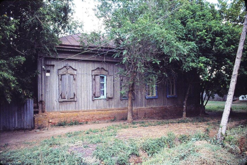
35Warenburg’s German Houses
Notched-corner log construction
• many with hip roofs (“French roofs”) … but few with
remaining gable/mansard windows
• shuttered windows
• any front entrances are additions
• houses simultaneously bigger than they appear (tall
off the ground) and smaller than they needed to be
when you realize how many people lived in them
• typically, an entrance hallway and small kitchen plus
two or three large rooms
• 1,200 square feet the norm; some smaller or larger
• multigenerational households included the married
sons and their families, often exceeded thirty family
members.
Photo top right by an unknown photographer: Warenburg Church Street in 1906 looking toward the church; two houses on the left with hip roofs and mansard
windows. Image below right: diagrams showing two examples of notched corner joints from Joseph Schnurr’s piece, “Die Siedlung, der Hof und das Haus der
Russlanddeutschen,” in Heimatbuch, 1967–1968, p. 27.
36Crowded Inside Spaces
Observations from Eduard Seib, pastor in
Warenburg 1909–1918:
In winter, worship services and ministerial
acts were conducted in the chapel [the
Bethaus, the Lower Village School building],
which became extremely crowded. The air
became so stuffy it sometimes caused the
lamps and candles to flicker out during
evening worship services. The room also
became very hot.
“This [did] not bother the Volga Germans …
because the same thing [happened] in their
homes.”
Photos: Denis Anikin, 2016
37The End of Warenburg
Das Ende Warenburgs
Deportation on September 18, 1941 | Privolnoye’s Last Germans
38Resettlement Decree, August 28, 1941
• June 22: The Germans invade the Soviet Union; all radio receivers in Warenburg
are confiscated.
• August 28: The Presidium of the Supreme Soviet issues the decree, “Regarding
the Resettlement of the Germans Who Live in the Volga District.”
• It describes “thousands and tens of thousands of saboteurs and spies” in the Volga
district waiting for a signal from Germany to set off explosions.
• Inasmuch as the Volga Germans had known about this but concealed it, the
government is compelled to take punitive action.
• “To prevent bloodshed,” Volga Germans will be “relocated” to Kazakhstan, and to the
Novosibirsk, Omsk, and Altai regions, where rich agricultural lands already had been
set aside for them.
• August 30: The decree was printed in the final edition of the Volga German
Republic’s newspaper, “Nachrichten” (see left) and posted in the villages.
• Armed soldiers surrounded the villages and patrolled the streets; curfew imposed
• Complete isolation—no communication in or out of the villages
39MAP 6 Stumpp Map/Volga Colonies (excerpt)
Deporting the Tarlyk Villages
• Rumor and fear in Warenburg
• Preparation: food, clothing for ten weeks
• 33 lbs (15 kg) per person
• flour, hard bread, salted pork, whatever smoked sausage was left
from the previous year, lard, dried fruits, salt, tea, other staples
September 5
• In the Tarlyk villages, the deportation started at the north:
September 7
Bangert on September 5, Stahl on September 7, Kukkus on
September 11
September 11, etc.
• men from each village enlisted to help the neighboring villages to the
north
September 16–18 • Anyone who resisted in any way was taken away and never heard
from again.
Note: The individual evacuation dates are from personal narratives. See endnotes.
40Deportation from Warenburg, September 16–18, 1941
• September 16–18: Warenburgers driven across the meadow in wagons
and motor vehicles, after first crossing the Derlick at the “hollow”
• Assembled/staged on the bank of the Volga River (see likely route, above, a
distance of about 1.9 mi or 3 km)
• September 18: loaded onto barges for transportation upriver to Engels
• Straubers were still waiting on the riverbank for transportation when
Warenburgers sailed past Straub on September 18.
• Overnight September 18–19: huddled in the rain on open-deck barges
• September 19: transferred to trains (cattle cars) in Engels for unknown
destinations
41Bearing Witness
“My grandmother … cries bitter tears the whole morning [of September 18]. Her parents lie here in the cemetery. My
Grandfather Simon is buried here. She watered the earth here with her sweat and survived the famine years of 1921 and
1933.” “We arrive at the sandy bank of the Volga where the possessions of those being expelled from their homes and
farmyards had been organized. [Some] people had already been waiting for two days for the cargo ship that would take them
to Engels.” Alexander Bier, “Abschied” [farewell]
“The residents were taken in vehicles and on foot to a wooded area on the Volga. People … spent a miserable night in the
woods. A large barge arrived in the morning. An order was given, then the children, the sick, the severely handicapped, and
all the baggage were dragged onto it. After several hours we set out on our journey up the Volga.” Alexander Schmal, “Von
der Schulbank bis zur Todeszelle” [from the school desk to death row]
“The tugboat pulls the barge slowly against the current. We men stand at the railing and watch the waves. The towrope of
the tug lifts out of the water, then sinks back under. An eerie silence settles over the barge. No one utters a single word. We
are traveling into the unknown.” Bier, “Abschied”
“[That night] was cold, wet, and rainy. The next day we arrived at a mooring near Engels. In light rain, we organized and
loaded everything into a waiting freight train. The people helped each other because they all shared the same fate, and this
united them.” Schmal, “Von der Schulbank bis zur Todeszelle”
42Bearing Witness (continued)
“Old-Warenburg, September 17, 1941. This was one of the most difficult days in my life. There was no way to protest or resist
our banishment, as it was already determined. Our baggage and clothing, bedding, and all necessities including some
foodstuffs were loaded onto a wagon and drawn across the Wiese by a team of horses to the bank of the Volga, then
transferred onto a large barge that took me and my family members to Engels, which at that time was the capital city of the
Volga German Republic. Railroad cars that had previously carried cattle were already waiting to haul us away. We and our
baggage were taken away in these filthy cars to an unknown destination in Siberia. We could take fifteen kilos [about thirty-
three pounds] per person. Not a single car had a window, so you can imagine how difficult it was for the children, for the old,
and for the sick. The journey lasted more than a month. It did not become easier along the way.” Georg Kisling, Berlin, 2002
At the end of Klein’s novel about the deportation, the wagons are still moving out when old Kinzels Andres (Andreas Kinzel)
dies, moments after the birth of his grandson, also named Andreas. They bury Kinzel facing Warenburg. Klein closes with a
note of confidence: “These farmers, suntanned from the weather and tough as the good soil of the steppe, made of
tenacious strength and iron will, would persevere and overcome the rigors of this time. Little round-cheeked Andreas will
grow up, and one day as a man, even in distant Siberia, will overcome everything and thus prove himself worthy of his dead
grandfather and his brave countrymen.” Victor Klein, closing paragraph of the published fragment of his lost masterwork,
“Der letzte Grabhügel” [the last gravemound]
43Privolnoye’s (Warenburg’s) Last Germans*
A small number of Germans escaped deportation because they were members of mixed-nationality families with non-German husbands. This
was only 1,487 of the 371,164 people who were deported from the Volga Republic. We know the names of seven of these families in
Warenburg. A January 2020 report posted on the Privolnoye village website classifies thirteen current residents as “Germans.”
Seven Mixed Families not Deported Post-war Village: Smaller and Poorer
Antropov, Chapov, Kamalin, Klimov, Kuklev, Peterson, • The winter of 1941, family members of NKVD workers
Russyayev arrived and established the “NKVD Sovkhoz,” which
• Antropov: in the colony for three generations; the father existed until 1944. They moved into furnished houses …
was the village tailor circa 1900. • From 1943 to 1953, Warenburg was the site of a
• Klimov: the husband was Belorussian, the wife from the corrective labor camp; much of the village was
Kraft family; the daughter Zinaida taught at the Miller surrounded by barbed wire. A Machine-Tractor Station,
School; she was principal of the school at the time she operated by prisoners, was set up in the former church.
retired in 2000. • The non-deported families remained. Life normalized in
• Peterson: the husband was Latvian, the wife from the the 1950s and the population gradually rose into the
Becker family, three sons and one daughter. hundreds, but there was not much local economy.
* The title of this slide has been adapted from the headline of the In January 2020, Privolnoye’s population of 1,321 was a
newspaper article, “оследние немцы села Привольного” [the last diverse mix of 25 ethnic groups; Russians made up less
Germans of the village Privolnoye], by Alexey Golitsyn, published in the than half, at 602; second-largest group was Dungans, at
Saratov-based online newspaper, “Общественное мнение,” November 10,
2017. 346; there were 13 Germans.
44Leocadia Peterson (Leocadia Yanovna Tokareva)
Leocadia’s German Family Leocadia’s Life in Warenburg Before World War II
• Leocadia’s maternal grandfather was from the Becker • Born in Warenburg in January 1924; named after a
family, descended from original Warenburg settlers refugee who passed through Warenburg
Christoph and Juliana Bäcker, Household No. 96 in the • Graduated with the last class at the Warenburg Middle
First Settlers List. School (secondary school) in May 1941
• Her maternal grandmother was from the Hoppe family, • Was accepted for further education at the Pedagogical
descended from Widow Johanna Hoppe, Household No. Institute in Engels, but all German institutions were shut
64a in the Boisroux (Boaro) First Settlers List. The first down with the deportation
Hoppe in Warenburg—Friedrich Hoppe—appears in the
• Not deported in September 1941 because the Petersons
1850 Census.
and six other Warenburg families were not Germans
Leocadia’s Father, Yan Peterson (non-German heads of household). Some witnesses say
• Leocadia’s father was born in Riga, Latvia. the total number of these families was twelve.
• He left Riga with friends about 1917; they worked their • Took jobs during World War II to improve her Russian-
way south through Russia painting churches. language skills
• While they were working in Seelmann, Vladimir
Wormsbecher hired them to work on his residence in
Warenburg.
• He met Leocadia’s mother, Lydia Becker, married into
the Becker family in 1918, and stayed in Warenburg.
45Leocadia’s Life in Privolnoye After World War II
• Married Victor Tokarev
• Trained as a teacher in Saratov
• Worked for many years as a German teacher and librarian at
the Miller (Müller) School in Privolnoye
• Leocadia still lives in the Lower Village (Unterdorf) near the
Volga River because she loves the Volga River, and she loves
the village Privolnoye (Warenburg).
Who is that lady in our vacation photos?
• After foreign visitors began arriving in Privolnoye in the
1990s, Leocadia eagerly became an informative and
enthusiastic guide and interpreter of the village.
• Leocadia knows we are making this presentation today and
sends all of us her best greetings from our old homeland!
Photo of Leocadia Peterson published with the article, “The Last
Germans of the Village Privolnoye,” in the online newspaper
“Общественное мнение,” om.saratov.ru, November 10, 2017.
4647
Genealogy | Familienforschung
Village Coordinators, Surname Charts, Volumes, Translated Records, Engels Archive

          The “Genealogy” section of “The Road to Warenburg” is available as a separate PDF under the title
              “Warenburg Genealogy Resources, July 2021,” which is posted on the conference website.
           It will also be available in the Warenburg Village File on AHSGR’s new website in the fall of 2021.

                                                                                                                 48
Genealogy Resources
Village Coordinators Warenburg Records Translated into English
Sharon White: slmwhite@aol.com (genealogy) 1798 Census, by Brent Mai, order from AHSGR
Ronald Brott: ron.e.brott@gmail.com (history) 1826–1840 Marriage Records REVISED, order from AHSGR
Surname (“Pleve”) Charts 1826–1850 Death Records, order from AHSGR
Ordering Instructions at AHSGR.org 1834 Census, order from Brent Mai, brentmai3@gmail.com
Andreas, Brott, Döring, Gleim, Horch, Kisling, Koehler, Mohr, 1850 Census, order from Brent Mai, brentmai3@gmail.com
Molko, Schmidt, Siebert, Simon, Spomer, Wagenleitner 1857 Census, order from Brent Mai, brentmai3@gmail.com
Order from the Central California Chapter AHSGR 1874 Warenburg Family List (complete—two volumes),
Dein, Nickel translated by Sharon White, order from AHSGR
Records in Bound Volumes 1885 Warenburg Family List individual entries for the
Lists of Colonists to Russia in 1766 “Reports by Ivan following families: Boos, Brott, Constanz, Eisner, Engelhardt,
Kulberg” (in Russian and English), by Igor Pleve, order from Funkner, Gammel, Gerhard, Göbel, Hess, Horch, Ickstadt,
AHSGR Jost/Yost, Kaiser, Kinzel, Kisling, Klamm, Kramer, Kreiter,
Lehman, Leisle, Lind, Lofing, Lorenz, Roth, Rothenberger,
1767 Census, often called the First Settlers List (FSL), in Vol.
Schäfer, Scherer, Schiffman, Schwengel, Simon, Valentin,
4 of Einwanderung in das Wolgagebiet (in Russian and
Vogt, Werner, order from Sharon White, slmwhite@aol.com.
German), by Igor Pleve, order from AHSGR as soon as a new
printing becomes available 1914 and 1915 Draftees Lists, order from Sharon White
49State Historical Archive of the Volga Germans
List of Warenburg Genealogy Records in the Archive in Engels, Russia, provided by Sharon White
All these records are located in Fond (фонд) 244, except as noted. The organizational structure of the archive is notated as
follows: fond (фонд), opis’ (опись), and delo (дело) numbers are shown as fond, op., and d.
Births Marriages* Confirmation Lists Saratov Archive (GASO)**
1794–1811 (d. 1) 1826–1833 (d. 8) 1826–1833 (d. 8) 1834 Census
1812–1825 (d. 2) 1826–1840 (d. 33) 1835–1853 (d. 1, sv. 4) (fond 28, op. 2, d. 8676. p. 477).
1826–1833 (d. 8) Deaths 1854–1892 (sv. 6, d.12) 1914 Draftees List
1834–1858 (fond 264, d. 1) 1826–1833 (d. 8) 1847–1868 (fond 325, d. 1) (fond 53, op. 1, d. 15, vol.1, p. 13).
1826–1840 (d. 33) 1826–1840 (d. 33) Other Records 1912 Deaths
1849–1859 (sv. 6, d. 4) 1841–1850 (d. 34) 1857 Census (fond 637, op. 2, d. 3039, p. 208).
1841–1850 (d. 34) 1851–1856 (d. 35) (fond 110, op. 21, d. 82) Births 1915–1918
1851–1856 (d. 35) 1856–1875 (sv. 1, d. 15) 1874 Family List (fond 637, op. 30, d. 10) 338 pages.
1857–1861 (d. 36) 1857–1861 (d. 36) (fond 91, d. 1) Ровенский отдеп 3АГС (Rovensky Dept.
1847–1864 (fond 325, d.?) 1862–1867 (d. 37) 1885 Family List 3AGS): births 1922–1925.
1859–1873 (sv. 6, d. 22 + Dinkel) 1876–1887 (d. 13) (fond 91, d. 138, 139)
1860–1869 (sv. 7, d. 1) First Settlers List
1862–1867 (d. 37) (fond 1821, op. 2, d. 2, pp.
1862–1867 (fond 174, d. 33) 80–86)
* Some lists show Warenburg marriage records for the years 1794–1811. This an error. The archive in Engels does not hold the 1794–1811 marriage records.
** Sharon White does not work with records from the State Archive of the Saratov Oblast (GASO) and has not reviewed this list of records.
50In Print | Im Druck
Published Articles in the English and German Languages
The “In Print” section of “The Road to Warenburg” is available as a separate PDF under the title
“Warenburg in Print, July 2021,” which is posted on the conference website.
It will also be available in the Warenburg Village File on AHSGR’s new website in the fall of 2021.
51Articles and Books in English and in German
There are three pieces about Warenburg in AHSGR publications in English. The remainder of the essays and
books in this list are in the German language.
American Historical Society of Germans from Russia (AHSGR) LmDR, continued
Available on the website, or order at ahsgr.org, pay with credit card or • Eduard Seib, “Der Wolgadeutsche im Spiegel seines Brauchtums,”
PayPal. Heimatbuch, 1967–1968, pp. 145–209.
• Arthur R. Hartwig, “Attestation Issued in Warenburg,” “Clues,” 1981 Historischer Forschungsverein der Deutschen aus Russland
Edition, Pt 1., pp. 52–55.
(HFDR) Order from hfdr.de, pay with wire transfer or PayPal.
• Emma Schwabenland Haynes, “The Fate of a Wealthy Warenburg
• Olga Litzenberger, Deutsche evangelische Siedlungen an der Wolga,
Family,” “Journal,” Vol. 5 No. 3, Fall 1982, pp. 12–15.
published in 2013; “Warenburg” is on pp. 659–669.
• Richard Kisling, translator, “Uprising in Warenburg,” translated from
• Alexander Schmal, “Meine Erinnerungen,” in Russland-Deutsche
“Die Welt-Post,” “Journal,” Vol. 8 No. 4, Winter 1985, pp. 13–16.
Zeitgeschichte, edited by Anton Bosch, Vol. 3, 2003, pp. 313–418.
Landsmannschaft der Deutschen aus Russland (LmDR)
By and About Victor Klein (these are obscure, hard to find)
Order from lmdr.de, pay with wire transfer or PayPal.
• Victor Klein, Die erkämpfte Scholle, Moscow, Verlag Progress, 1971.
• Viktor Arndt, “Warenburg an der Wolga,” Heimatbuch, 2000 Pt. 2, pp.
90–95. • Reinhold Keil and Woldemar Herdt, Über Victor Klein und Seine Zeit,
Mannheim, Germany, privately published by Reinhold Keil, 1993.
• Alexander Bier, “Warenburg, mein Heimatdorf,” Heimatbuch, 2000,
pp. 91–109. • Nina Paulsen, editor, Meine Muse blickt mit offenen Augen ins Leben …
Zeitgenossen über Victor Klein. Leben und Werk, Slavgorod, Altai Krai,
• Alexander Bier, “Abschied,” Heimatbuch, 1992–1993, pp. 133–137.
Russia, Redaktion der “Zeitung für Dich,” 2000. This book includes a
• Alexander Schmal, “Von der Schulbank bis zur Todeszelle,” long fragment from Klein’s lost masterwork, Der letzte Grabhügel.
Heimatbuch, 1992–1994, pp. 120–129.
52Maps and Aerial Photographs
Landkarten und Luftbilder
Acquisition/Usage (all regions), Matrix of 1930s Soviet Topographic Maps (Volga)
The “Maps and Aerial Photographs” section of “The Road to Warenburg” is available as a separate PDF under the title
“Warenburg Maps and Aerial Photos, July 2021,” which is posted on the conference website.
It will also be available in the Warenburg Village File on AHSGR’s new website in the fall of 2021.
53Topographic Map and Aerial Photo Resources
Maps and Photos from LOC and NARA Tips for Acquisition
1930s Soviet Topographic Maps are available for many Supply the archive with the Russian and German names of
areas of the former Soviet Union from the Library of your village along with the latitude and longitude. Among
Congress (LOC): the methods for obtaining latitude and longitude:
• 1:200,000 (See Supplement of the presentation for a sample.) • Click on the village in Google Earth.
• 1:100,000 (Slide No. 11 in the presentation) • The Germans from Russia Settlement Locations website
• 1:50,000 (Slide Nos. 12–16 in the presentation) https://www.germansfromrussiasettlementlocations.org.
Select the Colony Group and then the village.
Photographs from “German-Flown Aerial Photography,” a
• Warenburg, for example, is 50.9262, 46.0853.
collection of German reconnaissance photos at the National
Archives and Records Administration (NARA), are available The Soviet 1930s Topographic Maps are in the collection of
for some Volga and Black Sea villages. the Library of Congress Geography and Maps Division.
• Ask a Librarian: https://ask.loc.gov/map-geography/
See the articles “Aerial Photographs of our Ancestral Availability of these maps for Volga German villages is detailed in the
Villages,” by Charles R. Lambrecht and “Additional matrix, “1930s Soviet Topographic Maps for the Volga Region in the
Comments on the Aerial Photographs,” by Emma S. Haynes Library of Congress” on the following slides.
in the Spring 1982 AHSGR “Journal,” pp. 32–36. Do not The German-flown Aerial Photographs are among the
follow the instructions in these pieces for acquiring the National Archives and Records Administration’s Cartographic
photos. See ”Tips for Acquisition,” opposite. and Architectural Records, email: carto@nara.gov..
At either archive, an archivist will contact you in a few days about availability. They will e-mail a small number of complimentary images.
54Matrix of 1930s Soviet Topographic Maps, Volga Region*
Available from the Library of Congress Geography and Maps Division
The matrix on the following pages is based on analysis by Ronald Brott of map indices supplied by the Library of Congress, June 2021.
Maps Request the Map Sheet for Your Volga Colony
• The maps were created by the Red Army in the 1930s. • Submit your request using the Library of Congress Geography and Map
• There are three scale series of maps: 1:50,000, 1:100,000, and 1:200,000. Division’s “Ask a Librarian” tool: https://ask.loc.gov/map-geography/
• Each series covers a vast area but is made up of many individual map • Tell them you are inquiring about a 1930s Soviet topographic map.
sheets; these can be requested from the library. • Provide the village name and coordinates from the matrix.
• Map sheet numbers are augmented by an additional hyphenated suffix as • Reference LOC’s call number for the scale series of maps (see below).
the scale of the maps gets smaller. • Add the pertinent map sheet number(s) for your colony from the matrix.
• All text on Soviet topographic maps is in the Russian Cyrillic alphabet. Call Number and Map Sheet Number (example is Warenburg):
• These are captured WWII documents, i.e. not a complete set of maps. • To request a sheet from the 1:50,000 scale series, use LOC call number
• Some map sheets are better quality than others. G7000s50.R8 and the Map Sheet No. M-38-45-A (for Warenburg).
Matrix (on following slides) • For the 1:100,000 scale series, use LOC call number G7000s100.R8 and
• The matrix includes sections for Volga mother colonies, daughter colonies, Map Sheet No. M-38-45 (for Warenburg).
the Mennonite colonies “am Trakt,” and smaller colonies and khutors. • For the 1:200,000 scale series, use LOC call number G7000s200.R8 and
• The list of mother colonies and their spellings are from Father Gottlieb Map Sheet No. M-38-XI (for Warenburg).
Beratz’s history, “The German Colonies on the Lower Volga: Their Origin • For the Russian character ‘Б,’ type alt+1041 (number pad only).
and Early Development,” published by AHSGR in 1991. • For the Russian character ‘Г,’ type alt+1043 (number pad only).
• For convenience, map sheet numbers in blue text point to locations on the • The colors on the matrix are not a part of LOC’s indexing system.
left (east) bank of the Volga River; map sheet numbers in green text point Outcome
to locations on the right (west) bank of the Volga River.** • An archivist will e-mail you a digitized image (or images) of the map(s).
• The entry N/A (not available) in the matrix indicates that the relevant map • The library will supply a small number of complimentary images.
sheet is not in the Library of Congress’s collection.
*Based on a preliminary assessment of the indices for these maps, it appears that LOC has more extensive coverage of the Black Sea area (50,000 scale maps) than it
does the Volga region. The 50,000 scale maps are the most detailed of the maps used in this presentation.
**Left and right bank descriptions are universally recognized as looking downstream.
551930s Soviet Topographic Maps for the Volga Region in the Library of Congress
Analysis by Ronald Brott, June 2021
Mother Colonies, Anton–Herzog Mother Colonies, Hildmann–Norka
1:50,000 Scale 1:100,000 Scale 1:200,000 Scale 1:50,000 Scale 1:100,000 Scale 1:200,000 Scale
Village Name(s) Coordinates Village Name(s) Coordinates
Map Sheet No. Map Sheet No. Map Sheet No. Map Sheet No. Map Sheet No. Map Sheet No.
Anton 51° 02' N 45° 51' E N/A M-38-32 M-38-X Hildmann 50° 35' N 45° 24' E N/A N/A N/A
Balzer 51° 02' N 45° 42' E N/A M-38-32 M-38-X Holstein 50° 25' N 45° 42' E N/A M-38-56 N/A
Bangert 51° 10' N 45° 55' E N/A M-38-32 M-38-X Hölzel 50° 51' N 46° 10' E M-38-45-A M-38-45 M-38-XI
Bauer 50° 55' N 45° 23' E N/A M-38-43 M-38-X Huck 51° 05' N 45° 22' E N/A M-38-31 M-38-X
Beauregard 51° 41' N 46° 44' E N/A M-38-10 M-38-V Hummel (Brockhausen) 51° 46' N 46° 57' E M-38-10-Г M-38-10 M-38-V
Beckerdorf (Ernestinendorf) 51° 40' N 46° 50' E M-38-22-Б N/A M-38-V Husaren 50° 44' N 45° 27' E N/A M-38-43 M-38-X
Beideck 51° 10' N 45° 40' E N/A M-38-32 M-38-X Hussenbach 50° 53' N 44° 49' E N/A N/A N/A
Bettinger 51° 55' N 47° 16' E N/A M-38-11 M-38-III &IV Jagodnaya-Polyana 51° 58' N 45° 36' E N/A M-38-8 N/A
Biberstein (Glarus) 51° 56' N 47° 17' E N/A M-33-11 M-38-III &IV Jost 51° 03' N 46° 03' E M-38-33-B M-38-33 M-38-XI
Bohn (Hockerberg) 51° 46' N 46° 56' E M-38-10-Г M-38-10 M-38-V Kamenka 50° 42' N 45° 26' E N/A M-38-43 M-38-X
Boisroux (Boaro) 51° 41' N 46° 52' E M-38-10-Г M-38-10 M-38-V Katharinenstadt (Marxstadt) 51° 42' N 46° 46' E N/A M-38-10 M-38-V
Brehning (Kutter) 51° 02' N 45° 32' E N/A M-38-32 M-38-X Kauz (Kautz) 50° 54' N 45° 07' E M-38-43-A M-38-43 M-38-X
Brabander (Brabenberg) 51° 12' N 45°55' E N/A M-38-32 M-38-X Keller (destroyed by Kirghiz) 50° 49' N 46° 08' E M-38-45-B M-38-45 M-38-XI
Caneau (Kaneau) (Kano) 51° 40' N 46° 46' E M-38-10-Г M-38-10 M-38-V Kind 51° 47' N 46° 59' E M-38-10-Г M-38-10 M-38-V
Cäsarsfeld (destroyed by Kirghiz) 51° 39' N 46° 51' E M-38-22-Б N/A M-38-V Kolb 51° 04' N 44° 59' E N/A N/A N/A
Chaisol (destroyed by Kirghiz) 51° 25' N 46° 45' E M-38-22-B N/A M-38-V Köhler 50° 34' N 45° 23' E N/A N/A N/A
Degott 50° 51' N 45° 22' E N/A M-38-43 M-38-X Kraft 50° 29' N 45° 29' E M-38-55-Г N/A N/A
Dehler 51° 09' N 45° 56' E N/A M-38-32 M-38-X Krasnoyar 51° 38' N 46° 27' E M-38-21-Б M-38-21 M-38-V
Dietel 50° 54' N 45° 10' E M-38-43-A M-38-43 M-38-X Kratz (Basel) 51° 54' N 47° 12' E M-38-11-A M-38-11 M-38-III &IV
Dinkel 51° 02' N 46° 06' E M-38-33-B M-38-33 M-38-XI Kratzke 50° 52' N 45° 13' E M-38-43-A M-38-43 M-38-X
Dobrinka 50° 18' N 45° 42' E N/A M-38-68 N/A Kukkus 51° 05' N 45° 47' E N/A M-38-32 M-38-X
Dönnhof 51° 00' N 45° 29' E N/A M-38-31 M-38-X Laub (Tarlyk) 51° 00' N 46° 00' E M-38-33-B M-38-33 M-38-XI
Dreispitz 50° 21' N 45° 40' E N/A M-38-56 N/A Laube (Lauwe) 51° 04' N 46° 01' E M-38-33-B M-38-33 M-38-XI
Eckhardt (Zürich) 51° 53' N 47° 10' E M-38-11-A M-38-11 M-38-III &IV Leichtling 50° 32' N 45° 24' E N/A N/A N/A
Enders 51° 40' N 46° 33' E M-38-22-A N/A M-38-V Leitsinger (destroyed by Kirghiz) 50° 48' N 46° 06' E M-38-45-B M-38-45 M-38-XI
Fischer 51° 41' N 46° 36' E N/A M-38-10 M-38-V Louis 51°23' N 46° 51' E M-38-22-Г N/A M-38-V
Frank 51° 05' N 44° 49' E N/A N/A N/A Meinhard (Unterwalden) 51° 49' N 47° 00' E N/A M-38-11 M-38-III &IV
Franzosen (Rossochi) 50° 48' N 45° 29' E N/A M-38-43 M-38-X Merkel 50° 53' N 45° 18' E N/A M-38-43 M-38-X
Galka 50° 22' N 45° 47' E M-38-56-Г M-38-56 N/A Messer 50° 58' N 45° 33' E N/A M-38-44 M-38-X
Gattung (Zug) 51° 51' N 47° 04' E M-38-11-A M-38-11 M-38-III &IV Moor 50° 58' N 45° 42' E N/A M-38-44 M-38-X
Göbel 50° 29' N 45° 26' E M-38-55-Г N/A N/A Müller 50° 33' N 45° 44' E N/A M-38-56 N/A
Graf 51° 29' N 46° 40' E M-38-22-B N/A M-38-V Näb (Resanovka) 51° 47' N 46° 58' E M-38-10-Г M-38-10 M-38-V
Grimm 50° 53' N 45° 29' E N/A M-38-43 M-38-X Nieder-Monjou 51° 38' N 46° 38' E M-38-22-A N/A M-38-V
Herzog 51° 29' N 46° 43' E M-38-22-B N/A M-38-V Norka 51° 10' N 45° 19' E N/A M-38-31 M-38-X
56You can also read