The SFU Mountain Dataset: Semi-Structured Woodland Trails Under Changing Environmental Conditions
←
→
Page content transcription
If your browser does not render page correctly, please read the page content below
The SFU Mountain Dataset: Semi-Structured Woodland Trails Under
               Changing Environmental Conditions
                                      Jake Bruce, Jens Wawerla and Richard Vaughan
                                         Autonomy Lab, Simon Fraser University
                                           {jakeb, jwawerla, vaughan}@sfu.ca

   Abstract— We present a novel long-term dataset of semi-
structured woodland terrain under varying lighting and
weather conditions and with changing vegetation, infrastruc-
ture, and pedestrian traffic. This dataset is intended to aid
the development of field robotics algorithms for long-term
deployment in challenging outdoor environments. It includes
more than 8 hours of trail navigation, with more available in the
future as the environment changes. The data consist of readings
from calibrated and synchronized sensors operating at 5 Hz to
50 Hz in the form of color stereo and grayscale monocular
camera images, vertical and push-broom laser scans, GPS
locations, wheel odometry, inertial measurements, and baromet-
ric pressure values. Each traversal covers approximately 4 km
across three diverse woodland trail environments, and we have
recorded under four different lighting and weather conditions to                        (a) Trans-Canada Trail
date: dry; wet; dusk; night. We also provide 383 hand-matched
location correspondences between traversals as ground-truth
for benchmarking place recognition and mapping algorithms.
This paper describes the configuration of the vehicle, the trail
environments covered, and the format of the data we provide.

                      I. I NTRODUCTION
   The SFU Mountain Dataset has been recorded from a
mobile ground-based robot driving from the summit to
the base of Burnaby Mountain, British Columbia, Canada,
covering an altitude change of nearly 300 m (Figure 2).
Sensors include color stereo cameras, monocular grayscale
cameras, vertical and push-broom scanning laser rangefind-
ers, GPS, wheel encoders, an inertial measurement unit, and                               (b) Powerline Trail
a barometric pressure sensor.
   The main purpose of the dataset is to provide comprehen-
sive coverage of several types of semi-structured woodland
trails under changing conditions (i.e. lighting, weather, vege-
tation, infrastructure, and pedestrians) in a highly self-similar
natural environment. These data differ from most existing of-
ferings such as the KITTI dataset [1], which covers structured
urban environments targeted toward developing autonomous
car technology. In contrast, we traverse challenging semi-
structured woodland trails, resulting in data useful for evalu-
ating place recognition and mapping algorithms (i.e. [2], [3])
across changing conditions in natural terrain.
   The data, approximately 150 GB in size at this                                        (c) Jim’s Jungle Trail
time, can be downloaded from http://autonomylab.org/
                                                                    Fig. 1: Three representative images from connected sections
sfu-mountain-dataset. We provide sensor data exported
                                                                    of the dataset that are very different in appearance.
as JPEG images and CSV text files, and also the ROS
bag files that were recorded directly from the robot. This
paper describes the setup of the recording platform, the trail
environments covered, and the format of the data.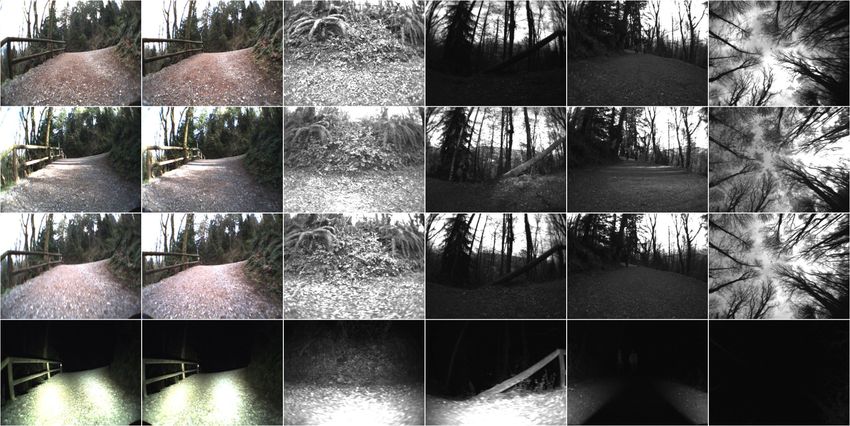
II. ROBOT S ETUP
The configuration of our recording platform is illustrated
in Figure 5:
• 2 × PointGray Firefly color cameras facing forward
in stereo configuration with approximately 90° field
of view (FMVU-03M2C-CS), 752 × 480 pixels, 1/3”
Aptina MT9V022 CMOS, global shutter, 30 Hz
• 4 × PointGray Firefly monochrome cameras facing
port, starboard, rear, and upward with approximately
90° field of view (FMVU-03M2M-CS), 640 × 480
pixels, 1/3” Aptina MT9V022 CMOS, global shutter,
30 Hz
• 1 × SICK LMS111 scanning laser rangefinder with
270° field of view in 0.5° increments, mounted with
180° roll and angled toward the ground in “push-broom”
style approximately 20° to the horizontal, 18m range,
50 Hz
• 1 × SICK LMS200 scanning laser rangefinder with Fig. 2: GPS locations from the dry session, color coded by
180° field of view in 1° increments, sweeping a vertical altitude. The start locations of the two continuous recordings
plane normal to the x-axis of the robot, 8 m range, 10 Hz A and B are labeled on the map. © 2015 Google, Inc.
• 1 × Garmin 18x GPS receiver with 15 m accuracy at
95 % confidence, 5 Hz
• 1 × UM6 inertial measurement unit providing orien- Jungle trail. Recordings were made in four environmental
tation with 2° pitch and roll accuracy and 5° yaw conditions, which we refer to as dry, wet, dusk, and night.
accuracy, angular velocity and linear acceleration, 50 Hz
• Wheel encoders providing linear and angular velocity A. Trail Environments
at 10 Hz Each trail is significantly different in appearance to the
• Barometric pressure sensor from LG Nexus mobile others, as shown in Figure 1. The main features of each are
phone in Pa at 30 Hz described here.
• 4 × Titan 54 W off-road LED lights (ORBT9-54WD- Trans-Canada Trail: densely-forested mountainside ter-
FL) with brightness of 3780 lm, 5000 K color tempera- rain with a gray gravel path approximately 3 m wide. The
ture and 60° beam angle, night sessions only starboard side of the path faces up the slope of the mountain,
All cameras have exposure set to automatic, resulting in and is mostly dirt and small vegetation such as ferns and
large shifts in effective brightness and in the amount of moss, with occasional tree trunks. The port side of the path
motion blur, which is significant in lower lighting. Color faces down the slope, looking out on small vegetation and
cameras are Bayer filtered, resulting in less detailed images dense tall trees, with water and mountains in the distance.
than those from the grayscale cameras. During the night This section of the dataset covers an altitude change of ap-
session, lights are mounted on the base plate below the two proximately 125 m. The Trans-Canada Trail section consists
stereo cameras pointing outward at approximately 10° to the of challenging and self-similar terrain, but distinctive natural
cameras’ optical axes, as well as one light mounted above and artificial landmarks are common.
each side camera pointing in the port or starboard direction, Powerline trail: cleared woodland terrain on a gray and
covered with white tissue paper to improve light diffusion. brown gravel path averaging 3 m wide, with low bushes
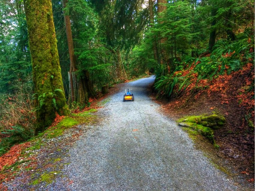
The robot was driven at its maximum speed of 1 m/s for and distant trees on both sides. This trail section includes
most of the dataset, except for rough sections of Jim’s Jungle. powerlines, wooden power poles, and steel powerline towers.
Most of this segment is oriented along the North-South
III. DATASET cardinal axis. The Powerline trail is highly self-similar with
The dataset covers the traversal of three trails from the few unique landmarks, and covers an altitude change of
summit to the base of Burnaby Mountain, with a battery approximately 150 m.
swap break approximately halfway through. We call the first Jim’s Jungle: a section of trail at the base of Burnaby
and second halves of the data part A and part B, the start Mountain with dense tree cover and a narrow brown dirt path
locations of which are marked in Figure 2. Histograms of approximately 1 m wide. This segment has frequent turns,
sensor readings are shown in Figure 4 to summarize and little altitude change, and an uneven trail surface that causes
compare the statistics of the two parts. sharp orientation changes and occasional wheel slippage. On
Part A includes the Trans-Canada Trail and approximately sunny days, shadows and bright patches are more common
half of the Powerline trail, while part B consists of the rest and more severe than in the other sections due to the dense
of the Powerline trail and several hundred meters of Jim’s canopy.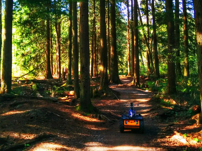
Fig. 3: A sample image from each camera on each session at one of the ground-truth matched locations. Images in each
row belong to the same session; from top to bottom: wet, dry, dusk, night. Cameras from left to right: stereo left, stereo
right, starboard, port, rear, upward.
B. Conditions and provide a set of correspondences between the sessions by
To date, we have recorded four sessions under different timestamp and sets of matching camera images. Envisioned
conditions: uses include evaluating place recognition algorithms on
known place matches, or for establishing known correspon-
• dry—recorded April 19, 2015 on a sunny day in good
dences between localization and/or mapping systems over
weather, with strong shadows and occasional severe the different sessions. Figure 3 shows a single location from
light interference in the camera images. the Trans-Canada Trail recorded by each camera across all
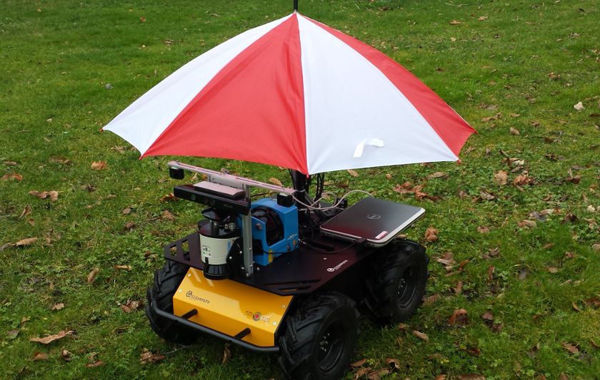
• wet—recorded March 24, 2015 on a rainy day with
four conditions.
overcast skies; shadows mild or nonexistent. The second
half of part A contains a stop to attach an umbrella, D. Sensor Calibration
which protects the vehicle from the rain and obscures We provide spatial transformations for each sensor in the
the upward camera. The rain configuration of the vehicle form of a vector in R6 , which represents x, y, z translation
is shown in Figure 7a. in meters and roll, pitch, yaw in radians with respect to the
• dusk—recorded April 2, 2015 on a dry overcast day robot’s origin as shown in Figure 5. Orientation is applied
just before sunset. The environment has an ambient in the order of roll, then pitch, then yaw with respect to the
brightness of approximately 400 lx at the beginning of fixed axes of the robot’s coordinate frame. For cameras, we
part B, declining to nearly 30 lx by the bottom of the also provide intrinsic calibration in the form of a 3×3 camera
Powerline trail, and is almost zero lux in Jim’s Jungle. matrix and 5-parameter plumb bob distortion model, in the
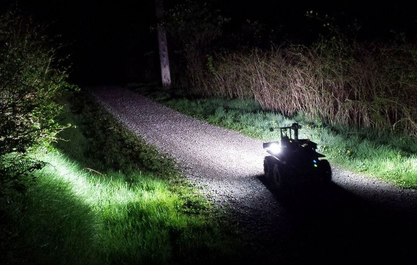
• night—recorded April 20, 2015 in dry weather, long form used by OpenCV.
after sunset. Bright off-road LED lights were mounted We have synchronized sensor timestamps by measuring
on the front and sides of the robot for this session the rate of change of each sensor when the robot starts
to illuminate objects near to the robot, with brightness moving, and aligning the spikes representing this common
dropping off quickly beyond a distance of several me- event to the same time by a fixed offset. The timestamps
ters. Figure 7b shows the vehicle on the Powerline trail of the bag files and in the CSV files already incorporate
at night. this offset, which is given on the web page of the dataset for
reference. The only sensors for which we cannot synchronize
C. Ground Truth Locations timestamps are the GPS and pressure sensors, which are
In addition to the sensor data, we provide 383 ground- fortunately also the least time-sensitive: neither pressure nor
truth location matches between the four sessions: 237 from GPS location are as precise as the other sensors. Timestamps
part A and 146 from part B. These are hand-aligned locations in the CSV files are given in nanoseconds since January 1,
separated by approximately 10 m according to GPS readings, 1970.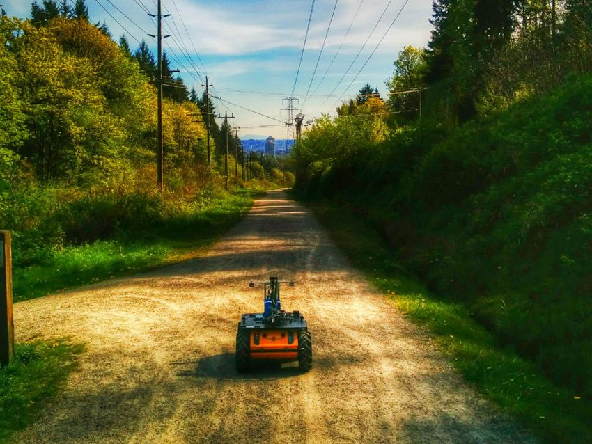
A B A B
yaw (rad) yaw (rad) pitch (rad) pitch (rad)
altitude (m) altitude (m) roll (rad) roll (rad)
pressure (kPa) pressure (kPa) yaw velocity (rad/s) yaw velocity (rad/s)
x velocity (m/s) x velocity (m/s) x acceleration (m/s2 ) x acceleration (m/s2 )
Fig. 4: Histograms of sensor data summarizing and comparing parts A and B of the trail sequence. Each histogram represents
a quantity aggregated over all recording sessions. Pressure readings have a different offset depending on the weather, so we
show the pressure and altitude for only the dry session. Yaw, pitch, roll and acceleration are read from the IMU; altitude
comes from the GPS; pressure is measured by the Nexus phone; linear and angular velocity are given by wheel encoders.
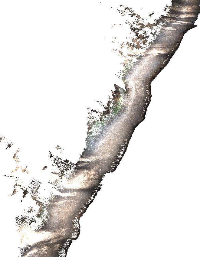
Figure 6 shows readings of the trail surface from the front -.bag. The first line of each CSV file
laser as colored by the stereo cameras, using the intrinsic is a comma-separated header labeling each comma-separated
and extrinsic calibrations provided, and registered according field in the file. Images are bundled by camera and are named
to unfiltered wheel odometry. by their timestamp.
E. Data Format
Data is available in the form of JPEG image files, In general, data are given in raw form except for the
CSV text files and ROS bag files recorded directly timestamp offset. However, we provide GPS locations in both
from the vehicle. Parts A and B of the trail se- (lat, long, alt) and (x, y, z) forms, with the latter given in
quences are available as separate gzipped archive files meters in ENU (East-North-Up) coordinates with origin at
--.tgz and bag files the location of the first GPS location.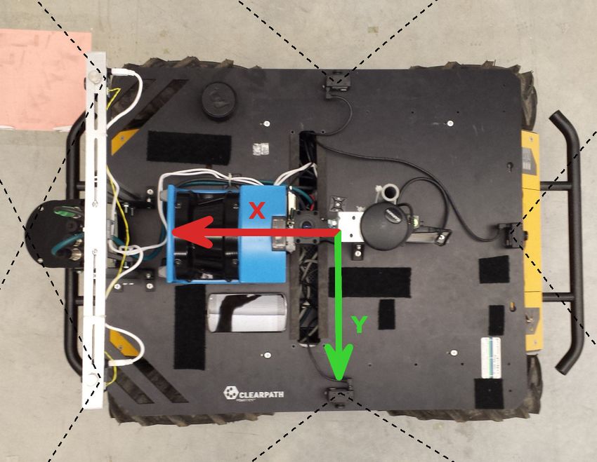
(a) Wet mode

                                                                                            (b) Night mode
Fig. 5: Husky A200 platform used to gather the data in         Fig. 7: Configurations of the robot for two of the environ-
this paper, with arrows indicated the axes of the robot’s      mental conditions in the dataset.
coordinate frame and dotted lines indicating approximate
fields of view of the cameras.
                                                                             IV. S UMMARY AND F UTURE W ORK
                                                                  We have presented a calibrated, synchronized, and ground-
                                                               truth-aligned dataset of woodland trail navigation in semi-
                                                               structured and changing outdoor environments. The data are
                                                               highly challenging by virtue of the self-similarity of the
                                                               natural terrain; the strong variations in lighting conditions,
                                                               vegetation, weather, and traffic; and the three highly different
                                                               trails. In the future we will expand this dataset by record-
                                                               ing more traversals in different conditions. Notable desired
                                                               conditions are mid-summer vegetation growth, autumn leaf
                                                               colors, bare trees in winter, and the rare Burnaby winter
                                                               snow. We also plan to obtain aerial footage of the same trails
                                                               as captured by a UAV following the GPS locations recorded
                                                               by the ground-based robot.
                                                                                      ACKNOWLEDGEMENT
                                                                  Thanks to Jacob Perron, Shokoofeh Pourmehr, Lingkang
                                                               Zhang, and Jack Thomas. This work was supported by
                                                               the Natural Sciences and Engineering Research Council
                                                               (NSERC) through the NSERC Canadian Field Robotics
                                                               Network (NCFRN).
                                                                                           R EFERENCES
                                                               [1] A. Geiger, P. Lenz, C. Stiller, and R. Urtasun, “Vision meets robotics:
                                                                   The KITTI dataset,” Int. J. of Robotics Research, 2013.
                                                               [2] M. Cummins and P. Newman, “FAB-MAP: Probabilistic localization
                                                                   and mapping in the space of appearance,” Int. J. of Robotics Research,
Fig. 6: Trail surface as scanned by the front laser, colored       vol. 27, no. 6, 2008.
                                                               [3] M. J. Milford and G. F. Wyeth, “SeqSLAM: Visual route-based navi-
by projecting into the cameras and registered by unfiltered        gation for sunny summer days and stormy winter nights,” in Int. Conf.
wheel odometry.                                                    on Robotics and Automation (ICRA), IEEE, 2012.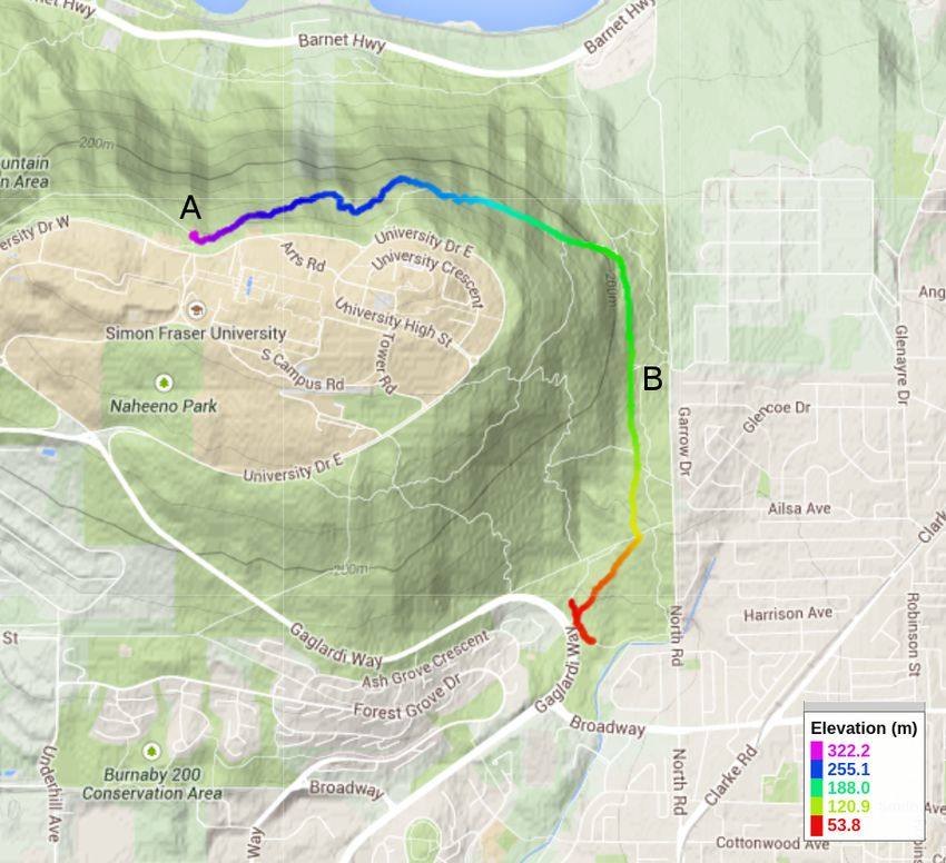

You can also read