The U.S. Tsunami Program: A Brief Overview - Peter Folger Specialist in Energy and Natural Resources Policy
←
→
Page content transcription
If your browser does not render page correctly, please read the page content below
The U.S. Tsunami Program: A Brief Overview

Peter Folger
Specialist in Energy and Natural Resources Policy

March 18, 2015

                                                    Congressional Research Service
                                                                          7-5700
                                                                     www.crs.gov
                                                                           R41686
The U.S. Tsunami Program: A Brief Overview Summary The National Oceanic and Atmospheric Administration’s (NOAA’s) National Weather Service (NWS) manages two tsunami warning centers that monitor, detect, and issue warnings for tsunamis. The NWS operates the Pacific Tsunami Warning Center (PTWC) at Ewa Beach, Hawaii, and the National Tsunami Warning Center (NTWC) at Palmer, Alaska. The tsunami warning centers monitor and evaluate data from seismic networks and determine if a tsunami is likely based on the location, magnitude, and depth of an earthquake. The centers monitor coastal water-level data, typically with tide-level gauges, and data from NOAA’s network of Deep-ocean Assessment and Reporting of Tsunamis (DART) detection buoys to confirm that a tsunami has been generated or to cancel any warnings if no tsunami is detected. As of January 20, 2015, 12 of the United States’ 39 DART buoys were not operational. According to NOAA, the inoperable stations would not prevent the issuance of tsunami warnings, which are primarily a function of seismic data from an earthquake or landslide, combined with location information about the event. However, lacking these stations could mean the warnings encompass a larger area than would be the case if all stations were operating, and it could lengthen the time a warning remains in effect. On January 7, 2015, the House passed by unanimous consent H.R. 34, the Tsunami Warning, Education, and Research Act of 2015. The bill would amend the Tsunami Warning and Education Act (P.L. 109-424) and authorize appropriations for the National Tsunami Hazard Mitigation Program (NTHMP) through FY2017. Authorization for NTHMP appropriations expired in FY2012. On February 23, 2015, the Senate introduced its version of the bill, S. 533, which would authorize appropriations for six years through FY2021. The Senate Committee on Commerce, Science, and Transportation marked up and discharged S. 533 from committee on February 26, 2015. H.R. 34 and S. 533 would not make fundamental changes to the NTHMP, but they would broaden the program to include an increased focus on tsunami research and outreach, among other alterations. The NTHMP assists states in emergency planning and in developing maps of potential coastal inundation for a tsunami of a given intensity. A goal of the program is to ensure adequate advance warning of tsunamis along all U.S. coastal areas and appropriate community response to a tsunami event. The NTHMP formed in 1995 in response to the recognition of a tsunami threat to Oregon, Washington, and Northern California from a large earthquake on the Cascadia subduction zone, which lies off the northwest coast of the United States and is capable of generating earthquakes as large as magnitude 9 or greater. The NTHMP also operates tsunami disaster outreach and education programs through NOAA’s TsunamiReady program. For FY2015, $27 million was appropriated for the NTMHP, which represents “full funding,” according to NOAA. As part of the $27 million total, the House Appropriations Committee report included $6 million in funding above NOAA’s FY2015 request to restore proposed reductions to tsunami grant funds. Key issues for Congress include maintenance and availability of the DART buoy network. P.L. 109-424 states that “maintaining operational tsunami detection equipment is the highest priority within the program carried out under this Act.” H.R. 34 would require that “the Administration’s operational tsunami detection equipment is properly maintained,” but S. 533 would be more specific and require, “to the degree practicable, [the maintenance of] not less than 80 percent of the [DART] buoy array at operational capacity.” Congressional Research Service
The U.S. Tsunami Program: A Brief Overview
Contents
Introduction: U.S. Tsunami Warning Centers .................................................................................. 1
Detecting Tsunamis and Issuing Warnings ................................................................................ 2
The DART Buoy Network ......................................................................................................... 4
The National Tsunami Hazard Mitigation Program ......................................................................... 5
Issues for Congress .......................................................................................................................... 6
Reauthorization of the National Tsunami Hazard Mitigation Program
in the 114th Congress .............................................................................................................. 7
Section 1: Short Title ........................................................................................................... 7
Section 2: Definitions .......................................................................................................... 7
Section 3: Purposes ............................................................................................................. 7
Section 4: Tsunami Forecasting and Warning Program ...................................................... 7
Section 5: National Tsunami Hazard Mitigation Program .................................................. 8
Section 6: Tsunami Research Program ................................................................................ 9
Section 7: Global Tsunami Warning and Mitigation Network .......................................... 10
Section 8: Tsunami Science and Technology Advisory Panel ........................................... 10
Section 9: Report on Implementation of Tsunami Warning and Education Act ................ 10
Section 10: Authorization of Appropriations..................................................................... 11
Section 11: Outreach Responsibilities ............................................................................... 11
Funding for the Tsunami Program ................................................................................................. 12
Figures
Figure 1. Areas of Responsibility for the Pacific Tsunami Warning Center (PTWC) and
the National Tsunami Warning Center (NTWC) .......................................................................... 2
Figure 2. Flow Chart of the Tsunami Warning System .................................................................... 3
Figure 3. Locations of Deep-ocean Assessment and Reporting of Tsunamis
(DART) Buoys .............................................................................................................................. 5
Contacts
Author Contact Information........................................................................................................... 13
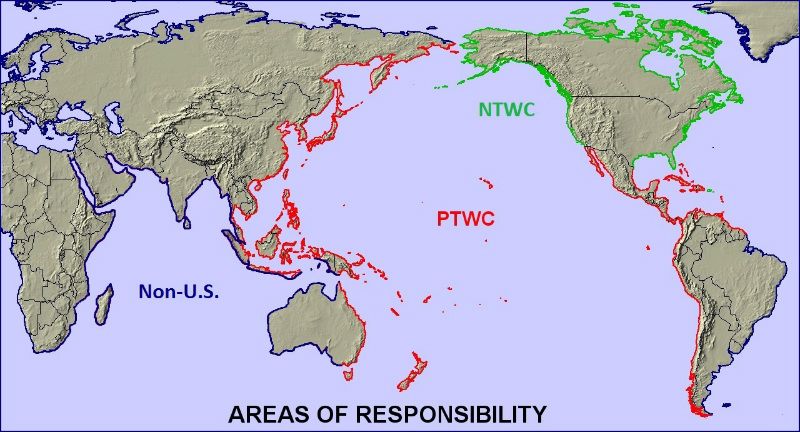
Congressional Research ServiceThe U.S. Tsunami Program: A Brief Overview Introduction: U.S. Tsunami Warning Centers The United States has two centers that monitor, detect, and issue warnings for tsunamis. The National Oceanic and Atmospheric Administration’s (NOAA’s) National Weather Service (NWS) manages both centers. The NWS operates the Pacific Tsunami Warning Center (PTWC) at Ewa Beach, Hawaii, and the National Tsunami Warning Center (NTWC) at Palmer, Alaska. (Before October 1, 2013, the NTWC was known as the West Coast and Alaska Tsunami Warning Center, or WC/AKTWC).1 The PTWC monitors for tsunamis and issues warnings for the Hawaiian Islands, the U.S. Pacific territories, and other U.S. and international interests in the Pacific basin. Following the 2004 Indian Ocean tsunami, the PTWC took on responsibility for monitoring the Indian Ocean, South China Sea, Caribbean Sea, and, temporarily, the U.S. Virgin Islands and Puerto Rico (until June 2007, when responsibility was passed to what was then known as the WC/AKTWC).2 The PTWC was established in 1949 after a strong earthquake and massive landslides off the coast of Southwest Alaska caused a disastrous tsunami that hit the Hawaiian Islands only hours later. The PTWC issued tsunami warnings to Alaska until 1967, when the WC/AKTWC was established. The WC/AKTWC (now the NTWC) was established in the aftermath of the magnitude 9.2 Good Friday earthquake that struck Anchorage, Alaska, in 1964 and caused major earthquake and localized tsunami damage.3 The NTWC is responsible for issuing tsunami warnings to emergency management officials in Alaska, British Columbia (Canada), Washington State, Oregon, and California. In 2007, the NTWC expanded its scope to include the U.S. Atlantic and Gulf of Mexico coasts, Puerto Rico, the U.S. Virgin Islands, and the Atlantic coast of Canada. Figure 1 shows the areas of responsibility for the PTWC and the NTWC. 1 National Oceanic and Atmospheric Administration (NOAA), National Weather Service (NWS), National Tsunami Warning Center (NTWC), “Tsunami Warning Center History,” at http://wcatwc.arh.noaa.gov/?page=history. 2 Ibid. The Pacific Tsunami Warning Center (PTWC) provided interim tsunami warning service from 2005 to 2013 for the Indian Ocean, and it has discontinued that service. Tsunami warning services for the Indian Ocean currently are provided by regional tsunami service providers in Australia, India, and Indonesia. See NOAA, NWS, Pacific Tsunami Warning Center, “PTWC Responsibilities,” at http://ptwc.weather.gov/responsibilities.php. 3 See NOAA, NWS, “TsunamiReady Helps Communities at Risk,” at http://www.tsunamiready.noaa.gov/. Congressional Research Service 1
The U.S. Tsunami Program: A Brief Overview

    Figure 1. Areas of Responsibility for the Pacific Tsunami Warning Center (PTWC)
                   and the National Tsunami Warning Center (NTWC)

     Source: National Oceanic and Atmospheric Administration, National Weather Service, National Tsunami
     Hazard Mitigation Program, at http://nws.weather.gov/nthmp/.

Detecting Tsunamis and Issuing Warnings
The tsunami warning centers monitor and evaluate data from seismic networks and determine if a
tsunami is likely based on the location, magnitude, and depth of an earthquake.4 If a center
determines that a tsunami is likely, it transmits a warning message to NOAA’s weather
forecasting offices and state emergency management centers, as well as to other recipients. The
centers monitor coastal water-level data, typically with tide-level gauges, and data from NOAA’s
network of Deep-ocean Assessment and Reporting of Tsunamis (DART) detection buoys to
confirm that a tsunami has been generated or, if one has not been generated, to cancel any
warnings.5 Figure 2 shows a generalized decision tree network for the earthquake-detection-
through-warning process.

4
  Nearly all tsunamis are triggered by subsea earthquakes, although some may be caused by underwater volcanic
eruptions or landslides.
5
  U.S. Government Accountability Office, U.S. Tsunami Preparedness: NOAA Has Expanded Its Tsunami Programs,
but Improved Planning Could Enhance Effectiveness, GAO-10-490, April 2010, p. 5.

Congressional Research Service                                                                                  2
The U.S. Tsunami Program: A Brief Overview
Figure 2. Flow Chart of the Tsunami Warning System
Source: National Oceanic and Atmospheric Administration (NOAA), How Does the Tsunami Warning System
Work?, http://www.tsunami.noaa.gov/images/warning-system-smaller.jpg. Modified by CRS.
Note: EAS = Emergency Alert System.
Congressional Research Service 3The U.S. Tsunami Program: A Brief Overview The DART Buoy Network NOAA first completed a six-buoy DART array in 2001 in the Pacific Ocean. After the 2004 Indian Ocean earthquake and tsunami that killed more than 200,000 people, Congress passed P.L. 109-424, the Tsunami Warning and Education Act, to enhance and modernize the existing Pacific Tsunami Warning System and broaden coverage, reduce false alarms, and increase the accuracy of forecasts and warnings, among other purposes.6 In part, the 2004 tsunami provided the impetus to expand and upgrade the DART system and to improve the U.S. capability to detect and issue warnings for tsunamis generally. As a result, the DART array was expanded to a total of 39 U.S. DART buoys in March 2008.7 (See Figure 3.) In addition, 8 other countries operate 21 additional DART buoys positioned near faults in the seafloor beneath the Indian and Pacific Oceans, bringing the global total to 60 buoys.8 As of March 18, 2015, 9 of the 39 U.S. buoys (23%) were not operational and were in need of repair. However, P.L. 109-424 requires that NWS ensure that maintaining operations of tsunami detection equipment is the highest priority within the tsunami forecasting and warning program at NOAA. Further, P.L. 109-424 requires the NOAA administrator to notify Congress9 within 30 days of (1) impaired regional forecasting capabilities due to equipment or system failures and (2) significant contractor failures or delays in completing work associated with the tsunami forecasting and warning system.10 According to NOAA, the inoperable stations would not prevent the issuance of tsunami warnings, which are primarily a function of seismic data from an earthquake or landslide, combined with location information about the event. However, lacking these stations could mean the warnings encompass a larger area than would be the case if all stations were operating, and it could lengthen the time a warning remains in effect. NOAA’s current plan is to repair the majority of the stations in spring 2015 and to finish repairing all DART buoys by the end of September 2015.11 6 P.L. 109-424 was signed into law on December 20, 2006. 7 According to NOAA, 33 of the Deep-ocean Assessment and Reporting of Tsunami (DART) buoys are deployed in the Pacific Ocean and the rest are deployed in the Atlantic Ocean and the Caribbean. NOAA, National Data Buoy Center, “Deep-ocean Assessment and Reporting of Tsunamis (DART) Description,” at http://www.ndbc.noaa.gov/dart/ dart.shtml. 8 Personal communication from Mackenzie Tepel, Congressional Affairs Specialist, Office of Legislative and Intergovernmental Affairs, NOAA, January 16, 2015. 9 Specifically, P.L. 109-424 requires the NOAA administrator to notify the Committee on Commerce, Science, and Transportation in the Senate and the Committee on Science (now Science, Space, and Technology) in the House. 10 The statute does not define what is considered impairment of the forecasting abilities or specify a threshold for significant contractor failures or delays. However, the committee report accompanying the bill states that the NWS is required to notify Congress when the tsunami forecasting capabilities are impaired for more than three months; U.S. Congress, House Science, United States Tsunami Warning and Education Act, report to accompany H.R. 1674, 109th Cong., 2nd sess., 2006, H.Rept. 109-698, p. 10. The NWS uses an 80% operational threshold as its internal guideline; telephone conversation with Laura Furgione, Deputy Director, NWS, March 15, 2011. 11 Personal communication from Matthew Borgia, Congressional Liaison for Weather, Office of Legislative and Intergovernmental Affairs, NOAA, January 27, 2015. Congressional Research Service 4
The U.S. Tsunami Program: A Brief Overview

       Figure 3. Locations of Deep-ocean Assessment and Reporting of Tsunamis
                                    (DART) Buoys

     Source: National Oceanic and Atmospheric Administration, National Data Buoy Center, at
     http://www.ndbc.noaa.gov/dart.shtml.
     Note: The United States owns and operates 39 of the world’s 60 DART buoys.

The National Tsunami Hazard Mitigation Program
According to NOAA, the National Tsunami Hazard Mitigation Program (NTHMP) was formed in
response to the recognition of a tsunami threat to Oregon, Washington State, and Northern
California from a large earthquake on the Cascadia subduction zone, which lies off the northwest
coast of the United States and is capable of generating earthquakes as large as magnitude 9 or
greater.12

Among other activities, the NTHMP assists states in emergency planning and in developing maps
of potential coastal inundation for a tsunami of a given intensity. The NTHMP also operates
tsunami disaster outreach and education programs through NOAA’s TsunamiReady13 program.14
NOAA’s primary goals for the NTHMP are as follows:

12
   Ibid.
13
   TsunamiReady is a NOAA/NWS program designed to help cities, towns, counties, universities, and other large sites
in coastal areas reduce the potential for disastrous tsunami-caused damage. See http://www.tsunamiready.noaa.gov/.
14
   NOAA, National Tsunami Hazard Mitigation Program: 2013-2017 Strategic Plan, May 21, 2013, p. 4, at
http://nws.weather.gov/nthmp/documents/NTHMPStrategicPlan.pdf. See also NOAA, NWS, “TsunamiReady Helps
Communities at Risk,” at http://www.tsunamiready.noaa.gov/.

Congressional Research Service                                                                                        5
The U.S. Tsunami Program: A Brief Overview
1. raise awareness of the affected population;
2. develop integrated tsunami maps and recognize models that can be used to
develop improved warning guidance and evacuation maps;
3. improve tsunami warning systems; and
4. incorporate tsunami planning into state and federal multi-hazard programs.15
The Tsunami Warning and Education Act, P.L. 109-424, further focused the NTHMP and
charged NOAA with addressing the nation’s priorities in tsunami detection, warning, and
mitigation. As authorized by P.L. 109-424, the NTHMP assumed responsibility for planning and
executing NOAA’s tsunami activities, namely detection, warning, forecasts, communication,
outreach and education, and research.16 The program coordinates activities among NOAA
organizational entities and outside partners.
Issues for Congress
Maintenance and availability of the DART buoy network have been key issues for Congress. In
its report accompanying the FY2015 Commerce, Justice, Science, and Related Agencies
appropriations bill, the House Appropriations Committee admonished NOAA for failing to
maintain its own 80% availability standard for the network, despite receiving full funding in
FY2014.17 In P.L. 109-424, Congress stated that “maintaining operational tsunami detection
equipment is the highest priority within the program carried out under this Act.” This requirement
also was included in a Senate bill that would have reauthorized the tsunami program in the 113th
Congress, S. 2181.
In the 114th Congress, H.R. 34 , the Tsunami Warning, Education, and Research Act of 2015,
which the House passed by unanimous consent on January 7, 2015, would modify that
requirement somewhat, instead requiring that NOAA “ensure that the Administration’s
operational tsunami detection equipment is properly maintained.” However, H.R. 34 includes
language that would require the NWS to ensure that resources are available to fulfill the
obligations of P.L. 109-424, which presumably would include maintaining the DART buoys. S.
533 is more specific in its language regarding DART buoy maintenance. The legislation would
require, “to the degree practicable, [the maintenance of] not less than 80 percent of the [DART]
buoy array at operational capacity to optimize data reliability.” That requirement matches
NOAA’s internal guideline of 80% as its operational threshold.
Both H.R. 34 and S. 533 would authorize appropriations for the tsunami program of $27 million
per year. However, H.R. 34 would provide a three-year authorization through FY2017, whereas S.
533 would extend the program’s authorization for six years, from FY2016 to FY2021.
15
NOAA, NWS, “About the National Tsunami Hazard Mitigation Program (NTHMP),” at http://nws.weather.gov/
nthmp/about_program.html.
16
Ibid.
17
U.S. Congress, House Committee on Appropriations, Subcommittee on Commerce, Justice, Science, and Related
Agencies, Commerce, Justice, Science, and Related Agencies Appropriations Bill, 2015, 113th Cong., 2nd sess., May 15,
2014, 113-448 (Washington: GPO, 2014), p. 27.
Congressional Research Service 6The U.S. Tsunami Program: A Brief Overview Another issue is whether NOAA is considering a third warning center and on what basis. Currently, the tsunami program includes two warning centers, the NTWC in Alaska and the PTWC in Hawaii. H.R. 34 would authorize the NWS to consider “any additional forecast and warning centers determined by the National Weather Service to be necessary.” It is not clear what the arguments are for siting a warning center in a particular geographic location, given that the DART buoy system and seismometer network are located in the Pacific Ocean, Atlantic Ocean, Caribbean, Gulf of Mexico, and other locations around the globe. However, there may be advantages to siting warning centers in tsunami-prone regions to take advantage of local or regional expertise and experience, and possibly to attract researchers to a particular region to bolster the understanding of the causes and consequences of tsunamis. Reauthorization of the National Tsunami Hazard Mitigation Program in the 114th Congress H.R. 34 and S. 533 would amend the Tsunami Warning and Education Act and authorize appropriations for the NTHMP through FY2017 (H.R. 34) or through FY2021 (S. 533). Authorization for the program’s appropriations in P.L. 109-424 expired in FY2012. Both bills apparently would not make fundamental changes to the NTHMP, but they would broaden the program to include an additional focus on tsunami research and outreach, among other alterations. The following summarizes the changes H.R. 34 and S. 533 would make to P.L. 109-424 on a section-by-section basis, and notes significant differences between the two bills. Section 1: Short Title H.R. 34 and S. 533 would add the term research to the title of the act. Section 2: Definitions P.L. 109-424 defined NOAA and the NOAA administrator. H.R. 34 and S. 533 would omit the section on definitions. Section 3: Purposes H.R. 34 and S. 533 would streamline and update the language in several subsections and add a new subsection (4) that focuses on research as part of the program: “to improve research efforts related to improving tsunami detection, forecasting, warnings, notification, mitigation, resiliency, response, outreach, and recovery.” Section 4: Tsunami Forecasting and Warning Program H.R. 34 and S. 533 are broadly similar throughout Section 4, with some important distinctions. Both bills would streamline and update the language in several subsections. In subsection (b), S. 533 would require that 80% of the DART buoys be maintained at operational capacity. S. 533 also would include a requirement for a cooperative effort among the Administration, the U.S. Geological Survey, and the National Science Foundation under which the agencies’ directors Congressional Research Service 7
The U.S. Tsunami Program: A Brief Overview

would “provide rapid and reliable seismic information ... from international and domestic seismic
networks.” H.R. 34 does not include those provisions.

Both bills would rename subsection (c) the Tsunami Warning System (previously System Areas).
This subsection would require the system to be capable of forecasting tsunamis in the Pacific,
Arctic, and Atlantic Oceans, including the Caribbean Sea and Gulf of Mexico. Subsection (c) also
would require a system that supports other international forecasting and warning efforts.

Subsection 4(d) in H.R. 34 and S. 533 explicitly names the NTWC (formerly the WC/AKTWC),
and includes a requirement that, to the extent practicable, the tsunami warning centers use a range
of models to predict tsunami arrival times and flooding estimates. H.R. 34 would add four new
subsections, 4(d)(3) through 4(d)(6), that would require a fail-safe warning capability, meaning
the two tsunami centers would perform back-up duties for each other. The subsections also would
require the tsunami warning centers to coordinate with the NWS; the NTHMP to develop uniform
operational procedures for both centers; and NOAA to ensure that resources, including
supercomputing resources, are made available to fulfill the obligations of the legislation.

S. 533 contains similar requirements to those in H.R. 34 and adds language focusing on using
data to calculate new inundation estimates, including estimates for ports and harbors at risk of
tsunami inundation, as well as ensuring coordination and data sharing with the Coast Guard.

Both H.R. 34 and S. 533 require coordination with the NWS. The House bill, however, directs the
NWS to coordinate with the tsunami warning centers, whereas the Senate bill requires the NOAA
administrator to coordinate with the NWS, as well as any other program office considered
appropriate. It is unclear whether the different emphasis on who is required to coordinate with
whom would affect the degree of coordination that would ensue. Further, S. 533 calls for the
increased coordination effort to ensure that regional and local forecast offices would implement
mass communication tools, both those in effect and newer tools yet to be developed, so that
tsunami warnings would be delivered in a timely and effective fashion.

Both bills in subsection (e) would omit requirements for a report to Congress regarding
integration of the tsunami warning system with other U.S. observational systems and for a report
to Congress on how technology developed under the tsunami research program is being
transferred to operations.

H.R. 34 further would omit subsections (g) through (k) in Section 4 of P.L. 109-424. S. 533
would omit subsection 4(g), and subsections 4(i) through 4(k) of P.L. 109-424, but it would retain
subsection 4(h), which requires congressional notification in case of impaired forecasting
capabilities due to equipment or system failures. Under subsection 4(h), S. 533 also would require
congressional notification within 90 days of a significant tsunami warning, including brief
information and analysis of the accuracy of the tsunami model used, the monitoring equipment
that detected the tsunami, and the effectiveness of the warnings issued. H.R. 34 does not include
this congressional reporting requirement.

Section 5: National Tsunami Hazard Mitigation Program
Both bills are broadly similar in Section 5. In subsection (a), H.R. 34 and S. 533 both would
require consultation with the Federal Emergency Management Administration and other agencies
that NOAA deems relevant in conducting a community-based tsunami hazard mitigation program

Congressional Research Service                                                                     8
The U.S. Tsunami Program: A Brief Overview

to improve tsunami preparedness and resilience in at-risk areas of the nation. Current law does
not specify that NOAA consult with any particular agency.

The bills would omit subsection (b) of current law, which established a coordinating committee
for the NTHMP,18 and would include expanded and modified requirements for program
components as the new subsection (b). For example, the new subsection 5(b)(1) would require the
NTHMP to provide technical and financial assistance to coastal states, territories, tribes, and local
governments to develop and implement activities under Section 5. Both bills would require
similar activities, under 5(b)(4), to support the development of regional tsunami hazard and risk
assessments. S. 533 also would require evaluations and technical assistance for “vertical
evacuation structure planning for communities where models indicate limited or no ability for
timely evacuation.” In other words, where members of the community would not have time to
move inland before the tsunami struck, they could occupy the “vertical evacuation structures” to
climb above the tsunami wave crest as the wave passed below.

Section 5 of both bills would add a new subsection (c) of authorized activities that the program
may include, such as multidisciplinary vulnerability research, education, and training; risk
management training for local officials and community organizations; development of
applications for existing or emerging technologies; risk management, risk assessment, resilience
data and information services; and risk notification systems.

Section 5 also would include a new subsection 5(d) in H.R. 34 (5(e) in S. 533) that would allow
states to designate at-risk areas in addition to those designated by the federal program based on
knowledge of local conditions.

In addition, Section 5 in both bills would require a report on accreditation of the TsunamiReady
program within 180 days of enactment. The report would indicate which authorities and activities
would be needed to have the TsunamiReady program accredited by the Emergency Management
Accreditation Program.19

Section 6: Tsunami Research Program
H.R. 34 and S. 533 would modify the research program authorized under P.L. 109-424 in
several ways. It would task NOAA with supporting and maintaining the research program in
consultation with other federal agencies, state and territorial governments, academic institutions,
the coordinating committee (established in Section 11 of H.R. 34 and Section 5 of S. 533), and
the scientific advisory committee established in Section 8 (see “Section 8: Tsunami Science and
Technology Advisory Panel”).

Section 6 also would broaden the responsibilities of the research program; for example, the
section specifies that the program shall consider other research to mitigate the impacts of a
tsunami, including the improvement of near-field tsunami detection and forecasting abilities,
which may include use of the Deep-ocean Assessment and Reporting of Tsunamis (DART) buoys

18
   Subsection 11(b) of H.R. 34 would establish the coordinating committee, similar to the one established by P.L. 109-
424 (discussed in more detail below in “Section 11: Outreach Responsibilities”). S. 533 would establish a coordinating
committee under subsection 5(d).
19
   The Emergency Management Accreditation Program (EMAP) is a voluntary standards, assessment, and accreditation
process for disaster preparedness programs in the United States. See http://www.emaponline.org/.

Congressional Research Service                                                                                       9
The U.S. Tsunami Program: A Brief Overview

and NOAA supercomputers. In addition, Section 6 would add a new subsection to require
development of the technical basis for validation of tsunami maps, numerical tsunami models,
digital elevation models, and forecasts.

In H.R. 34, Section 6 also would allow NOAA to launch a pilot project to examine a specific area,
the Cascadia region along the northwest coast of the United States, and develop near-field
tsunami forecasting capability for that region. S. 533 does not contain a similar provision. The
Cascadia subduction zone lies offshore of Washington State, Oregon, and Northern California,
and it has the potential to generate major earthquakes of similar magnitudes to the magnitude 9
Great Sendai Earthquake that struck Japan on March 11, 2011, and generated a devastating
tsunami that killed thousands of Japanese citizens. Forensic evidence has shown that one of the
world’s largest earthquakes occurred along the Cascadia subduction zone in the year 1700,
generated a large tsunami that struck the northwest coast of the United States, and traveled across
the Pacific and damaged coastal villages in Japan.20

Section 7: Global Tsunami Warning and Mitigation Network
H.R. 34 and S. 533 would update the language of this section and require that NOAA coordinate
with the U.S. State Department to provide technical assistance and training to the
Intergovernmental Oceanographic Commission of the United Nations Educational, Scientific, and
Cultural Organization and other international entities.

Section 8 of P.L. 109-424 authorized appropriations for the NTHMP. Section 7 of H.R. 34 and
S. 533 would shift authorization of appropriations to Section 10 in the legislation and add new
sections 8, 9, and 11 (discussed below). Section titles listed below reflect titles in H.R. 34 and
not in existing law.

Section 8: Tsunami Science and Technology Advisory Panel
H.R. 34 and S. 533 would establish a new advisory panel in Section 8 by requiring the NOAA
administrator to “designate an existing working group within the Science Advisory Board of the
Administration to serve as the Tsunami Science and Technology Advisory Panel.” The panel
would advise NOAA on tsunami science, technology, and regional preparedness. The panel would
meet at least once every four years to review the tsunami-related activities of the federal
government and would submit its review findings to NOAA, along with any recommendations.
The NOAA administrator, in turn, would submit the panel’s report to the Senate Committee on
Commerce, Science, and Transportation and the House Committee on Science, Space, and
Technology.

Section 9: Report on Implementation of Tsunami Warning and Education Act
H.R. 34 and S. 533 would require that NOAA submit to Congress a report on progress in
implementing the Tsunami Warning and Education Act with a detailed description of three
sections of the proposed legislation:

20
  U.S. Geological Survey, Earthquakes Hazards Program, Historic Earthquakes-The M9 Cascadia Megathrust
Earthquake of January 26, 1700, http://earthquake.usgs.gov/earthquakes/states/events/1700_01_26.php.

Congressional Research Service                                                                           10
The U.S. Tsunami Program: A Brief Overview

     •    Section 4(d)(6), available resources—requirement that NOAA ensure that
          resources are available to fulfill the obligations in H.R. 34;
     •    Section 5(b)(6), dissemination of guidelines and standards for community
          planning; education; and training products, programs, and tools, including
          standards for mapping products, inundation models, and effective emergency
          exercises; and
     •    Section 6(b)(4), development of the technical basis for validation of tsunami
          maps, numerical tsunami models, and forecasts.
Section 9 also would require that the report to Congress include a description of the ways in
which tsunami warnings and warning products issued by the program can be standardized and
streamlined with warnings for other natural hazards, specifically hurricanes, coastal storms, and
other coastal flooding events.

S. 533 also would require an additional report on national efforts that “support and facilitate rapid
emergency response following a domestic near-shore tsunami event to better understand domestic
effects of earthquake derived tsunami on people, infrastructure, and communities in the United
States.”21 H.R. 34 does not contain a similar provision.

Section 10: Authorization of Appropriations
H.R. 34 would authorize appropriations for the tsunami activities for three years—FY2015
through FY2017—in the amount of $27 million each year. As in current law, the bill specifies that
no less than 27% of the amount appropriated would be for the NTHMP under Section 5 of the bill
and that no less than 8% of the appropriated amount should be for the Tsunami Research Program
under Section 6. S. 533 contains the same formula for allocation of the appropriations but would
authorize the program for six years, from FY2016 to FY2021.

Section 11: Outreach Responsibilities
H.R. 34 and S. 533 would require NOAA to coordinate with state and local emergency managers
to develop and carry out formal outreach activities with the goals of improving tsunami education
and awareness and fostering the development of resilient communities.

Section 11 in H.R. 34 would reauthorize the NOAA administrator to convene a coordinating
committee, originally established under Section 5(b) of P.L. 109-424, that would assist with the
administration of the NTHMP.22 Section 11 would require the committee to have representatives
from each of the states at risk from tsunamis in addition to other representatives that the NOAA
administrator deems appropriate. The coordinating committee would contribute to the program as
follows:

     •    provide feedback on how funds should be prioritized to carry out the NTHMP as
          established by Section 5 of P.L. 109-424 and modified by H.R. 34;

21
   The bill would require that the report include those activities in place on the day before the date of the legislation’s
enactment.
22
   S. 533 would reauthorize the coordinating committee in Section 5.

Congressional Research Service                                                                                                11
The U.S. Tsunami Program: A Brief Overview
• ensure that the areas encompassed by the tsunami warning system in the Pacific,
Arctic, and Atlantic Oceans, Caribbean Sea, and Gulf of Mexico have the
opportunity to participate in the program;
• provide recommendations to the NOAA administrator on how to improve and
advance the TsunamiReady program; and
• ensure that all components of the NTHMP are integrated with state-based hazard
warning, risk management, and resilience activities.
Funding for the Tsunami Program
For FY2015, the Senate Appropriations Committee instructed NOAA to maintain funding at the
FY2014 level for the NTHMP.23 The committee report rejected a proposal from NOAA to
terminate funding for tsunami preparedness within the program. The House Appropriations
Committee instructed NOAA to allocate $27 million for the NTHMP.24 According to NOAA, $27
million represents “full funding” for the program.25 The House report noted that the funding
amount fully supports planned maintenance for the DART buoy network (discussed above) and
that the committee expects NOAA to maintain availability at no fewer than 80% of the stations.
(Currently, fewer than 70% of the stations are operational, as noted above.) In addition, the House
report included instructions to include $6 million above NOAA’s request for FY2015 to restore
Administration-proposed reductions to tsunami grant funds.
Funding for the NOAA tsunami program historically has supported three main categories of
activities: (1) warning, such as the activities of the tsunami warning centers and DART network;
(2) mitigation, such as the activities of the NTHMP; and (3) research, including activities
conducted by the Pacific Marine Environmental Laboratory and the National Buoy Data Center.26
In the NOAA budget, these activities have been cross-cutting among different activities under the
NWS line item. The Government Accountability Office (GAO), which analyzed funding data for
the three general categories in 2010, noted that total funding for all these activities ranged from
$5 million to $10 million annually between FY1997 and FY2004 but increased after the 2004
Indian Ocean tsunami from approximately $27 million in FY2005 to $42 million in FY2009.
According to GAO, the proportion of funding allocated to warning activities increased from about
40% of the total in FY2004 to approximately 70% of the funding in FY2009.27 The proportion
allocated to mitigation decreased from approximately 50% of the total in FY2004 to about 30% in
FY2009, whereas the proportion for research remained steady between about 6% and 10%.
23
U.S. Congress, Senate Committee on Appropriations, Subcommittee on Commerce, Justice, Science, and Related
Agencies, Departments of Commerce and Justice, and Science, and Related Agencies Appropriations Bill, 2015, 113th
Cong., 2nd sess., June 5, 2014, 113-81 (Washington: GPO, 2014), pp. 43-44.
24
Ibid., p. 27.
25
Personal communication from Matthew Borgia, Congressional Liaison for Weather, Office of Legislative and
Intergovernmental Affairs, NOAA, January 27, 2015.
26
U.S. Government Accountability Office, U.S. Tsunami Preparedness: NOAA Has Expanded Its Tsunami Programs,
but Improved Planning Could Enhance Effectiveness, GAO-10-490, April 28, 2010, p. 7.
27
Ibid., p. 8.
Congressional Research Service 12The U.S. Tsunami Program: A Brief Overview Author Contact Information Peter Folger Specialist in Energy and Natural Resources Policy pfolger@crs.loc.gov, 7-1517 Congressional Research Service 13
You can also read