The Use of GNSS in Sweden and the National CORS Network SWEPOS
←
→
Page content transcription
If your browser does not render page correctly, please read the page content below
The Use of GNSS in Sweden and the National CORS Network SWEPOS

             Mikael LILJE, Peter WIKLUND and Gunnar HEDLING, Sweden

Key words: GNSS, CORS, applications, surveying

SUMMARY

Sweden was very early in introducing GPS as an effective tool for navigation, surveying and
mapping. Lantmäteriet, the Swedish mapping, cadastral and land registry authority was one of
the first countries in the world to have a national CORS as well as a nationwide network-
RTK. We realized very early that applications as e.g. cadastral surveying and aerial
photogrammetry would be much more efficient if GPS and a net of permanent GPS stations
could be used. This lead to the establishment of the first stations in early 90’s for applications
that required metre accuracy in real time and centimetre with post-processing. The national
CORS network SWEPOSTM, which last year celebrated 20 years, has been developed since
then and is today a very efficient tool for real time surveying applications that require cm-
accuracies as well as geodynamic research that requires long stable time series. The national
RTK service celebrates 10 years in 2014. Today we have almost 3000 users of network-RTK
in Sweden. The main users can be found at surveying companies and local authorities and the
some of the fastest growing sectors of users are agriculture and machine guidance. The paper
will describe the development of SWEPOS and how GPS, today GNSS, has become such an
important tool for us. One of the main reasons for the success and the many users have been
because the users as well as distributors have been involved in the development of SWEPOS
since many years.

The Use of GNSS in Sweden and the National CORS Network SWEPOS, (7019)                       1/11
Mikael Lilje, Peter Wiklund and Gunnar Hedling (Sweden)                                   The Use

FIG Congress 2014
Engaging the Challenges – Enhancing the Relevance
Kuala Lumpur, Malaysia 16-21 June 2014
The Use of GNSS in Sweden and the National CORS Network SWEPOS

             Mikael LILJE, Peter WIKLUND and Gunnar HEDLING, Sweden

1. INTRODUCTION
The establishment of SWEPOSTM started in the early 90s and it is today a network of more
than 300 permanent GNSS reference stations. The network fulfils a wide range of production
and scientific purposes. The operation, maintenance and development of SWEPOS are
presently the responsibilities of Lantmäteriet (the Swedish Mapping, Cadastral and Land
registration authority). The largest volume of production GNSS measurements in SWEPOS is
carried out with network-RTK technique, which was first introduced in Sweden in 2002.
Regional densification of the original sparse SWEPOS network through successive
establishment projects has since then led to a nation-wide coverage of the network-RTK
service. Today SWEPOS network-RTK almost has 3000 registered users. The users represent
a broad spectrum of disciplines, from cadastral surveying to machine guidance. The rapid
increase of users has also lead to an increasing demand for an around-the-clock availability
and reliability of the positioning services.

The users are of importance in securing that the development of SWEPOS is done to meet
their demand. In recent customer surveys, many users are specifically asking for lower
vertical positioning uncertainty. The results from several studies of network RTK technique,
most notably the “CLOSE” projects (Emardson et al. 2009a and c), have suggested that this
primarily will be achieved by densification of the SWEPOS network. This paper presents the
ongoing efforts of SWEPOS infrastructure modernization, in order to meet user demand as
well as describe some of the user applications. But first we describe Lantmäteriets role in the
Swedish society regarding geodetic activities.

2. LANTMÄTERIET’S GEODETIC ACTIVITIES
2.1 The role of the Department of Geodesy
Lantmäteriet’s Department of Geodesy is a major player in the geodetic field in Sweden. In
addition to the management of the Swedish reference networks, the Department also carries
out comprehensive development, research and support activities including the operation and
development of the SWEPOS reference network. Lantmäteriet is the co-ordinator in Sweden
and also represents Swedish geodesy internationally. Our goals are to provide Swedish society
and other users with

    –   Reference systems that are developed and managed in accordance with international
        praxis and which maintain, over time, a quality that satisfies user needs
    –   A geodetic infrastructure with both active and passive national networks that
        facilitates reliable access to our reference systems
    –   Measures to support an effective use of the geodetic infrastructure, for example in the
        form of method support and the provision of advice
    –   Geodetic observations and knowledge to back up development research and co-
        ordination, both nationally and internationally
The Use of GNSS in Sweden and the National CORS Network SWEPOS, (7019)                      2/11
Mikael Lilje, Peter Wiklund and Gunnar Hedling (Sweden)                                 The Use

FIG Congress 2014
Engaging the Challenges – Enhancing the Relevance
Kuala Lumpur, Malaysia 16-21 June 2014
2.2 Our role as co-ordinator The Swedish government has given Lantmäteriet responsibility for the national co-ordination of geodata. For the Department of Geodesy this implies the role of co-ordinator in the geodetic field. The development of the successful use of the geodetic infrastructure is the fruit of the co-operation between Lantmäteriet’s experts and representatives for other central and local government authorities, private sector companies, colleges of higher education and the universities. In contrast to the situation in many other European countries, Sweden has launched both new reference systems and a national, active reference network, SWEPOS, for the benefit of all users. This has been possible without the need for regulatory legislation thanks to sound co-ordination and co-operation. 2.3 Our international role Geodesy is a global science and its development is influenced by the world around us, which makes international co-operation very important. In Sweden, it is primarily Lantmäteriet and the technical universities that are currently contributing to international development. Lantmäteriet’s Department of Geodesy is engaged in extensive international co-operation. This is carried out directly through official channels, such as by representing Sweden in a number of international organisations. We also co-operate through professional contacts, often organised in professional societies and associations. National and international reference networks are interdependent. The national networks represent the realisation of the international systems which, in turn, require observations from the national systems. This dependence has intensified during the last decade and development continues in a similar direction. The work is based on voluntary participation (own financing) by all of the involved organisations. The international co-operation in which Lantmäteriet’s Department of Geodesy is engaged will, therefore, increase during coming years and, to a great extent, will determine the direction of our activities. Our most important co-operating partners are the International Association of Geodesy (IAG) and its sub-groups in Europe. Currently, IAG’s primary global project is the Global Geodetic Observing System (GGOS). There are also other global and regional organisations in which it is important to actively participate in order to be able to carry out effective geodetic activities in Sweden. Traditionally, co-operation between the Nordic countries has comprised co-ordination of field projects. The ambition is now to change the Nordic Commission for Geodesy (NKG) to be more of a platform on which it will be possible to co-ordinate our resources in several common projects as well as strengthening the role of the Nordic countries in European geodetic co-operation. 2.4 Advice and support Depending on their specific requirements, persons and organisations that carry out practical survey work often require impartial and objective advice concerning choice of measuring techniques and how they should be used. The successful transition to the national reference systems SWEREF 99 and RH 2000 in both the municipalities and government authorities has required a significant input of advice and support. The level of competence in the field survey sector in the municipalities has shown a tendency to decrease at the same time as the new The Use of GNSS in Sweden and the National CORS Network SWEPOS, (7019) 3/11 Mikael Lilje, Peter Wiklund and Gunnar Hedling (Sweden) The Use FIG Congress 2014 Engaging the Challenges – Enhancing the Relevance Kuala Lumpur, Malaysia 16-21 June 2014
techniques have provided great opportunities for simple and cheap solutions with the risk for
uncertain results. Many new players have also appeared on the market.

Lantmäteriet has an important role in Sweden regarding advice and support and we believe,
therefore, that the need for advice and support, in different forms via different media, will be
at least as great during the period up to 2020. An example is the revision of the first version of
the Handbook for Surveying and Mapping (HMK) in which different methods and accuracy
requirements for surveying and mapping are described. The purpose of the handbook is to
contribute to increased conformity and improved quality in surveying and mapping methods
in Sweden.

3. MEASURING WITH GNSS
GNSS techniques can be used for positioning with centimetre accuracy and we are on the way
to replacing an ever increasing part of standard surveying methods. Examples of applications
include large-scale surveys, cadastral surveys, steering of machines in construction projects
and agriculture, positioning different types of underground utilities and the collection of data
for databases containing geodata. During the years up to 2020, new satellite signals in the
existing GPS and GLONASS systems will be taken into use, which will mean that these
systems, by 2020, will each have signals on three frequencies. When Galileo becomes
operational we will have a new satellite system with three frequencies. Also, the development
of the Chinese system Beidou is very interesting to follow and will obviously also be
available for us in Europe.

The introduction of new satellite systems will make satellite techniques even more usable for
positioning in environments where free line of sight to the satellites is restricted, such as in
urban environments with high rise buildings and in forest areas. The combination of new
satellite systems and new satellite signals for GPS and GLONASS will make positioning
quicker and more reliable.

GNSS receivers, combined with MEMS techniques (microelectromechanical systems for
inertial positioning), will enhance possibilities to make measurements with GNSS techniques
without free line of sight to satellites and indoors. The development of MEMS techniques for
use in different fields, such as vehicle crash testing, indoor navigation and positioning of
drilling equipment, is in progress. Another important pre-requisite for an efficient use of
satellite techniques by different user groups is that information regarding the present situation
concerning technology and satellites is made directly available from source in the form of
seminars and user-group meetings.

If Sweden is to retain a leading position as a user of satellite techniques, Lantmäteriet must
continue to actively promote and play a co-ordinating role concerning the development of the
use of GNSS techniques. Furthermore, Lantmäteriet should support the formulation of
standards for positioning in different areas of application and maintain a continuous dialogue
with various user-groups.

The Use of GNSS in Sweden and the National CORS Network SWEPOS, (7019)                       4/11
Mikael Lilje, Peter Wiklund and Gunnar Hedling (Sweden)                                   The Use

FIG Congress 2014
Engaging the Challenges – Enhancing the Relevance
Kuala Lumpur, Malaysia 16-21 June 2014
4. INFRASTRUCTURE FOR GNSS IN SWEDEN
The Swedish geodetic infrastructure for GNSS measurements has been developed in stages to
meet current demands on better positioning uncertainty, reliability and availability from the
user community. At present, the national infrastructure for GNSS measurements comprises
the national network of permanent reference stations, SWEPOS and local user-managed
reference stations. In addition, there is the Swedish Maritime Administration’s DGPS
network, the satellite-based Starfix service from Fugro and the European support system,
EGNOS. SWEPOS is unique in a global perspective as it provides data for both
measurements for production purposes in the form of precision navigation, large-scale
mapping, steering of machinery and for scientific studies of movement in the Earth's crust.

SWEPOS is operated by Lantmäteriet. Currently (spring 2014) the network consists of about
300 stations. The stations are connected to a control centre, which in that way has access to
GNSS data from all stations in real-time.

We found the users of GNSS and SWEPOS services in a broad spectrum of Swedish
organizations as governmental agencies, private companies and universities. The applications
are related to both scientific and production work. Post-processing of GNSS data is mainly
used for scientific work such as studies of crustal motions, meteorology, timing applications,
monitoring GNSS and tasks related to reference systems. Especially the network RTK service
is widely used for data capture in many mapping applications, but also in a lot of other areas,
e.g. cadastral work and within building and construction work (including machine guidance).
The variety of applications that uses network-RTK increases rapidly and currently almost
3000 users are registered to the service.

SWEPOS is under constant development and new technical solutions are regularly
implemented. A good way to verify the benefits from new solutions in SWEPOS and its
services is to let students perform diploma works. Several diploma works have in this way
supported the development of SWEPOS. This also makes the introduction of young surveyors
into the surveying profession easier. They will at the same time bring new knowledge to the
profession and also the capacity to broaden the applications that can be solved by GNSS
measurements.

GPS started to operational for surveying during the 80s. Staff at Lantmäteriet showed early an
interest in the technique and saw the potential to develop efficient surveying in various
applications. In figure 1 we can see a sketch from 1986 showing some ideas on what GPS
could be used for and how to build a system to serve efficient surveying. Please note the idea
on communication between the surveyor and the office and please also recall the technical
situation we had in those days. The idea was developed into a plan where we gave high
priority to the establishment of a national CORS.

The Use of GNSS in Sweden and the National CORS Network SWEPOS, (7019)                    5/11
Mikael Lilje, Peter Wiklund and Gunnar Hedling (Sweden)                                The Use

FIG Congress 2014
Engaging the Challenges – Enhancing the Relevance
Kuala Lumpur, Malaysia 16-21 June 2014
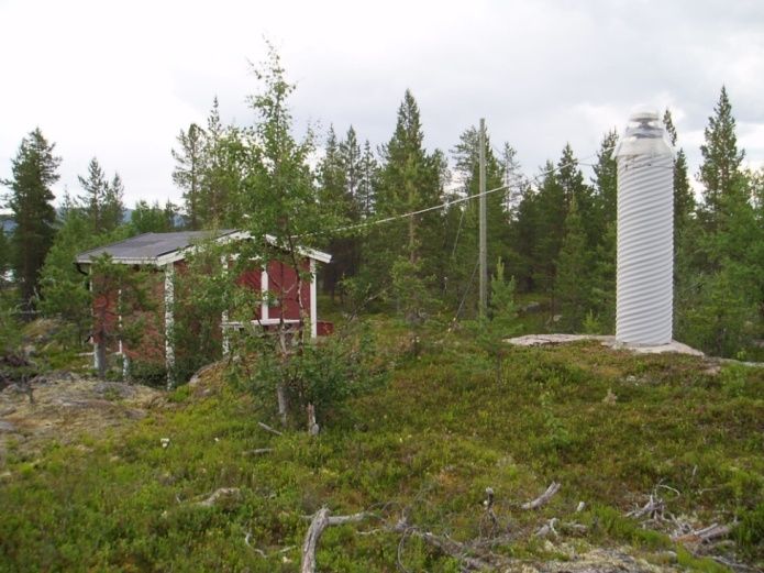
Figure 1. A sketch from 1986 proposing the future cadastral survey

The original SWEPOS network was established in the early 1990s with the first generation of
SWEPOS available in 1993. The CORS network at that time consisted of 21 Class A stations
covering the whole of Sweden with a station separation of about 200 km as well as a control
centre facility at the headquarters of Lantmäteriet. The Class A stations are built on solid
bedrock with a Dorne Margolin antenna installed on a 3 meter high concrete pillar, see
figure 2. Due to winter conditions in Sweden the pillar is heated electrically to hold a constant
temperature of approximately 15o C. The original sparse network of 21 class A stations can be
regarded as the backbone for the present SWEPOS network and realizes the Swedish three-
dimensional reference frame SWEREF 99. We were using RDS for broadcasting corrections
and it was possible for real time applications on the metre level. Also downloading GPS data
for your own post-processing was possible making centimetre applications possible.

In the end of the 90’s, GPS positioning in real time with high accuracy started to become a
reality. Based on the experiences and results that Lantmäteriet gained during several projects
between the years 1999 and 2002, three regional production RTK networks were established.
These were established in co-operation with local partners such as municipalities, private
surveying companies etc. The purpose of these projects was to evaluate network-RTK for
different production applications and to quantify typical rover position uncertainty. These
projects were the start of the second generation of SWEPOS. The establishment of the second
generation really took off in 2002. The SWEPOS Network-RTK service was launched in
2004, starting with the RTK project networks already in place, and extending regionally step-
by-step through similar projects during the next few years. The full-scale densification of the
original sparse SWEPOS network was completed in 2009. The second generation of
SWEPOS lead to the densification of the network to a spacing of 70 km and it was completed
The Use of GNSS in Sweden and the National CORS Network SWEPOS, (7019)                      6/11
Mikael Lilje, Peter Wiklund and Gunnar Hedling (Sweden)                                  The Use

FIG Congress 2014
Engaging the Challenges – Enhancing the Relevance
Kuala Lumpur, Malaysia 16-21 June 2014
by 2009. The bulk of the newly established stations are so called Class B stations (see
figure 3), with less stringent requirements in terms of monument stability and equipment
redundancy. These stations are typically located at public buildings (e.g. municipality offices,
schools and hospitals), with the benefit of faster establishment and easier access.

Figure 2. An original Class A station established in 1993.      Figure 3. A Class B station.

The VRS-concept (Virtual Reference Station) is used. The real-time correction data is
distributed using the RTCM format via two-way GSM/GPRS communication between control
centre and end users. Cooperation with our neighbouring countries is very important to avoid
dublication in building stations. In our network-RTK service we include a number of
Norwegian, Danish and Finnish stations. Users of the service receives positions in the
SWEREF 99 reference frame and can expect a rover position uncertainty (1σ) of 15mm in the
horizontal component and 25mm in the vertical component (i.e. ellipsoid height), given that
recommendations for best practise is followed (e.g. Norin et al., 2006). A high quality geoid
model is also available for those users that require positions in the national height system RH
2000.

5. NETWORK-RTK USERS IN SWEDEN AND THE THIRD GENERATION OF
    SWEPOS
Lantmäteriet has always tried to have a close cooperation with the users. We believe that one
of the reasons to the success of our network-RTK is the fact that we have included the users
early in the process of establishing SWEPOS. The potential users have been involved in e.g.
the regional densification projects that we have when building the second generation of
SWEPOS. In the projects, the users have been able to get familiar with the technique but we
have also had education and user meetings. When the projects ended, the project members in
most cases became a SWEPOS network-RTK user.

It is important to have a close connection with the users. The service is primarily to facilitate
their daily work. We need to understand their expectations and needs and balance that with
what we can accomplish. We organise seminars and user group meetings. We also conduct
questionnaires. Also through several major large-scale construction projects we have
The Use of GNSS in Sweden and the National CORS Network SWEPOS, (7019)                            7/11
Mikael Lilje, Peter Wiklund and Gunnar Hedling (Sweden)                                        The Use

FIG Congress 2014
Engaging the Challenges – Enhancing the Relevance
Kuala Lumpur, Malaysia 16-21 June 2014
understood the expectations from the users. It has been clear that the users request
improvements of vertical position uncertainties in order to fully benefit from the use of
network-RTK, notably for machine guidance and for staking out building elements. The
SWEPOS users also rely on high availability and performance and expect to be notified
immediately in case of operation failures.
Through scientific and empirical studies it was notable that the improved accuracy in vertical
position could be expected through the GNSS modernisation but also through a denser
network. The high availability could be realised through a denser network as well. Therefore,
a decision was made to densify the second generation of SWEPOS to a spacing of around 35
km in larger parts of Sweden and the densification will result in the third generation of
SWEPOS. The current goal is to establish about 40 new reference stations every year. When
new satellite signals become usable for production measurements the uncertainty in height
measurements will be further reduced.
When SWEPOS network-RTK was released 1st of January, 2004 we immediately had about
200 users. They were already part of a regional project described earlier. The number of new
users have been very stable with about 200 new users every year.
The number of users is today around 2300 were the major users comes from local authorities,
surveying consultants and construction enterprises. We see an interesting growth in areas as
machine control and guidance as well as farming.
2500
2000
1500
1000
500
0
2004/01/01
2009/01/01
2014/01/01
Figure 4. The development of SWEPOS network-RTK users since 2004.
If we discuss what sectors where we can find the users it is clear that Lantmäteriet is in
minority when it comes to the number of users even though we have extensive use of the
The Use of GNSS in Sweden and the National CORS Network SWEPOS, (7019) 8/11
Mikael Lilje, Peter Wiklund and Gunnar Hedling (Sweden) The Use
FIG Congress 2014
Engaging the Challenges – Enhancing the Relevance
Kuala Lumpur, Malaysia 16-21 June 2014technique in cadastral survey. From the beginning we found many of the users in minor
surveying consultants, municipalities and governmental authorities but it soon was clear the
surveying consultants, no matter of size, saw positive effects in using network-RTK. We are
using GPRS as communication link between the user and the control centre. We still have
areas in Sweden where GPRS-coverage is not available. We have also noticed in major cities
that there are limitations in the access of 3G since so many people nowadays are using smart
phones and tablets. Therefore several of the major surveying consultants use or consider radio
communication to be more efficient and give that priority instead of network-RTK compared
to single station RTK. But it is clear that RTK (or network-RTK) is very interesting for
machine control and guidance. Recently we have noticed that more and more of the new users
can be found in machine control and guidance as well as farming. A medium sized farm in
Sweden notice that there is a turnaround of the investment in RTK-equipment in say 3-4 four
years. The biggest effect is in lower fuel consumption but also larger harvest is an important
effect. We have had several successful co-operations with the Swedish Transport
Administration where they have used a densified SWEPOS in major infrastructure projects. In
figure 5 we can see a distribution between several categories
Municipalities
Surveying consultants
Lantmäteriet
Construction enterprises
Farming
Electricity suppliers
Governmental authorities
Others
Demo
Figure 5. Distribution between different user categories of SWEPOS network-RTK
SWEPOS network-RTK used to be the only network-RTK service with national coverage.
Cooperation started with Trimble VRS Now started a few years ago where we are using the
same GNSS infrastructure (SWEPOS) but providing two services. It has been our aim that we
should use the same infrastructure to ensure that the result for the users will be in the national
reference systems as well as we believe that this model would be the most cost-effective for
us as a country. Currently also Leica SmartNet Sweden and Topcon TopNet live also offer
national network-RTK services, based on the same GNSS infrastructure. We find this solution
very efficient and has noticed that we are not competing about the users as could be expected
The Use of GNSS in Sweden and the National CORS Network SWEPOS, (7019) 9/11
Mikael Lilje, Peter Wiklund and Gunnar Hedling (Sweden) The Use
FIG Congress 2014
Engaging the Challenges – Enhancing the Relevance
Kuala Lumpur, Malaysia 16-21 June 2014but more supplement each other. From our perspective, we do not have access and knowledge with e.g. the sectors that are growing quickest, i.e. farming and machine control and guidance. However, our partners do! We have also noticed that the cooperation does not mean that we have fewer new users. We can still expect some 200 new users every year. REFERENCES Emardson R, Jarlemark P, Bergstrand S, Nilsson T, and Johansson J, (2009): Measurement Accuracy in Network-RTK. SP report 2009:23, ISBN 978-91-86319-10-6, SP Technical Research Institute of Sweden, Borås. Emardson R, Jarlemark P, Johansson J, Bergstrand S, Lidberg M, and Jonsson B, (2009): Measurement Accuracy in Network-RTK. Submitted to: Bulletin of Geodesy and Geomatics, Special issue from the EUREF Symposium in Florence, May 2009. Emardson R, Jarlemark P, Bergstrand S and Johansson J, (2011): Ionospheric Effects on Network-RTK. SP report 2011, SP Technical Research Institute of Sweden, Borås Engberg, L. E., Lilje, M (2011): Strategic Plan for Geodesy in Sweden, FIG WW Marrakesh, Marocco, 2011 Geodesy 2010 – a Strategic Plan for Geodesy in Sweden, www.lantmateriet.se, Lantmäteriet, 2011 Jonsson B, Wiklund P (2014): SWEPOS - 20 år utveckling av GNSS-tekniken, SINUS 2014:1 (In Swedish) Norin D, Engfeldt A, Öberg S, Jämtnäs L (2006): Short manual for surveying with SWEPOS Network RTK service. Rapportserie: Geodesi och Geografiska informationssystem 2006:2, Lantmäteriet, Gävle. (In Swedish) Sunna J, Jämtnäs L, Jonsson B (2010): Improving RTK positioning with SWEPOS™ – lessons from theory and practice. NKG, 16th General Assembly, September 27–30 2010, Sundvollen, Norway. The Use of GNSS in Sweden and the National CORS Network SWEPOS, (7019) 10/11 Mikael Lilje, Peter Wiklund and Gunnar Hedling (Sweden) FIG Congress 2014 Engaging the Challenges – Enhancing the Relevance Kuala Lumpur, Malaysia 16-21 June 2014
BIOGRAPHICAL NOTES

Mr. Mikael Lilje
Mr Lilje is the Head of the Geodetic Research Department at Lantmäteriet (the Swedish
mapping, cadastral and land registration authority). He graduated with a M.Sc. with emphasis
on geodesy and photogrammetry from the Royal Institute of Technology (Stockholm,
Sweden) in 1993. He has been working at Lantmäteriet since 1994, mainly at the Geodetic
Research Department. Mikael is the chair of FIG Commission 5 between 2011-14 and has
been involved in FIG since 1998.

CONTACTS

Mikael Lilje
Geodetic Research Department
Lantmäteriet
SE- 801 82 Gävle
SWEDEN
Tel. +46 26 63 37 42
Fax +46 26 61 06 76
Email: mikael.lilje@lm.se
Web site: http//www.lantmateriet.se

The Use of GNSS in Sweden and the National CORS Network SWEPOS, (7019)                 11/11
Mikael Lilje, Peter Wiklund and Gunnar Hedling (Sweden)

FIG Congress 2014
Engaging the Challenges – Enhancing the Relevance
Kuala Lumpur, Malaysia 16-21 June 2014
You can also read