Towards an urban land reform in Madagascar? - Madagascar Support to Madagascar Urban Land Policy
←
→
Page content transcription
If your browser does not render page correctly, please read the page content below
Public Disclosure Authorized
Report No: AUS0001545
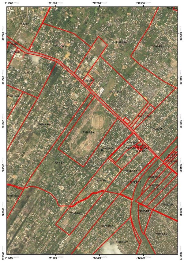
.
Public Disclosure Authorized
Madagascar
Support to Madagascar Urban Land Policy
Towards an urban land reform in Madagascar?
.
Public Disclosure Authorized
June 15, 2020
.
URS
Public Disclosure Authorized
.
1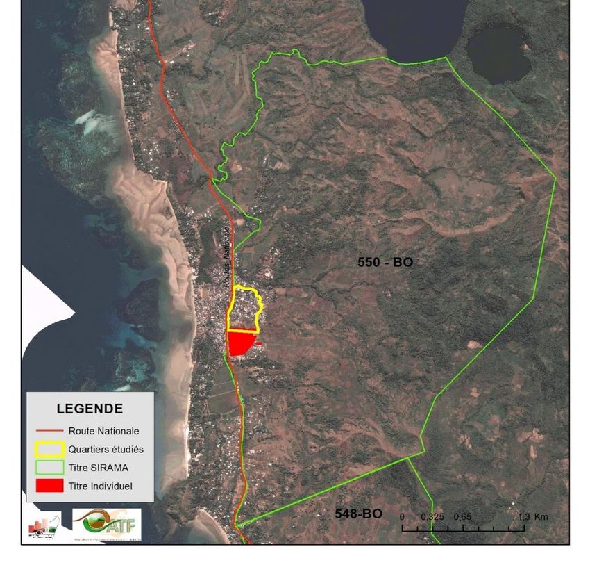
.
© 2017 The World Bank
1818 H Street NW, Washington DC 20433
Telephone: 202-473-1000; Internet: www.worldbank.org

Some rights reserved
This work is a product of the staff of The World Bank. The findings, interpretations, and conclusions expressed in this
work do not necessarily reflect the views of the Executive Directors of The World Bank or the governments they
represent. The World Bank does not guarantee the accuracy of the data included in this work. The boundaries, colors,
denominations, and other information shown on any map in this work do not imply any judgment on the part of The
World Bank concerning the legal status of any territory or the endorsement or acceptance of such boundaries.

Rights and Permissions. The material in this work is subject to copyright. Because The World Bank encourages
dissemination of its knowledge, this work may be reproduced, in whole or in part, for noncommercial purposes as long
as full attribution to this work is given.

Attribution—Please cite the work as follows: “World Bank, 2020. Towards an Urban Land Reform in Madagascar? © World
Bank.”

All queries on rights and licenses, including subsidiary rights, should be addressed to World Bank Publications, The
World Bank Group, 1818 H Street NW, Washington, DC 20433, USA; fax: 202-522-2625; e-mail:
pubrights@worldbank.org.

                                                     2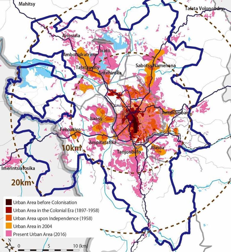
Towards an urban land reform in
                                      Madagascar?

 Volume 1: Review of the urban land sector and initial recommendations
                                     to improve urban land governance

Support for Urban Land Policy in Madagascar
Advisory Services and Analytics
May 2020

                                              3
ACKNOWLEDGEMENTS
This document was prepared on the basis of three initial reports developed by three different teams:
(i)      “Assessment of urban land use in Antananarivo” by the Malagasy Land and Land Use Planning
         Observatory (Andrianirina Harifidy, Burnod Perrine, Rabeantoandro Rado, Nokoloina
         Manevasoa Ny Anjara, Rajaonarivelo Eli Olivier, Ravelo Arsène, Rakoto Andrianjafy Malala,
         Rakotoarimalala Vonjy, Ravelojaona and Miharisoa Linda), supported by the Integrated Urban
         Development and Resilience Project (PRODUIR);
(ii)     “Assessment of urban land use in Nosy Be” by a joint team from the Malagasy Land and Land Use
         Planning Observatory and the Environmental Management Support Service, with the support of
         the Integrated Growth Pole (PIC); and
(iii)    An intermediate working document on “urban land management in Antananarivo: assessment and
         strategic options” by Alain Durand Lasserve.
The final report was produced by a team from the World Bank consisting of Rivo Andrianirina-
Ratsialonana, Gaël Raserijaona, Aanchal Anand and André Teyssier.
This analytical work on urban land use and issues owes a lot to Coralie Gevers, Marie-Chantal
Uwanyiligira, Mark Lundell and Raymond Bourdeaux, and the work’s development widely benefitted from
their guidance and support. In addition, the team was also able to take advantage of the considerable
support of other projects financed by the World Bank, especially PRODUIR and PIC, through the
involvement of Eneida Fernandes, Michel Matera, Eric Rakoto Andriatsialavo, Toky Rakotonandrasana,
Tsiong Ho Tu Ken and Jacky Ralaiarivony. The team is also grateful to the GIZ for the availability of
Marguerite Duponchel during the design phase and that of the GIZ teams that contributed information
about local taxation.
The team extends its heartfelt thanks to the Malagasy Ministry of Land Management, Housing and Public
Works (Ministère de l’Aménagement du Territoire, de l’Habitat et des Travaux Publics), and first and
foremost, SEM, for their availability, the Minister Hajo Andrianainarivelo, the General Secretary
Bebiarivola Rakoto, Tantely Ravelojaona and her team at the FNF, Petera Ratolorantsoa, Rabe
Harimanana, the directors and the entire team of the MATP at the central level and in the land services of
the cities of Antananarivo and Nosy Be. The team is also grateful to the Secretary General and the team
of the urban municipality of Antananarivo, the mayor and his co-workers of the urban municipality of Nosy
Be. Moreover, we would like to sincerely thank the different partners for their valuable contributions: the
NGOs ENDA, Habaka and Hardi, the platform of civil society organizations SIF, GIZ, AGETIPA, the Immo
Conseil Mada agency, the Order of Notaries of Madagascar and the heads of the fokontany of the areas
visited.
Dina Ranarifidy, Camille Bourguignon and Hajarivony Andriamarofara reviewed the interim version of
the report that was greatly enriched thanks to the contributions of the World Bank team on land issues,
coordinated by Jorge Munoz.
The team especially appreciated the support of Josiane Rarivoson, Gabriela Itzel Nunez, Lucas Bochud
and Ndolassem Christabelle Mbairo who greatly facilitated the production of this study through their
assistance with the supplementary translation and the various logistical aspects.
The English translation of this document was produced by Gail Wagman.

Disclaimer: This analytical work is a product of the staff of the International Bank for Reconstruction and Development
(the World Bank) of the World Bank Group. The findings, interpretations, and conclusions expressed here do not
necessarily reflect the views of the Executive Directors of the World Bank or the governments that they represent. The
World Bank does not guarantee the accuracy of the data in this work .

                                                          4
TABLE OF CONTENTS
ACKNOWLEDGEMENTS ........................................................................................................................................4
TABLE OF CONTENTS ............................................................................................................................................5
LIST OF ACRONYMS ...............................................................................................................................................6
EXECUTIVE SUMMARY .........................................................................................................................................7
INTRODUCTION ..................................................................................................................................................... 22
   URBAN LAND GOVERNANCE, FORGOTTEN BY THE LAND REFORM ............................................................................ 22
   STUDY OBJECTIVES .................................................................................................................................................. 24
   PRESENTATION OF THE METHOD AND CAVEAT ......................................................................................................... 25
     Phase 1: Overview of urban land governance and initial recommendations ..................................................... 25
     Caveat: phases 2 and 3 could not be carried out ................................................................................................ 25
SECTION 1 – OVERVIEW OF URBAN LAND GOVERNANCE ...................................................................... 26
   ANTANANARIVO – LAND SATURATION AND INFORMAL RIGHTS ............................................................................... 27
     Strong demographic growth faced with the scarcity of available land ............................................................... 27
     Densification of the built environment: social and economic rationales ............................................................ 28
     Urban expansion often precedes urban development plans ................................................................................ 29
     Inheritance and purchase, the principle ways of acquiring land ........................................................................ 30
     The gap between land information and actual land occupancy .......................................................................... 31
     Feeling of insecurity and land disputes .............................................................................................................. 34
     An inadequate administrative capacity for the efficient management of urban land .......................................... 35
   NOSY BE – LAND COMPETITION BETWEEN TOURISM, AGRICULTURE AND URBAN EXPANSION ................................. 36
     A sugar-producing island faced with strong urban growth ................................................................................ 36
     The land heritage of SIRAMA cannot resist urban growth ................................................................................. 38
SECTION 2 – THE ECONOMIC AND SOCIAL CONSEQUENCES OF INADEQUATE LAND
INFORMATION ....................................................................................................................................................... 40
       Social and family tensions .................................................................................................................................. 40
       Unreliable land information slows down and raises the cost of investments in urban infrastructures .............. 40
       Lack of updated land data hampers the collection of tax revenues .................................................................... 41
SECTION 3 – PROPOSALS FOR POLICY OPTIONS TO IMPROVE URBAN LAND GOVERNANCE .... 43
   DEVELOPING A STRATEGY ADJUSTED TO THE CONSTRAINTS AND TO THE CONTEXT ................................................. 43
   RECOMMENDATIONS FOR THE EFFICIENT MANAGEMENT OF URBAN LAND ............................................................... 44
     Step 1: To update land information via a systematic assessment and the development of urban PLOFs (Local
     Land Occupancy Plans) ...................................................................................................................................... 45
     Step 2: To formalize and secure occupancy through the use of innovative tools ................................................ 47
     Should an agency responsible for the coordination and implementation of urban land operations be created?
      ............................................................................................................................................................................ 51
     Summary and sequence of proposals for a dialogue for efficient urban land administration and management 52
     General Strategies for Urban Land Generation ................................................................................................. 55
     Strategy 1: Developing a method for upgrading and securing land tenure in slums .......................................... 55
     Implementing a full-scale urban land management laboratory within the PRODUIR framework ..................... 57
     Strategy 2: To increase and diversify the land supply in order to improve its affordability ............................... 58
     Strategy 3: Promote the low-income rental sector as a solution to the problem of high-risk occupancies ........ 60
   LAND REGULARIZATION IN NOSY BE: WHAT ARE THE POSSIBILITIES? ..................................................................... 61
     Relaunch the dialogue on land policies .............................................................................................................. 62
BIBLIOGRAPHY ...................................................................................................................................................... 64
APPENDICES............................................................................................................................................................ 67

                                                                                        5
List of Acronyms
AGEREF      Agence de Gestion des Réserves Foncières / Land Reserve Management Agency
AGETIPA     Agence d’Exécution des Travaux d’Intérêt Public et d’Aménagement
ASA         Advisory Services and Analytics
AUGA        Agence d’Urbanisme du Grand Antananarivo / Urban Development Agency of Greater
            Antananarivo
CF          Certificat foncier / Land certificate
CUA         Commune Urbaine d’Antananarivo / Urban Municipality of Antananarivo
CUNB        Commune Urbaine de Nosy Be / Urban Municipality of Nosy Be
DDPF        Direction des Domaines et de la Propriété Foncière
DE          Droit d’enregistrement / Registration right
DETT        Direction des Etudes et Travaux Topographiques
DGAT        Direction Générale de l’Aménagement et de l’Habitat
DGSF        Direction Générale des Services Fonciers
DMR - CUA   Direction de la Mobilisation des Ressources
FNF         Fonds National Foncier / National Land Fund
GF          Guichet Foncier / Municipal Land Office
IFPB        Impôt Foncier sur les Propriétés Bâties / Property taxes on building property
INSTAT      Institut National de la Statistique
LPF          Lettre de Politique Foncière / Land Policy Letter
MATP        Ministère de l’Aménagement du Territoire et des Travaux Publics
PGDI        Projet d’appui à la Gouvernance et au Développement Institutionnel
PLOF        Plan Local d’Occupation Foncière / Local Land Occupancy Plan
PNDU        Politique Nationale de Développement Urbain / National Urban Development Policy
PUDi        Plan d’Urbanisme Directeur / Master Urban Development Plan
PUDé        Plan d’Urbanisme de Détail / Detailed Urban Development Plan
PRODUIR     Projet de Développement Urbain Intégré et Résilience du Grand Antananarivo /
            Integrated Urban Development and Resilience Project of Greater Antananarivo
OATF        Observatoire de l’Aménagement du Territoire et du Foncier
SRAT        Service Régional d’Aménagement du Territoire / Regional Land-Use Planning Service
SEIMAD      Société d’Equipement Immobilier de Madagascar
TATOM       Projet d’extension de l’axe Antananarivo – Toamasina
TF          Titre Foncier / Land title
ZAC         Zone d’Aménagement Concerté / Joint Development Zone

                                             6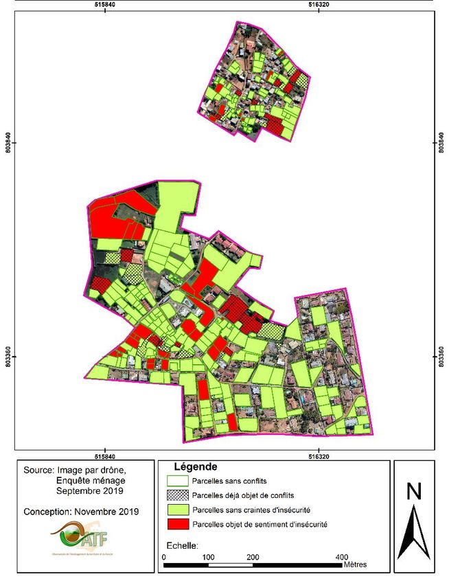
Executive Summary
Introduction
1. Urban land governance, forgotten by the reform of 2005. The land reform initiated by the Government
   of Madagascar in 2005 was focused on the decentralization of land management in rural areas. The
   solutions implemented could not be applied in urban areas where the question of land security is not
   linked to the lack of documentation but, instead, to the existence of out-of-date land documents,
   generally with no relationship to actual land occupancy. Land titles often represent a land situation that
   existed in the past and no longer correspond to the formats or to the occupants of the property, making
   it difficult and often impossible to know who has the right to which property, to collect taxes, and to
   develop urban planning policies. Moreover, the lack of reliable land information is a threat to social
   cohesion because of the many conflicts within families, between neighbors and with public institutions.
   This weak land tenure raises serious problems in the cities that are undergoing exponential demographic
   growth and that are deprived of the basic information necessary for their development. An urban land
   reform is seriously lacking in Madagascar.
2. Study objectives. The purpose of this study is to propose strategic options to improve urban land tenure
   management. Insofar as the urban land sector is poorly documented, it is first necessary to carry out an
   assessment of land governance in two urban municipalities, Antananarivo and Nosy-Be. The aim of
   this assessment is to: (i) describe land management systems in the city; (ii) reveal the extent of the gap
   between the reality of land occupancy and the land information recorded by the administration; and (iii)
   explain the reasons behind them. On the basis of this information, this study presents a series of
   recommendations and draws attention to international practices that could help to guide the
   development of a strategy to improve urban land governance in Madagascar. In the longer term, this
   study can be considered as the starting point for a dialogue between the Government, land sector
   stakeholders, the World Bank and other partners for the design of a large-scale intervention to address
   rural and urban land tenure in its entirety, complementing the experiences gained to secure rural land
   tenure and the initiatives already in place to secure urban land tenure.
3. Presentation of the method and caveat. This study was initially broken down into three phases: (i) an
   assessment of urban land governance in Antananarivo and Nosy-Be, accompanied by an initial list of
   possible recommendations, developed in partnership with the OATF, two projects financed by the
   World Bank (PIC and PRODUIR) and an international expert; (ii) discussions with the main
   stakeholders in the sector; and (iii) the design of an urban development land tenure strategy in
   conjunction with teams from the Government. The current health crisis linked to COVID-19 led to the
   postponement of discussions on possible solutions. The missions and workshops planned in Morocco
   and in Madagascar in March and April 2020 were cancelled as well. This document is therefore an
   intermediary document drawn up by the World Bank, whose assessment and recommendations
   have not yet been discussed with the government or with the other stakeholders in the sector.
   Consequently, this document is to be considered as a basis for proposals in view of future
   discussions when sanitary conditions permit.
4. COVID-19 Response and Recovery. While it was not the initial objective of this study, one need that
   has emerged in the past few months is need for a swift response against crises like COVID and the
   proper policy tools and infrastructure investments for economic recovery. Urban land governance has
   a central role to play in both resilience and recovery in four major ways. First, land tenure security is
   critical to ensuring the protection of people’s shelter, physical security, and livelihoods. Without some
   kind of regularization, the urban poor may not even have a safe place where they can ‘stay at home’ to
   practice ‘social distancing.’ Second, land administration investments, including land information
   systems and geospatial data, can help identify the poor for targeted interventions and to do predictive

                                                     7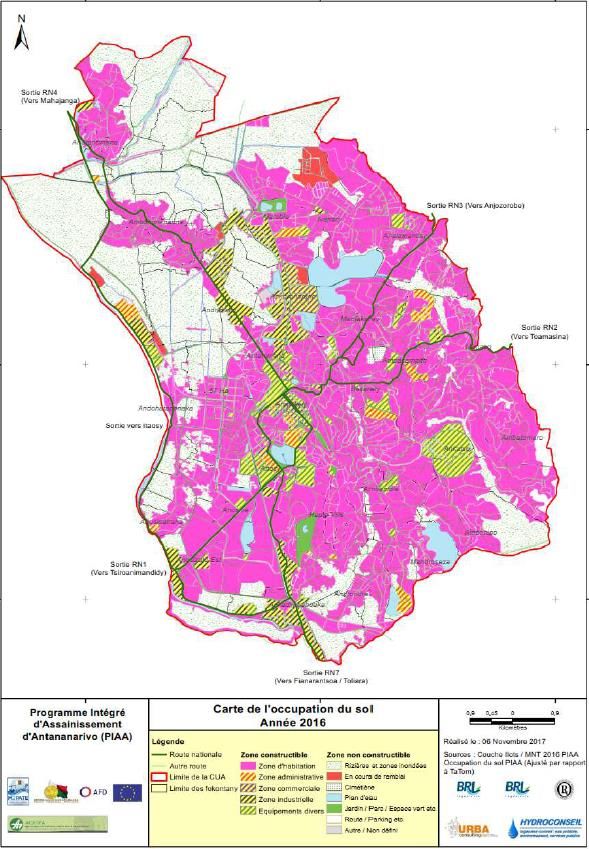
analysis so that hotspots can be foreseen and a more effective response can be developed. Third, making
     land information system interoperable with social databases can help make COVID response more
     effective. Fourth, economic recovery will require a push for infrastructure investments (roads, housing
     etc.), many of which can be made easier and cheaper through investments in systems and practices that
     document land ownership and occupancy.

Section 1 – Overview of Urban Land Governance

Antananarivo – land saturation and informal rights
5. Strong demographic growth faced with the scarcity of available land. The population of Antananarivo
   has one of the highest growth rates in Africa (3.6%). Some 50,000 to 60,000 households that have
   abandoned farming arrive in the capital each year. In 2019, the Urban Municipality of Antananarivo
   (CUA) counted almost 2 million inhabitants1 for an area of 88 km2, resulting in a density of 22,000
   inhabitants per km2. With its 26 peripheral municipalities, the agglomeration is home to some 3 million
   inhabitants. Between 2003 and 2017, the urban footprint increased from 25 to 33 km². The city extends
   from the central hills towards the surrounding flood plains, often through filled-in rice paddies. In fact,
   in the past, social structuring determined the urban landscape: basically, the wealthy noble families
   lived at the top of the hills and their sharecroppers cultivated their rice paddies below in the flood plains.
   These rice paddies, often titled, were filled in as the city continued its remarkable expansion, and
   became known as the “bas-quartiers” (or slums). Poor families that lived on the rice-growing plain
   often remained there and expanded, progressively evolving from sharecropping to different urban
   trades. The scarcity of available land linked to a context of extreme poverty led to the development of
   slums and precarious housing that is home to 72% of the urban population. It is one of the forces driving
   urban sprawl into areas particularly unsuitable for residential housing. Successive planning initiatives
   are no longer sufficient to manage this accelerated urban development. The spaces that can still be
   developed are in the process of being absorbed at this time.
6. Inheritance and purchase are the principle ways of acquiring urban land. Inheritance concerns 50%
   of the land and corresponds to a patrimonial logic. Inherited land is rarely put on the market and is
   primarily intended to house the family. Inheritance remains the main vector to access land and housing
   for the poorest. The land market is largely active but generally subsists outside of official networks.
   The majority of sales take place directly between relatives or friends (95%), and only a minority through
   unofficial intermediaries. The poorest elements of the population have no access to the land market,
   even the unofficial one. They must settle for illegal occupancies where they first install a makeshift
   shelter, and then, if there is no objection, build a sturdier dwelling. Rentals are widespread but poorly
   documented. The number of men and women who are owners or beneficiaries is similar because land
   remains within the family circle and the rules for transferring real estate on the Hautes Terres are not
   discriminatory.
7. Official land information rarely corresponds to the actual land occupancy. Three quarters of the
   official land documents do not correspond to the current land occupants. In 2019, 88% of the parcels
   were already registered, but few of these registrations were updated. Some 80 to 90% of the land has
   undergone cadastral operations since 1939, but they have rarely been finalized with the issuance of a
   land title. A total of 53% of the land is titled. On this titled land, only 25% of the parcels are registered
   in the name of the current owners; the others are not updated and are registered in the name of a relative
   or former owner. A total of 32% of the titled landowners have no title of their own. Once the title is
   obtained, the transactions are rarely registered. Only 12% of the occupants of a titled property have

1 Unofficial but likely estimate, established on the basis of several sources (World Bank, 2011; UN-Habitat, 2012; official site of
the CUA http://www.mairie-antananarivo.mg/. The official figures of the last General Population and Housing Census reported a
total of 1.2 million inhabitants for the CUA. This gap could be attributed to issues concerning the methodology and the geographic
boundaries of the CUA.

                                                                                                                                 8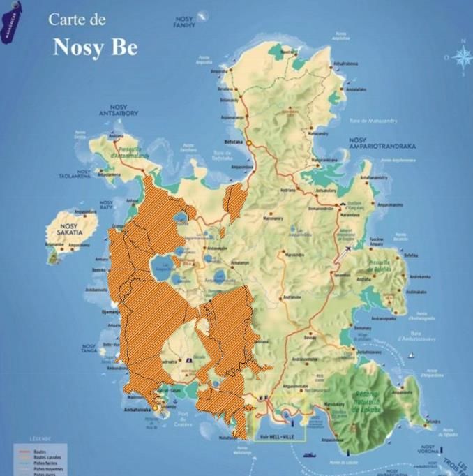
undertaken the measures necessary to officially register a sale or inheritance. Some 50% of the
      applications undergoing registration are more than 5 years old and 28% are more than 15 years old.
      This low rate of registration can be explained by the cumbersome procedures because the property has
      often passed through the hands of several owners without ever being updated. It is, therefore, necessary
      to reconstitute the entire chain of transactions by recreating all of the successive administrative and
      legal documents, and to pay the different costs. Moreover, the limits of the parcels legally registered
      no longer correspond to the current parcel boundaries. The parcels were subdivided and often have
      nothing to do with those on the cadastral map. To materialize and protect their rights, households
      especially use physical markings (walls, fences, buildings etc.).
8.    Three-quarters of the households use “small papers” to invoke their land rights. For want of an
      official property document established in their name, 74% of the occupants resort to different
      documents of varying degrees of legality to secure their rights. Some 95% of the purchased parcels are
      associated with a sales deed, and 67% of the inherited parcels have a partition or a notarial deed. These
      documents can also be approved by an authority other than the land services. In poor areas, households
      present documents justifying the payment of property tax. These figures reveal the obvious need to
      have a land document validated by an authority at a lower cost and via an accessible procedure.
9.    A feeling of insecurity for one out of five parcels. In the context of inadequate land information, 17%
      of the owners or occupants declared that they feared a challenge to their rights. Their fears are linked
      to the absence of rights that are clearly established on the basis of up-to-date documents. Some 33% of
      these households first express apprehension towards the different government actors at the time of
      development operations or of transactions with real estate developers Households also fear the actions
      of family members, especially at the time of a joint inheritance or the subdivision of a parcel,
10.   One out of ten parcels in dispute. The land disputes most frequently brought to court concern: (i)
      family conflicts linked to inheritance; and (ii) the case of double or multiple sales of the same property.
      In the areas studied, 12% of the households were confronted with land disputes most often resulting
      from conflicts, either with neighbors over property limits, with the family at the time of the transfer of
      an inherited property, or with the descendants of the former owner following an unregistered sale.
      Conflicts with the government are rare, but when they affect families or whole communities, they may
      transform into street protests.
11.   The capacity of the land administration is much too small to meet its land management requirements,
      partially accounting for the current land governance situation. In 2006, the land registry of the city
      of Antananarivo counted 58,200 land titles. The potential number of transactions is ten times greater
      than the capacity of the administration to handle them. Likewise, the demand for the reproduction of
      topographic plans is five times greater than its administrative capacity. The services receive between
      100 and 300 demands for plan reproductions per day, or an average total of 48,000 demands annually,
      whereas their average capacity is limited to 9,145 plans per year. A property transfer requires six official
      steps that take at least 120 days, at an average cost of US $1,600. The average cost of this transaction
      represents 9% of the value of the land (compared to 7.6% in sub-Saharan Africa), and the average delay
      is twice as long as on the African continent (54 days). The limited performance of these services can
      be notably explained by the complexity of the procedures and by the services’ reduced staff: 22 agents
      assigned to the property registry, 32 agents to land-mapping, and 19 to the State-owned land service in
      2006. Investments made in the computerization of land data over the past 15 years have not led to the
      desired results, and related public-private partnership projects have met with little success.

Nosy Be – Land competition between tourism, agriculture, and urban expansion
12. A sugar-producing island faced with strong urban growth. The population of Nosy Be tripled in 25
    years, going from 30,000 inhabitants in 1993 to approximately 100,000 in 2019. This high rate is mainly
    due to the attraction generated by the tourism sector, which has led to an immigration rate of 13% per
    year. At this time, two-thirds of the overall population is concentrated between Dzamandzar and Hell-

                                                                                                                9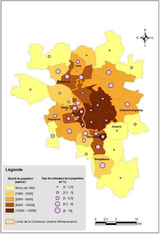
Ville, close to basic facilities and services. Urban development is exacerbated on the outskirts of Hell-
    Ville, whose built environment has doubled in just 10 years.
13. The decline of the sugar sector has led to a rush on SIRAMA land. Approximately 40% of the island
    of Nosy Be is titled in the name of the SIRAMA and this land is highly coveted today, the object of
    official transactions and de facto occupancies. The sprawl of SIRAMA’s land heritage is due to: (i) the
    land compensation of 700 workers laid off in 2006; (ii) the urban expansion of Hell-Ville in part on
    agricultural land that is no longer protected by a land title. This “squatterization” can be either
    individual or organized. The occupants sometimes form associations, often supported by political
    figures that defend their causes and thus cultivate a following. SIRAMA’s limited control capacity has
    led to the rapid expansion of illicit settlements. The parcels occupied are resold and are used for the
    construction of housing or hotel investments. Some 37% of the parcels were purchased (i) through
    direct and official transactions with SIRAMA; (ii) from laid-off workers; or (iii) from illicit occupants.
    A total of 90% of the occupancy of SIRAMA’s titled land takes place outside of the framework of
    official acquisitions. Households obviously do not have an official land document but claim a right of
    occupancy validated by different types of “small papers”, e.g., “authorization of occupancy” or
    “authorization to develop agricultural land”, issued by the sugar company and/or by the fokontany.
    There is even an unofficial land market specialized in these occupancy rights. This land can be taxed.
    Tax payment receipts are thus perceived as a land security tool that proves that the land has been
    previously occupied.
14. Irregular occupancy exposes families to the risk of eviction and is at the core of social tensions.
    Despite these local mechanisms aimed at recognizing occupancy, two-thirds of the households fear a
    challenge to the use rights that they obtained or were granted. Some 85% of them are particularly afraid
    that SIRAMA or the government could ask them to get off their land. Their immediate defense strategy
    is generally to join an association often created by the elite for political reasons. Irregular occupancies
    protected by important local figures generate tensions that can then escalate with respect to identity
    issues.

Section 2 – The economic and social consequences of inadequate land information

15. The overview of urban land management reveals an overall deficient situation at the institutional,
    legal, technical and social levels: only 25% of land information is updated and corresponds to the actual
    occupancy; collection of property taxes on building property (IFPB) reveals a loss of earnings of 61%;
    the number of land disputes is constantly increasing at the level of the courts and other legal bodies; the
    official land market is paralyzed and is limited to residential areas; the size of the majority of building
    parcels is much lower than the standards authorized by urban planning regulations, the “squatterization”
    of private property and anarchic occupancies in the public domain and high-risk areas increases every
    year; the rate of slum growth is approximately 70%.
16. Social and family tensions. The lack of transaction registrations has a major impact on the feeling of
    insecurity of the occupants who fear a challenge to their rights by the family, by public institutions or
    by third parties. Land disputes are often in the media spotlight, and public opinion estimates the rate of
    land conflicts brought before the courts at 80%. This proportion is probably closer to 30%, but some of
    the disputes can involve an entire neighborhood or hundreds of households.
17. Unreliable land information slows down and raises the cost of investments in urban infrastructure.
    Another consequence of the impossibility to record changes in land status is that public infrastructure
    projects are often subject to delays of several months since the process is blocked by unsolvable
    problems of identification of the beneficiaries to be expropriated and compensated.
18. The lack of updated land data hampers the collection of tax revenues. The management of property
    taxation (survey, tax base management, collection) has been the total responsibility of the municipalities
    since 2006, and it is based on a field survey and the declaration of the occupants. Due to the lack of a
    reliable land database, 61% of the buildings in the capital elude the IFPB, representing a considerable

                                                                                                            10
deficit. The lack of updating of the land database also deprives the government and the municipalities
of direct and indirect tax revenues.
Section 3 – Proposals for policy options to improve urban land governance
19. The aim is to develop a strategy adjusted to the constraints and to the context, and is in line with the
current strategies of the Malagasy government in relation to urban land management. The Land
Policy Letter (LPF) recommends the implementation of innovative approaches for the creation and
management of land and land use databases via a single structure at the level of the major cities. It also
proposes a consolidation of landholdings to accompany the restructuring of informal settlements and
slums. The National Urban Development Policy (PNDU), approved in 2019, considers land
management in urban areas to be a major challenge and proposes different options for upgrading the
sector. The proposals suggested must take account of a context marked by: (i) the almost total lack of
public land reserves; (ii) the limited capacities of the actors to update land information, reconstitute lost
or damaged documents, register changes in status, and massively validate existing rights; (iii) the little
interest expressed by the different administrations to consider alternatives to the land title; (iv) the impact
of social constraints linked to widespread poverty; and (v) a complex land occupancy with frequent joint
possession.
20. The observations of this report, like the guidelines of the PNDU, converge towards two main strategic
axes: (i) to provide the administration with an efficient urban land management system; and (ii) land
generation capable of addressing the projected demographic growth and the requirements in
infrastructures.
21. The guidelines chosen to improve land governance require the simultaneous implementation of the
following actions: (i) an assessment based on plot surveys in the field, of occupancy, developments,
land status and occupancy regime; (ii) the updating of land information managed by land administration
central units; (iii) the legal regularization of occupancies; (iv) the design and implementation of legal
and administrative reforms of procedures; (v) the restructuring and equipping of areas in need with basic
services; (vi) the creation of a reception area for new arrivals and for displaced persons within the
framework of restructuring or expulsion.
Recommendations for the Efficient Management of Urban Land
The improvement of urban land administration and management can be achieved in two stages:
Step 1: Updating land Action 1 – Acquire Very High Resolution (VHR) imagery.
information through a
systematic inventory and the
development of urban
PLOFs Action 2 – Superimpose the land information held by land
3 sequential actions administration on the image.
Action 3 – Carry out participatory field surveys, including women,
to establish an inventory of existing rights, occupation rights and
rights of way.
11Step 2 : Option 1: Secure rights by land title.
Formalize and Simplified cadastral operations or prescription procedure.
secure occupancy
through the use Option 2: Secure rights by land certificate.
of innovative Certification procedure adapted to the urban environment (i) for land whose title
tools cannot be updated given the cost and cumbersome nature of the procedures and
3 possible (ii) for land recorded in cadastre without ever having been registered.
options
Option 3: Secure rights by the official recognition of occupancy rights.
Recognition of occupancy rights, captured during the survey, and located on land that
is registered but whose title is difficult or impossible to update. The survey makes it
possible (i) to confirm titled properties whose current owner is the one registered on
the title; or (ii) to record on an ad hoc register the occupations of titled land when
they do not correspond with the information recorded in the land register.
• Step 1: To update land information via a systematic assessment and the development of urban
PLOFs (Local Land Occupancy Plans)
22. Regularly updated land information and the systematic development of urban Local Land Occupancy
Plans (PLOF) is highly recommended. The PLOF is a land status map, based on different laws and
decrees. It is assumed to represent the status of all the land included in a municipal land base. It is
developed from: (i) a very high-resolution background image; (ii) existing topographic and land
documentation; and (iii) systematic surveys of each parcel. It is considered as an upgraded land
identification map, shared by land services and municipalities, and must be updated as transactions take
place. It is carried out in three stages:
• Action 1 – Acquire Very High Resolution (VHR) Imagery. These are either satellite images,
aerial shots taken by plane or drone (see experiences from Zanzibar Annex 3, 1.1 and from the NGO
Habaka) meeting the recently specified topographical standards. 2 They must necessarily be
orthorectified according to the standards in effect.
• Action 2 – Superimpose the land information held by land administration departments on
the image. Retrieving land information held by government agencies remains a complex, costly
and often difficult to accomplish.3 This action would provide a layer of information on registered
land as recorded in government unit’s databases. This first step allows an initial, more or less
precise location of the titled land and the dependencies of the State domain. However, it remains
incomplete information because: (i) it reflects an old land situation that has not been updated for
years or even decades, and (ii) some documents relating to titles have disappeared or are so
damaged that they are unusable. This first layer of information can only be regarded as indicative
and cannot tell the law systematically.
• Action 3 – Carry out participatory field surveys to establish an inventory of existing rights,
occupation rights and rights of way. The inventory, as carried out in the framework of this study,
is an essential prerequisite for understanding the reality of occupations, the land tenure status of
plots and buildings, their compliance with town planning standards, land disputes and local dispute
settlement mechanisms. This reconstruction of land information must pay attention to taking into
account the rights registered or to be registered in the name of women or couples. It is essential to
2 Decree No. 27684 of 5 December 2019 defined the technical specifications of photogrammetric works.
3 However, it is important to note the positive experience of some services, among others in Tamatave and Atsimondrano, which
have succeeded, with the existing human and financial resources, in digitizing the plans that are still available and usable and
transferring them to an image.
12ensure the participation of all, especially women, in local consultations for the identification of
rights holders. The inventory made it possible to identify, parcel by parcel, land tenure status and
occupations and to measure the discrepancy between official land information and the actual on-
the-ground situation of the parcel. It could be carried out systematically in the targeted areas and
then gradually extended to the entire urban area. Costs and needs in terms of staff and equipment
still need to be assessed in order to determine an implementation schedule.
• Step 2: To formalize and secure occupancy on a large scale through the use of innovative tools
23. It is necessary to get past the notion of illegality of occupancies in order to secure them on a massive
scale. The recognition of occupancy is a major factor in the fight against poverty. What is the most
appropriate tool? A choice has to be made: to continue to manage urban land with the land title alone,
or to find an alternative? The advantages of the land title, which guarantees property rights in absolute
terms, are known, but its limits have also been recognized: (i) the complexity of the procedure generates
costs and lengthy delays that make the title relatively inaccessible; and (ii) few people officially register
sales and inheritances due to the costly and complex procedures involved. Moreover, the guarantee to
property provided by the title raises problems when the links between the current occupants and the
person or persons who have a land title cannot be established, when land documentation is unusable
because it has been lost or damaged, and when the boundaries have disappeared. In this context, the
design of land security tools in addition to the title alone is necessary and several options can be
examined.
24. If the policy choice does not provide for land security tools in addition to the land title, a first option
(Option 1) would be to consider coordinated State-owned land operations and/or acquisitive
prescription, but neither allow for large-scale actions.
• Option 1: Secure rights by land title. It is a question of proceeding either by simplified cadastral
operations, or by an “acquisitive prescription procedure” aiming at removing a property right with a
view to reassignment. Both procedures remain in the perspective of the issuance of a land title. They
mobilize substantial human and financial resources within the administration and have only been able
to be implemented in a limited way, often with international funding. The most recent evaluations of
cadastral operations have also shown mixed results.
25. If a policy choice is made for new tools to secure land tenure, in addition to land title, two new options
should be considered. First, the challenge is to strengthen, standardize and provide a framework for the
current land tenure security practices of households and local authorities. The small papers used today
provide a first level of formalization and security for transactions: purchase/sale; sharing; donation;
temporary transfer. They require the intervention of the owners (transferor and new buyer), call for
witnesses and are most often targeted by local authorities (fokontany, town hall, district). It is
recommended to support these local authorities in recording information systematically and rigorously
and making it public. This strengthening of the local level would make it possible to avoid certain
fraudulent practices. It would not require households to change their current practices, but only to
consolidate them, and thus would not require significant additional costs. Moreover, the legal equity
between men and women in accessing urban land will necessarily have to be reflected in the
formalization of rights.
• Option 2: Secure rights with a land certificate. Should and can certification be adapted to the land
tenure context of urban and peri-urban areas? To improve urban land tenure, the land certificate issued
by the communes, which also guarantees a right of ownership in line with simpler and cheaper
13procedures, could be a useful complement to the land title in peri-urban areas.4 It is proposed to use the
certification procedure for owners of formerly titled land, whose title cannot be updated due to the cost
and/or cumbersome procedures. This proposal can also be justified for land that has been registered for
several decades without ever having been registered. The proposed solution through certification has
met with different constraints as registration through land titling is final and the land title cannot be
replaced by another document.
• Option 3: Secure rights by the official recognition of occupancies. Between inaccessible registration
and certification unsuited to the urban land context, can an "Occupancy Register" be envisaged as an
intermediate solution? The aim is to recognize the occupancy rights, inventoried during the survey,
which are on the registered land layer but difficult or impossible to update. The survey makes it
possible (i) to confirm titled properties whose current owner is actually the one registered on the title;
and (ii) to officially record on an ad hoc register the occupations of titled land when they do not
correspond with the information recorded on the land register. The registration of such occupations
could involve (i) the registration free of charge of the descendant(s) occupying land registered in the
name of a relative; (ii) the parceling out of formerly registered land with no known owner; (iii) the
taking into account of transactions on the informal land market. In accordance with current practice,
these occupancy rights may be tradable and transferable, with the register of occupations recording the
various transactions at a lower cost and according to a local and simplified procedure.
26. The registration of occupancies is a major innovation that must be tested beforehand by the MATP and
placed within a legal framework in the future.
27. These different actions are to be taken in relation to zoning determined by urban planning
instruments. Urban development plans establish a general zoning that can guide regularization
operations in order not to officialize rights in unhealthy, high-risk areas. Depending on the social and
land tenure characteristics of the area, they can also determine a zoning of the different land security
options.
• Step 3: Should an agency responsible for the coordination and implementation of urban land
operations be created?
28. The implementation of the above recommendations can justify the creation of a dedicated agency
because it requires the establishment of new activities and approaches for the recognition and the
regularization of rights, bringing together local actors, elected officials, neighborhood leaders, and
NGOs working in the urban sector. It generates additional work, a large part of which must be outsourced
to private service providers, requiring an operational capacity for the management of contracts as well
as financial autonomy. In addition, in compliance with the indications in the Land Policy Letter and in
the perspective of broadening the scale of actions, a land agency could be responsible for this type of
operation, at the interface between the land services and the urban municipalities.
29. The Urban Development Agency of Greater Antananarivo (AUGA) could exercise a land jurisdiction
to implement the above proposals within the agglomeration of Greater Antananarivo Among its
functions, this recently created agency includes “the production of knowledge, particularly in relation
to land tenure, at the service of the development of the PLOFs and of the improvement of tax measures”,
in conjunction with the land services. Consequently, AUGA can, in partnership with the land services,
implement an assessment of rights, occupancies and existing footprints (Proposal 1) to update land
information. It can also contribute, together with the land services, to the development of the urban
4 As early as 2011, an expert was surprised by the paradox of not allowing urban communes to benefit from the decentralization of
land procedures (Comby, 2011) and suggested using communal land offices to regularize land parcels in urban areas.
14PLOFs in the municipalities where it has jurisdiction. The possibility that it could either undertake or
contribute to the regularization of occupancies by keeping an ad hoc register (Proposal 2) could also be
considered.
Summary and sequence of proposals for a dialogue for efficient urban land administration
and management
In summary, the proposals for efficient urban land administration and management suggest:
1. update land information by carrying out urban PLOFs to inventory and map properties and
occupations as they exist, based on a recent image;
2. regularize occupations according to three possible options, detailed in the table below; and
3. reflect on the value of entrusting responsibility for reconnaissance and regularization operations
to a dedicated institution.
15A national debate on urban land tenure should facilitate choices between three options, summarized in the following table:
Options and Key Activities Feasibility and Estimate of Advantages Risks Responsible
General Pre-Requisites cost and time institutions
Principles to implement
Option 1: − Updating of owners Low $54 / parcel The legal − Complexity of − State Land
Secure rights by according to 6 months to 1 framework does not procedures for Administration
land title. acquisitive Significant year need to be changed tracing the Department
Updating and prescription mobilization of succession of
generalization of procedures human and transactions
land titles issued − Fragmentation of old financial − Complexity of
by the land titles by State resources registration and
administration Transactions prescription
procedures
− The overload of the
land administration
does not allow for
large-scale plot
renovation
operations.
Option 2: − Equipping Low $11 / parcel − Simplified − Difficult to revise − Urban and peri-
Secure rights by municipalities with regularization the legal urban communities
land certificate. Land Offices. Legal principle of occupancy framework − State Land
Land − Regularization of of final through an − Weak collaboration Administration
regularization occupations through a registration to be existing and exchange of Department
requires an certification procedure amended regulatory information
adapted adapted to urban framework. between
Political will to
certification constraints. strengthen − Improvement municipalities and
procedure − Training of commune decentralization of land control land services
managed by the staff. by the − Commune
communes. municipalities capacities to be
in charge of strengthened
property
taxation
Option 3: − Use of the Medium Less than $10 / − Relatively − Legal framework − State Land
Secure rights by comprehensive parcel simple and for the Administration
the official inventory of Pilot required accessible regularization and Department
recognition of occupancy rights and policy regulation ex post facto − Communes?
management of
16occupancy conducted during the choice for − Mobilization of occupancy rights to − Dedicated Land
rights PLOF recognition of fewer human be developed Agency?
The occupations − Writing them in the occupations and financial − Need for prior
inventoried by Occupancy Registry resources experimentation
survey are
recorded in an ad
hoc register.
Option 3 seems most realistic. Securing land rights by updating and splitting up existing land titles seems prohibitive due to its cost and complexity.
The experiment of free transfer fees to encourage the regularization of private property in 2016 did not produced the expected results. Securing land
tenure through the certificate remains a possible option, but it requires first of all a reconsideration of the finality of the registration, and, therefore,
it is dependent on a political will to pursue the decentralization of land tenure competences. The recognition of occupancy rights is a potential
solution, as it promises to be simpler, less costly and can be tried out without waiting for the adoption of a specific regulatory framework. It is just
a matter of establishing occupation on formerly registered land and giving the occupant a document certifying not a right of ownership but a simple
occupation. This occupancy right could be considered as transferable. This innovation requires operational details to be worked out in a specific
pilot operation. Particular attention will be paid to the consideration of rights inscribed in the name of women or couples.
17These options can be established in the following order:
Short Term (6 months): − National forum on urban land issues for a shared assessment and agreement on
An Urban Land Tenure a strategy for improving urban land governance;
Improvement Strategy − Creation of a joint working group on urban land governance directed by the
MATP/National Land Fund, and responsible for the design of pilot operations;
− Design of pilot operations with different partners, and search for funding.
On the medium term, − Launch of pilot operations for occupancy surveys, and the renovation of the
from 6 to 18 months: a urban plot network;
choice of urban land − Assessment of pilot operations and feedback about the experiences from actors
policy based on in the urban land sector;
experience − Proposals for institutional and legal adjustments to facilitate the regularization
of land rights in urban areas.
In the long term, − Preparation of a National Urban Land Improvement Program. On the basis
beyond 18 months: the of pilot operations and these regulatory adjustments, this program could include
conception and design actions in three areas: (i) the strengthening of institutions responsible for urban
of a National Urban land tenure; (ii) regularization campaigns for land rights in urban areas; and (iii)
Land Improvement training of actors in the urban land sector;
Program − Launch of campaigns for the recognition of occupancies and the
regularization of land rights in urban areas in Antananarivo and other cities in
Madagascar.
General strategies for Urban Land Generation
30. The availability of updated land information and the recognition of occupancies and rights are essential
options, but are not sufficient by themselves. It is of utmost importance to produce land to meet the
demand for housing and facilities through urban upgrading, urban extensions, or the development of the
rental sector.
• Strategy 1: To develop restructuring and land security measures for poor areas
31. An assessment of available land reserves must take place before any restructuring can take place.
Before a restructuring proposal can be made, and in the perspective of a resettlement, the authorities
must be capable of assessing the area, the location, the status and the eventual allotment of financial
reserves. This information should be precisely mapped, and zones where information is unusable should
be identified.
32. Restructuring to free up land for housing and basic infrastructures. There are two possible ways of
doing this: eviction, which can be accompanied by resettlement measures, or total restructuring. Eviction
remains a complex social and economic issue. It is governed by expropriation procedures for the purpose
of public utility, but its administrative processing is long and often leads to disputes. It cannot be
considered as a default option in the case of one-off operations. Restructuring in situ is based on the
provision of essential urban services. Land requirements are thus limited to the establishment of several
new social infrastructures. Facilities are provided if the beneficiary community can reach an agreement
with the owner over land that is still free to accommodate a facility. However, this means of action is
limited because available land is rare and the rights are sometimes so confusing that investments for
basic facilities are called into question.
33. Carry out a total restructuring through land consolidation or pooling. This type of action favors
maintaining the inhabitants where they are, thus perpetuating social and economic links, but requires a
land development operation. Consolidation consists of regrouping parcels to allow each new property
to be developed in accordance with the urban development plan. Land pooling is a mechanism by which
the owners or occupants temporarily pool their land resources in a given area for the purpose of
18developing it and providing services for its inhabitants. When the operation is terminated, they each
retake possession of a part of their property and may benefit from a legal regularization. Part of the non-
restored land could be used for facilities. Another part could be put on the market to cover development
costs. A part could be allocated to social housing projects. Moreover, and beyond the intervention of the
State, international experiences have shown the possibility of improving access to land via a community-
based organization. Several international experiences have revealed practices that may be of interest for
Madagascar and, in particular, land sharing and community land trusts.
34. Implementing restructuring operations within the framework of a Joint Development Zone (ZAC).
The ZAC is a zone determined by urban development plans where a public institution develops land and
undertakes a restructuring without necessarily acquiring the land beforehand. Insofar as Madagascar has
no experience with this type of urban operation, it has to be tested beforehand via pilot operations, in
particular, within the framework of the PRODUIR project.
35. Implementing a full-scale urban land management laboratory within the PRODUIR framework. The
project is thus considering a total urban renewal operation in favor of the resettlement in situ of people
affected by the project. A PUDé will determine the main weak areas to be restructured. Depending on
the degree of complexity of the land tenure situation and a level of restructuring adapted to each zone,
the project will be able to implement different land tenure solutions within the framework of pilot
operations. This will involve:
i. Updating land tenure information by the PLOF in a participatory manner and with the use of aerial
images taken by a drone, systematic surveys and surveys of the actual plot network;
ii. Conducting an public information campaign in the areas in question to explain the benefits of a
renewal operation;
iii. Setting up a forum for dialogue between the community, landowners and the public authorities
under the leadership of the municipality;
iv. Establishing the Joint Development Zone (ZAC);
v. Inclusively defining development operations and adjusting urban planning standards to the social
characteristics of the areas concerned;
vi. Regularizing occupancies and property rights;
vii. Establishing an authority in charge of restructuring;
viii. Capitalizing on the experience for the purpose of drawing up proposals for legal and regulatory
adjustments.
• Strategy 2: To increase and diversify the land supply in order to improve its affordability
36. Systematize urban development plans to determine the standards adjusted to the context and diversify
the land supply. Urban development and building standards must be adapted to the needs and the
capacities of the majority of the households, and not the contrary. The LUH imposes a minimum area
of 150 m2 for building parcels, whereas 30% of the dwellings in the CUA are built on smaller-size
parcels. Derogations can be granted to prevent housing and the concerned areas from being considered
as illegal and thus deprived of regular access to facilities. Urban development plans make it possible to
adopt regulations adapted to the standard of living of the inhabitants, and should be developed
systematically.
37. Create land reserves for the development of trunk infrastructure. Their creation can be included in
urban development plans and be provided for in agreement with existing procedures (expropriation,
preemption, restructuring, joint planning, etc.) to give them a legal basis and to ensure government
control over land. In these reserves and in the spirit of major trunk infrastructure, the land supply must
be adapted to the demand of low-income households by making available land, whose area is less than
the current standard, summarily fitted and equipped, but that will eventually be improved by the
beneficiaries themselves.
19You can also read