Town of Burrillville Rhode Island Hazard Mitigation Plan 2021 Update July 1, 2021
←
→
Page content transcription
If your browser does not render page correctly, please read the page content below
Town of Burrillville Rhode Island
   Hazard Mitigation Plan
         2021 Update
          July 1, 2021

                                    1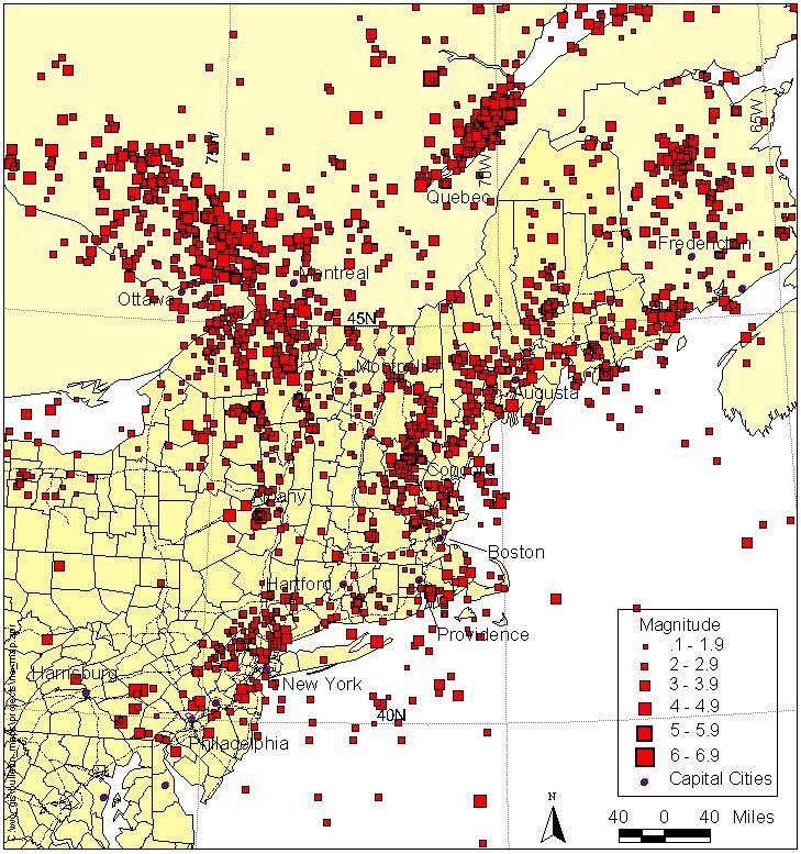
Contents
Executive Summary....................................................................................................................................... 4
   What is Hazard Mitigation? ...................................................................................................................... 4
   Hazards...................................................................................................................................................... 4
   Mitigation Actions ..................................................................................................................................... 5
1.0- Introduction ........................................................................................................................................... 6
   What is Hazard Mitigation? ...................................................................................................................... 7
   Mitigation Benefits ................................................................................................................................... 7
   Sustainable Communities ......................................................................................................................... 8
   Mission and Goals ..................................................................................................................................... 8
   The National Flood Insurance Program (NFIP)........................................................................................ 10
   Community Rating System (CRS) ............................................................................................................ 11
       Benefits of the Community Rating System ......................................................................................... 12
       Floodplain Management Goals / Reducing Flood Risks ...................................................................... 11
   Historical Flood Vulnerability .................................................................................................................. 49
   Repetitive Losses..................................................................................................................................... 11
2.0 Town of Burrillville Profile..................................................................................................................... 12
   General Information ............................................................................................................................... 14
   General Demographic Characteristics .................................................................................................... 15
   Town Infrastructure ................................................................................................................................ 15
       Critical Facilities .................................................................................................................................. 16
       Vulnerable Populations ....................................................................................................................... 17
       Economic Assets.................................................................................................................................. 18
       Special Considerations ........................................................................................................................ 18
       Critical Facilities .................................................................................................................................. 20
Section 3.0 Planning Process ...................................................................................................................... 22
   Hazard Mitigation Committee ................................................................................................................ 22
   Methodology........................................................................................................................................... 23
   Incorporation of Mitigation into Planning Mechanisms ......................................................................... 27
   Incorporation of Mitigation into Emergency Management ................................................................... 27
Section 4.0 Hazard Identification, Vulnerability and Risk Assessment ....................................................... 29
   Risk Assessment ...................................................................................................................................... 30
       Frequency............................................................................................................................................ 31

                                                                                                                                                                2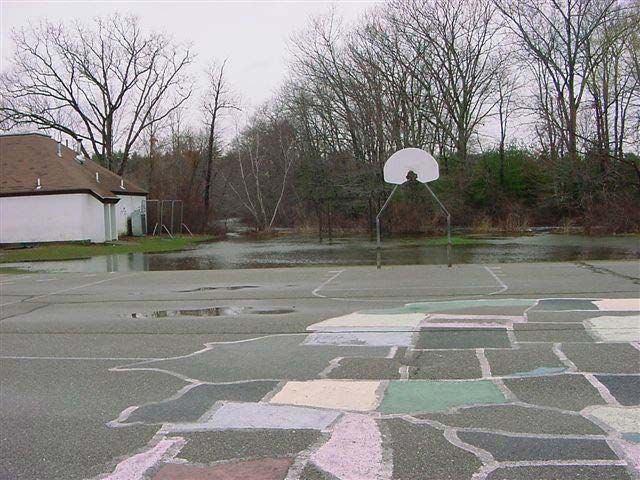
Area of Impact..................................................................................................................................... 31
Magnitude ........................................................................................................................................... 32
Hazard Description and Vulnerability Assessment ................................................................................. 33
Aquifer Contamination- Risk Score 21.45 ........................................................................................... 33
Critical Incidents- Risk Score 5.2 ......................................................................................................... 34
Dam Failure- Risk Score 18.13............................................................................................................. 36
Drought- Risk Score 13.00 ................................................................................................................... 39
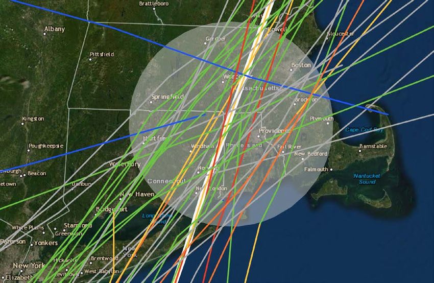
Earthquake- Risk Score 10.12 ............................................................................................................. 42
Flood- Risk Score 20.74 ....................................................................................................................... 45
Hazardous Materials Events- Risk Score 14.52 ................................................................................... 52
Hurricane and Tropical Storms- Risk Score 25.08 ............................................................................... 54
Lightning- Risk Score 12.98 ................................................................................................................. 59
Severe Winter Storms- Risk Score 28.86............................................................................................. 60
Temperature Extremes- Risk Score 11.66 ........................................................................................... 62
Tornado- Risk Score 6.96 .................................................................................................................... 64
Wildfires- Risk Score 7.92.................................................................................................................... 68
Section 5.0 Mitigation Actions .................................................................................................................... 70
Section 6.0 Implementation........................................................................................................................ 76
Maintenance and Update Schedule of the Hazard Mitigation Plan .......... Error! Bookmark not defined.
Continued Public Involvement ................................................................................................................ 77
Evaluation of Mitigation Actions................................................................ Error! Bookmark not defined.
3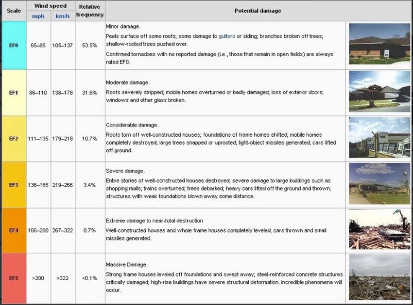
Executive Summary
The Town of Burrillville has undertaken this update to its Hazard Mitigation Plan in an attempt to better
understand and reduce disaster risk within the Town. Since the 2014 plan update, the Town has self-
funded significant achievements to reduce disaster risk. Luckily, the Town has only experienced one
presidentially declared disaster, a Severe Winter Storm (DR-4212), resulting in $63,124 of costs. Other
than these improvements and one disaster, the Town of Burrillville has only experienced insignificant
changes that would not impact hazard mitigation planning.

This plan is designed to document the significant planning process undertaken by Town leaders and
residents to create a reasoned plan for hazard mitigation. The major sections of the plan include the
following:

       •    Introduction- Describes the purpose of the plan
       •    Community Profile- Provides demographic and geographic information about Burrillville
       •    Planning Process- Describes steps taken to revise the plan
       •    Hazard Identification and Risk Assessment- Discusses hazard identification and risk assessment
            that includes descriptions and potential impacts and capabilities
       •    Mitigation Actions- Steps taken to address the hazard identified in the plan
       •    Implementation- Identifies the actionable steps, responsible parties, and timetable

What is Hazard Mitigation?

As defined in 44 CFR 201.2, hazard mitigation means any sustained action taken to reduce or eliminate
the long-term risk to human life and property from hazards. 1 As the direct and indirect costs of disasters
continue to rise, it becomes particularly critical that preparing for the onslaught of damage from these
events must be done to reduce the amount of damage and destruction. This strategy is commonly
known as mitigation. The purpose of multi-hazard mitigation is twofold: 1) to protect people and
structures from harm and destruction, and 2) to minimize the costs of disaster response and recovery.

Hazards

The Local Hazard Mitigation Committee (LHMC) also reviewed the hazards presented in the 2014 plan
and updated them based on new concerns expressed, additional research, and the State of Rhode
Island’s 2019 State Hazard Mitigation Plan Update 2. The chart below details the hazards from the 2014
Plan compared to the 2021 Plan:

                            2014 Hazards                                 2021 Hazards
                    Dam Failures                            Aquifer Contamination

1   44 CFR 201. Accessed via: https://www.law.cornell.edu/cfr/text/44/201.2 18 January 2020
2   http://www.riema.ri.gov/RIHMP_FullPlan_Reduced.pdf

                                                                                                             4
Droughts                            Critical Incidents
               Earthquakes                         Dam Failure
               Floods                              Droughts
               Hazardous Materials Events          Earthquakes
               Hurricane & Tropical Storms         Flood
               Nor'easters                         Hazardous Materials Events
               Severe Winter Storms                Hurricanes & Tropical Storms
               Temperature Extremes                Infectious Disease
               Tornados                            Lightning
               Wildfires/Conflagration             Severe Winter Storms
                                                   Temperature Extremes
                                                   Tornado
                                                   Wildfire

Each hazard was rated by the individual committee members using available data and their area of
expertise. The committee members scored the frequency, area impact, and potential damage
magnitude of the hazard. The scores were reviewed amongst the group to ensure consistency. The final
hazard score was used by averaging each committee members score and putting it through this formula:

    •   Total Score = (Frequency + Area Impact) x Potential Damage Magnitude

Ultimately, the top three hazards from the Town of Burrillville were Severe Winter Storms, Hurricane &
Tropical Storms, and Aquifer Contamination.

Mitigation Actions

The Town of Burrillville made a significant investment in mitigation during this planning cycle. Focusing
on reducing flooding within Town and was able to complete 10 mitigation projects identified in the 2014
Plan. Due to changing situations within Town and on the State level, three prior mitigation actions were
deemed not feasible. Six new mitigation projects have been added to the update of this plan. They
include:

    •   Identifying potential threats to the water supply
    •   Developing a new wellhead/potable water source
    •   Installing a new supply pipe for the Cherry Farm Road Tank
    •   Installing 3 communication towers to address communications issues
    •   Upgrading the Town’s Dispatch Center
    •   Conducting a lightning protection survey

Overall, the Town of Burrillville is committed to reducing disaster risk to its residents and businesses.

                                                                                                            5
1.0- Introduction
Disasters are becoming more costly. Since the last update of the Town’s Hazard Mitigation Plan, ten or
more billion-dollar weather and climate disaster events have impacted the United States 3 each year.
The National Oceanic and Atmospheric Administration’s National Centers for Environmental Information
has cataloged the information and the chart below summarizes these findings:

4

This alarming trend has been identified by the Town of Burrillville which has chosen to be proactive by
keeping updated the Town’s Hazard Mitigation Plan.

The purpose of this Hazard Mitigation Plan is to set in motion short-term and long-term actions, which
will reduce the actual or potential loss of life or property from hazardous events such as winter storms,
flooding, severe storms, droughts, hurricanes, and earthquakes. This plan is a directive of the Federal
Emergency Management Agency and conforms specifically to 44 CFR Parts 201 and 206 Hazard
Mitigation Planning and Hazard Mitigation Grant Program: Interim Final Rule. The Town of Burrillville,
upon adoption of this plan, will become an eligible applicant for various mitigation grant funding
opportunities including the Hazard Mitigation Grant Program (HMGP). These grant resources may be
used to mitigate the effects of natural hazards on both public and private property.

3   https://www.ncdc.noaa.gov/billions/
4   https://www.ncdc.noaa.gov/billions/summary-stats

                                                                                                            6
What is Hazard Mitigation?

As defined in 44 CFR 201.2, hazard mitigation means any sustained action taken to reduce or eliminate
the long-term risk to human life and property from hazards. 5 As the direct and indirect costs of disasters
continue to rise, it becomes particularly critical that preparing for the onslaught of damage from these
events must be done to reduce the amount of damage and destruction. This strategy is commonly
known as mitigation. The purpose of multi-hazard mitigation is twofold: 1) to protect people and
structures from harm and destruction, and 2) to minimize the costs of disaster response and recovery.

To ensure the national focus on mitigation, the Federal Emergency Management Agency (FEMA)
introduced a National Mitigation Strategy in 1995. The strategy promotes the partnership of
government and the private sector to “build” safer communities. Hazard mitigation encourages all
Americans to identify hazards that may affect them or their communities and to take action to reduce
risks.

Mitigation Benefits

Mitigation actions help safeguard personal and public safety. Retrofitting bridges, for example, can help
keep them from being washed out, which means they will be available to fire trucks and ambulances in
the event of a storm. Installing hurricane clips and fasteners can reduce personal and real property
losses for individuals. It can also reduce the need for public assistance in the event of a hurricane.
Increasing coastal setbacks reduces the risk of deaths and property losses from tsunamis and storm
surge. Increased setbacks also reduce the risk of property losses from coastal erosion.
Another important benefit of hazard mitigation is that money spent today on preventative measures can
significantly reduce the impact of disasters in the future, including the cost of post-disaster cleanup.
The following is stated under Section 322 of the Robert T. Stafford Disaster Relief and Emergency
Assistance Act, as amended by Section 104 of the Disaster Mitigation Act of 2000:

         “To obtain Federal assistance, new planning provisions require that each state, local and
         tribal government prepare a hazard mitigation plan to include sections that describe the
         planning process, an assessment of the risks, a mitigation strategy, and identification of
         the plan maintenance and updating process.”

The adoption of this multi-hazard mitigation strategy will enhance Burrillville’s eligibility for federal
grants, which include FEMA’s pre-disaster Flood Mitigation Assistance (FMA) program and its post-
disaster Hazard Mitigation Grant Program (HMGP). Pre-disaster planning will also help post-disaster
operations become more efficient. For instance, procedures and necessary permits can be identified
before the disaster, and therefore, permit streamlining procedures can be put into place. Priorities for
mitigation during reconstruction can also be identified, helping to reduce the high costs of recovery
after a disaster. The State emergency response effort will run more smoothly because of the guidance
provided in this strategy.

544 CFR 201. Accessed via: http://www.gpo.gov/fdsys/pkg/CFR-2011-title44-vol1/pdf/CFR-2011-title44-vol1-sec201-2.pdf 17
September 2012

                                                                                                                          7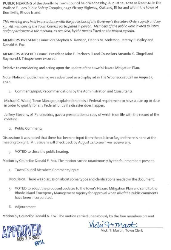
Sustainable Communities

        “A resilient community is one that lives in harmony with nature’s varying cycles and processes.”

                                        David Godschalk, Timothy Beatley, et. al.

“Disaster resilient” communities employ a long-range, community-based approach to mitigation.
Mitigation advocates for communities to proactively address potential damage that could occur from
hurricanes, coastal erosion, earthquakes, flooding, and other natural hazards. When natural hazard
mitigation is combined with the standards of creating sustainable communities, the long-term beneficial
result is smarter and safer development that reduces the vulnerability of populations to natural
disasters while reducing poverty, providing jobs, promoting economic activity, and most importantly,
improving people’s living conditions. 6 In addition to a community’s sustainability criteria for social,
environmental, and economic protection, there is also the criterion that development must be disaster-
resistant. 7

Resilient communities may bend to the impact of natural disaster events, but they do not break. They
are constructed so that their lifeline systems of roads, utilities, infrastructure, and other support
facilities are designed to continue operating during high winds, rising water, and shaking ground.
Hospitals, schools, neighborhoods, businesses, and public safety centers are located in safe areas, rather
than areas prone to high hazards. Resilient and sustainable communities’ structures are built or
retrofitted to meet the safest building code standards available. It also means that their natural
environmental habitats such as wetlands and dunes are conserved to provide the natural benefits of
hazard mitigation.

The Burrillville Hazard Mitigation Plan advocates the concepts of disaster-resilient and sustainable
communities. Burrillville is committed to building a disaster-resistant community and achieving
sustainable development through the commitment of state and local government and its policymakers
to mitigate hazard impacts before disaster strikes. Additionally, Burrillville will achieve a disaster-
resilient, and therefore, safer community, through the process of completing its Hazard Risk and
Vulnerability Assessment (RVA), and Multi-Hazard Mitigation Strategy (HMS) and through the
implementation of mitigation programs and policies. The Town will have the capability to implement
and institutionalize hazard mitigation through its human, legal, and fiscal resources, the effectiveness of
intergovernmental coordination and communication, and with the knowledge and tools at hand to
analyze and cope with hazard risks and the outcomes of mitigation planning.

Mission and Goals

The missions of the Town of Burrillville multi-hazard mitigation strategy are to:

6   Munasinghe and Clarke, 1995.
7   Institute for Business and Home Safety, 1997; FEMA, 1997.

                                                                                                           8
1. Provide coordinated, consistent goals for reducing or minimizing human and property losses,
       major economic disruption, degradation of ecosystems and environmentally critical habitats,
       and destruction of cultural and historical resources from natural disasters.

    2. Provide transparency to the risks faced within the Town as well as the proactive steps being
       taken by town and community leaders to address current and future challenges.

    3. Provide a basis for intergovernmental coordination in natural hazard mitigation programs at the
       state and local levels.

    4. Develop partnerships between the Town, private sector, local districts, and non-profit
       organizations to coordinate natural hazard mitigation programs.

    5. Identify and establish close coordination with local government departments and agencies
       responsible for implementing the sound practices of hazard mitigation through building
       standards and local land use development decisions and practices.

    6. Provide for continuing public education and awareness about the risks and losses from natural
       disasters, and natural hazard mitigation programs, policies, and projects.

The goals of the multi-hazard Burrillville Mitigation Strategy are to:

    1. Protect public health, safety, and welfare.

    2. Reduce property damages caused by natural disasters.

    3. Minimize dislocation and social distress.

    4. Reduce economic losses and minimize disruption to local businesses.

    5. Protect the ongoing operations of critical facilities.

    6. Reduce the dependence and need for disaster assistance funding after natural disasters.

    7. Expedite disaster mitigation efforts during the recovery phase of a disaster.

    8. Promote non-structural flood measures to reduce the risk of damage to the surrounding
       properties and environmental habitats.

    9. Continue to enhance and maintain the LHMC to support, implement and revise the Burrillville
       multi-hazard mitigation strategy and to provide the support necessary for an ongoing forum for
       the education and awareness of multi-hazard mitigation issues, program, policies, and projects.

                                                                                                         9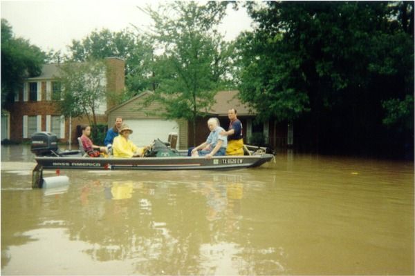
10. Provide for adequate financial and staffing resources to implement the Burrillville Hazard
        Mitigation Strategy.

    11. Incorporate the best available information and practices into the development of Town
        mitigation actions.

    12. Educate the public about the benefits of hazard mitigation.

The National Flood Insurance Program (NFIP)

In 1968, Congress created the National Flood Insurance Program (NFIP) in response to the rising cost of
taxpayer-funded disaster relief for flood victims and the increasing amount of damage caused by floods.
The Federal Insurance and Mitigation Administration (FIMA) a component of the Federal Emergency
Management Agency (FEMA) manages the NFIP and oversees the floodplain management and mapping
components of the program.

Communities participate in the NFIP by adopting and enforcing floodplain management ordinances to
reduce future flood damage. In exchange, the NFIP makes federally subsidized flood insurance available
to homeowners, renters, and business owners in these communities. Flood insurance, Federal grants
and loans, Federal disaster assistance, and Federal mortgage insurance is unavailable for the acquisition
or construction of structures located in the floodplain shown on the NFIP maps for those communities
that do not participate in the program.

To get secured financing to buy, build, or improve structures in Special Flood Hazard Areas (SFHA), it is
legally required by federal law to purchase flood insurance. Lending institutions that are federally
regulated or federally insured must determine if the structure is in a SFHA and must provide written
notice requiring flood insurance. Flood insurance is available to any property owner located in a
community participating in the NFIP.

Flood damage is reduced by nearly $1 billion a year through partnerships with communities, the
insurance industry, and the lending industry. Further, buildings constructed in compliance with NFIP
building standards suffer approximately 80 percent less damage annually than those not built compliant.
Additionally, every $3 paid in flood insurance claims saves $1 in disaster assistance payments.

The NFIP is self-supporting for the average historical loss year, which means that operating expenses
and flood insurance claims are not paid for by the taxpayer, but through premiums collected for flood
insurance policies. The program has borrowing authority from the U.S. Treasury for times when losses
are heavy; however, these loans are paid back with interest.

The Town of Burrillville had a Community Assistance Visit during the update to the mitigation plan on
December 19, 2019. The purpose of the meeting was to discuss the Town’s participation in, and
obligations to, the National Flood Insurance Program (NFIP). The intent of the meeting was also to assist,
if necessary, in strengthening the review and enforcement of NFIP standards. The result of the meeting

                                                                                                            10
was positive and revealed little new development in the floodplain and the State Floodplain Coordinator
concluded the local officials had a comprehensive understanding of NFIP and floodplain management.
Floodplain Management Goals / Reducing Flood Risks
A major objective for floodplain management is to continue participation in the National Flood
Insurance Program. Communities that agree to manage Special Flood Hazard Areas shown on the NFIP
maps participate in the NFIP by adopting minimum standards. The minimum requirements are the
adoption of the Floodplain Ordinance and Subdivision/Site Plan Review requirements for land
designated as Special Flood Hazard Areas.
Federally subsidized flood insurance is available to any property owner located in a community
participating in the NFIP. Communities that fail to comply with NFIP will be put on probation and/or
suspended. Probation is a first warning where all policyholders receive a letter notifying them of a $50
increase in their insurance. In the event of a suspension, the policyholders lose their NFIP insurance and
are left to purchase insurance in the private sector, which is of significantly higher cost. If a community
is having difficulty complying with NFIP policies, FEMA is available to meet with staff and volunteers to
work through the difficulties and clear up any confusion before placing the community on probation or
suspension.
According to NFIP policies, when an applicant files a request for a building permit in the floodplain, the
applicant must include an elevation certificate to comply. If an applicant intends to fill onsite, a Letter of
Map Revision (LOMR) must be submitted along with the application. According to NFIP requirements in
the Floodplain Ordinance, building permits should be reviewed to assure sites are reasonably safe from
flooding, and requirements for anchoring to prevent flotation, collapse, or lateral movement as well as
construction using flood-resistant materials is being followed.
To reduce flood risks, the Code Enforcement Officer/Building Inspector should be familiar with the
Floodplain Ordinance and the NFIP. Additionally, the Planning Board should be familiar with NFIP
policies, especially those regulations that are required to be incorporated into the Subdivision/Site Plan
Review regulations. A workshop sponsored by the Rhode Island Emergency Management Agency would
be appropriate to educate current staff and volunteers.
An essential step in mitigating flood damage is participation in the NFIP. The Town of Burrillville works
to consistently enforce NFIP compliant policies to continue its participation in this program.
Repetitive Losses
Repetitive losses are those structures that are covered under an NFIP flood insurance policy and:
(a) That has at least four NFIP claim payments (including building and contents) over $5,000
each, and the cumulative amount of such claims payments exceeds $20,000; or
(b) For which at least two separate claims payments (building payments only) have been made
with the cumulative amount of the building portion of such claims exceeding the market value
of the building.
11For both (a) and (b) above, at least two of the referenced claims must have occurred within any ten
years and must be greater than 10 days apart.8
FEMA mitigation funds are available to States so that the riskiest repetitive flood loss properties can be
targeted offering the owners financial help to get their buildings high and dry‐‐either moved to a safer
location or elevated well above flood elevations. The National Flood Insurance Agency (FIA) is
considering a change in their regulations so that policyholders under the flood insurance program who
decline an offer of FEMA's mitigation funds to move or elevate their property would pay full-risk
premiums for flood coverage. Currently, consistent with the grandfather provisions of the flood
insurance program's authorizing legislation, the FIA charges the owners of properties built before we
developed detailed flood risk information less than full‐risk premiums. These older structures have been
eligible for the reduced premiums account for nearly all of the repetitive loss properties insured under
the flood insurance program.
Community Rating System (CRS)
When communities go beyond the minimum standards for floodplain management, the Federal
Emergency Management Agency’s (FEMA) National Flood Insurance Program (NFIP) Community Rating
System (CRS) provides discounts up to 45 percent off flood insurance premiums for policyholders in that
community. Formal adoption and implementation of this strategy will help Burrillville gain credit points
under the CRS. For example, points are given to municipalities that form a Local Hazard Mitigation
Committee (LHMC). Communities also receive points if they involve the public in the planning process,
coordinate with other agencies, assess the hazard and their vulnerability, set goals, draft an action plan
(local hazard mitigation strategy), and adopt, implement, and revise the plan.
There are many categories to gain credit for public
education and awareness activities regarding floodplain
management and mitigation. The maintenance of non-
federally owned open space land in floodplains can also
help a municipality gain credit points under the CRS
program. Also, vegetated open-space land enhances the
natural beauty and the beneficial functions that
floodplains serve while helping to prevent flood damage.
Benefits of the Community Rating System
Not only do CRS activities save money, but they also
protect the environment and improve the quality of life —
even when there is no flood. For example, when the Town
of Burrillville preserves open space in the floodplain, the
residents will get to enjoy the natural beauty of the land. If there is a flood, here are some of the many
benefits CRS activities bring:
8 http://www.fema.gov/severe-repetitive-loss-program
12• CRS activities prevent property damage.
• Avoid lost jobs and economic devastation caused by flooding in offices, factories, farms, stores,
and other businesses.
• Prevent damage and disruption to roads, schools, public buildings, and other facilities you rely
on every day.
• May reduce casualties if setbacks decrease the impact of physical structures.
The State Floodplain Coordinator encouraged local officials to participate in the Community Rating
System, however, the Town has elected not to participate due to the low number of properties,
premiums, and claims.
132.0 Town of Burrillville Profile
When preparing a mitigation strategy, it is imperative to assure that the plan encompasses all aspects of
the Town. To assure that this was the case, the LHMC first studied the current situation of the Town of
Burrillville, namely the climate, geography, and demographics. We also performed a historical review to
assure that the Town of Burrillville Mitigation Strategy brings together every aspect of the Town. This
section will serve as a foundational summary for the Burrillville Mitigation Strategy.
General Information
Burrillville is a rural/suburban town located in the northwest corner of Rhode Island, bordered on the
north by Massachusetts and on the west by Connecticut. Burrillville is approximately twenty miles from
Providence, Rhode Island, 45 miles from Boston, and 190 miles from New York City. Burrillville has a land
area of 57.3 square miles with many lakes and streams.
The Town of Burrillville was separated from the Town of Glocester, RI, and incorporated in 1806. It was
named for James Burrill Jr., then State Attorney General, in recognition of his services in establishing the
new town. One of the main reasons for the creation of the new town was the people living in what was
to become Burrillville disliked having to travel to the village of Chepachet to conduct official business
and attend town meetings.
Burrillville grew quickly, its economy fed by a textile industry which continued to be of major
importance until the 1950s when the textile industry in the Northeast began to move to the South. It
was Burrillville's mills that led to the development of the town's many small villages.
The Town of Burrillville is a municipal corporation operating under the General Laws of Rhode Island and
utilizes a Town Council/Town Manager form of government with seven elected members headed by a
Council President. The Burrillville School District is directed by a seven-member School Committee. The
town has three elementary schools, a middle school (grades 6-8) and one high school (grades 9-12).
Burrillville, Rhode Island is located in the Northwest corner
of Rhode Island. It contains 57.1 square miles and has a
population of 16,740 people according to the 2018 Census
Estimate.
Geography and Climate
A generally rural community, that is dotted throughout by
many lakes and ponds. Summer temperatures tend to be in
the 53-76 F/12-24 C range. There are some 90+F/ 32+ C days,
mostly in July, but the afternoon sea breeze keeps most
summer highs in the low 80s F/27 C. September and October
are generally clear, with highs in the mid 60s to mid 70s F/17-
23 C. Winter is wet, sometimes snowy, sometimes icy and
chilly (18 to 37 F/-8 to -3 C).
14General Demographic Characteristics
• Population: The population count for The Town of Burrillville as of the 2018 Census Estimate,
was 16,740. This represented a +4.9% increase from the 2010 population of 15,953 9.
• Age Distribution: In 2018 it was estimated that 5.2% were under 5 years old, 20.4% are under
18 years old and 14.5% is 65 or older.
• Population Density: The 2018 population density estimate for Burrillville is 290 persons per
square mile of land area. Burrillville contains 55.56 square miles of land area (143,908,049 sq.
meters) (35,560.73 acres) and 1.58 square miles of water area (4,097,389 square meters)
(1,011.2 acres).
• Housing Units: The total number of housing units in the Town of Burrillville as of April 1, 2010,
was 6,419. This represented an increase of 598 units from the 5,821 housing units in 2000. Of
the 6,419 housing units, 550 were vacant. 230 of the vacant units were for seasonal or
recreational use.
• Households: In 2018, there are 6,053 households in Burrillville with an average size of 2.64
persons. 75.2% of these units are recorded as owner-occupied.
• Race and Hispanic Origin: The Town sees the following percentages of races and origins within
their population:
o White: 94.7%
o Black or African American: 0.9%
o Asian: 1.4%
o Two or More Races: 2.4%
o Hispanic or Latino: 2.3%
Town Infrastructure
The analysis, assessment, and identification of assets within a community are integral to determining
what may be at risk for loss from a natural disaster. This section examines the assets in four separate
categories: Critical Facilities, Vulnerable Populations, Economic Assets, and Special Considerations.
Each category lists the facility’s address and which hazard(s) it is vulnerable to. The hazards listed are
primarily natural disasters but can also include secondary disasters such as sewer/water line rupture, or
human-made disasters/emergencies such as automobile accidents.
In Burrillville, each asset can be damaged by all the hazards in Section 4.0. The Critical Facilities have
been plotted on the large map which can be found at the end of this section. When the asset was not
specifically vulnerable to one or more hazards, the term “All” was used to signify the asset’s
vulnerability to all possible hazards.
9 https://www.census.gov/quickfacts/burrillvilletownprovidencecountyrhodeisland
15Critical Facilities
Critical Facilities are categorized as those Town or State buildings or services that are the first
responders in a disaster. Fire departments, police departments, highway departments, and City/State
offices play a pivotal role in coordinating and implementing emergency services in the event of a
disaster. Other critical facilities include hospitals, airports, and schools that are used as shelters. The
office of the Department of Public Works is also included, as road maintenance plays a key role in
disaster response.
Key Facilities
Facility Address Lat/Long Hazard
105 Harrisville Main Street, 41°57'59.27" N, Snow,
Burrillville Town Hall Harrisville, RI 02830 71°40'39.42" W Wind
Town Hall Annex, Carlton 144 Harrisville Main Street, 41°57'55.63" N, Snow,
Brown Bldg. Harrisville, RI 02830 71°40'35.40" W Wind
1477 Victory Highway PO Box 41°57'51.96" N, Snow,
Burrillville Police Station 231Burrillville, RI 02830 71°38'35.75" W Wind
200 Clear River Drive Oakland, RI 41°58'1.14" N, Snow,
Burrillville Public Works 02859 71°41'40.97" W Wind
201 Callahan School Street, 41°58'7.13" N, Snow,
Harrisville Fire District Harrisville, RI 02830 71°40'44.36" W Wind
2577 Victory Highway, Harrisville, RI 41°58'48.18" N, Snow,
Nasonville Fire District 02830 71°36'45.68" W Wind
Oakland/Mapleville Fire 46 Oakland School Street, Oakland, 41°57'36.03" N, Snow,
District RI 02858 71°38'46.09" W Wind
105 Pascoag Main Street, Pascoag, RI 41°57'25.60" N, Snow,
Pascoag Fire District 02859 71°42'4.02" W Wind
Wallum Lake Fire 2090 Wallum Lake Road, Pascoag, RI 41°59'50.03" N, Snow,
Department 02859 71°45'45.02" W Wind
Burrillville School 2300 Broncos Highway, Harrisville, RI 41°58'52.85" N, Snow,
Department 02830 71°37'15.79" W Wind
100 Tinkham Lane, Harrisville, RI 41.965204 N, Snow,
Jesse M. Smith Library 02830 71.674586 W Wind
Schools
School Address Lat/Long Hazard
Steere Farm 915 Steere Farm Road, Harrisville, RI 41°57'12.15" N,
Elementary 02830 71°40'22.27" W Snow
Burrillville Middle 2220 Broncos Highway, Harrisville, RI 41°58'53.50" N,
School 02830 71°37'21.49" W Snow
41°58'5.80" N,
Burrillville High School 425 East Avenue, Harrisville, RI 02830 71°39'44.20" W Snow
75 Callahan School Street, Harrisville, RI 41°58'8.28" N, Flooding,
W.L. Callahan School 02830 71°40'57.66" W Snow
AT Levy Elementary 135 Harrisville Main St., Harrisville, RI 41°57'56.27" N,
School 02830 71°40'36.90" W Snow
16Community Christian 41°57'31.28" N, Wind,
School 111 Church Street Pascoag, RI 02859 71°42'21.34" W Snow
Utilities
Department Address Lat/Long Hazard
Pascoag Utility District (water, 253 Pascoag Main Street, Pascoag, RI 41°57'36.48" N, Wind,
electric) 02859 71°41'57.16" W Snow
Pascoag Utility District water 44 Silver Lake Avenue, Pascoag, RI 41°57'51.51" N,
department 02859 71°41'56.10" W Earthquake
Pascoag Utility District water 41°57'7.55" N, Wind,
tower Rock Avenue, Pascoag, RI 02859 71°42'21.90" W Earthquake
Pascoag Utility District water 41.946131 N Wind,
tower South Main Street, RI 02859 71.691067 W Earthquake
Wind,
Snow,
Harrisville Fire District (water) 115 Central Street, Harrisville, RI 41°57'42.92" N, Flooding,
office & wells 20380 71°40'11.89" W Earthquake
Harrisville Fire District Eccleston Callahan School Street, Harrisville, RI 41°58'10.12" N, Flooding,
Field wells 02830 71°40'58.30" W Earthquake
Harrisville Fire District water 41°59'3.21" N, Wind,
tower #1 Cherry Farm Road, Harrisville, RI 02830 71°40'32.48" W Earthquake
Harrisville Fire District water 41°57'12.15" N, Wind,
tower #2 Steere Farm Road, Harrisville, RI 02830 71°40'22.27" W Earthquake
41.972857 N Wind,
Nasonville Water District 95 Gig Road, Harrisville, RI 02830 -71.604461 Snow
Burrillville Wastewater Treatment 141 Clear River Drive, Oakland, RI 41°57'41.30" N, Flooding.
Facility 02858 71°39'18.37" W Earthquake
41.955986 N Wind,
Verizon 33 Park Place, Pascoag, RI 02859 -71.70121 W Snow
Medical Facilities
Name Address Lat/Long Hazard
41°57'24.41" N, Flood, Wind,
WellOne Health Center 36 Bridge Way, Pascoag, RI 02859 71°42'8.62" W Snow
2090 Wallum Lake Road, Pascoag, RI 41°59'50.03" N,
Zambarano Hospital 02859 71°45'45.02" W Wind, Snow
Vulnerable Populations
Areas or neighborhoods that are densely populated, buildings that house people who may not be self-
sufficient in a disaster, or areas that include homes that are not very resistant to natural disasters are
considered vulnerable. Vulnerable populations include manufactured home parks and elderly housing
developments or care facilities.
Vulnerable Populations
Name Address Lat/Long Hazard
1745 North Main Street, Pascoag, RI 41°57'37.24"N, Snow,
Bradford Court 02859 71°42'2.04"W Wind
424 Chapel Street, Harrisville, RI 41°57'59.37"N, Snow,
Ashton Court 02830 71°40'46.54"W Wind
30 Central Street, Harrisville, RI 41°57'43.93"N, Snow,
Stillwater Heights 02830 71°40'6.86" W Wind
Overlook Nursing & Rehabilitation 14 Rock Avenue Pascoag, RI 41°57'18.41"N, Snow,
Center 02859 71°42'20.77"W Wind
Bayberry Commons Health Care 41°56'10.16"N, Snow,
Facility 181 Davis Drive Pascoag, RI 02859 71°41'0.09"W Wind
999 South Main Street, Pascoag, RI 41°56'10.87"N, Snow,
Crystal Lake Rehabilitation Center 02859 71°40'54.87"W Wind
Brothers of the Sacred Heart 915 Steere Farm Road, Harrisville, 41°57'12.15"N, Snow,
Provincial Home RI 02830 71°40'22.27"W Wind
61 Hillside Drive, Mapleville, RI 41°56'55.24"N, Snow,
Maplehill Mobile Home Park 02839 71°38'4.40" W Wind
Economic Assets
Although the Town of Burrillville contains many small businesses, several businesses stand out
prominently in a community. These businesses employ Burrillville residents and are prominent gathering
places that could pose logistical problems in cases of evacuations during a disaster. However, some of
the large businesses are equipped to provide critical services/products to residents or sustenance to
their employees for an extended period.
Economic Assets
Name Address Lat/Long Hazard
41°57'59.27" N, Wind,
Burrillville Industrial Park 115 Davis Drive Pascoag, RI 02859 71°40'39.42" W Snow
Danielle Drive, off Bronco 41°56'13.91" N, Wind,
Burrillville Commerce Park Highway, Harrisville, RI 02830 71°41'9.29" W Snow
Aspen Way off of Clear River 41°57'37.67" N, Wind,
Clear River Industrial Park Drive, Oakland 02858 71°39'13.86" W Snow
Downtown Pascoag Business Pascoag Main Street Pascoag, RI 41°57'38.16" N, Wind,
District 02859 71°41'59.80" W Snow
Danielle Drive, Mapleville, RI 41° 56'49.38" N, Wind,
DPI 02839 71°38'18.312" W Snow
41° 59'7.116" N, Wind,
Atlas Pallet 50 Old Mill St, Harrisville, RI 02830 71°37'23.34" W Snow
41° 58'35.328" N, Wind,
Bruin Plastics 61 Joslin Road Glendale, RI 02826 71°37'55.74" W Snow
135 Douglas Pike Burrillville, RI 41° 58'7.83" N, Wind,
Doering Equipment Company 02830 71°35'56.34" W Snow
Special Considerations
18Churches are special considerations for their unique contributions to society. Churches are often natural
gathering places for people in disasters and can temporarily provide shelter and accommodation.
Businesses that potentially store or use hazardous materials are listed as special considerations due to
the potential for leaking or combustion in the event of a disaster.
Churches
Name Address Lat/Long Hazard
474 Chapel Street Harrisville, RI 41°57'59.62" N, Wind,
Berean Baptist Church 02830 71°40'41.14" W Snow
111 Church Street Pascoag, RI 41°57'31.28" N, Wind,
Community Christian Church 02859 71°42'21.34" W Snow
1035 Victory Highway Mapleville, 41°57'16.80" N, Wind,
Our Lady of Good Help Church RI 02839 71°39'0.19" W Snow
66 South Main Street Pascoag, RI 41°57'15.41" N, Wind,
New Hope Baptist Church 02859 71°42'6.17" W Snow
183 Sayles Avenue Pascoag, RI 41°57'37.49" N, Wind,
St. Joseph Church 02859 71°42'14.18" W Snow
31 Harrisville Main Street 41°58'5.61" N, Wind,
St. Patrick’s Church Harrisville, RI 02830 71°40'42.07" W Snow
41°59'3.00" N, Wind,
St. Theresa of the Child Jesus 42 Dion Drive Harrisville, RI 02830 71°36'58.27" W Snow
First Universalist Church of 134 Harrisville Main Street 41°57'56.40" N, Wind,
Burrillville Harrisville, RI 02830 71°40'36.06" W Snow
854 Victory Highway, Mapleville, 41.949975 N Wind,
Seventh-Day Adventist RI 02839 -71.648969 W Snow
764 South Main Street Pascoag, RI 41.941923 N Wind,
Burrillville Apostolic Church 02830 -71.684935 W Snow
Hazardous Materials Facilities
Name Address Lat/Long Hazard
41°57'47.75" N,
Western Sand and Gravel 135 Douglas Pike 71°35'12.17" W Flood
Algonquin Gas compressor
54 Algonquin Lane 41°58'4.31"N,71°4 Earthquake
station
5'20.05"W
Flood,
Dattco 400 Pascoag Main St 41°57'47.77"N,71°
Hurricane
41'46.99"W
41° 55' 22.87'' N
OSP Nasonville Substation Douglas Pike Flood
71° 31' 44.71'' W
42° 0'36.68"N, Earthquake
Ocean State Power 1575 Sherman Farm Rd
71°40'14.69"W Flood
1941°52'31.27"N, Earthquake
Verizon substation 33 Park Place
41°52'31.27"W Flood
41°54'7.47"N,
Western Hill Sunoco 605 Douglas Pike Flood
71°30'16.39"W
41° 58' 7.32'' N
Sunoco Gas Station Route 107, Chapel Street Flood
71° 41' 18.312'' W
41° 57' 35.712'' N Flood
Mobil Station (Former) 24 N Main Street, Pascoag 71° 42' 5.652'' W
Local Bridges
Bridge Number Location Village Posted Weight
353 Gazza Road Mapleville 15-ton x 2 axle
22-ton x 3 axle
35-ton x 5 axle
337 Main Street Mapleville
035501 Warner Lane Pascoag
354 Railroad Ave Harrisville
356 Tarklin Road Nasonville 7 tons
512 Sayles Ave Pascoag
315 Frank Potter Mem Pascoag
State Bridges
Bridge Number Location Village Posted Weight
105 Oakland Bridge Oakland No limit
111 Route 7 Nasonville 15 tons
112 Glendale Bridge Glendale
198 Pascoag Main St Bridge Pascoag 15 tons
306 E Ave Falls Harrisville 19 tons
307 Shippee Bridge Harrisville 5 tons
308 Chapel Street Pascoag 10 tons
310 Chapel St Memorial Pascoag
354 Railroad Ave Bridge Harrisville
355 Warner Lane Pascoag
356 Tarklin Bridge Pascoag
378 Round Top Bridge Pascoag 5 tons
412 North Road Pascoag
512 Sayles Ave Pascoag
Critical Facilities
Each jurisdiction classifies “critical facilities” based on the relative importance of that facility’s assets for
the delivery of vital services, the protection of special populations, and other important functions. If
damaged, the loss of that critical facility would present an immediate threat to life, public health, and
20safety. Protection of critical facilities is also important for rapid response and recovery of a community,
its neighborhoods, and its businesses. In the Town of Burrillville, critical facilities are classified under the
following subsections:
• Public Infrastructure: Fire stations, Police Stations, Schools, Town Hall, Hospitals, and Bridges
with Utilities
• Utilities: Sewer treatment plants, Sewer lift stations, Water pump stations, and Water towers
• Preparedness: Red Cross approved shelters, Evacuation routes, and Traffic control points
21Section 3.0 Planning Process
Local Hazard Mitigation Committee
The development of this mitigation plan update has been a result of significant hours of work by all
parties involved over six months. To assure the plan fully encompassed all the aspects of the Town of
Burrillville, a working group was reconvened in December 2019 consisting of members of the Town
Government, affiliates of major institutions located in the Town, and the Town Residents. This allowed
for the demographics of the group to be in line with the overall demographics of the Town. Planning in
this fashion creates a mitigation strategy that fully encompasses all aspects of disaster impact, from
concerns of the residency, business continuity, and local disaster response and recovery activities. The
following is a list of all parties involved in the update of the Burrillville Hazard Mitigation Plan.
Town of Burrillville Hazard Mitigation Committee
• Mr. Michael C. Wood, Town Manager, and Town Resident
• Mr. Glenn Biddiscombe, Director, Burrillville Emergency Management Agency, and Town
Resident
• Major Dennis Leahey, Burrillville Police Department
• Mr. Jeffrey McCormick, P.E., Town Engineer & Director, Department of Public Works, and Town
Resident
• Mr. Ray Goff, Planning Director
• Mr. Joseph Raymond, Building & Zoning Official and Town Resident
• Mr. William J. Guertin, Assistant Manager, Pascoag Utility District (Electric) and Town Resident
• Mr. Michal Kirkwood, Pascoag Utility District (Water)
• Mr. Richard Peck, Interim Chief, Pascoag Fire Department, and Town Resident
• Mr. Michael E Gingell, Chief, Harrisville Fire Department, and Town Resident
• Mr. Joseph Bertholic, Chief, Oakland Mapleville Fire Department, and Town Resident
• Mr. Paul Bisson, Harrisville Water Department, and Town Resident
The committee met monthly and discussed any issues encountered in the development of the strategy.
Tasks were assigned to appropriate group members and meetings were scheduled to discuss
developments as they were made.
Burrillville is a small community and the LHMC included both individuals who were members of town
offices, town businessmen (such as Mr. Bertholic, who has a working farm in town), and private utility
providers. All of the members of the Town Council were also invited to participate. The general public
was invited to join the planning process by way of a significant outreach strategy that included e-mails,
posting on the Town’s website, advertisements in local newspapers, social media outreach, and placing
draft plans in key locations such and Fire Stations, Town Hall, and the libraries.
The plan was also sent to the Town’s neighbors, Glocester and North Smithfield in Rhode Island,
Douglas, and Uxbridge in Massachusetts, and Thompson in Connecticut. The goal of this outreach is to
ensure alignment with regional goals and encourage support for mitigation efforts across borders.
22Methodology
The first step in updating a multi-hazard Mitigation Strategy is to identify all of the hazards that have the
potential to impact the Town of Burrillville. The second step is to perform a risk assessment. The risk
assessment is a systematic way to quantify the effects of the identified hazards and provides a way to
recognize and compare risks. After quantifying the risk, data about population, property, economic and
environmental resources were gathered to determine how and where Burrillville is vulnerable to the
impact of various hazards. Information on the existing protection systems currently in place within
Burrillville (both physical and regulatory) was gathered to better understand the community’s
vulnerability more accurately.
During this 2021 update, the Town sought to build upon the previously completed work of LHMC while
also being reflective of changing science, trends, and hazard within the Town. The Town again engaged
CDR Maguire to support the update of the plan after a successful 2014 update.
At the Committee’s first meeting of the update cycle on December 4, 2019, they reviewed the overall
planning process and items that needed to be accomplished to ensure a successful update. The Town
recognized that they were slightly behind their update cycle and wanted to engage in a complete, but
compressed review timeline. This required additional work by all committee members in between each
meeting.
The Committee also decided to realign the plan to best practices within the State of Rhode Island. After
a discussion with the State Hazard Mitigation Officer, it was decided that the format of the plan should
align similarly to what North Kingstown had presented to FEMA Region 1 earlier that year. This model
was held up as a best practice and the Town wanted to align with that.
During this first meeting, the Committee revised the plan’s Mission and Goals; an additional mission and
goal were added as well as cleaning up the language presented. Adjustments were made to add Mission
Statement 2 while shifting the remaining mission items down. Additionally, goals 7 and 9 were cleaned
up to update their language including adding “Continue to enhance and maintain” instead of “Establish”
the LHMC.
Next, the team reviewed the hazards from the previous plan. There was a robust discussion regarding
the hazards based on a review of past incidents within the Town, development trends, and the latest
State Hazard Mitigation Plan Update, adopted in early 2019. The Committee also reviewed the one
disaster declaration since the last update, DR-4212 Rhode Island Severe Winter Storm and Snowstorm.
The Town had fared well during the disaster only having $63,124 in Category B- Emergency Protective
Measures.
Based on this review and robust discussion, the hazards were refined and expanded. Each member of
the committee was then given homework to complete the hazard scoring based on a risk assessment
and vulnerability scoring as well as review the past mitigation actions of the town. This allowed time to
reflect on the items discussed at the meeting and the opportunity to score hazards based on the best
available data. Once the results from the risk assessment and vulnerability analysis were known and an
understanding was gained of how and where Burrillville is vulnerable to the impacts of these hazards in
23terms of damage to public infrastructure, critical facilities, as well as environmental, societal, and
economic components, a clearer picture of the areas at risk was depicted using Geographic Information
System (GIS) maps.
At the second meeting on January 9, 2020, the Committee reconvened to review the results of the risk
assessment and vulnerability analysis and discussed previous and new mitigation items. The Town was
largely successful in mitigating hazards associated with flooding but noted increased concern regarding
one of the newly identified hazards, aquifer contamination. Overall, 10 mitigation actions were
completed by the Town since the last plan update. The committee however did not want to rest on
their laurels and identified an additional 6 mitigation actions to be undertaken in this update cycle.
Significant research and work were undertaken between the second meeting and the first draft review
of the updated Hazard Mitigation Plan on March 10, 2020.
During the Committee’s plan review period, the 2020 COVID-19 pandemic struck in earnest. Many of
the committee members were forced to focus on the response and recovery efforts instead of hazard
mitigation planning. When the committee began to conduct business by e-mail in early May, it was
decided that infectious disease events should be added to the plan and included. Another draft review
cycle occurred on June 22, 2020. The plan was presented externally for review on July 6, 2020, for
public comment.
The Committee endeavored to have a robust public engagement. To that end, the Town leveraged its
website, social media, local newspapers, and local community gathering places to provide for a review
of the plan. The Town also reached out to its surrounding jurisdictions that border Burrillville to ensure
their review and comment. The plan was sent to the following communities:
• North Smithfield, RI
• Smithfield, RI
• Glocester, RI
• Putnam, CT
• Thompson, CT
• Douglas, MA
• Uxbridge, MA
No changes were provided by those communities for the plan.
Most significantly, a special town meeting was held on August 12, 2020, via Zoom 10 in which the plan
was presented to the Town Council and the general public. An explanation of the purpose of hazard
mitigation planning changes, during this update, and a discussion on the hazard mitigation items
occurred. During the meeting, the Town Council voted to submit the plan to RIEMA and FEMA upon the
approval of the majority of the LHMC. The slides from that presentation and the vote can be found
below:
10
Due to COVID-19 Restrictions
24You can also read