Transport Background Paper - Dartford Local Plan, September 2021 Planning Policy Team - Dartford Borough Council
←
→
Page content transcription
If your browser does not render page correctly, please read the page content below
A non-technical overview of the key
  outcomes from studies and modelling
   informing Dartford’s spatial strategy
       and transport policy update.

Transport
Background
Paper
Dartford Local Plan,
September 2021

Planning Policy Team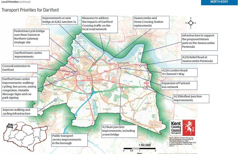
Transport Background Paper September 2021

Contents
INTRODUCTION .................................................................................................................... 2
PART 1: APPLICABLE CONTEXT ......................................................................................... 3
   National Policy..................................................................................................................... 3
   Dartford Local Plan Publication document .......................................................................... 4
   Kent County, and north Kent policy and partnerships ......................................................... 5
   Current Transport Situation in Dartford ............................................................................... 7
PART 2: EXISTING TRANSPORT ASSESSMENT EVIDENCE........................................... 10
   About Transport Assessments in Dartford ........................................................................ 10
   Proposed Lower Thames Crossing ................................................................................... 10
   Dartford Town Centre Transport Modelling ....................................................................... 12
   Ebbsfleet Development Corporation Transport Modelling ................................................. 14
PART 3: DARTFORD LOCAL PLAN STRATEGIC TRANSPORT MODELLING PROGRESS
.............................................................................................................................................. 16
   Local Plan Strategic Modelling Background ...................................................................... 16
   Stage 1 - Base Year Model ............................................................................................... 17
   Stage 2 - Forecast Baseline Report .................................................................................. 18
   Stage 3 – Local Plan Option Testing ................................................................................. 20
PART 4: FINDINGS & NEXT STEPS ................................................................................... 24

                                                                       1
DBC Planning Policy Team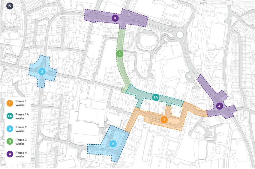
Transport Background Paper September 2021

                                     INTRODUCTION

   I.   This paper sets out the Council’s approach to ensuring that appropriate planning policy
        and mitigations are identified and planned, to respond to the current and new
        development in Dartford’s proposed Local Plan to 2037, in accordance with national
        planning policy.

 II.    It provides an overview of the key information contained in various technical
        documents and studies that have assisted the Council in defining the approach to
        transport management and mitigation proposed in the Plan. The report includes;
           •   outline of national policy and guidance and overview of draft Local Plan growth
               proposals –quantum, development types and broad locations
           •   current circumstances with regard to the highways network in Dartford and
               sustainable travel provision
           •   explanation of key existing transport impact assessments of future
               development
           •   Local Plan strategic transport assessment: an account of modelling and liaison/
               collaboration with partners- account of activity so far.

 III.   A Local Plan transport assessment is an important piece of evidence to assess the
        transport implications of the strategic spatial strategy, and provide guidance to the
        proposed policy framework. Details of the strategic transport modelling for the Local
        Plan are set out in section 3 below. However, it should be noted that there are a
        number of other recent transport assessments that have been undertaken in Dartford,
        including for very large and detailed specific development proposals (i.e. planning
        applications), which provide additional information and an understanding of the future
        capacity and issues arising on both the strategic (SRN) and local road (LRN) network
        in Dartford Borough. In some cases these assessments have led to identification of
        longer term mitigations. This evidence has all informed the Dartford Local Plan 2021.

IV.     Reference is made throughout the report to National Highways (NH) (formerly
        Highways England), as the strategic highway authority, and Kent Highways (KH) as
        the local transport authority. Together these bodies have responsibility for the road
        network within Dartford Borough

 V.     The paper firstly outlines the applicable policy and transport network context (Part 1).
        Part 2 sets out existing highway assessment evidence, followed by full explanation of
        the current strategic modelling/ assessment project (Part 3). The final part of the paper
        presents an outline of findings and next steps.

VI.     The Paper is supported by several reports covering stages of the Local Plan Strategic
        Modelling assessment produced by the consultants (Stantec) which must be read
        alongside this background paper.

                                               2
DBC Planning Policy Team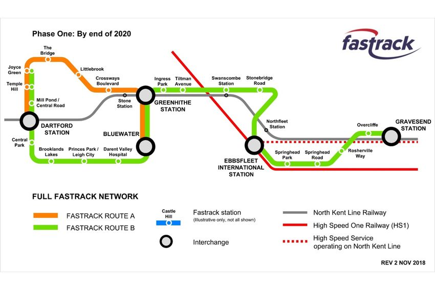
Transport Background Paper September 2021

                         PART 1: APPLICABLE CONTEXT

1.0    This part of the study outlines key policy and local transport issues, including how
Dartford proposes to address these issues in the new Local Plan.

National Policy
1.1     The primary aim of National Planning Policy Framework’s (NPPF, July 2021) is to
achieve future sustainable development. National transport policies contribute to the
achievement of all of the three overarching objectives of NPPF – a strong and responsive
economy, vibrant and healthy communities, protecting and enhancing natural, built and
historic environment.
1.2    Section 9 of NPPF is wholly focused on Promoting Sustainable Transport. Paragraph
104 says that the ‘Transport issues should be considered from the earliest stages of plan-
making and development proposals’, so that; the potential impacts of development on
transport networks can be addressed and opportunities to promote walking, cycling and public
transport use are identified and pursued amongst other outcomes.

1.3   Paragraph 105 states that significant development should be focused on locations
which are or can be made sustainable, through limiting the need to travel and offering a
genuine choice of transport modes.

1.4     Paragraph 106 advises that planning policies should;
   a) support an appropriate mix of uses across an area, and within larger sites, to minimise
      the number and length of journeys;
   b) be prepared with the active involvement of highways authorities, other transport
      providers and neighbouring councils, so that strategies and investment for supporting
      sustainable transport and development patterns are aligned;
   c) identify and protect sites and routes which could be critical in developing infrastructure
      to widen transport choice;
   d) provide for attractive and well-designed high quality walking and cycling networks with
      supporting facilities; and
   e) provide for any large scale transport facilities that need to be located in the area, and
      the infrastructure and wider development required to support their operation, expansion
      and contribution to the wider economy; and

1.5     Paragraphs 107 and 108 set out the considerations to be taken into account when
setting local parking standards and advises that maximum parking standards should be set
only where justified with regard to the situation of the local road network or with regard to the
type of development/locations, e.g. Town centres.

1.6    Paragraphs 110 to 113 set out the types of considerations required in allocating
development or assessing specific development proposals including the take up of
opportunities to promote sustainable transport, and that any significant impacts on the
transport network (capacity, congestion or highway safety) can be cost effectively mitigated to
an acceptable degree.

1.7     Paragraph 111 states that development should only be prevented or refused on
highways grounds if there would be an unacceptable impact on highway safety, or the residual
cumulative impacts on the road network would be severe. Developments that will generate
significant amounts of movements should provide a travel plan, and applications supported by
an appropriate review of transport impacts.

                                               3
DBC Planning Policy Team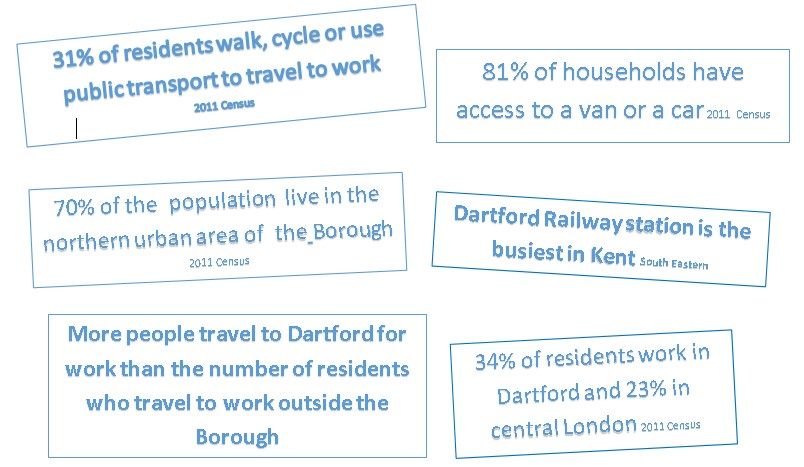
Transport Background Paper September 2021

1.8     The advice in Planning Practice Guidance (PPG) supporting the NPPF is also relevant.
In particular it highlights the importance of an assessment of transport implications to enable
a robust evidence base to support the preparation of the Plan. Assessments should take into
account the existing situation, forecast future trips by mode and cumulative impact. Transport
evidence should identify the opportunities for encouraging a shift to more sustainable transport
usage, reduce demand for travel and highlight infrastructure requirements to be incorporated
in spending plans. Guidance is provided on technical aspects of transport assessment for
Local Plans, including consideration of scenarios where there are options which would impact
travel patterns in the future.

Guidance refers to ‘The Strategic Road Network and the Delivery of Sustainable Development
– DfT Circular 2013’.

1.9    The Circular explains how National Highways (NH) will engage with the planning
system and how it will continue to act as a management and delivery partner for the strategic
road network (SRN). NH seeks to make the most efficient use of the limited available capacity
on the SRN and will engage with the Local Plan process to reduce the potential for congestion
on the SRN and achieve a pattern of development that will not compromise its operation. In
developing the evidence base, NH will work with the planning authority to understand the
transport implications of development options, including the ability of junctions to
accommodate forecast flows. Assessments should be carried out in line with guidance or on
a basis otherwise agreed with NH.

Dartford Local Plan Publication document
1.10 The new Local Plan will replace Dartford’s existing Core Strategy 2011 and
Development Policies Plan 2017. Notably, the new plan will look towards the 2030s but
maintain several principal features of the overall growth strategy and priorities established
through these existing Plans. This includes a focus on plan-led urban development, with land
identified at locations close to good public transport services, and clear criteria to resist
unplanned additional “windfall” housing (in order to avoid adverse infrastructure impacts).
1.11 Proposals in the Local Plan that are likely to result/influence transport impact on the
highways network and local area are;
   • An average of 790 new homes per annum to be built (a substantial proportion, already
     having planning consent).
   • A target for 80% of new homes to be built on brownfield land.
   • Dartford Town Centre (renewal of existing uses) and Ebbsfleet Garden City are identified
     as being the main areas of focus for future new development. This is accompanied by
     four specific land allocations within these areas some of which have historic permission.
   • Other broad site locations within these areas are also identified in case land that is
     currently unavailable comes forward in a suitable form, with policy provided to guide
     future development. One of these is in Central Dartford surrounding the railway station.
     A limited part of Swanscombe Peninsula is identified as a potential broad area for
     relatively low intensity development. (The Plan does not propose the delivery of the
     London Resort as part of the growth strategy, however, it notes that if the proposal was
     to be approved through the Nationally Significant Infrastructure Projects (NSIP) process
     and delivery of the first phase was to take place, this would trigger a review of the need
     for an update of the Local Plan).
   • No residential or commercial development is planned to take place in Dartford’s Green
     Belt.
   • Approximately 22,000sqm per annum of new commercial, business and services uses,
     and community and learning uses (including offices, health facilities and schools); and

                                               4
DBC Planning Policy Team
Transport Background Paper September 2021
approximately 25,000sqm per annum of new industrial/distribution premises. By 2032,
approximately 8-16,000 additional jobs generated from planned new development
primarily at existing identified employment areas with some strategic commercial
development at Dartford town centre and Ebbsfleet Central.
• By 2027, approximately 20,000sqm of retail floor space. This can be achieved through
existing planning permissions. Primarily focused at Dartford Town Centre (renewal),
new centres in Ebbsfleet Garden City, and some at Bluewater regional shopping centre
(with planning consent)
1.12 Transport focused policy includes:
• Substantial support within strategic and development policies for continued priority for
Fastrack (bus rapid transit) and future development of the network, potential
enhancement of rail services and potential for new stations, new and improved cycling
and walking infrastructure including a focus on interchanges.
• Applicable development transport policies are not proposed to change substantially from
those adopted in the Development Management Policies Plan 2017. A variety of policy
requirements are identified to ensure appropriate management of highway impact and
opportunities for sustainable travel be provided through new development. The policies
include;
o the design of sites to ensure the provision of a good quality cycling/walking
environment;
o access to public transport services;
o a requirement for trip generating development to be supported by a travel plan
incorporating longer term monitoring of measures;
o a requirement for any forecast off-site transport impacts to be addressed; and
o a requirement to consider the feasibility of river transportation at applicable sites.
1.13 Sections 2 to 4 of the Local Plan form the heart of the development strategy, with
Borough-wide strategic objectives (policies S1-S4) and provisions for the growth of Central
Dartford (policies D1-D7) and Ebbsfleet & Swanscombe (policies E1-E6). Development
management policies M16 and M17 focus on transport sustainable travel related issues.
Kent County, and north Kent policy and partnerships
1.14 With Kent County Council (KH) as the local highway authority for Dartford, this outlines
the Kent/ sub-regional level context. Dartford also works with a range of other transport
bodies, particularly on specific projects for north Kent.
Local Transport Plan 4: Delivering Growth without Gridlock 2016 to 2031 (Kent County
Council)
1.15 The Local Transport Plan (LTP) identifies the transport priorities for Kent over a fifteen
year period. It sets policies to deliver strategic outcomes, the level of investment required in
the County to support growth, and contains implementation plans and the approach to
prioritising funding.
1.16 Five overarching policies are identified to achieve;
• Economic growth and minimise congestion
• Affordable and accessible door to door journeys
• Safer Travel
• Reduced impact and enhance environment
• Promote active travel choices to encourage good health
5
DBC Planning Policy TeamTransport Background Paper September 2021
1.17 Focusing on aspects of the plan that are particularly pertinent to Dartford, the LTP
considers the transport actions required to enable growth in the Thames Estuary, these
include various strategic highways schemes, improved rail services and an expanded
Fastrack network. Focusing on Dartford the LTP sets out the following priorities; 1
1.18 These priorities are reflected in the draft Local Plan and other applicable documents
such as the Infrastructure Delivery Plan and the Dartford Sustainable Transport Strategy. A
number of the schemes/projects are already in progress.
Long term transport strategy and partnership working in North Kent
1.19 There has been long term collaboration between strategic stakeholders in the North
Kent area to address highways issues associated with increased level of trips through
development growth. Collaboration continues, albeit, through new and evolving groupings and
strategic documents.
1.20 A Kent Thameside transport model undertaken by local partners prior to 2008, formed
the basis for the thrust of policies in the Core Strategy 2011. The Plan notes that ‘the Council
working with its partners, Gravesham Borough Council, Highways England (now National
Highways) and Kent County Council has identified a programme of transport schemes, over
and above sustainable land use and transport policies, to address the transport impacts of
proposed growth’. The programme is referred to as the Strategic Transport Infrastructure
Programme (STIP).
1.21 Some STIP projects have been completed, with others in construction, design or in
early scoping stages. The programme and partnership continues with in addition, the Ebbsfleet
Development Corporation (EDC), as the development forecast on which the programme was
1
Kent County Council Local Transport Plan 2016 -31 pp. 35
6
DBC Planning Policy TeamTransport Background Paper September 2021
based, remains relevant at this point; mitigating large scale development still underway such
as Ebbsfleet Garden City.
1.22 The Council works closely with the Ebbsfleet Development Corporation (EDC), which
was formed in 2015 with development management and regeneration responsibilities for the
Ebbsfleet Garden City. However, Local Plans by Dartford and Gravesham councils set
planning strategy and, together with Kent County Council Minerals & Waste Plan, make up
the statutory development plan under which the EDC operates.
1.23 The EDC’s function is to facilitate delivery of Ebbsfleet Garden City which lies largely
within Dartford Borough. Provision of opportunities to encourage an uplift in sustainable travel
is a key focus for the EDC, and is featured in ongoing master planning for the Garden City.
1.24 Partnership working also continues to achieve and plan for an increased proportion of
trips to be made by sustainable modes in the North Kent area. Schemes include the Fastrack
(Bus Rapid Transit) services, new cycling/walking infrastructure and more recent partnerships
include:
• a joint project since 2015 on enhanced connectivity from Abbey Wood to Ebbsfleet
through the extension of Elizabeth Line (Crossrail) services
(https://www.abbeywood2ebbsfleet.com/)
• Transport for the South East, established in 2017
(https://transportforthesoutheast.org.uk), and
• A North Kent Sustainable Transport officers group.
Current Transport Situation in Dartford
1.25 Taking into account the 2011 Census and the location of new development since that
time, over 70% of the population live to the north of the A2 within the principal urban areas in
the Borough.
1.26 In 2011, around a third of the population used sustainable transport to travel to work
and a similar proportion worked within the Borough. In addition 23% of the population worked
in central/inner London which is a key reason for Dartford railway station being the busiest in
Kent. However, the number of residents who travel to work locations outside the Borough is
outweighed by the number of people travelling into Dartford for employment purposes (net in-
commuting).
1.27 Some of these key determinants are illustrated below:
7
DBC Planning Policy TeamTransport Background Paper September 2021
1.28 The Borough is traversed by two strategic highway routes. The A2(T) London to Dover
and M25/Dartford Crossing approach (London Outer Orbital). A number of key east-
west/north-east local roads add to the highway network across the Borough.
1.29 Two railway lines that are part of the network of railway lines radiating from London
into the South-East region, serve the Borough with a number of stations available, with in
addition the HS1 line at Ebbsfleet, providing access to international and domestic hi-speed
train services.
1.30 Fastrack (Bus Rapid Transit) services were introduced in Dartford and Gravesham in
2006 and presently provides two routes linking new developments with employment areas,
town centres and stations, as shown below:
1.31 Fastrack complements a network of other privately operated bus services to
settlements across Dartford also serving outer London and parts of North Kent.
1.32 National Cycle Route 1 and 125 run through the Borough on a mix of segregated and
on-street cycle tracks. New and enhanced segregated pedestrian and cycle routes have been
provided in some areas by Kent Highways (KH) and through new development provision, with
more in the pipeline, including provision by National Highways (NH) at the A2 Bean &
Ebbsfleet Junction Improvements currently under construction.
Congestion and resilience
1.33 The current Dartford Crossing provides the only road link to the east of London,
between Kent/continental Europe, and the Midlands and North of England.
1.34 In recent times, the capacity of the crossing is often exceeded for large periods of the
day. Due to the large amount of international, national and local traffic using the crossing this
often causes queuing on the approach to the tunnels that impacts on Junction 1A(A282). The
congestion can then extend to impact on Junction 1b and Junction 2 (A2 interchange)
particularly when accidents or incidents occur. On these occasions (which take place on
multiple occasions in any given year), it is not unusual for the local road network in the area
to become congested especially around the junctions to the approach roads.
8
DBC Planning Policy TeamTransport Background Paper September 2021
1.35 Significant incidents can result in congestion taking a considerable time to return to
normal levels. Whilst congestion also often occurs on the A2 (as one of London’s principal
radial routes), particularly due to incidents or peak hour use, the impacts on the local road
network are less pronounced. However, major delays on either strategic route, can lead to
significantly increased local traffic due to drivers seeking alternative routes.
1.36 Whilst there are some localised congestion’ hotspots’, it is issues arising from Dartford
Crossing described above, that are of particular significance to the smooth flowing of the road
network in the north area of Dartford. These issues have resulted in ongoing liaison and on-
going partnership working between the Council, NH and KH to seek mitigations and resolve
causes of congestion on both the strategic and local road network.
9
DBC Planning Policy TeamTransport Background Paper September 2021
PART 2: EXISTING TRANSPORT ASSESSMENT EVIDENCE
2.0 This part of the topic paper features recent area and specific transport assessments of
proposals with potential to impact known areas of sensitivity on the Dartford Network. Together
these provide an up to date detailed existing base of evidence on the functioning of the
Borough’s highway network and impact of new development.
About Transport Assessments in Dartford
2.1 Relevant transport assessments undertaken in the Borough include;
• National Highways (NH) strategic transport modelling to support the proposal for a
new Lower Thames Crossing east of Gravesend;
• A focused transport assessment of Dartford Town Centre to assess options for a
strategic improvement scheme and additionally to provide a forecasting tool for future
development proposals;
• NH modelling to support the application for a road order for the A2 Bean & Ebbsfleet
Junction Improvement scheme (under construction);
• Detailed modelling to support option assessment for improvements to Junction 1A;
• Transport assessments at Ebbsfleet Garden City; and
• Recent site specific transport assessments to support the determination of large scale
development proposals in areas of known highway sensitivity. Some of these are
located in the vicinity of Junction 1a of the Dartford Tunnel Approach, and have
considered impacts on the SRN as well as localised network impacts.
2.2 Further detail is provided below on some of the transport assessments and outcomes
that are most applicable to understanding Local Plan impacts.
2.3 In addition to the assessments above, KH has started developing a Kent-wide strategic
transport model, which includes consideration of the contribution of public transport.
Unfortunately, the programme for the development of the Kent model had not begun when the
Council were embarking on the Local Plan transport assessment.
2.4 The need for Dartford to undertake local plan transport assessment based on an
alternative modelling approach in advance of the development of the County strategic model,
was considered and acknowledged by KH officers at an early stage of the Dartford local plan
timetable.
Proposed Lower Thames Crossing (LTC)
2.5 Consideration of a proposal for a new Lower Thames Crossing began with public
consultation on potential locations in 2013. Further more detailed consultations focused on
refining location options, and variants, design and construction matters have followed, with a
supplementary consultation taking place in the summer of 2020. The most recent consultation
on the community impacts of the proposed schemed closed on 8 September 2021.
2.6 Dartford Borough Council has consistently supported a crossing scheme in a different
location to the current crossing, particularly as it is likely to ease congestion and provide
resilience at Dartford and reduce traffic flows on the A2 to the east of the existing crossing and
within the vicinity of Ebbsfleet. It is for this reason that the transport assessment impact
findings of the scheme are of particular interest to Dartford.
10
DBC Planning Policy TeamTransport Background Paper September 2021
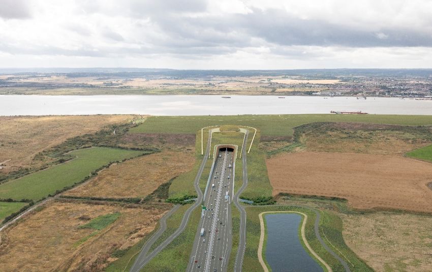
Artists Impression of the northbound route of the proposed Lower Thames Crossing Route (NH website)
2.7 Extensive assessments including transport, have supported various stages of
refinement of the scheme. Ongoing evaluation and public consultation feedback resulted in
NH recommending a bored tunnel east of Gravesend. It is this scheme that is now being taken
forward for determination through the Nationally Significant Infrastructure Project (NSIP)
process. National Highways submitted an application for a Development Consent Order in
October 2020 but this was subsequently withdrawn. NH is currently refining the proposal in
advance and working on further evidence before re-submitting its DCO application. A date for
this re-submission has yet to be finalised.
2.8 Public consultation on detailed proposals of the scheme was undertaken at the end of
2018. This was supported by an updated transport assessment, based on a strategic area
wide model which included eastern areas of Greater London. This is called the Lower Thames
Area Transport Model (LTAM), formulated by Highways England’s Lower Thames Crossing
team.
2.9 Overall, the transport modelling predicted that in the future there would be a reduction
in passenger car units at peak hours at the Dartford Crossing compared to the continuation of
the existing situation without a new lower river crossing.
2.10 Following statutory consultation the Lower Thames Area Model (LTAM), was updated
to a supplementary consultation version in early 2020, to support further revision to proposed
design in response to the 2018 consultation. Whilst the changes that occurred were primarily
to reflect changes to junctions and approaches to the new crossing (outside of the Dartford
area), other updates included updating local development details and heavy goods vehicle
numbers.
2.11 The developments included within LTAM are shown in its ‘Uncertainty Log’, these
include large scale sites with planning consent, submitted planning applications or those
identified within an adopted plan. The information was supplied by local authorities and
included forecasts in Dartford’s Core Strategy.
2.12 Updated assumptions resulted in some change to the 2018 predicted impacts on parts
of Dartford’s network to that shown in the consultation version, however, overall the traffic
impact of the LTC scheme over the whole area was similar.
11
DBC Planning Policy TeamTransport Background Paper September 2021
2.13 LTAM is a SATURN 2 strategic transport model and has been based on various traffic
data and journey patterns derived from mobile phone analysis. The model uses a peak hour
assessment that is consistent with peak hours on the Strategic Road Network (SRN) but not
the Local Road Network (LRN).
2.14 Forecasts have taken into account Department for Transport forecasts for traffic growth
in the South East up to the opening and design year (2042) with adjustments made for local
new development identified through the planning system. The model has been used to predict
future traffic journeys, taking into account how people will react to changes in the time and
cost of journeys and subsequent route choices, with and without the new crossing in operation.
2.15 Whilst confirming that it would continue to work with HE after the post-consultation
stage, Kent County Council noted in a previous consultation response that the model does not
contain sufficient validation points on the LRN which results in the model being unsuitable to
reasonably assess impacts on local roads and further validation with traffic counts on the LRN
should be undertaken. These issues were considered and addressed in Dartford’s Local Plan
Transport Assessment and are set out below.
2.16 During the statutory consultation phase of the project, the LTC team presented details
of the assumptions underlying LTAM to local authority officers and subsequently offered local
authorities a ‘cookie cutter’ extract of their model for each local authority area. It was
suggested that this may provide some useful modelling evidence for local planning authorities.
For Dartford, the cookie cutter section also included Gravesham local authority area.
Additional information is provided in Dartford’s Local Plan Transport Assessment Stage 1
report.
2.17 Taking into account the considerable technical work undertaken and that the model
had incorporated most of the development forecast by the Core Strategy, which has continued
into the forecasts of the new Local Plan; DBC entered a legal agreement in early 2019 with
NH to procure and use the Dartford cordon of LTAM. This followed discussion with KH, and
high level input from experienced consultants regarding the use of the model to support the
Dartford Local Plan.
2.18 The model provides some understanding of LRN forecast trips but was primarily
focused on local links to the SRN. This had been taken into account in the methodology of the
Local Plan transport assessment set out in section 3 below, with further detail provided in the
Dartford Transport Assessment Stage 1 Report.
Dartford Town Centre Transport Modelling
2.19 A comprehensive project of highway improvements at Dartford Town Centre was
identified at an early stage of the North Kent transport strategy, and a project identified in the
STIP programme.
2.20 Early work commenced in October 2016 with the scope of the project and phasing
clarified before formal commencement of the project in August 2018. It incorporates highways,
junction and additional improvements in areas that are primarily pedestrian, but may result in
transport impacts. A primary focus of the Town Centre project is to enable an integrated
pattern of travel and transport to support recent development built and future planned
2
Saturn simulation and assignment software used for analysis of larger networks and major infrastructure
highway proposals plus other functions
12
DBC Planning Policy TeamTransport Background Paper September 2021
development in and around the town centre in its design. A phased approach has been
adopted as shown below:
Dartford Town Centre – phased improvement project plan:
2.21 At this point, Phase 1 of the project has been completed incorporating realignment of
the ring road, re-routing of some bus services and significant new public realm.
• Phase 1a commenced in May 2021 comprising of further public realm improvements
along the High Street;
• A contract has been awarded for Phase 2 and this is due to commence later this year
comprising junction improvements at two key gateways to the town centre, with the
introduction of the latest traffic signal technology, and further public realm
improvements.
• Phases 3 and 4 are being designed with construction scheduled for 2022/23 and
2023/24.
2.22 To assist in the identification of improvement schemes and testing of early design
proposals for each phase, a Vissim 3 transport model of Dartford Town Centre and environs
was commissioned and produced. The model provides a 2027 forecast and was updated in
early 2019 (pre-Covid lockdown) to recalibrate the base to observed flows.
2.23 The forecast assumptions and formulation of the Vissim model and ongoing approach
to its use for the town centre scheme included regular input from KH. Additionally, the model
has also recently been used to inform an assessment of transport impacts of a large mixed
use development application in the heart of the town centre, which has subsequently been
given outline consent. The use of the model for the transport assessment also informed the
highway authority’s comments on the planning application.
2.24 This transport assessment and ongoing testing of schemes using the model, have
provided an iterative basis of reviewing the ongoing scope and design of highways
improvements in the town centre. For example, early proposals for Phase 2 of the town centre
3
Vissim is a multi-modal traffic flow simulation software package
13
DBC Planning Policy TeamTransport Background Paper September 2021
scheme for the ring road to become two way, were revised after the model indicated that this
would result in a worsening of traffic congestion in the morning peak, and the transport
assessment of the development proposal indicated that Phase 4 of the town centre scheme
should be slightly expanded to incorporate some further changes to adjoining local roads, to
assist vehicles leaving a new car park.
2.25 It is envisaged that the town centre Vissim model will be used to support the testing of
impacts of the designs for the further phases of the town centre scheme and available to be
used for assessing the transport impacts of future development in the town centre.
2.26 This is particularly useful taking account that the Local Plan focuses future
development on this area.
Ebbsfleet Development Corporation Transport Modelling
2.27 In the east of the Borough, Ebbsfleet Garden City is the other main area of focus for
future growth identified in the Local Plan.
2.28 The sites within the Garden City were identified in the early stages of Thames/North
Kent growth strategies as having potential for significant residential and commercial
development accompanied by new infrastructure, and this featured in the adopted Dartford
Core Strategy.
2.29 Outline planning consents were granted a number of years ago, some of which have
been taken forward to master planning and onward phased detailed consents. A substantial
amount of new homes and supporting infrastructure has been delivered over the last few years
particularly in the Whitecliffe area.
2.30 The outline consents were supported by transport impact assessments and all
consents contain strong measures to reduce car use, identification of specific junction
improvements (included within the STIP programme), s106 contributions and additionally an
ongoing monitoring and mitigation framework. Both NH and KH were and are key agencies
involved in this framework approach.
2.31 The EDC in tandem with its development management function has developed
strategies for place making and sustainable communities at Ebbsfleet which are set out in the
draft Local Plan. This has included a focus on sustainable and active travel. Whilst there has
not been a need to undertake further transport assessment to support development in the
area, as ongoing development already has planning consent, focused public transport
modelling has been taken forward by KH in conjunction with the EDC.
2.32 Vissim modelling was undertaken during 2018 to particularly consider highways
hotspots with particular focus on Fastrack. The model included the highways network current
and planned within Ebbsfleet and a small area in the vicinity. The later stages of the project
focused on some of the highway congestion’ hotspots’ identified through earlier modelling.
2.33 Further Vissim microsimulation, was commissioned in 2019 by KH, for a large area of
the Fastrack network and has been used in conjunction with testing potential journey times of
proposals for specific Fastrack enhancement projects at Ebbsfleet and beyond.
2.34 The model was based on 2018 observed flows and compared with and without future
Fastrack improvement scenario, taking into account highways changes expected in the future.
The work included modelling at Junction 1b of the Dartford Tunnel Approach together with
other pinch-points affecting Fastrack service resilience on the highway network.
14
DBC Planning Policy TeamTransport Background Paper September 2021
2.35 The findings were used to identify schemes worthy of more detailed analysis and
design some of which are being taken forward in partnership with EDC.
2.36 Modelling indicated that at Junction 1b, Fastrack timing improvement only occurs if an
additional bridge structure was provided. However, the cost of such a scheme did not warrant
this improvement being taken forward.
2.37 The EDC has indicated that a new outline application is likely to be submitted for
substantial development at its Ebbsfleet Central site, the site surrounding Ebbsfleet
International Station, which is supported in principle in the Local Plan.
2.38 This will result in a new transport assessment of impacts being undertaken, which will
take into account Local Plan forecast development to identify cumulative transport
implications.
London Resort
2.39 Within the EDC area, at Swanscombe Peninsula, proposals for an entertainment resort
were submitted as an NSIP application on 31 December 2020. This follows several years of
uncertainty as to if/when it would be submitted.
2.40 Extremely limited information on the transport implications of the scheme were made
available to the Council. The developer has not sought a site allocation in the Dartford Local
Plan, instead choosing to put forward proposals as an NSIP. It, therefore, has not been a
feature of Dartford strategic transport modelling outputs.
2.41 The NSIP process has been delayed with London Resort being required to provide
further information on a range of topics including its transport assessment. London Resort
has also had to consider its response to the declaration of a Site of Special Scientific Interest
by Natural England that affects most of its site as well as covering the Ebbsfleet Valley.
2.42 The Dartford Local Plan Publication 2021 proposes a review of the need to amend the
Local Plan should the London Resort proposals gain development consent and progresses to
a start in construction.
15
DBC Planning Policy TeamTransport Background Paper September 2021
PART 3: DARTFORD LOCAL PLAN STRATEGIC TRANSPORT
MODELLING PROGRESS
3.0 This central part of the report outlines the rationale, structure, and outline of
engagement with stakeholders (notably highway authorities) undertaken for Local Plan
transport modelling; plus highlighting key outputs so far.
Local Plan Strategic Modelling Background
3.1 Whilst much of the forecast development identified by the new Local Plan has planning
consent with the transport implications set out in various transport assessments and
incorporated into long term partnership working, it is essential, in accordance with national
policy, that a review of transport implications of the Local Plan is undertaken.
3.2 In spring 2019, the Council commenced initial engagement with potential transport
consultants, with experience in strategic transport modelling regarding a project to provide
evidence on the transport implications of a new Local Plan. Key points identified for testing
and evidence support by the Council at this stage were;
• A likely urban focussed strategy, e.g. central area regeneration and better/more
intensive use of land (rather than alternative spatial location options such as greenfield
‘urban extensions’)
• Implications of strong demand for business floor space in the Borough
• Evidence to support a District transport strategy to minimise the impact of forecast
development on the transport network
3.3 Overall, these points are still the key focus for the Dartford Local Plan Publication 2021.
3.4 A Dartford strategic transport model was required to support Local Plan transport
impact evidence along with other sources. However, as set out in section 2 there are other
robust information sources in existence that provide an understanding of the transport
implications of Local Plan strategy and the Dartford context.
3.5 After a competitive procurement process, Stantec (formerly Peter Brett Associates)
was appointed to undertake the commission. The team had considerable experience of
transport assessments, modelling and had been involved in a number of projects in the local
area.
3.6 The key stages of the project at its commencement were;
Stage 1 – Review and produce a 2019 base model
Stage 2 – Develop a ‘without Local Plan’ forecast model
Stage 3 – Testing of a Local Plan Preferred Option and initial variants for mode
shift
Stage 4 – Identification of mitigations
3.7 A Dartford Cordon of the Lower Thames Area Model (DCLTAM) was provided to the
consultants by the Lower Thames Crossing team under a legal agreement.
Option Testing
3.8 It was envisaged at this early stage that there may be a need for some testing of growth
options to inform the Plan.
3.9 During the formulation of the preferred Local Plan growth strategy, it was clear that a
substantial proportion of future development in the Borough already had planning consent.
16
DBC Planning Policy TeamTransport Background Paper September 2021
3.10 Consideration of development options was achieved through considering the
Sustainability Appraisal, Strategic Housing Land Availability Assessment and Economic Land
Report, and responses to the Regulation 18 Preferred Options Consultation stage of the Plan
in January 2020.
3.11 Testing of mode shift scenarios remains an important part of the project.
Activities completed
3.12 Substantial progress has been made, working with partners resulting in the completion
of Stages 1 to 3 as set out below. The key areas of work for each phase, liaison with highways
partners, issues arising and a summary of outputs is set out below. The following commentary
also sets out the changes to the project and issues arising during the project that have
impacted on the timescale for outputs.
3.13 The following reports have been produced by the transport assessment and are
provided as part of the Local Plan Publication evidence base. These provide full details of the
work carried out.
Stage 1 – Base Year Model
Stage 2a – Forecast Year Baseline Model
Stage 2b – Reference Case Methodology
Stage 3a – Local Plan Option Testing Methodology
Stage 3b – Local Plan Option Testing Outputs
The Duty to Cooperate Statement, also published as evidence base for the Local Plan,
provides a summary of the liaison meetings held with highways partners during the course of
the Transport assessment.
Dartford highway network analysis in the Stantec Stage 1 Report
Stage 1 - Base Year Model
3.14 This stage included
• Agreement with partners on the scope and methodology of the assessment
• Enhancing some of the DCLTAM modelled network and zoning to provide a greater
local refined network for the base
• Collection of existing traffic data and calibration of the base year model with observed
flows
17
DBC Planning Policy TeamTransport Background Paper September 2021
3.15 Stantec completed much of the initial review and adjustment to DCLTAM during the
summer of 2019 followed by liaison with KH, NH and EDC during the autumn.
3.16 A meeting was held with the LTC team to ensure that the methodology being applied
to update DCLTAM to a 2019 base was technically appropriate. Overall, there was general
agreement on the base model and matrix estimation approach. The LTC team continued to
provide technical assistance, where requested by Stantec.
3.17 Based on feedback from these bodies a draft report was produced in early 2020,
however for reasons outlined under Stage 2 below an updated report was produced in
February 2021 to accompany Regulation 19 consultation of the Local Plan. The report sets
out more background on engagement, and technical detail provided on the changes and
enhancements made by Stantec to DCLTAM to produce a 2019 base model.
3.18 At this initial stage, liaison with highways partners highlighted that Dartford contained
a critical part of the SRN and that Local Plan testing should clearly identify the impact of the
Local Plan differentiating between those sites with and without consent. Ongoing liaison with
KH had identified that based on current understanding, there would be a need to alleviate
traffic congestion, and mode shift would be essential to achieving this.
3.19 Key changes made;
• Reduced DCLTAM to cover only Dartford Borough
• Change to modelled peak hours to local road network peak times
• Links added to incorporate local important routes
• St Clements Way junction scheme added to highways schemes
• Local coding changes to reflect – local speed limits, junction design
• Additional zones added to town centre to enable more detailed distribution
3.20 Updating included testing against observed flows and recent traffic assessment data
from planning applications.
3.21 The resulting 2019 base year network model will be used in conjunction with forecast
models to indicate an uplift of traffic flows for the reference year (2036), and Local Plan
scenarios to enable a comparative understanding of the impacts on the highways network.
Stage 2 - Forecast Baseline Report
3.22 The objective of this stage of the project was to produce 2036 trip matrices based on
the DCLTAM model with no Local Plan development (but including developments with
planning consent) both with and without the Lower Thames Crossing.
3.23 This enables an understanding of impacts if the LTC project was not to go ahead.
3.24 In developing a 2036 without Local Plan model Stantec undertook the following
actions;
• Interpolation from DCLTAM essentially producing a 2036 forecast from 2032 and 2042
data
• Some zone connector changes – the point where a zone loads onto the network to be
commensurate with local circumstances
• Growth comparisons with TEMPRO
• Review of future highways schemes and relevant adjustments to the DCLTAM base
• Matrices assignment
3.25 DCLTAM forecast data was assumed at the start of this stage to be a reasonable basis
for representing the forecast year scenarios. However, it became clear in reviewing the
uncertainty log (list of development incorporated into LTAM) that additional developments had
gained planning consent up to 2019 that had not been included, and that consents were not
18
DBC Planning Policy TeamTransport Background Paper September 2021
in place at 2019, for development areas anticipated in the Core Strategy, but which had been
included in the uncertainty log. Therefore there was a need for update.
3.26 Overall these changes did not result in any significant difference to development
quanta anticipated by DCLTAM although changes occurred at specific locations. These have
been required to be applied to the Local Plan updated network, described in the Stage 1 and
2 consultant reports.
3.27 Additionally, in liaison with NH traffic generation rates of specific development types
forecast in the Local Plan, were reviewed and updated in the Dartford model.
3.28 These factors resulted in a two stage process, being taken by Stantec, to produce a
Dartford Local Plan 2036 Reference Case model that continues to be based on DCLTAM.
3.29 The 2036 forecast baseline scenario modelling approach based on LTAM is provided
in the Stage 2a Report. However, details of the additional development of a more refined local
reference case incorporating changes to land use and quanta to that of DCLTAM, as outlined,
is set out in the Stage 2b Report.
3.30 Stage 2b also considers these two similar but different reference models and sets out
the framework for the derivation of a 2036 Dartford Reference Case. Taking into account the
input of highways authorities, outlined above, the Stage 2b Report;
• Considers the traffic generation parameters applied to the two reference scenarios –
with full detail of the approach to rates applied incorporated into the Stage 3 Report
• Compares the DCLTAM and refined local reference case predicted traffic generation
based on these parameters
• Taking into account these factors considers the distribution assumptions to be applied
in deriving a Dartford 2036 Reference Case
3.31 The engagement with highways authorities during autumn 2019, outlined in Stage 1
above, included discussion of the project methodology to be applied.
3.32 Further liaison and discussion followed in 2020 and a revision to early phase 1 and 2
stages has influenced the development of the reference case as indicated above. Details of
the reasoning for the revision to early work is set out in the LTC – supplementary consultation
section below.
3.33 Notwithstanding, changes to methodology, assumptions and development of a 2036
reference case outlined above, the objective of comparing Local Plan scenario testing to the
2036 Dartford Reference Case remains.
Lower Thames Crossing – supplementary consultation
3.34 As explained in section 2 above, NH updated the design of the Lower Thames
Crossing in early 2020, and this was supported by an update to LTAM - supplementary
consultation version.
3.35 New data for the DCLTAM was provided to the Council in April 2020 and it was agreed
that Stantec should conduct a high level assessment of the impact of changes to forecast
traffic levels in Dartford, with further detailed assessment undertaken, if the initial assessment
indicated this was required.
3.36 The findings of this comparison exercise indicated that the update had resulted in
significant increases to traffic numbers in Dartford for both the 2016 base and forecast year
2042. These were in critical areas of the network such as J1a, J1b, Ebbsfleet and the A2, and
north bound routing from A2 Bean Junction, only minor changes had occurred in and around
Dartford Town Centre.
19
DBC Planning Policy TeamTransport Background Paper September 2021
3.37 The LTC team confirmed to the Council, when providing the updated data, that there
would be no further update in advance of a DCO application and it was deemed appropriate
for the Dartford study to be based on the most up to date base.
3.38 Therefore it was decided that stage 1 and 2 of the transport assessment should be
refreshed and work on the remaining stages should continue.
3.39 Underlying data in the base and forecast base models was updated, and the Stage 1
and 2 reports re-issued to highways partners in October 2020. This resulted in a number of
more detailed issues being raised by NH regarding a number of technical concerns regarding
the original assumptions and methodology which NH felt may undermine the robustness of
modelling findings.
3.40 Over autumn 2020, Stantec provided responses and updates to ensure changes were
within or near to parameters acceptable to NH for Local Plan assessment purposes.
3.41 In February 2021, NH confirmed, that after reviewing further information provided for
clarification, use of the model for Local Plan forecasting and assignment was considered
acceptable.
3.42 Kent Highways, indicated continued acceptance of the proposed approach after a
presentation of the changes in autumn 2020.
3.43 The additional clarification information provided to NH has been incorporated into the
updated Stage 1, 2a and 2b Reports. Resulting changes to forecasting methodology has also
indicated a need to provide a be-spoke Dartford Reference Case based on DCLTAM. The
Stage 2b Report indicates the approach to applying matrices of vehicle movements to the two
reference models to derive a Dartford 2036 Reference Case matrix (to be used for comparison
purposes against Local Plan scenarios).
3.44 The need to update stage 1 and 2 underlying model data due to the supplementary
LTC update, the further technical clarifications for highways authorities and the emergence of
the need to create a more refined Dartford 2036 forecast Reference Case was unforeseen
and has led to significant delays to maintain robust outputs. This has impacted progress on
stage 3 of the transport assessment.
Stage 3 – Local Plan Option Testing
3.45 Stage 3 of the transport assessment derives the traffic generation arising from Local
Plan forecasts and the potential change to traffic impacts under two alternative mode share
scenarios.
3.46 These are to provide a comparison of differences in peak hour trips and distribution on
the strategic and local highway network against the Dartford Reference Case (with and without
the Lower Thames Crossing) of;
i. Local Plan forecast development – locations, quanta and land use (without planning
consent)
ii. Based on the above, two different scenarios anticipating higher levels of sustainable
trips than usually assumed in Local Plan modelling
3.47 These project activities and outputs provide the key tasks of Stage 3. However, due
to the delays set out above during stage 2, the modelling of each scenario was still underway
into February 2021 when the first (Regulation 19) Local Plan Publication was published.
Whilst acknowledging the importance of strategic testing of transport impacts of growth
proposals to support the Local Plan, the Council, taking into account potential findings and
other local evidence, progressed to Regulation 19 Local Plan Publication based on rationale
set out below.
20
DBC Planning Policy TeamTransport Background Paper September 2021
3.48 During 2020, Stantec provided draft methodology and assumptions to be applied in
deriving the Local Plan modelling scenarios, to the highways authorities and EDC. This was
primarily based on local evidence. The proposed approach has evolved in response to
stakeholder input, and the Stage 3 Report was provided as part of the evidences base for this
first Regulation 19 Local Plan Publication.
3.49 NH and KH both indicated that the approaches proposed were acceptable for
assessing the transport impact of the Local Plan.
3.50 The Stage 3a Report set out:
• The traffic generation parameters for various land uses – approach to identification of
the TRICS 4 data to be applied and application of urban and suburban sites.
• Mode share of trip generation for various uses – review of relevant 2011 census mode,
origin and destination findings, and TRICS mode share data
• Mode share shift variant scenarios to be assessed – details of local and national policy
ambition, evidence, future trends and identification of two mode share variants. This
includes the methodology to be applied to differentiate areas/trips that have most
potential to achieve higher levels of sustainable trips
• Distribution assumptions to be applied – application of a blend of 2011 journey to work
data with recent mobile phone data for the distribution of Local Plan traffic generation.
Considers internal and internal/external – origin and destination trips
Local Plan Transport Assessment Results
3.51 During the course of the first Regulation 19 Local Plan Publication, Natural England
declared a Site of Special Scientific Interest covering the Swanscombe Peninsula and a large
part of the Ebbsfleet Valley. This was judged to have a material impact on the Local Plan
particularly as it potentially affects the scale and disposition of planned development in the
Ebbsfleet Central area one of the key areas for development within the Local Plan. The
decision was, therefore, taken to review the Local Plan and prepare a second Regulation 19
Local Plan Publication. This preparation has led to the Dartford Local Plan Publication
(September 2021).
3.52 This provided the opportunity to complete the transport assessment for the Local Plan
Preferred Option (Stage 3) and carry out further engagement of the highways authorities
regarding mitigation of the transport impacts.
3.53 In July 2021, NH raised as an issue that the level of development within the Dartford
Reference Case was higher than the level of development in the Local Plan Preferred Option
with the consequences that, across a large part of the highway network in Dartford, there was
little or no impact a result of the Local Plan development. It was concluded that the primary
issue was the level of development that had been included in the Dartford Reference Case.
3.54 In considering the potential transport impact of the Local Plan it is important to
emphasise the context of growth identified. The Local Plan forecasts indicate:
1. The majority of future development identified has planning consent and most
feature in the LTAM reference baseline;
2. A reduced scale of delivery of some consented land uses forecast and in some
cases, particularly in the Ebbsfleet area, sites may continue to develop beyond
2036/7;
3. Large scale historic but live outline development consents at Ebbsfleet incorporate
land use maxima parameters, to provide flexibility for future master planning. At
4
TRICS is a database and data analysis system comprising a large number of transport survey records of
individual developments. The traffic generation data is used as a proxy in transport assessments of
development proposals.
21
DBC Planning Policy TeamYou can also read