Tulsa's Route 66 Master Plan
←
→
Page content transcription
If your browser does not render page correctly, please read the page content below
plan

Tulsa’s Route 66 Master Plan

plan

Adoption Information
The Executive Summary and Chapter 5 – Recommendations
were adopted by Tulsa Metropolitan Area Planning Commission
and approved by Tulsa City Council.
Effective: December 2020
For questions, contact:
  Paulina Baeza, Senior Planner
  pbaeza@incog.org
 Dennis Whitaker, Planner
 dwhitaker@incog.org
Tulsa Planning Office
2 W 2nd St., 8th Floor
Tulsa, OK 74103
918.584.7526
tulsaplanning.org
plan

Table of Contents
Acknowledgments ................................................................... 1
Executive Summary ................................................................. 4
     Introduction......................................................................................5
     Background......................................................................................5
     Purpose Statement..........................................................................7
     Vision................................................................................................7
Chapter 1 — Background......................................................... 8
     Route 66 History..............................................................................9
     Tulsa’s Previous Route 66 Master Plan (2005).......................... 10
     Other Studies and Plans............................................................... 10
     Case Study..................................................................................... 12
Chapter 2 — Existing Conditions........................................... 14
     The Evolution of Route 66............................................................ 15
     Revitalization Opportunities......................................................... 15
     Demographics............................................................................... 17
     Economic Development................................................................ 18
     Connectivity................................................................................... 19
     Culture and Recreation................................................................. 21
     Route 66 Projects......................................................................... 22
     Notable Findings........................................................................... 23
Chapter 3 — Successes.......................................................... 24                             Maps and Figures
     The Route 66 Master Plan (2005)............................................... 25                           Map 1 — Route 66 Revitalization Opportunities........................... 16
     Route 66 Corridor Districts (2005).............................................. 28                         Table 1 — Demographics................................................................ 17
     Vision 2025 Project Highlights..................................................... 29                      Table 2 — Economic Development................................................. 18
     Non-Capital Projects..................................................................... 37                Table 3 — Top Industry Sectors...................................................... 18
     Other Successes since 2005....................................................... 37                        Map 2 — Route 66 Connectivity..................................................... 20
     Additional Resources.................................................................... 37                 Table 4 — Culture & Recreation..................................................... 21
                                                                                                                 Map 3 — 2005 Corridor Districts................................................... 27
Chapter 4 — Methodology...................................................... 38                                 Map 4 — Highlighted Vision 2025 Projects................................... 30
     Methodology.................................................................................. 39
                                                                                                                 Figure 1 — Future Growth Potential and Indicators...................... 39
     Outreach Process.......................................................................... 43
                                                                                                                 Map 5 — Density of Landmarks..................................................... 40
     Prioritized Target Areas................................................................. 48
                                                                                                                 Map 6 — Density of Land Use Opportunities, and
Chapter 5 — Recommendations............................................ 52                                                  Connectivity and Housing............................................. 41
     Goal 1: Preserve 66...................................................................... 53                Map 7 — Composite Density.......................................................... 42
     Goal 2: Revitalize 66..................................................................... 55               Figure 2 — Survey Respondents by Age Group............................. 45
     Goal 3: Connect 66....................................................................... 57                Figure 3 — Survey Respondents by Zip Code Tier........................ 45
     Goal 4: Celebrate 66.................................................................... 59                 Map 8 — Survey Response............................................................. 46
     Prioritized Initiatives & Specific Route 66 Projects..................... 61                                Figure 10 — Top Strategies for Each Goal..................................... 47
     Implementation Resources.......................................................... 62                       Figure 11 — Target Area Preferences by Outreach....................... 49
                                                                                                                 Map 9 — Target Areas..................................................................... 50
plan

Acknowledgments
Tulsa Planning Office                         Plan 66 Advisory Committee                           Subject Matter Expert Interviewees
Project Lead                                  • Ken Busby, Chair, Route 66 Commission and          • Jesse Boudiette, President and Owner of
• Paulina Baeza, Senior Planner                 Chair, Route 66 Finance Committee                    Propeller Communications, Route 66 Business
                                              • Rhys Martin, Past Chair, Route 66 Commission,      • Amy Smith, Co-Owner of Soul City, Route 66
Project Team                                    and President, Oklahoma State Route 66               Business
                                                Association                                        • Amanda DeCort, Executive Director, Tulsa
• Dennis Whitaker, Planner
                                              • Brandi Ball, Executive Director, Route 66 Main       Foundation for Architecture
• Ty Simmons, Principal GIS Analyst             Street and Member, Route 66 Commission             • Rhys Martin, Chair, Route 66 Commission
• Nathan Foster, Senior Planner               • Walter Faber, Route 66 Property Owner and          • Liann Alfaro, Marketing and Planning Director,
• Emily Scott, Assistant Planner                CFO, J.D. Young                                      Tulsa Transit
• Daniel Jeffries, Senior Planner             • Jessica Jackson, Executive Director, Kendall       • Jane Ziegler, Bicycle and Pedestrian Coordinator,
                                                Whittier Main Street and Member, Route 66            INCOG
Contributors                                    Commission
                                                                                                   • Aaron Meek, Owner & Operator, M Development,
• Susan Miller, Director                      • Brian Kurtz, Executive Director, Downtown            Route 66 Business
                                                Coordinating Council
• Travis Hulse, Principal Planner
                                              • Vanessa Masucci, Vice President of Sales,
• Jed Porter, Historic Preservation Planner     VisitTulsa
• Luisa Krug, Destination District Manager    • Aaron Meeks, Route 66 business owner,
• Samiul Haque, Intern                          and Chair, Route 66 Commission Economic
                                                Development Committee
                                              • Spencer Mitchell, Mayor, Office of Economic
                                                Development
Plan 66 Sponsors and Contributors
                                              • Meredith Peebles, COO, Lobeck Taylor Family
• Tally’s Good Food Café                        Foundation, representing Route 66 Business
• Lobeck Taylor Family Foundation               Owner
• Tulsa Planning Office                       • Larry Wofford, Chair of Entrepreneurial Studies,
                                                University of Tulsa
• Route 66 Commission

1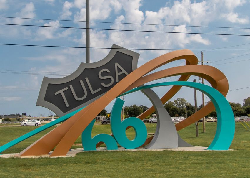
plan

Round Table Diversity Discussion                    Route 66 Commission                                  Goal Subject Matter Expert Interviews
• Tally and Angela Alame, Owners,                   • District 2 – Councilor Jeannie Cue                 Goal 1 — Preserve the Route
  Tally’s Good Food Café                            • District 3 – Councilor Christa Patrick               • Amanda DeCort, Executive Director, Tulsa
• Zechariah Harjo, Project Development              • District 4 – Councilor Kara J. McKee                   Foundation for Architecture
  Coordinator, Muscogee Creek Nation                                                                     Goal 2 — Revitalize the Route
                                                    • District 5 – Councilor Cass Fahler
• Mattie Bledsoe-Hayes, Owner,                                                                             • Aaron Meek, Owner, Group M Development
  OK Style Bar-B-Que                                • District 6 – Councilor Connie Dodson
                                                    • Ken Busby, Executive Director, Route 66 Alliance   Goal 3 — Connect the Route
• Darrell and Tamika Knox, Owner,
  Sweet Lisa’s Restaurant                           • Amanda DeCort, Executive Director,                   • Jane Ziegler, Bicycle-Pedestrian Coordinator,
                                                      Tulsa Foundation for Architecture                      INCOG
• Trent Morrow, Ziegler Art Supplies (Cherokee
  Nation Tribal member)                             • Nick Doctor, Chief of Community Development          • Liann Alfaro, Planning and Marketing Director,
                                                      and Policy, City of Tulsa                              Tulsa Transit
• Travis Owens, Director, Cultural Tourism
  & Community Relations, Cherokee Nation            • Samantha Extance, Events Coordinator,              Goal 4 — Celebrate the Route
  Business                                            Mother Road Market                                   • Jesse Boudiette, Owner, Propeller
• Geraldo Romero, Owner, Romero’s Auto Center       • Christine Hamner, Executive Director,                • Amy Smith, Artist & Entrepreneur
• Esteban Torres, Owner, Key Plus Properties          Route 66 Main Street
• Francisco Trevino, Executive Director,            • Ray Hoyt, President, VisitTulsa
                                                                                                         Photography Credits
  Casa de la Cultura                                • Jessica Jackson, Executive Director,
                                                                                                         • Daniel Jeffries, Senior Planner,
• Sharla Walker, Owner, Evelyn’s Restaurant           Kendall Whittier Main Street
                                                                                                           Tulsa Planning Office
• Larry Wofford, Davis D. Bovaird Endowed Chair     • Kian Kamas, Chief of Economic Development,
                                                                                                         • Dennis Whitaker, Planner,
  of Entrepreneurial Studies, University of Tulsa     City of Tulsa
                                                                                                           Tulsa Planning Office
• Ricco Wright, Owner, Black Wall Street Gallery    • Karen Keith, Tulsa County Commissioner,
                                                                                                         • Jessica Jackson, Executive Director,
                                                      District 2
                                                                                                           Kendall Whittier Main Street
                                                    • Luisa Krug, Destination Districts Manager,
                                                                                                         • Nathan Foster, Senior Planner,
                                                      Tulsa Planning Office
                                                                                                           Tulsa Planning Office
                                                    • Linda Fitzgerald, President, Route 66 Village
                                                                                                         • Rhys Martin, President,
                                                    • Rhys Martin, President,                              Oklahoma Route 66 Association
                                                      Oklahoma Route 66 Association
                                                                                                         • Samantha Extance, Events Coordinator,
                                                    • Julie Miner, Economic Development Planner,           Mother Road Market
                                                      INCOG
                                                    • Susan Neal, Vice President for Public Affairs,
                                                      University of Tulsa, and Executive Director of
                                                      Gilcrease Museum
                                                    • Lisa Wakefield, Owner, Jenkins & Company

                                                                                                                                                             2
plan

Route 66 Rising Sculpture at Admiral Place and Mingo Road

3
Executive Summary

       plan

                    Route 66 Historical Village Oil Derrick Replica

                                                                      4
plan

                                               Introduction                                            Background
                                               The previous Route 66 Master Plan, completed in         Voters’ approval of the Vision 2025 funding
                                               December 2005, viewed Route 66 as a corridor            package in 2003, and the creation of the Route
                                               filled with opportunity. Route 66 has international     66 Master Plan in 2005, which directed those
                                               appeal, as travelers from around the globe flock        funds earmarked for projects along Route 66,
                                               to the Route to experience a bit of American road       indicated that local residents were ready to realize
                                               trip magic, but the 2005 plan also identified a         the Route’s substantial, untapped potential by
                                               generational divide. Route 66 enthusiasts of            investing public dollars. Leaders believed public
                                               the Baby Boomer and earlier generations share           investment promoting thematic connectivity along
                                               memories of the road and recognize its place in         Tulsa’s alignments of Route 66 would attract the
                                               American heritage, but younger generations had          attention of entrepreneurs and private investment,
                                               no ties to it. During the 15 years since the original   leading to a substantial return on the public
                                               plan, several initiatives have been implemented.        investment. A revitalized corridor would become
                                               The Route has come back to life, and younger            a vibrant component of Tulsa’s overall economy,
                                               generations are fully participating in its revival.     preserve its rich heritage and elevate Tulsa’s
Route 66 Shield on the East Gateway                                                                    prominence as a destination for Route 66 tourism.
                                               Plan 66’s vision of a redeveloped Route 66 honors
                                               the history of Tulsa and caters to both Tulsans and     To accomplish the initial goal of heightening
                                               visitors. Providing for younger generations means       the recognition of Route 66, public investments
                                               combining past, present and future in the same          were planned for the years 2005-2022, bringing
                                               place. A renewed Route 66 will offer a variety of       capital projects across nearly 30 local miles
                                               experiences to people of different ages, cultures,      of Route 66. To create a platform for the next
                                               and backgrounds, while sustaining what exists           phase of enhancements and development,
    Tulsa’s 2005 Route 66 Master Plan          and encouraging economic development.                   broader recommendations for non-capital actions
    was based on an intensive program                                                                  offered further support for the development
    that pumped economic development           Plan 66 envisions the Route as a place that             and establishment of Route 66 as a vibrant
    investments through capital projects.      draws both locals and visitors. Today, Tulsa’s          commercial and residential corridor.
    Changes were made, and benefits were       30 miles of Route 66 still provide a car-centric
    reaped. Nowadays, new demands have         experience. Development patterns are shifting,          Leaders also believed that to support the Route
    originated from the process and passing    and to continue its renaissance, the corridor           long-term and encourage private investment, an
                                               needs to adapt to multiple scales, multi-modal          authentic and visible recognition of the intrinsic
    of time. A more diverse crowd must be      transportation options, and pedestrian comforts.        value of Route 66’s heritage was needed. As other
    catered and included in the evolution of   In addition, the corridor should be accessible to       commercial districts would become fully occupied,
    the route.                                 other parts of the city, connect landmarks and          perhaps sustaining higher costs, entrepreneurs
                                               destinations, and provide guests with the chance        would seek the next area to invest or reinvest;
    The focus of Plan 66 will rely on          to explore more of what Tulsa has to offer.             Route 66 would be poised for that opportunity.
    celebrating past project implementation
    along the corridor, creating non-capital   Route 66 is still largely untapped in Tulsa. Other      To support a broader partnership and framework
    infrastructure to encourage private        cities in the country have taken advantage of it        for private investment, non-capital objectives
    ventures, and supporting emerging          as an attraction; until relatively recently, Tulsa      were also developed. Conveying Route 66’s
    businesses, attractions, and future        had not taken advantage of that opportunity. With       living heritage and making it relevant to younger
    capital investment                         proper guidance, Route 66 in Tulsa will continue        generations, the Master Plan directed future
                                               to become an attractive destination for visitors        thinking toward partnerships, other funding
    Community and entrepreneurs, we            and locals; a source of employment that favors          mechanisms, an oversight commission or
    need you to partner and rise.              economic growth and opportunity creation; and a         authority, and the use of local zoning provisions to
                                               thriving landmark.                                      facilitate each phase of Route 66’s growth.

5                                                                Executive Summary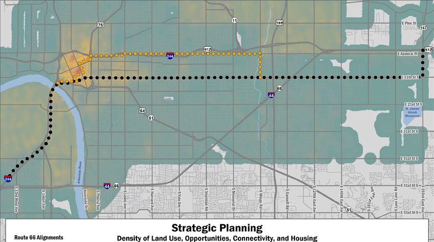
plan

Vision 2025 capital projects are nearing full implementation, with many successes, including:
• Immediately in 2003, $15,000,000 of Vision            • As theorized, four commercial districts
  2025 funds were dedicated to Route 66                   along Route 66 have emerged, two of which
  revitalization for Master Plan Capital Projects,        are official Main Street programs. New
  attracting a commitment from the National               entrepreneurs or existing businesses are
  Route 66 Federation, which held its 2004                reinvesting in buildings that were formerly
  International Route 66 Festival in Tulsa.               underutilized or vacant, land uses are
                                                          transitioning, and new construction has
• Local funds were combined with a grant of               occurred. The recent opening and dedication
  $400,000 from the Oklahoma Centennial                   of a privately-funded retail shop and kitschy
  Commission to construct Avery Centennial                space cowboy statue, Buck Atom, has seen
  Plaza, the Route 66 Skywalk, and the East               visitors from around the globe, including
  Meets West sculpture. Local businesses                                                                        Buck Atom Cosmic Curious Sculpture on 11th Street
                                                          tourists from Australia, Brazil, Canada, Croatia,
  readily incorporated the Route 66 Skywalk into          Czech Republic, Germany, Hungary, England,
  television and print media advertisements;              France, Italy, New Zealand, Poland, Spain, and
  likewise, East Meets West became the icon               Switzerland.
  of the first annual Route 66 Marathon and its
  finishers’ medals.                                    • An Executive Order by Mayor Dewey Bartlett
                                                          created a Route 66 Commission, and voters
• The Oklahoma Centennial Commission also                 have approved additional capital and non-
  provided a $400,000 grant to the Red Fork               capital funding for the Commission to
  Centennial Derrick at the Route 66 Historical           administer and for the further development of
  Village. The Improve our Tulsa bond package             the Route 66 Historical Village, operated at no
  designated an additional $550,000 toward the            cost to the City of Tulsa by Route 66 Village, Inc.
  development of the tourist center at the Village.
                                                        • In addition, a zoning overlay was created along
• Local funds were utilized as a 20% match to             the alignments of Route 66. Approved by
  obtain a $385,000 grant from the Oklahoma               Mayor G.T. Bynum and the Tulsa City Council,
  Scenic Byways Program to create the Cultural            the overlay district defined a corridor for which     Route 66 Shield at the Route 66 Historical Village
  Crossroads streetscape project at 11th Street           zoning provisions could be implemented, the
  and Yale Avenue. This project includes bronze           first being a highly successful neon sign grant
  plaques telling the history of the surrounding          program, which has resulted in many new or
  neighborhood, elementary school and early               restored neon signs lining the Route throughout
  commercial development. Seating areas with              Tulsa.
  themed elements were added, a “Tulsa Route
  66” town clock was installed, and concrete
  emblems representing the eight states of Route
  66 were installed in the intersection crosswalks.

• The Vision Tulsa funding package provided
  $3,000,000 for the development of a train
  depot at the Route 66 Historical Village, and
  an additional $3,356,000 for beautification of
  the corridor. The additional funds may also be
  utilized for maintaining and marketing Vision                                                                 East Meets West Sculpture at Avery Centennial Plaza
  2025-funded capital projects.
                                                                          Executive Summary                                                                           6
plan

                                                        Public, private, and non-profit organizations are
                                                        working together with strong support from local
                                                                                                             Purpose Statement
                                                        citizens and elected officials to create a unique    Plan 66 aims to:
                                                        identity for Tulsa’s stretch of Route 66 that will   • Highlight the historic significance of Route 66 in
                                                        serve residents, business owners, and tourists.        Tulsa by identifying elements that contribute to
                                                        Tulsa’s Route 66 projects coincide with other          its past, present, and future legacy.
                                                        revitalization efforts that are transforming Tulsa
                                                        into a major destination city along the Route.       • Acknowledge past successes from project
                                                                                                               implementation along the corridor, and promote
                                                        Previous funding has primarily been allocated          future investment.
                                                        toward capital projects. The 2005 Master Plan
                                                        focused on preservation, enhancements, and           • Improve opportunities for visitors and Tulsa
                                                        promotion, and created non-capital goals. These        residents of all ages to explore along the Route.
The Welcome Center at the Route 66 Historical Village   have largely been realized, including the creation
                                                        the Commission, a Tax Increment Finance (TIF)        • Develop strategies for supporting established
                                                        District, and a zoning overlay district.               businesses while encouraging further growth,
                                                                                                               and contribute to a diverse, sustainable
    Plan 66’s Goals                                     With the capital goals of the Master Plan              economy.
                                                        accomplished, and the supporting framework
    Preserve the Route’s historic significance          in place, private investment has flourished.         • Support Route 66’s potential to create a thriving
             and uniqueness through                     Some of the goals in Plan 66 focus on practices        tourism industry.
             interventions that reflect its             that support further private investment and
             meaning, protect it, and make it           the creation of a defined, vibrant corridor that     • Create recommendations for the built
                                                        is enjoyed by locals and tourists as both a            environment to assist with branding, marketing,
             timeless.
                                                        destination and a bridge to other surrounding          mobility, public perception, preservation, and
    Revitalize the Route by transforming it into        Tulsa treasures.                                       new conditions.
              a world-class, multi-generational
              destination that offers a variety                                                              Vision
              of opportunities for locals and
              visitors to explore and for local
              business to thrive.                                                                            “   Route 66 is an accessible, inclusive, and
                                                                                                             diverse symbol of opportunity rooted in and
                                                                                                             motivated by heritage for all Tulsans and

                                                                                                                       ”
    Connect the Route by promoting                                                                           visitors.
             multi‑modal transportation
             alternatives and the
             implementation of infrastructure
             that accommodates all systems
             along the Route.
    Celebrate the Route and position the
             corridor as a destination that
             draws diverse locals and
             visitors to celebrate its historic
             significance and enjoy a variety
             of experiences.

7                                                                         Executive Summary
Chapter 1
Background
plan
Desert Hills Motel Sign
8plan
Route 66 History south to 11th Street. It follows 11th Street west
through a sparsely-populated area of the city
Beginning in Chicago and stretching more than consisting primarily of agriculture and homes with
2,000 miles to Santa Monica, California, Route 66 a few remnants of the Route 66 heyday including
travels through eight states and three time zones. the KVOO radio station and several motor courts.
The brainchild of Cyrus Avery, a Tulsan, the Route The Route continues west on 11th until eventually
rose to significance during the Great Depression entering the more urbanized area of the city.
as a way west for Dust Bowl migrants determined
to find a better life in California. By the end of From 1926 to 1932, Admiral Place (then known
World War II, the Route had become a major as Federal Drive) from 193rd East Ave was not
transportation corridor. The automobile culture of constructed west to Mingo Road; therefore, the
the 1950s and 1960s in the US transformed the alignment went south to East 11th Street and
Route into a vacation corridor filled with motels, then north on Mingo Road to Admiral Place.
diners, and unique attractions that catered to The intersection of Admiral and Mingo became
East Meets West Sculpture at Avery Centennial Plaza
families traveling for leisure. This is the era for a primary destination along the route and was
which the Route is most fondly remembered. highlighted by the presence of the traffic circle and
the Cyrus Avery motor court. The Route continued
The Route was not a refuge for all people, west along Admiral Place until reaching Lewis
however; it was often dangerous for Black Avenue near the Kendall-Whittier neighborhood.
Americans to traverse. Black people were excluded Upon reaching Lewis, some experts and locals
from most white-owned businesses, including believe the Route jogged south to Admiral
restaurants, hotels, filling stations, and recreation Boulevard and continued into downtown.
areas, and faced humiliation and violence. In time,
travel guides were developed to help black people After passing through downtown, the Route heads
move safely across the country. The most popular out on Southwest Boulevard until reaching the city
guide directing black travelers to businesses that limits at South 37th West Avenue.
were willing to serve them was the Green Book.
Properties along the Route in Tulsa consist of a
In 1956, upon adoption of the Federal Aid diverse set of uses, architecture, and landmarks
Highway Act and implementation of the Interstate that provide a major opportunity for visitors and
Highway System, Route 66 began its descent locals alike. The many evolutions of Route 66 can
as a federal highway. Route 66 was officially be witnessed on the different alignments.
decommissioned as a federal highway in 1985,
but had already gained an iconic status in popular It has been said that Tulsa is the place where
culture through movies, television, and music. The east meets west. Travelers making the trip from
popularity and attraction to Route 66 has been Chicago to Santa Monica, or vice versa, will
ongoing since. witness the landscape of the country begin to
physically change as they make their way through
Alignments Tulsa and northeast Oklahoma.
There are more than 400 miles of Route 66
in Oklahoma, and in recent years, the historic Today, there are millions of Route 66 enthusiasts
The Green Book helped Black travelers move across the and clubs worldwide. People travel from near and
country safely by listing restaurants, filling stations, hotels, highway has emerged as one of the state’s
motels, recreation areas and more types of businesses that greatest assets. In Tulsa, there are 28 miles of the far to experience the nostalgic feelings the Route
would serve black people. Its motto, “Carry your Green Book historic Route along two separate alignments, the provides. Route 66 communities are working
with you—you may need it” serves as a reminder of the racism most of any single city in Oklahoma. harder than ever to revitalize and reinvent their
and violence blacks still faced across the nation. For a map of portion of the historic road. As the heart of the
locations featured in the Green Book, visit the National Parks
Service website: ncptt.nps.gov/rt66/green-book/ From east to west, the Route enters the city limits Route, Tulsa has more opportunity than most to
of Tulsa on South 193rd East Avenue, and tracks become a major destination city along Route 66.
9 Chapter 1: Backgroundplan
Tulsa’s Previous Route 66 Other Studies and Plans
In recent years, the exact alignment
Master Plan (2005) In addition to the Route 66 Master Plan, there
have been several other related studies and of the historic Route just east of
Beginning in 2002, local stakeholders had a efforts undertaken in the past 15 years. These downtown has been disputed. Historic
vision to revitalize Route 66 in Tulsa and create a efforts were conducted not only by local officials, maps on file with the National Park
world-class tourist destination. The stakeholders but also by university students, local design Service indicate the Route followed
developed a set of objectives and priorities that professionals, and partner municipalities. Second Street between downtown
were pitched to local officials as part of the lead- and Lewis Avenue. Comparing
up to Vision 2025 allocations. Oklahoma Travel Impacts 2010-2016 the development patterns of the
In 2003, voters in the City of Tulsa approved the (2017) two routes indicates that Admiral
“Route 66 Enhancements and Promotion Project” Oklahoma Department of Tourism and Recreation Boulevard, with commercial
as one of thirty-two projects included in the Vision A comprehensive analysis of tourism and travel in development and service stations,
2025 package. The project sought to bring more Oklahoma from 2010 to 2016 presents a stable would make more sense than the
attention to Route 66 as an asset for the City, state tourism industry capable of generating Second Street alignment. Though
and allocated funding for enhancements to better roughly $410 for each Oklahoma household.
highlight the Route and educate the public about
that street is very wide, it is largely
State-level outcomes from tourism include: populated with detached homes.
its significance. After funds were allocated, a
master planning effort was undertaken in order to • Total Direct Travel spending of $8.5 billion
identify the priority projects and areas on which annually
the funds were to be spent. • $6.5 billion in non-transportation visitor
spending, an average annual increase of 3.5%
The Route 66 Master Plan, adopted in 2005,
identified a list of priority projects to be • Total visitor spending steadily increased on
implemented in three phases. The plan’s average 2.4% per year
recommendations ranged from physical projects • Local and state tax revenues of $627 million:
along the Route such as streetscaping, public art, $259 million local (an increase of 5.1%), and
and gateways, to more administrative initiatives $368 million state (an increase of 4.3%)
including the establishment of a Route 66
Commission and new marketing and engagement • Direct travel-generated employment of 100,000,
efforts. The strategies and actions in the plan with an average annual increase of 2.5%
were developed through market research and As part of the second largest metropolitan area in
a range of engagement exercises that included the state, Tulsa County experiences a significant
design professionals, Route 66 experts, local share of visitors and tourism revenue generated by
officials, and the public. a variety of destinations and attractions.
The great successes achieved by the initial plan The tourism market in Tulsa County is strong,
are indicative of the overwhelming support for showing steady growth and a $1.34 billion
Route 66 in Tulsa. Now, 15 years later, the goal industry.
is to build on those successes and continue to • $43.4 million in local tax revenue in the county
enhance Route 66 for visitors and locals through • $305 million in direct employment earnings
Plan 66. gained across 12,806 jobs primarily in
the accommodations, food services, and
entertainment sectors
• 8.4 million overnight visitors
Cyrus Avery Memorial Bridge
Chapter 1: Background 10plan
Route 66 Economic Impact Study Route 66: A String of Pearls (2015)
(2011) University of Oklahoma College of Architecture;
Rutgers, the State University of New Jersey, in student‑led collaborative project.
collaboration with the National Park Service, the
Route 66 Corridor Preservation Program, and World The Route 66: A String of Pearls project was
Monument Fund. Funded by American Express. launched by the University of Oklahoma Urban
Design Studio to discover ways for changing the
While sometimes difficult to discern, the economic negative perceptions of 11th Street (Route 66)
effects of Route 66 tourism and development through interventions in the built environment.
create rippling effects for communities located Visualizing Route 66 as a destination for tourism,
along the Route. The Mother Road’s economic the project aimed to create a connected,
benefits are long rooted in the hospitality, accessible environment where people engage in
entertainment, and transportation-related commerce and community activities.
services. As the road ages and preservation
efforts strengthen, the Route’s credibility as a The segment from Peoria Avenue to Yale Avenue
historical landmark and attraction have grown. was identified as the University Segment in the
Route 66 Master Plan. Students selected this
When pinpointing economic effects of Route 66, area to recommend projects or redevelopment
tiers of effects are measured at the local, state, concepts.
and national levels. Although difficult to dissect
measures that have a multiplier effect on several This project used several instruments for
areas from the role as a corridor and thoroughfare, collection and analysis of data, including
local effects should be analyzed and include community engagement, research, and creative
qualitative measures like heritage, identity, arts, approaches. A student design competition focused
and culture. on the desires of the community. Seven teams
developed a proposal for arterial intersections
Route 66 Economic Impact Study According to the latest analysis on the Route’s along the corridor, including Peoria, Utica, Lewis,
economic effects, annual direct economic activity Delaware, Harvard, Pittsburgh and Yale Avenues.
generated along the entirety of the Route was The resulting designs were showcased in a public
$132 million in 2011. The study also quantified event that attracted a broad audience.
“multiplier benefits” from the Route and found
economic ripple effects totaling $262 million. This Students also created a set of street design
activity is considered responsible for net gains tools through a Complete Streets Workshop.
of employment of 2,401 jobs, and roughly $37 The workshop was assisted by renowned urban
million in public tax revenue. The analysis also planner Gil Peñalosa.
found the Route’s economic benefits can stretch
further when coupled with other preservation or Final conclusions found that Route 66 is an
reinvestment efforts, including the Main Street untapped resource for generating revenue,
Program and the National Scenic Byways Program; tourism, and recognition for Tulsa. Route 66
both can concentrate investment effects for local tourism is an opportunity to make Tulsa a must-
areas. see destination on Route 66. The designs that
Route 66 String of Pearls for Tulsa outreach event at the were produced by the University of Oklahoma are
Lobeck Taylor Family Foundation proof of what Route 66 in Tulsa could become,
and what it could accomplish toward these goals.
11 Chapter 1: Backgroundplan
The Route 66 Experience (2003-2011)
Vision 2025
Case Study
The idea for the Route 66 Experience, a future City of Albuquerque Route 66 Action
tourist destination, came out of the 2005 plan Plan (2014)
process. The attraction seeks to provide a themed City of Albuquerque, New Mexico
opportunity for tourism, dining, retail, and office
Albuquerque’s Action Plan for the original
space grounded in the Route’s historical identity.
urbanized alignment, Central Avenue, creates
The Route 66 Experience project seeks to strategies to improve, enhance, and celebrate
deliver a curated attraction designed to be that segment of Route 66. The Plan’s intent is to
enjoyed for longer durations of time than inform and to direct City efforts that affect Central
existing interpretative and information-based Avenue, and provide guidance to other local plans.
Route attractions. The Experience’s location
The Action Plan outlines goals, policies and Albuquerque Route 66 Action Plan
in Tulsa reinforces the second largest tourism
actions to be taken throughout the corridor
market in the state, as a destination benefiting
and at specific nodes for pedestrian-oriented
from numerous nearby attractions including The Albuquerque Action Plan identified both,
projects, urban enhancements, and catalytic
an aquarium, zoo, theaters, and six major art corridor-wide efforts and special projects:
redevelopment projects. For implementation
museums.
purposes, the Plan focuses actions within ten • Corridor-wide efforts include preservation,
Beyond operating as a destination for visitors, the established neighborhood districts to foster nodes façade and streetscape projects, public safety,
Experience’s location in Tulsa will benefit local of activity along the Central Avenue corridor. enhanced transportation, public art, and
residents and the area’s economy. Its mixed-use elements that attract businesses, marketing,
The plan is divided into four main sections,
nature of combining hospitality, retail, and office and business incentives. Efforts are part
comprising:
space will allow the project to provide desirable of a long-term investment strategy to be
services and destinations for tourists and locals • An introduction, with overview, background, implemented with other projects and efforts
alike. strategy summary, and planning process, identified by City departments.
• Goals and policies, outlined under five main • Special projects proposed along 10 identified
A feasibility study conducted in 2011 by
areas, including historical legacy, infrastructure activity nodes on Route 66 are vital for creating
ConsultEcon and PSA-Dewberry for the City of
and transportation, public spaces, economic an experience through the development of
Tulsa estimated annual attendance could be
investment, promotion, and tourism, pedestrian plazas with Route 66 features,
28,000-54,000 with a mid-range estimate of
41,000. Primary income sources for the attraction • Implementation, which focuses on corridor-wide micro visitor centers, event venues, museums,
include ticket sales, facility rentals, retail, and efforts, and special projects for activity nodes lodging, and public events and activities.
lease revenues. and centers. Some specialized projects are identified in the
existing Sector Development and Metropolitan
• Funding opportunities, including prioritization Redevelopment Plans, and some are new
and partnerships. projects intended to enhance the Route 66
experience.
Albuquerque’s planning process, reaching more
than 3,000 people, resulted in the ranking of A third component developed as part of the Plan
actions, activities and projects, and strategies is the Route 66 Amenity Kit and Streetscape
to maximize city resources. Flexibility was also Guidelines. These tools were developed to respond
built in to allow for actions and projects to be to the unique conditions of each neighborhood
implemented as funds and opportunities become and district along Route 66.
available.
Chapter 1: Background 12plan West Gateway on Southwest Boulevard 13 Chapter 2: Existing Conditions
Chapter 02
Existing Conditions

             plan

                                                       Red Fork District Banners

                      Chapter 2: Existing Conditions                          14
plan
The Evolution of Route 66 This chapter includes findings related to the
current state of the route in Tulsa. Topics related
Portions of the Route that are within downtown
also stand to benefit from TIF districts. The entirety
The current state of the Mother Road in to demographics, economic development, cultural of downtown is within the Downtown Project Area
Tulsa reflects that of an ever-changing and recreational amenities, connectivity, land use, that is supported by the numerous TIFs that are
nation. Since 2005, when the previous Tulsa revitalization opportunities, as well as notable located downtown. The Route runs through or
Route 66 Master Plan was adopted, there findings, are highlighted to give a better picture of adjacent to the Cathedral District TIF, the East End
have been noticeable demographic and the Route 66 of today. TIF, the Performing Arts Center TIF, and the Santa
economic changes along the Route. The Fe Square TIF.
makeup of the population has changed, and Revitalization Opportunities An additional new economic development tool,
jobs and businesses have increased. Since 2005, much of Route 66 has benefited Opportunity Zones, could also benefit certain
from various initiatives, programs, and resources sections of the Route. Nineteen opportunity
Over the past 15 years, certain sections of the to help spur revitalization. One such resource zones have been designated within the City of
Route have come to life, reflecting public and is the Route 66 zoning overlay, which provides Tulsa, seven of which are adjacent to or have
private investment, which in turn has spurred for unique opportunities specific to the corridor. the Route running through them. Opportunity
more interest and investment. These include The first application of the overlay was a signage Zones are census tracts containing economically
the Red Fork and Crystal City area; the Meadow allowance that enables property owners along the distressed communities, and certain tax
Gold District, which covers Peoria Avenue to Utica Route to have signs larger than normally allowed incentives are available to developers who invest
Avenue, with development extending all the way if they include a certain amount of neon in the new capital within these designated zones. These
east to Yale Avenue; Kendall-Whittier; and Route design. The overlay boundary, which extends 300 incentives could spur rehabilitation and economic
66 Main Street (Southwest Boulevard). feet from the street in either direction, including development in these areas.
an additional 300 feet at intersections, covers the
The Route has also benefited from the growth There are also historic preservation programs
entire Route, with the exception of the segments
happening downtown, particularly in the Blue geared toward preserving historic assets. The
within downtown.
Dome District and the East Village. State Historic Preservation Office (SHPO) can
In addition to zoning opportunities, the City identify buildings or districts likely to be eligible for
The very nature of the street itself is also
provides a grant program for property owners the National Register of Historic Places. Current
undergoing change, with bike lanes being installed
to help offset the cost of any new neon signs. state and federal tax laws provide incentives for
and the number of driving lanes being reduced.
The neon sign grant provides a 50% match up the rehabilitation of historic and older buildings,
Soon, there will be a new Bus Rapid Transit (BRT)
to $10,000 if at least 25% of the sign’s area is offering combined tax credits of up to 40% for
system traversing a section of the route.
external neon or LED tubing. Preference is given to commercial properties.
Certain segments of the Route have momentum signs where the business name is outlined.
and the future looks bright; however, not all Certain segments of the route also benefit
Another resource available for the area near from being designated Main Street programs.
segments of the Route have witnessed significant
11th Street and Lewis Avenue is the 11th and Southwest Boulevard from the Arkansas River to
change since 2005. This is particularly true for
Lewis Corridor Project Plan and supporting Tax 33rd West Avenue is within the Route 66 Main
the undeveloped rural stretches in East Tulsa, as
Increment Financing (TIF) districts. The project Street Program, and the area around Whittier
well as certain sections of 11th Street, Admiral
plan area extends along 11th Street from the east Square at Admiral Boulevard and Lewis Avenue is
Boulevard, and Southwest Boulevard that have
leg of the Inner Dispersal Loop (IDL) to Evanston within the Kendall Whittier Main Street Program.
been relatively stable but without significant
Avenue, and along Lewis Avenue from Archer Tulsa’s Main Street model includes a direct
private investment. Businesses in these areas
Street to 16th Street. The two TIF districts are annual subsidy, allowing program efforts to be
would likely benefit from capitalizing on the Route
located at the intersection of 11th Street and more focused on building partnerships, leveraging
66 brand as well as from programs and incentives
Lewis Avenue. Incremental tax revenues generated resources, and fundraising for economic
that are available. Awareness of these programs
within the two increment districts are used to pay development purposes.
is key.
the public cost of projects within the project plan
area.
15 Chapter 2: Existing Conditionsplan
Map 1 — Route 66 Revitalization Opportunities
Chapter 2: Existing Conditions 16plan
Table 1 — Demographics
Demographics 2005 2019 Change
Population 62,015 61,714 -301 (0.04%)
The information contained in Table 1 includes the area within a
half mile of Route 66’s current alignment in Tulsa.
Male 50% 51% +1 pt
Female 50% 49% -1 pt
Demographics Median Age 32.6 32.6 —
White 67% 59% -8 pt
Hispanic/Latinx 15% 23% +8 pt
Other / Two or more 16% 21% +5 pt
Black 9% 10% +1 pt
American Indian 7% 8% +1 pt
Race & Ethnicity
Asian, Hawaiian, or Pacific 1% 2% +1 pt
Islander
Total Households 26,195 27,172 +977 (3.7%)
People per Household 2.30 2.27 -0.03
Married 43% 38% -5 pt
Never Married 33% 39% +6 pt
Divorced or Widowed 24% 23% -1 pt
Median Household Income $30,157 $35,861 +$5,704 (19%)
Key Facts Households Automobiles
• While the population within a half mile Zero Vehicles 11% 12% +1 pt
of the Route has remained steady at One Vehicle 45% 44% -1 pt
around 62,000 over the past 15 years, Two or more Vehicles 44% 44% -1 pt
the makeup of that population has
changed; it has become more diverse. Age 16+ in Labor Force 65% 63% -2 pt
Employed 91% 94% +3 pt
• The share of white residents has Per Capita Income $17,546 $22,292 +$4,746 (27%)
declined while minorities have Blue Collar 46% 49% +3 pt
increased. In particular, the number of Workforce
White Collar 54% 51% -3 pt
Hispanic/Latinx residents has increased
the most, growing by 8 percentage Units 30,361 31,046 +685 (2.3%)
points. Occupied 89% 88% -1 pt
Owner-Occupied 47% 45% -2 pt
• Household occupancy rates have also
Renter-Occupied 53% 55% +2 pt
seen a change, with more people Housing
renting now than in the past. Vacant 11% 12% +1 pt
• Median household income and per High School Diploma 32% 31% -1 pt
capita income have also increased, Some College 24% 23% -1 pt
likely reflecting, in part at least, the Associate Degree 6% 8% +2 pt
increase in educational attainment. Education Bachelor Degree 12% 13% +1 pt
(Ages 25+) Graduate Degree 5% 6% +1 pt
17 Chapter 2: Existing Conditionsplan
Economic Development
Table 2 — Economic Development
2005 2019 Change
Within 330 feet of Route 66
Total Restaurants 72 97 +25 (34.7%)
Key Facts
Fast Food 25 28 +3 (12%) • While the population along the Route
Dining Full Service 47 69 +22 (46.8%) has remained steady, there has been an
8% increase in jobs.
• Half of the jobs along the Route
Hotels 13 17 +4 (30.8%) are located in downtown. Other
concentrations of jobs include West
Lodging 23rd Street to the west of Southwest
Total Businesses 1,240 1,528 +288 (23.2%)
Blvd/US Highway 75; Hillcrest Hospital;
the University of Tulsa; and beginning in
Retailers 260 296 +36 (13.8%)
2009, the Hard Rock Hotel and Casino.
Used Car Dealers 68 81 +13 (19.1%)
Auto Repair 80 51 -29 (36.3%) • There has been a shift in the major
Businesses Auto Parts / Accessories 24 28 +4 (16.7%) employment sectors since 2005, with
Convenience Store / Gasoline 30 28 -2 (6.7%) the share of jobs in healthcare and
social assistance moving from third to
Total Jobs 59,205 64,030 +4,825 (8.1%) first place, edging out manufacturing.
By Age
29 or younger 11,729 12,283 +554 (4.7%) • The number of business establishments
30 - 54 37,612 36,311 -1,301 (3.5%) adjacent to the Route has also
55 or older 9,864 15,436 +5,572 (56.5%) increased, from around 1,200 to more
By Monthly Earnings than 1,500.
Employment
$1,250 or less 9,514 8,010 -1,504 (15.8%)
$1,251 - $3,333 26,542 21,271 -5,271 (19.9%) • Of note, there has been a 35% increase
$3.334 or more 23,149 34,749 +11,600 (50.1%)
in the number of restaurants along the
Route since 2005, many of which are
locally owned.
Table 3 — Top Industry Sectors
• There has also been an increase in
2005 2019
hotels along the Route, from 13 to 17.
1) Manufacturing 11.3% Healthcare & Social Assistance 11.9%
Professional, Scientific, & • The Route’s car culture has not
2) 10.4% Manufacturing 10.2%
Technical Services changed. Automotive and related
Professional, Scientific, & businesses are still prevalent, including
3) Healthcare & Social Assistance 10.3% 8.5%
Technical Services automobile parts and accessory
Administration & Support, stores, used car lots, and gasoline/
4) Finance & Insurance 7.9% 7.9%
Waste Management & Remediation convenience stores.
5) Public Administration 7.1% Accommodation & Food Services 6.5%
Chapter 2: Existing Conditions 18plan
Connectivity
Portions of the Route have been included in The GO Plan also addresses the pedestrian realm
transportation plans since 2005, including the along Route 66. The plan identified gaps in the
Fast Forward Regional Transit System Plan, sidewalk network, where there are no sidewalks
adopted in 2011; the GO Plan – Tulsa’s Regional present on either side of an arterial street. Most of
Bicycle and Pedestrian Master Plan, adopted the urbanized extents of the Route have sidewalks,
in 2015; and Connected 2045, the long range except for roughly 6 miles that were identified as
transportation plan for the Tulsa area, adopted in having sidewalk gaps. Since the adoption of the
2017. These plans call for various non-automobile plan in 2015, the City has constructed nearly 2
modes of transportation along the Route, as well miles of new sidewalks. The rural sections of the
as street widening for certain sections. Route were also identified as having sidewalk gaps
and will likely remain so until they are developed.
Recent transit planning efforts have targeted
Route 66 by the Meadow Gold Sign
a segment of 11th Street for a new bus rapid In January 2020, the City of Tulsa adopted
transit (BRT) route. More than half of Route 66 an ordinance creating a fee-in-lieu program
in Tulsa is currently served by Tulsa Transit, with for sidewalks in areas that meet certain
a bus running along Southwest Boulevard from requirements. This allows property owners in
downtown to Union Avenue, a bus running along areas designated “non‑critical” to pay a fee
11th Street from downtown to 129th East Avenue, instead of constructing a sidewalk on their
and a bus running along Admiral Place from property. The money collected is then focused on
Pittsburgh Avenue to Mingo Road. sidewalk construction in areas deemed “critical”,
such as areas with high pedestrian foot traffic, and
In terms of non-motorized transportation areas around schools. This also addresses the
options, the GO Plan calls for on-street bicycle concern of building sidewalks that do not connect
infrastructure, such as bike lanes and sharrows, to a larger sidewalk network nearby and that
for Southwest Boulevard and 11th Street. are unlikely to connect to one in the foreseeable
Sharrows are painted arrows that indicate bikes future.
and automobiles may share the same lane.
Connected 2045 recommends three miles of the
An AERO Bus Recent street projects on 11th Street have Route be widened from two lanes to four lanes by
resulted in road diets and bike lanes being 2045:
installed between Utica Avenue and Sheridan
Road and between 89th East Avenue and Mingo • Mingo Rd between Admiral Pl and 11th St
Road, with more to come soon. These and future • 11th St from 129th E Ave to 145th E Ave
road diets and bike lane installations can slow • 193rd E Ave from Admiral Pl to 11th St
down traffc, making it safer and more comfortable The plan recommends maintaining the current
to walk along, while boosting sales at adjacent number of lanes for the rest of the Route.
businesses. The section of 11th Street from Utica Additionally, the plan calls for widening certain
Avenue to Lewis Avenue, for example, has been streets that interest the Route, namely West 41st
reconfigured to two driving lanes, a center turn Street, which intersects Southwest Boulevard in
lane, and two bike lanes with a painted buffer Red Fork; S 145th East Avenue; and S 193rd East
separating the driving lane from the bike lane. Avenue, both of which intersect 11th Street.
Much of the urbanized portions of 11th Street and
Southwest Boulevard will likely witness similar No additional highway access points are
treatments in the future. recommended in Connected 2045.
Bike Lanes and Sidewalk Ramps on Route 66
19 Chapter 2: Existing Conditionsplan
Map 2 — Route 66 Connectivity Map
Chapter 2: Existing Conditions 20plan
Culture and Recreation
Table 4 — Culture and Recreation
Facilities within one half mile of the Route 2005 2019 Change
Total Parks 38 43 +5 (13.2%)
Park Land Area (Acres) 463 472 +9 (1.9%)
Parks Recreation Centers 4 4 —
Total Venues 19 37 + 18 (95%)
Event Centers 6 19 +13 (217%)
Sporting Venues 3 5 +2 (66.7%)
John Hope Franklin Reconciliation Park Live Performance Venues 4 5 +1 (25%)
Venues Movie Theaters 2 2 —
Screens 4 6 +2 (50%)
Museums 0 4 +4
Museums
Construction
Since 2005, the Route has seen many
Key Facts
construction and remodeling projects. Within • The cultural and recreational offerings
330 feet of the Route, 265 commercial/industrial near the Route have flourished over
properties have been built or remodeled. the past 15 years. Four new museums
TU’s Skelly Field at H.A. Chapman Stadium along Route 66 has have opened and five new parks have
drawn crowds since it opened in 1930 In addition to the commercial construction activity, been developed, adding nine acres of
415 residential properties have been built or
parkland within a half-mile of the Route.
remodeled within a half mile of the Route.
• Two new major event/sporting venues
Within 330 feet of the Route, approximately 150 have opened: the BOK Center and
properties remain vacant, which represent 130 ONEOK Field.
acres of opportunity.
• New art galleries and landmarks have
emerged, adding to the already-rich
offerings of Route 66 in Tulsa.
• Four new museums have opened since
2005, including the Woodie Guthrie
Center, Henry Zarrow Center for Art &
Education, Route 66 Village, and the
Route 66 Historical Village, Train Depot Under Construction Outsiders House Museum.
21 Chapter 2: Existing Conditionsplan
Route 66 Projects
Vision 2025 sales tax program allocated Budget
$15,000,000 to Route 66 projects in 2005. The
program included 22 project proposals, and 20 of Remaining Balance
those projects have been completed.
Preservation $515,000
Four Artworks Programs under concept, zoning, legal review and
Howard Park development
Sue Bland
Operating Reserve $46,000
East Meets West
Contingency for remaining projects
Route 66 Rising at Avery Traffic Circle
Project Reserve $2,500,000
Four Landmark Destinations
For public projects for the Route 66 Experience Route 66 Signage and Circle Cinema in Kendall-Whittier
East Gateway
West Gateway
Balance $3,061,000
Avery Park Southwest
Avery Centennial Plaza & Skywalk
Three Preservation Projects
Meadow Gold Sign
Historic Bridge
Avery grandchildren raw film
Other projects in concept development
Two Property Acquisitions &
Construction Projects
Route 66 Village
Future site of Route 66 Experience
Five Streetscape Projects
Route 66 Historical Village Sign
Southwest Boulevard, Red Fork
11th St & Yale Ave
11th St, 89th E Ave to Garnett
Southwest Boulevard, Arkansas River
to West 23rd Street
Planters
Two Signage Projects
Nationally recognized brown Route 66
markers and overhead traffic signal
mast arm signage
Informational road signs
Route 66 Skywalk Pedestrian Bridge
Chapter 2: Existing Conditions 22plan
Notable Findings
Research and public outreach performed • Automotive and car related businesses are • There is a need to acknowledge past
underscore several qualities, issues and assets of still predominant along the route. From car lots successes from project implementation along
Route 66 in Tulsa. and repair shops, to gasoline/service stations the corridor to promote investment.
and used car lots, Route 66 concentrates
• Route 66 as a national destination continues several car-centric businesses that echo the • At least five successful local businesses have
to attract visitors from all over the world. Route’s historic focus; however, a few of these relocated to Route 66 or have opened second
Tourists enjoy the experience of driving along are slowly being converted to other uses, locations, including Joseph Geirek Art Gallery,
the Route. The addition of attractions and including restaurants, retail, shops and even Jenkins and Company Home Furnishings,
businesses has recorded visitors from across housing. Burnett’s Flowers, and Flo’s Burger Diner.
the nation and many countries; however, more
attractions and businesses are desired to both • A total of 30 hotels and motels are located • The corridor offers immediate access to
increase the number of visitors and to offer within 600 feet of the corridor. A few of Tulsa’s regional bicycle and pedestrian
experiences for overnight stays. these sites are considered historic Route 66 network, including the River Parks Trails. A cycle
structures, including the Campbell Hotel, built in track, bike lanes, and a signed route are also
• Four commercial districts along Route 66 1927, and the Desert Hills Motel, built in 1953. planned to fully cover the Route.
have emerged. These include the Red Fork/
Crystal City District; the Meadow Gold District, • The corridor’s configuration is mainly • The Eugene Field neighborhood on Route
which covers Peoria Avenue to Utica Avenue, car‑oriented. The development pattern along 66 in west Tulsa received a $30 million
with development extending all the way parts of the Route is suburban in nature, with revitalization grant from the U.S. Department
east to Yale Avenue; and two districts which changing characteristics between arterial of Housing and Urban Development.
are home to official Main Street programs: intersections, ranging from a mix of on-street
Kendall‑Whittier, and Route 66 Main Street businesses, warehouses and automotive • Programs and incentives have been
(Southwest Boulevard). venues, to strip malls, fast food joints, hospitals, designated and implemented along Route
industry and a University. Commercial and 66, including Tax Increment Financing (TIF),
• Route 66 passes through four additional industrial uses are predominant. Though older Opportunity Zones, historic preservation
districts in the Downtown Tulsa area. These segments are more oriented toward pedestrians programs, a neon sign grant program, and
include Blue Dome, Cathedral, East Village and in an older Main Street style with buildings surrounding Historic Preservation Districts.
Deco Districts. abutting sidewalks, more pedestrian-oriented
areas are needed.
• Despite the presence of unique districts along
the corridor, most of them don’t capitalize on • Route 66 is getting a Bus Rapid Transit Route.
or promote being located along Route 66. The new Route 66 Bus Rapid Transit (BRT) route
will run from East Tulsa to Downtown along a
• Close to $23 million has been invested in portion of E. 11th Street, intersecting with the
capital project along Route 66 since the existing BRT route along Peoria Avenue.
adoption of the 2005 Route 66 Master Plan.
• Catalyst projects from private investment
• Several underutilized and vacant properties have been implemented. Examples include the
are present, posing an opportunity for Mother Road Market by the Lobeck Taylor Family
retrofitting and redevelopment. Foundation; Tally’s multiple businesses at the
intersection of 11th Street and Yale Avenue;
and Buck Atom’s Cosmic Curios on 66, which
includes the new iconic 21-foot-tall sculpture of
Buck Atom, a Route 66-themed space cowboy,
among others.
23 Chapter 2: Existing ConditionsYou can also read