TWO MANUSCRIPT MAPS OF NUEVO - SANTANDER IN NORTHERN NEW SPAIN FROM
←
→
Page content transcription
If your browser does not render page correctly, please read the page content below
TWO MANUSCRIPT MAPS OF NUEVO
 SANTANDER                IN NORTHERN NEW SPAIN FROM
                 THE EIGHTEENTH CENTURY

                                  DENNIS REINHARTZ

 IN the eighteenth century, through the occupation of Texas and Alta California and
 for a time parts of Louisiana and even the western side of Vancouver Island on Nootka
 Sound, the Spanish Empire in North America and with it Spain's imperial expansion
globally attained its greatest geographical extent.^ After a brief five-year occupation, the
deliberate abandonment of Vancouver Island in 1795, largely as a result of compelling
British finesse, initiated the retreat of the Spanish Empire that was soon to be
dynamically accelerated by the revolutions and independence of the new Latin American
states from Terra del Fuego to northern California and the Pecos and the Red Rivers in
 1808-24. Nevertheless, the earlier advance of the frontier of New Spain further to the
north and northeast was of particular and lasting importance. The Spanish-Mexican era
still accounts for over half of the history of European presence in Texas, Arizona, New
Mexico, and California, and its heritage continues to be a vital part of the cultural
identity and diversity of the North American Greater Southwest.
    Especially in the north. New Spain was a vast, vaguely delineated, underdeveloped
and underpopulated region.^ With the opening up of the extensive Chihuahuan silver
mines and under the rational modernization of empire of the new Bourbon dynasty, the
eighteenth century was a period of population growth, restructuring, and reform for New
Spain, but with the allocation of only relatively meagre resources. In Madrid and Mexico
City by the late seventeenth century the colonies along the northern frontier of New
Spain had been adjudged as defensive and non-profitable. They consisted of mostly
small, isolated settlements, engaged in a basic frontier trade (e.g. buffalo commodities)
with each other and the various at least temporarily friendly Amerindian groups present.
Given the lack of real new commitments of resources to protect the region against the
attacks of unfriendly Amerindians hke the Comanche and Apache and the encroachments
of Spain's European rivals, France, Great Britain, and Russia, along the northern
frontier, Spanish policy was by necessity innovative and also essentially reactive.
Consequently, one tribe of Amerindians was often engaged against another, and a course
of quiet containment, as exemplified by the founding of the Texas capital of Los Adaes
(near present-day Robeline) in 1721 in western Louisiana, was initiated against the
                                            55
French.^ The geographer D. W. Meinig's evaluation of Texas and the northeast is
applicable to the whole of the northern frontier of New Spain in the 1750s:
...although it might appear from the considerable sprinkling of names and network of trails on
some of the maps of its time as a great northeastern advance of Spanish colonization, it was in
fact more an area of widespread missionary failures and of a tenuous feeble thrust against the
foreign powers in the lower Mississippi, and it had so little substance as to be affronted almost
at will by the Comanches on one side and smugglers and filibusters on the other.*

    As part of the reform process, in the second half of the eighteenth century frequent
official tours of inspection of the northern frontier were made. Intended to help
maximize the utilization of finite resources and to facilitate administrative reorganization,
they yielded extensive reports accompanied by maps which provided valuable data and
observations to the distant Spanish policy makers of the 1700s as they now do to
historians and other scholars. The results of one such major expedition of approximately
7,600 miles under Maria Pignatelli Rubi Corbera y San Climent, Marques de Rubi, in
 1766-8 inspired the Regulations of 1772, governing presidios on the frontier, to replace
the apparently outdated Regulations of 1729. These earlier Regulations were a result of
another extensive tour of inspection carried out by Brigadier General Pedro de Rivera
 y Villalon in 1724-8 and had generally codified an already largely evolved policy.^
    The new Regulations of 1772 offered a somewhat more assertive policy, but also
 'traditional European mihtary solutions to uniquely American problems', advocating
 efficiency over more costly military escalation, offensive warfare against hostile
 Amerindians when necessary, and a '"cordon of presidios" spaced uniformly across the
 frontier from the Gulf of California to the Gulf of Mexico'. Rubi's report had
 recommended a retrenched, more solidified frontier to be established at about the
 thirtieth parallel to consolidate thoroughly Spain's hold on the area before expanding
 further to the northwest or the northeast. Regardless of the intentions of the imperial
 policy makers, both sets of regulations were in reality little known or applied at the scene
 and followed only when germane or convenient.^
    Although Texas especially was one of the least populated areas with only 2,510
 Spanish inhabitants by 1790,^ in the second half of the eighteenth century all of the
 northern provinces had failed in realizing their originally assessed potentials, hence in
 part calling for the increased number of official inspections of them at this critical
 juncture on the frontier. On 29 March 1757, the Viceroy and Captain General of New
 Spain, Agustin de Ahumada y Villalon, Marques de las Amarillas (d. 1760) ordered Jose
 Tienda del Cuervo, Caballero of the Order of Santiago, a captain of Vera Cruz's
 dragoons and named 'Inspecting Judge', and Agustin Lopez de la Camara Alta, a
 lieutenant colonel of royal infantry and engineers, to lead an expedition of inspection of
 all the settlements of the Colonia of Nuevo Santander, then still under the command of
 its founder. Colonel Jose de Escandon (1700-70).^ The 'new colony' of Santander was
 named after the missionary-friar Diego de Santander and his home province and capital
 city, the ancient northern Spanish seaport in Cantabria so important to the trade with

                                                56
New Spain. Nuevo Santander was in part the forerunner of the modern Mexican state
 of Tamaulipas and encompassed the lower Rio Grande Valley and the coast of the Gulf
 of Mexico from Tampico and the Panuco River in the south and north into Texas and
  the Nueces River near present-day Corpus Christi. Nuevo Santander was established
 during the War of Jenkins's Ear in 1739-41 (which led into King George's W a r - the
 War of the Austrian Succession - of 1740-8) to stop Britain from seizing this vulnerable
 stretch of underpopulated coast of the Gulf of Mexico. In Nuevo Santander, colonists
 for the first time preceded the military and the Church in settling a new region.
 Approximately 6,000 colonists initially founded twenty-three towns and missions in
  1755. Laredo (reached by the inspecting expedition by 22 July 1757) in Texas became
 the most important town as a centre of cattle, sheep, and goat ranching and had a
 population of 708 by 1789.^ This tour of inspection which 'reconnoitred of 2,393 square
 leagues' officially began in the village of San Francisco de Gliemes on 28 April and ended
 in mid-October 1757; the clerk-secretaries of the expedition who drafted the final
 extensive report, entitled Testimonio de los Autos... I7S7-, of 143 folios, dated i February
  1758, were Roque Fernandez Marcial and a Franciscan, Fray Francisco Jose de Haro.
    This very informative document still exists in the Archivo General de Indias in
 Seville,^** but any maps usually accompanying such a report are missing, although this
 expedition was ordered specifically to map the colony accurately. However, the Bauza
 collection in the British Library Department of Manuscripts includes a very large
 manuscript map on paper of some 125 x 230 cm., entitled Mapa General Ychnographico
 de la nueba Colonia Santander (Add. MS. 17657; Plate V). This map was apparently
 drafted at least partially by the little known Haro by order of and undoubtedly under the
 direction of Lopez de la Camara Alta, who signed and dated it - 'Mexico V de Febrero de
 iJS^' Agustin Lopez de la camara alta' ~ in the lower left margin (fig. i). This large map
 is in all probability the missing map (or a close copy of it) from the expedition's final
 report. ^^ And a considerably smaller, related manuscript map on vellum of some
 28.5 X 39 cm., entitled Este Mapa comprende todas las btllas y lugares de espanoles had
 como las Missiones de indiosy presidios extstentes en la Provincia Nuevo Santander ..., by
 Haro {c. 1770; Plate VI) exists in the collection of the Cartographic History Library at
 The University of Texas at Arlington. ^^ Together, these two maps are very revealing of
 Nuevo Santander and of the northern frontier of New Spain in the second half of the
 eighteenth century.
    The Mapa General Ychnographico de la nueba Colonia Santander exemplifies the best
 Spanish military mapping of the mid-eighteenth century with topography, rivers, and
forests shown, as well as roads and settlements. The commander of Nuevo Santander,
Escandon, was ordered to provide up to date maps and other information to the
expedition by the Viceroy. The grid of latitude and longitude on the map and the various
construction lines visible in the Gulf of Mexico suggest that the Mapa General was a
composite compilation from this documentation. The small compass star, located at the
bottom centre of the big map in the 'Golfo y Seno Mexicano\ shows that its orientation
is slightly (approximately 9°) to the WSW at the top. The coastline, somewhat generally
depicted, extends from Tampico in the south past the mouth of the ' Rto Grande Bravo
                                           SI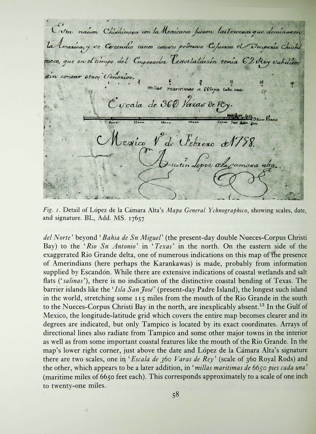
can.

     'Cfytejuc^x^.

                     /   '   / /   /**          /   'if   f   •/ '   *   *

Fig. I. Detail of Lopez de Ia Camara Alta's Mapa General Ychnographico, showing scales, date,
and signature. BL, Add. MS. 17657

delNorte"" beyond ''Bahia de Sn MigueF (the present-day double Nueces-Corpus Christi
Bay) to the 'Rio Sn Antonio^ in 'Texas'" in the north. On the eastern side of the
exaggerated Rio Grande delta, one of numerous indications on this map of the presence
of Amerindians (here perhaps the Karankawas) is made, probably from information
supplied by Escandon. While there are extensive indications of coastal wetlands and salt
flats {^Salinas''), there is no indication of the distinctive coastal bending of Texas. The
barrier islands like the ' Isla San Jose" (present-day Padre Island), the longest such island
in the world, stretching some 115 miles from the mouth of the Rio Grande in the south
to the Nueces-Corpus Christi Bay in the north, are inexplicably absent. ^^ In the Gulf of
Mexico, the longitude-latitude grid which covers the entire map becomes clearer and its
degrees are indicated, but only Tampico is located by its exact coordinates. Arrays of
directional lines also radiate from Tampico and some other major towns in the interior
as well as from some important coastal features like the mouth of the Rio Grande. In the
map's lower right corner, just above the date and Lopez de la Camara Alta's signature
there are two scales, one in 'Escala de j6o Varas de Rey' (scale of 360 Royal Rods) and
the other, which appears to be a later addition, in ''millas maritimas de 66^0 pies cada una'
(maritime miles of 6650 feet each). This corresponds approximately to a scale of one inch
to twenty-one miles.
                                               58
Inland, the territory from the coast t o ' Guasteca' and the Sierras ' Madre' and ' Gorda'
in the south northward to 'Laredo' and the 'Provincia de Coaguila' is shown. The towns,
villages, missions, fortifications, and roads of Nuevo Santander are indicated as are the
locations of its various Amerindian populations. In addition to the mountains, hills
{'lomas'\ mesas, passes, plains (e.g. 'Llano de Ramirez'), deserts (e.g. 'Desierto de 40.
leguas'\ wooded areas, and rivers also are scrupulously drawn. The provinces (e.g.
'Jurisdicion de Sn Luis Potost") surrounding Nuevo Santander are labelled, but none of
their features are detailed. The roads are in red, the vegetation in green, and the linework
and lettering in black, and the map is shaded grey, perhaps to a large degree the effect
of ageing.
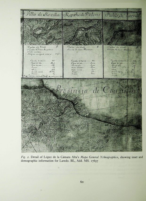
Below the title banner across the top of the map is inset a row of small town plans of
the Spanish settlements in Nuevo Santander, depicting not only each town's layout, but
also the surrounding topography. Below each plan is located an often very revealing
demographic-economic summary of that settlement in 1757. For example, for the
ranching community of Laredo the following entries appear (see fig. 2):
^Pueblo de Laredo'
Captain with no salary 0
Families 12 comprising 84 persons
Working horses 162
Breeding mares 701
Breeding cows 94
Oxen 4
Mules 125
Sheep goats 9080
Male asses 15
Female asses 20
Somewhat in contrast, for the city of Horcasitas (reached by 24 May) is indicated
' Ciudad de Horcasitas'
Captain with a yearly salary 500 Pesetas.
Sergeant with the yearly salary 250 Pesetas.
Soldiers 9 and each one yearly 225 Pesetas.
Families 73 comprising 367 persons
Indians Bapt. 12 children attached to Mission & others 95
Clergy with yearly salary 35^ Pesetas.
Working horses 276
Breeding mares 449
Breeding cattle 3^4
Oxen 68
Mules 61
Sheep goats 612
Asses 3
59
Villa dcJu w dx.'!r>Dfo ns.
PLATE V

 -a

  3
 a

 -s;

  rt
  B
 -ri
 U
  rt
PLATE VI

    "S
    '6

     •bj
This general format is repeated for all the other settlements. Taken in total, these simple
statistics help to provide a rare and realistic picture of the province and the daily life of
its colonial inhabitants at the time of the inspection.
With regard to the Amerindians, down the right side of the Mapa general below the
title banner and concluding just above the previously mentioned scales, date, and
signature is a lengthy discussion of the ' Vida costumbres i Derivacion de los Indios
Chichimecos (Life customs and Ancestry of the Chichimec Indians)'. Among other
things, it is revealed that they are 'dispersed throughout the country', use the fat of
various animals to protect their near-naked bodies from the desert sun, and dismember
the bodies of respected loved ones among family and friends as relics, preceding an all-
night wake. According to the author, the defeat of the 'powerful Mexican and Chichimec
Empire' by the 'great Hero Don Fernando Cortes' turned a once gentle people and their
descendants into strong, 'knavish' resisters to ongoing Spanish civilizing efforts. And
still typical for the times, the origins of the Chichimecs (and other Amerindians) are
related to the beginning of the Old Testament and 'the confusion... that occurred 250
years after the Deluge, in conjunction with the Pride of Building the Tower of Babel'.
This part of the map provides an informative account of the Chichimecs, synthesizing
Spanish observations on their lifestyle and recent history with contemporary Spanish
myth-history on Amerindian creation which in turn refiects the long and historic debate
on the nature and humanity of these peoples initiated by their first contact with
Columbus over three centuries previously.
While it is clearly related to the Mapa general, revealing differences in the content and
design of the smaller Mapa suggest that it was produced at a later date and for a different
purpose. The beautifully coloured smaller Mapa presents an 'artistic' overview of
Nuevo Santander in contrast to the detailed, scientific compilation in the larger Mapa
general. The Mapa has no indication of latitude and longitude but is oriented with North
at the top. However, the Mapa depicts approximately the same area as the Mapa general
with a similar extent of the coastline along the 'Seno Megicano' showing the coastal
towns, courses and mouths of rivers, great bays, and salt flats in a like manner. And again
there are no indications of the distinctive Texas coastal bend or barrier islands. There
is no grid, and no consistent scale or scales seem to be operative on this map. A
compression and skewing of the geography of this region peculiar to the works of many
non-scientific Spanish mapmakers like Haro at this time is present, with for example the
Nueces River rightly emptying into the Nueces-Corpus Christi Bay, but just above the
mouth of the Rio Grande so that the more than one hundred miles of coastline between
the two rivers is barely visible as a wetland.
Inland on the Mapa the topographical features are illustrated, and the sites of Spanish
habitation are represented by names and differentiated by small building symbols for
cities, towns, villages, settlements, and missions. On the entire map, only one non-
mission Amerindian habitation site {'Poblado de Indios') on the upper reaches of the 'Rio
de las Nueces' is shown. Some of the Spanish sites occurring also signify a later updating
of the information on the larger Mapa general as evidenced by the smaller Mapa
61Fig. J. Detail of Haro's map, showing the new settlements of Cruillas, San Carlos, and Villa
Croix. By courtesy of the Cartographic History Library, The University of Te.xas at Arlington
recording the villages of Cruillas and San Carlos, founded in 1760, and Villa Croix,
founded in 1770, almost at the centre of the map in the mountains just below the hend
in the ^ Rio de las Conchas^ (fig. 3). The establishing of all three was recommended in the
1758 inspection report to develop further and secure this part of the northern frontier
of New Spain. Thus, while it is undated, the smaller Haro map could have heen
produced no earlier than late 1770.
Across the face of the smaller map, the province, 'NUEVO SANTANDER\ is
named in large letters, but between the second 'A' and W in 'SANTANDER\
' Tamaidipas^ also appears. Across the top of the map the title banner also describes the
mapped information and names Haro as its surveyor and author. Here the first ' £ ' in
''Este'' is sumptuously illuminated in red, blue, and golden yellow. A border in the same
style frames the map. Unusually for the late eighteenth century the map has been drawn
on vellum rather than paper. Attached to the upper right corner of the map by a red
62ribbon is a portrait of Haro in the form of a paper medallion (perhaps added later). This
black and white intaglio print shows Haro with appropriate symbolism holding a caravel
of discovery. The body of the map is also coloured, with the rivers in a light, vibrant blue,
the land sand-coloured, and the linework and lettering in black.
Clearly, given its artisti-y, additions, and date ofc. 1770, the smaller map was not part
of the report of 1758. Unlike the larger Mapa general, it is a work of art more than a
scientific or official document. The Mapa is more an updated recollection of its author
than an immediate record. Although very little is known about Haro, the map's elegance
and style suggest that he may have intended it as some sort of (commemorative)
presentation piece.
The Regulations of 1772 called for the appointment of a comandante inspector, a
commander for the entire military frontier from Alta and Baja California to Texas. The
first to hold that post was the Dublin-born Lieutenant Colonel Hugo O'Conor who
served from 1772 until 1777. Perhaps Haro's Mapa was intended for O'Conor or one of
his successors or associates like the French-born Teodoro de Croix, Caballero of the
Teutonic Order, who led his own tour of inspection of the area between Durango and
San Antonio de Bexar late in 1777.^^ Whatever the case, the Mapa in Arlington, Texas
wonderfully complements the Mapa general in London and continues the story of Nuevo
Santander so thoroughly told by it.
As well as conveying a picture of a Spanish colonial province in Mexico, both maps
betray the European background and attitudes of their makers. The authors of the
inspection report, men like Rivera y Villalon, Rubi and Tienda del Cuervo, were still in
the eighteenth century hampered by Old World conceptions and vocabulary in
discussing New World colonial problems and in formulating possible solutions to them.
So, too, were the cartographers of the inspection map like Lopez de la Camara Alta,
Marcial and Haro still using Old World imagery and graphic vocabulary to portray New
World geography. Hence, the rolling hills on Haro's smaller map would be more
appropriate to areas of his Iberian homeland than to the coastal plains of Nuevo
Santander in New Spain. Beyond the technology of map compilation, these psychological
limitations may also help to explain some of the spatial compression and distortion in
their cartographic depictions of the vast landscape of these essentially alien domains.
Moreover, it should be remembered that in this latter regard the colonial administrators
and policy makers who comprised the principal intended audiences for these reports and
their accompanying maps shared in their authors' conceptual limitations, perhaps even
more so for being distant from the situations and scenes encountered by the reporters
and mapmakers. ^^
Scattered throughout collections in the Greater Southwest, Mexico, the United States
and Europe, the numerous maps of inspection of the northern frontier of New Spain in
the eighteenth century form an invaluable body of historical resources. ^^ They often very
beautifully crystallize the political, economic, social, and military situations of the
provinces and what Spain really knew (and still refused to reveal) about them and their
geographical settings in the late eighteenth century and prior to the Mexican Revolution
63for independence from Spain of 1810-21. As Meinig again so ably points out, the 'Spanish never had the manpower, skills, or resources' to master the northern frontier of New Spain.^'^ Later he continues, 'By the early i8oo's the vigor of the expansion was long past and only a thin population of mestizos and Christian Indians along the narrow strip exhibited the Spanish presence...'.'^ Because of their dispersal these maps and their related reports currently are difficult for scholars to draw upon. As Robert Becker sought out and listed the disenos of California ranchos three decades ago,^^ these maps of inspection must be located, catalogued and reproduced to provide more ready access by students of this fascinating time and place. Brought together, as has been done here in only a small way, these inspection maps will then help historians to continue to delineate and re-evaluate this very exciting and formative era in the history of the Greater Southwest and the Spanish Empire in the Americas. 1 At the outset, I particularly want to thank Jose 5 Bernard L. Fontana, Entrada: the Legacy of A. Delgado, my doctoral student and my friend Spain and Mexico in the United States (Tucson, and the Sandra Myres Graduate Research 1994), PP- 101-36. Assistant of the Center for Greater Southwestern 6 Weber, pp. 204-25. Studies and the History of Cartography at The 7 Ibid., p. 195. University of Texas at Arlington, for greatly 8 Donald E. Chipman, Spanish Texas., i$ig-i82i assisting and facilitating my Spanish language (Austin, 1992), p. 169. translations for this article. I am also indebted to 9 Weber, p. 194. Also see Herbert Eugene Bolton, Maritza Arrigunaga, Katherine R. Goodwin, ' Tienda De Cuervo's Ynspeccion of Laredo, and Shirley R. Rodnitzky from the Division of 1757', Quarterly of the Texas State Historical Special Collections of The University of Texas Association^ vi (Jan. 1903), pp. 187-203, and at Arlington Libraries and to Dr Karen S. Cook, Lawrence F. Hill, Jose' de Escandon and the a curator in the Map Library of the British Founding ofNuevo Santander: a Study in Spanish Library, for helping me to secure and understand Colonization (Columbus, 1926). many of the sources and other materials for this 10 The documents of this expedition also exist study. This article contains information which published in the Archive General y Publico de was presented previously in a paper, 'Maps from Me'xico. Historia., vols. liii-lvi. Inspections of the Northern Frontier of New 11 Mapa General Ychnographico de la nueba Colonia Spain in the Second Half of the Eighteenth Santander observados sus principals puntos y Century', at the XV International Congress on Delineados por Orden e Ynstruccion que mando dar the History of Cartography at the Newberry el Ex"'" S"'^ Marques de las Amarillas, Virrey Library in Chicago, 21-25 J""^ I993- Governador y Capitan General de esta nueba 2 See Jose Ignacio Echeagaray (ed.), Cartografia Espana d Dn Agustin Lopez de la Catnara alta Tjovohispana: una seleccwn de los manuscritos y Tente Colonel de Infanteria e Ingeniero, En grabados que.. al respecto, se conservan en el Museo Segundo de los Exercitos Plazas y Fronteras de S. Naval de Madrid (Mexico City, 1980), pp. M. y en esta nueba Espana donde demuestra parte 11-26. de las Sierras rttadre y gorda las Provincias y 3 Charles Gibson, Spain in America (New York, Jurisdiciones que la Circundan los pueblos nueba- 1966), pp. 200-1, and David J. Weber, The mente establectdos van zeparados con su exacta Spanish Frontier in North America (New Haven, figura explicando de que se compone el Vecindario^ 1992), pp. 152, 177-86, and 220. en la que se encontraron en su Reconocimiento e 4 D. W. Meinig, Imperial Texas: an Interpretive Irispeccion. [General Descriptive Map of the new Essay in Cultural Geography (Austin, 1969), pp. Colony Santander showing its principal places 23-4- and Delineated bv the Order and Instructions
that were given by His Excellency the Marques        15 See Alfred Barnaby Thomas, Teodor de Croix
   de las Amarillas, Viceroy and Captain General of         and the Northern Frontier of New Spain,
   this New Spain, to Don Agustin Lopez de la               1776-1783 (Norman, 1948 [i94i])i and Weber,
   Camara Alta, Lieutenant Colonel of Infantry              pp. 220-7.
   and Engineers, on Secondment to the Armies,          16 See Dennis Reinhartz, 'New Visions for Old:
   Fortified Places and Frontiers of His Majesty in        Encountering New World Imagery before 1800',
   this New Spain, wherein it shows parts of the            presented at the Amon Carter Museum, Fort
   Sierras Madre and Gorda, the Provinces and              Worth,    15 Feb. 1992, and Eviatar Zerubavel,
   Jurisdictions that Surround them, the newly              Terra Cognita: the Mental Discovery of America
   established towns are shown separately with             (New Brunswick, N. J., 1992).
   exact figures explaining the composition of          17 For example, see Jose de la Barcanda, Derrotero
   the Neighbourhood, and in the accompanying              hecho para mas conocimiento de las rutas desde
   Descriptions and Relations all is included with-        Durango hasta San Antonio y desde Chihuahua
   out omitting advantages or faults that were found       por el Paso de Sto. Domingo, inchiyendo villas,
   upon Survey and Inspection.], 125 x 230 cm.             pueblas, presidios, misiones y haciendas... [A
   (Mexico City, 1758), British Library, Add. MS.          Route Map made for greater knowledge of the
    17657. It was purchased in 1848 from Francisco         roads from Durango to San Antonio and to
   Michelena y Rojas, who had bought maps and              Chihuahua through the Pass of Santo Domingo,
   papers from the widow of Felipe Bauza y Cafias,         including villages, towns, garrisons, missions
    former head of the Spanish Hydrographic Office,        and ranches...], 26.5 x 35cm., sepia ink and
   in 1844. For information on the Bauza collection,       watercolour on vellum (Durango: c. 1778) in
   see Peter Barber, '"Riches for the Geography of          Catalogue Four (Austin: Dorothy Sloan Books,
   America and Spain"; Felipe Bauza and his                n.d.), no. 213 (illustrated), now in the collection
   Topographical Collections, 1789-1848', British          of Henry G. Taliaferro of New York City.
   Libraryi Journal^ xii (1986}, pp. 28—57.                Stylistically, this map is quite similar to the
12 Francisco Jose de Haro, Este Mapa comprende             smaller Haro map. Barcanda was the military
    todas las btllasy lugares de espanoles had como las    Captain of Durango, and according to Jack
   Missiones de indios y presidios existentes en la        Jackson   of Austin, this map may have been
   Provincia de Nuevo Santander para niejor saber de       drawn by Luis de Bertucat in part to show the
    los mismos. Como lo observo y lo dibuxo por orden      route of Teodoro de Croix's inspection. See also
   superior Fray Josep de Aro de la orden de San           Juan Agustin Morfi, Derrotero. Hecho por Coman-
   Francisco. [This map comprises all the villages         dante General Cavallero de Croix [Route Map.
    and places of the Spaniards as well as the             Made for Commanding General Sir Teodoro de
    Missions for the Indians and the presidios             Croix], 54 X 56 cm. (Mexico City, 1778), Carto-
    existing in the province of Nuevo Santander            graphic History Library, The University of
    from the best knowledge about the same. It was         Texas at Arlington, 85-26, 92/1, X5.
    surveyed and drawn under the superior orders of 18 D. W. Meinig, Southwest: Three Peoples in
    Fray Jose de Haro of the order of Saint Francis.]      Geographical Change (New York, 1971), p. 12.
    (Mexico City, c. 1770), Cartographic History 19 Ibid., p. 15.
    Library, The University of Texas at Arlington, 20 See Robert H. Becker, Disenos of California
    86-255, 50/1, X / 2 . It was purchased from an         Ranchos: Maps of Thirty-Seven Land Grants,
    Austin, Texas, book and documents dealer.              1822-1846 from the Records of the United States
13 King Carlos III made a royal grant of the whole         District Court, San Frarictsco (San Francisco,
    of Padre Island in 1765 to Padre Jose Balli after      1964), and Robert H. Becker, Designs on the
    whom it is today named.                                Land: Disenos of California Ranchos and Their
14 Also on the Mapa, see the third and last volume         Makers (San Francisco, 1969). Similar land-
    of Robert Weddle's history of the Gulf of              grant documents also exist in Texas (especially
    Mexico, Changing Tides: Twilight and Dawn in           those of the Texas General Land Office) and
    the Spanish Sea^ iy6j-j8oj        (College Station,    other Southwestern state archives.
    i995)> PP- 36-41-
You can also read