Release Guide - GEOSYSTEMS
←
→
Page content transcription
If your browser does not render page correctly, please read the page content below
Release Guide

Release Guide
M.App Enterprise 2021

Version 16.7

1 March 2021
Contents
About This Release .................................................................................................................... 4
   Important Note ........................................................................................................................ 4

M.App Enterprise Product ......................................................................................................... 4

M.App Enterprise Enhancements and New Features .............................................................. 5
   Azure Active Directory .............................................................................................................. 5
   Branding/Theming .................................................................................................................... 6
   Browser Apps Creation ............................................................................................................. 7
   Feature Analyzer .................................................................................................................... 10
      New Map View Wizard ........................................................................................................ 10
      Attribute Preview Enhancement .......................................................................................... 10
      Functional Attribute Enhancement ...................................................................................... 11
      M.App Enterprise Map View Support (LuciadRIA Map Views) ............................................ 12
      Motif Colour Synchronization Enhancement ........................................................................ 13
      Multi-Dataset Support .......................................................................................................... 14
      New Chart: Tabbed Chart Container ................................................................................... 18
      New Chart: Workflow Widget ............................................................................................... 19
      New Global Window Style – Modern ................................................................................... 21
      Spatial Filter Enhancements................................................................................................ 23
      Tooltip Definition Enhancement ........................................................................................... 23
   Legend Behavior .................................................................................................................... 24
   New M.App Editor for Browser Apps....................................................................................... 24
   OGC Plugin ............................................................................................................................ 26
   SAP Hana ............................................................................................................................... 28
   Style Editor ............................................................................................................................. 29
   Spatial Workshop.................................................................................................................... 32
   Two-factor Authentication ....................................................................................................... 33
   Various Enhancements ........................................................................................................... 34
      App Type Filter in My Apps Page ........................................................................................ 34
      AutoComplete Fields in Lists ............................................................................................... 34

1 March 2021                                                                                                                                  2
EPSG Code or Name .......................................................................................................... 34
      Go to Apps Page Button ...................................................................................................... 35
      New Icons in Desktop Client................................................................................................ 35
      Changing Unit of Measurement (UOM) in the Desktop Client ............................................. 36
      Support for Panoramics ....................................................................................................... 36

Issues Resolved ....................................................................................................................... 38

About Hexagon......................................................................................................................... 43

1 March 2021                                                                                                                            3
About This Release
This document describes the enhancements for M.App Enterprise. The information in this document is current
as of the product release. For the most current version, visit the Hexagon Geospatial Support Portal.

This release includes fixes and enhancements to M.App Enterprise. For information on product fixes, please
review the Issues Resolved section. For information on enhancements, read the New Technology section.

This document is only an overview and does not provide all details about M.App Enterprise’s capabilities. For
additional information about M.App Enterprise, please read our online help and other product documentation.

Important Note
This release of M.App Enterprise is a kind of “hybrid.” Despite the introduction of new features (Style Editor,
M.App Editor, Feature Analyzer), pre-M.App Enterprise 2021 configurations and components are still there and
working.

Some components and frameworks will be deprecated and gone with M.App Enterprise 2022:
   • Old Style Editor
   • Old M.App Editor
   • Browser Apps based on Leaflet
   • Feature Analyzer based on Leaflet
   • BI Map Wizard

M.App Enterprise Product
M.App Enterprise is an on-premises platform for creating geospatial apps for your organization. M.App
Enterprise stores your imagery, vector and point clouds, workflows, analytics, and queries, which are all
accessible in one place from an easy-to-use interface. With the M.App Enterprise platform, you can build and
deploy your own geospatial applications (called Hexagon Smart M.Apps) to solve your organization's business
problems. Hexagon Smart M.Apps are cloud-based, targeted, lightweight, and dynamic apps that provide
answers and present information in a visual and compelling way.

M.App Enterprise delivers a privately hosted solution for organizations that want to realize the value of a Smart
M.App deployment but stay within the confines of their enterprise network.

With M.App Enterprise, you can access Smart M.Apps anywhere within your organization's network for real-
time answers.

1 March 2021                                                                                                    4
M.App Enterprise Enhancements and New
Features
Azure Active Directory
Azure Active Directory (Azure AD) is Microsoft’s enterprise cloud-based identity and access management
(IAM) solution. Azure AD is the backbone of the Office 365 system, and it can sync with on-premise Active
Directory and provide authentication to other cloud-based systems via OAuth.

When creating a new tenant, you now have the possibility to use Azure AD for that specific tenant.

For a tutorial and video, visit: https://community.hexagongeospatial.com/t5/M-App-Enterprise-Tutorials/How-to-
use-Azure-Active-Directory/ta-p/41537

1 March 2021                                                                                                5
Branding/Theming
With the release of M.App Enterprise 2021, it is possible to change the theming within the platform and also
change the header and icon colors to your liking.

You can change the theme in the user settings (Management, Studio, Apps).
There are 3 possible options:
     •   Automatic - uses the same setting as your OS
     •   Dark - forces the dark theme
     •   Light - forces the light theme

 In the desktop client there is a dedicated button      , which allows you to overwrite the OS settings.

1 March 2021                                                                                                   6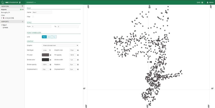
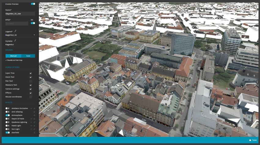
For more information, visit: https://community.hexagongeospatial.com/t5/M-App-Enterprise-Tutorials/How-to-
use-custom-branding-change-the-theme-for-MAE/ta-p/41539

Browser Apps Creation
M.App Enterprise 2021 changes the browser app configuration. Beside of the live preview of your configuration
(available only if Enable Preview is activated) the legend and EPSG are defined. In addition, standard
configuration (Styleset, Bounds) and additional Viewer Options and Effects (which come in from LuciadRIA)
are displayed.

Note: Tilting is not possible when 3D is activated and manual bounds are chosen.

If you click on the icon beside of any of the available datasets within the legend, the map automatically zooms
in to the bounds of the dataset.

1 March 2021                                                                                                  7
With the new release it is possible to add effects to your browser application. This can be done by an
administrator, or it be made available to the end customer by clicking on the lock icon on the right side of the
effects panel.

Here is a comparison of a browser app without and with effects:

1 March 2021                                                                                                       8
For more information, visit: https://community.hexagongeospatial.com/t5/M-App-Enterprise-Tutorials/How-to-
setup-a-browser-app-with-MAE-16-7/ta-p/41540

1 March 2021                                                                                                 9
Feature Analyzer

New Map View Wizard

The New Map View Wizard is the landing widget when first starting a new Analyzer view. A major change has
been introduced in this release: a map view must be defined first in M.App Enterprise Studio before using a
LuciadRIA widget or the New Map View Wizard. Once a map view is selected, the legend and style will be
loaded. Analyzer will give you the option in the Analyzer Layer Selection section to pick datasets you want to
use as Analyzer datasets. When clicking OK, Analyzer will:

    •   Create a new Map View with the associated legend and styleset
    •   Automatically create dataset references to layers selected in the Analyzer Layer selection section
    •   Add anything not selected or not selectable as a background layer
    •   Automatically generate a theme widget if a classification is defined as part of a styleset
            o Any theme widget automatically generated will remain in sync with the styleset
                classification/categorization

You can run this wizard more than once if you want to use multiple Map Views in your Analyzer View. To

launch the New Map View Wizard, click the new Map View Wizard button,            , in the Dataset Configuration
tab.

Attribute Preview Enhancement
Attribute preview has moved. To activate attribute preview, click the i icon on the dataset header.

1 March 2021                                                                                                  10
Functional Attribute Enhancement Functional Attributes have been moved in this release. You can now create/edit functional attributes from the Dataset Configuration screen. To create a new functional attribute, click the + icon on the dataset header. To delete a functional attribute, click the x beside the functional attribute you want to delete. To modify an existing functional attribute, click the pen icon to the right of the functional attribute name. Note that the new Attribute Preview Widget allows you to see results of your functional attribute immediately if the preview window is open for the dataset that contains the functional attribute. 1 March 2021 11
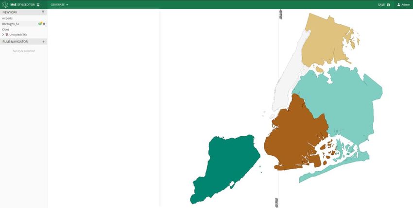
M.App Enterprise Map View Support (LuciadRIA Map Views)
M.App Enterprise Map Views are now completely supported in Feature Analyzer. M.App Enterprise Map Views
allow you to define complex styles, legends, map view projections, tools, and options.

Setting a Map View configuration is mandatory in this release of Feature Analyzer. A Map View configuration
can be set in the General Tab of a LuciadRIA widget.

Once a Map View configuration is set, an additional Style Set color option will be available for each feature
docked in the LuciadRIA Map View widget.

Note that when Color by: Style Set is selected, line, point styles from within Analyzer are now unavailable as
this is completely driven by the M.App Enterprise Style Set.

Style Properties
Feature Analyzer adds two dynamic properties to a feature dataset to allow for dynamic styling. These two
properties are fa_disabled, and fa_measureValue. They can be used from within the M.App Enterprise Style
Editor.

fa_disabled (optional): indicates that a feature in the dataset is not part of a selection. This is used when
defining a filter for a styleset. For example, in the image below, Queens is selected (fa_disabled = false).
Staten Island, Brooklyn, Manhattan, and Bronx are not selected (fa_disabled = true). If a filter using
fa_disabled is not used, a default disabled style will be automatically applied by Analyzer.

Sample filters for selected items:

1 March 2021                                                                                                     12
Motif Colour Synchronization Enhancement
A new option has been added to the Motifs tab to keep your M.App Enterprise branding in sync with your
Analyzer views. If you want to use M.App Enterprise branding, enable the “Use M.App Enterprise
Branding/Theme” option. This option will also use dark/light theme modes as defined by the user or from
default browser settings.

1 March 2021                                                                                              13
Multi-Dataset Support
You can now easily add and manage multiple datasets in Feature Analyzer. By default, when you first create
an Analyzer view, a default dataset with no data will be created. This dataset is a container for the default map
view (referenced in the Additional Charts tab). There are several new functions in the Dataset Configuration
dialog. These are Add Dataset, Delete Dataset, Update Dataset, Link Datasets, specify linking options, Import
View, and Export View.

Add Dataset

    •   You can add a dataset to your view by clicking the “Add Dataset” button. This button,         , is located at the
        lower left of the Dataset Configuration dialog. The Dataset Configuration dialog will open:

        This screen replaces the original Dataset Configuration definition screen. There are new options in addition to the
        previous dataset definition screen. These new items are Local File, No Data, Update Interval (seconds),
        WebSocket Url, and Create Feature Layer

    •   Dataset Name
        This option allows you to specify a unique name for your dataset. This dataset name will be referenced in the
        Dataset Configuration, Functional Attribute, Additional Charts, Additional Features, and Tooltip configuration tab.

1 March 2021                                                                                                                14
• Local File
The Local File option is now available on the M.App Enterprise platform. This lets you import small datasets (<
15MB) directly from a file on your hard disk. These datasets are stored directly in the view configuration file.
Larger datasets need to be imported into the M.App Enterprise content database.
• No Data
The No Data option allows you to specify a dataset with no data. With these types of datasets, you can host
widgets that require no Analyzer data like Leaflet Map Views, Luciad RIA Map Views, and HTML Display widgets.
• Update Interval (seconds)
This option has been moved from the Advanced tab in the Field Configuration dialog. You can now specify an
independent update interval per dataset.
• Websocket Url
The WebSocket Url specifies a service to provide real-time additions to a dataset. The WebSocket payload to add
new records to an existing dataset is as follows:
{
type: “new”,
data: [ {} ]
}
The schema of the new record must match the dataset the new record is being added to.
• Create Feature Layer
You can now specify attribute-only datasets. If you use an attribute dataset (i.e. no geometry feature information),
uncheck this option. If you have geometry features in your dataset and a map view visible, the geometry will be
automatically added to the map view when this option is checked.
• Cancel
Closes the Add Feature Data dialog without adding the dataset to the view.
• Connect
Analyzer will attempt to connect to the dataset. If an error occurs while making this connection, an error dialog will
appear with the error details. Once the connection has been made, the Add Feature Data dialog will close, and
you will see your new dataset in the Dataset Configuration screen.
Dataset Linking
You can now easily manage dataset links. Dataset links can be made by dragging a field in one dataset to a field in another
dataset. Once a link has been made, a red line is drawn between the two field names. When two datasets are linked,
filtering one dataset in the relationship will affect filters on the linked dataset. Take the following dataset configuration as an
example:
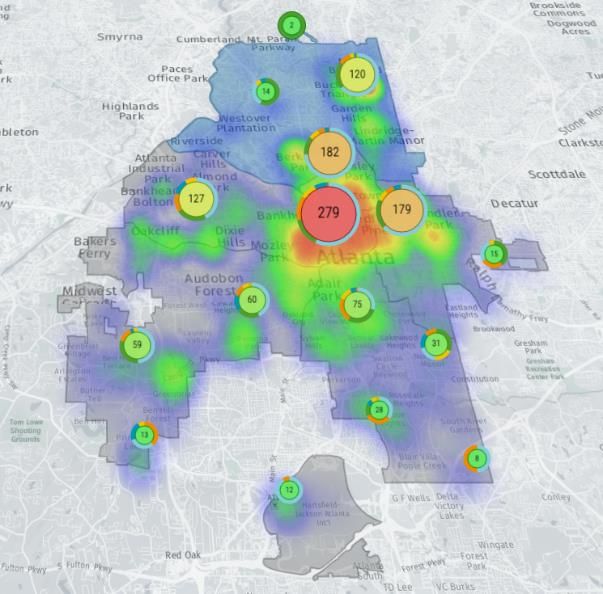
There are three datasets. The Default dataset contains a single widget – a LuciadRIA map view. Atlanta2 contains points,
and atlboundaries contains polygon features. With this setup, these datasets will filter independently of each other. When a
boundary is clicked (uppermost), the Heatmap and clustered point features remain unfiltered:
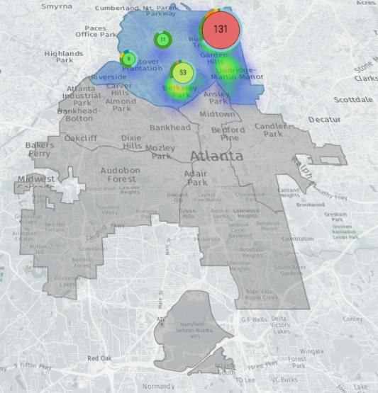
1 March 2021 15Here is the result when a link is established between “BeatId” on the atlanta2 dataset and “ZONE” on atlboundaries. Now when a geometry is selected on the atlboundaries dataset, the atlanta2 dataset will filter to reflect the geometry selection. Note than when using M.App Enterprise datasets, you may need to click “Apply” for all the necessary attribute data to download. 1 March 2021 16
Link Configuration

The configuration cog,          , lets you specify an inner vs. outer join on the linked datasets. By default, datasets
are linked via inner join. If a record does not match, it will be filtered out. (If no points fall within a boundary
feature, the system will not display the boundary feature.) In some instances, it is desirable to include unlinked
records and features. Uncheck this option if you would like to see all data when no filters are defined in
instances where field data from the first dataset does not match any data in the second dataset.

Enable N-Level Deep Linking
By default, Analyzer preforms a 1-level deep link on datasets. This is done to facilitate simple scenarios and
avoid circular linking references. Take, for example, this scenario of Dataset A  Dataset B  Dataset C. If
you filter Dataset A, Dataset B will update to reflect the filter of Dataset A. However, Dataset C will remain
unfiltered. If you have a scenario where you need a filter to carry through to all linked datasets, click the Enable

N-Level Deep Linking button,      . Be careful with circular references (e.g., Dataset A  Dataset B
Dataset C  Dataset A). Analyzer will attempt to resolve these, but you may get undesired filtering results.

Deleting a Link
To delete a dataset link, click the X in the middle of the line.

View Template Import/Export
You can now import/export views as view templates from the Dataset Configuration screen.

To import a dataset, click the import button,        . This will open up the view template screen:

Once a view template is specified, click Import to load the view.

To export or save your view templates to your downloads folder, click            . This option is still available on
the Menu->Export menu item.

Error Handling
If a dataset fails to load, Analyzer will continue to load all remaining datasets. You can see which dataset failed
to load on the loading dialog and the dataset configuration dialog. The dataset in an error state will be colored
red. You have the option of deleting the dataset or editing the dataset to correct the error.

Once the error is resolved by editing, the dataset definition will update to show that the error is cleared and
also show available attributes.

1 March 2021                                                                                                           17
New Chart: Tabbed Chart Container

You can now dock your charts into a tabbed container. This allows for a much cleaner dashboard interface in
cases where many widgets are required. The tabbed container will show you which docked charts have filters
enabled and also quickly clear the filters by clicking the filter icon, . To enable this functionality, create a
Tabbed Chart. Set the dock type of your existing charts to the name of your new tabbed chart.

1 March 2021                                                                                                       18
New Chart: Workflow Widget
You can now easily use M.App Enterprise Workflows from within Feature Analyzer. To use a M.App Enterprise
Workflow, add a new Chart and set the type to Workflow.

You will need to specify the workflow name and the start-up form. If you don’t want your workflow widget to
automatically start when the view loads, uncheck Start on Load. This is useful in cases where you want your
workflow to start from another action (e.g., clicking an Edit button from within a tooltip).

You may wish to set some additional style parameters to control the execution of your workflow. Two common
options are Allow User Mode Resizing and Hide from Charts Menu. Allow user mode resizing allows the
user to move/size the workflow window freely, while the Hide from Charts menu gives added control over how
your workflow is launched.

Launching a Workflow
There are a few common ways to launch a workflow. The first is via an action on a tooltip. To do this:
   1. Create a workflow widget. Take note of the workflow widget name.
   2. Create a functional attribute. Insert the Launch a Workflow example.
   3. Update the functional attribute dataset, if applicable.
   4. Update the chartTitle parameter to match your workflow widget name.
   5. Note that the default command button text is “Edit”. You can change this.
   6. Click Apply.
   7. On the Tooltip Configuration tab, add the new functional attribute.
   8. Click Apply.

The next method is via an HTML chart. To do this:
   1. Create a new HTML chart.
   2. Insert the Launch a Workflow example.
   3. Update the workflow title to match your workflow widget title (the default is “Editor”).
   4. Click Apply.

Workflows can also be lauched via API:
       Analyzer.workflows.getWorkflowByTitle("Editor").launchWorkflow(optional record id);

If you launch a workflow in Studio mode, the workflow will launch with a login prompt. This is done because an
Apps session ID is needed to launch the workflow. A login prompt will not appear in Apps mode.

Workflow API
You can access Analyzer API from within a Workflow script. Simplified workflow API has been made available
to preform common functions. Most of these functions are in the Analyzer.workflows namespace.

1 March 2021                                                                                               19
Analyzer.workflows.getAllWorkflows(): Returns an array of all workflow widgets defined in Analyzer
Analyzer.workflows.getWorkflowByTitle(title): Returns a specific workflow widget by widget title
Analyzer.workflows.closeAllMapPopups(): Closes all active popup windows in all map views
Analyzer.workflows.updateWorkflowDataset(workflow): Tells Analyzer to reload the dataset tied to the
workflow; will reflect any edits immediately in Analyzer
Each workflow object also has a set of functions:
Workflow.closeWorkflow(): Closes the workflow widget in Analyzer
Workflow.launchWorkflow(optional record id): Launches the workflow and makes the workflow widget
visible to the user
Example Workflow script for a simple attribute edit operation:
var Analyzer = window.parent.Analyzer;
var workflow = Analyzer.workflows.getAllWorkflows()[0];
function closeWorkflow() {
Analyzer.workflows.closeAllMapPopups();
workflow.closeWorkflow();
}
function saveForm() {
IG.submit('Form','Save').done(function(result) {
Analyzer.workflows.closeAllMapPopups();
workflow.closeWorkflow();
Analyzer.workflows.updateWorkflowDataset(workflow);
});
}
1 March 2021 20New Global Window Style – Modern A new window style has been added that changes the appearance of each widget window. By default, the modern setting is now used. This option is available in the Motifs Configuration tab. Traditional Setting Modern Setting 1 March 2021 21
New Individual Chart Window Styles

Transparent Background
New options have been added as a style setting for each chart. These can be accessed in the Style tab of the
Additional Charts tab. Each chart now has the option of configuring the chart window background as
transparent. To enable this, check “Transparent Background.” This is useful if you want to create a widget that
extends the functionality of other charts. For example:
.

A transparent HTML chart has been placed on the Date chart to extend the capability of the date chart.

Hide from Charts Menu
Active widgets in Analyzer are typically listed in the Charts menu and can be toggled by the user. Check this to
remove a widget from this menu.

Allow User Mode Resizing
Allows a user to resize and move widgets in Apps mode.

Automatic Width (HTML Widget)
The width of the HTML Widget will be automatically determined by content size.

Automatic Height (HTML Widget)
The height of the HTML Widget will be automatically determined by content size.

LuciadRIA View Enhancements
You can now use heatmaps, cluster layers, spatial filter drawing tools, fit all, and zoom tools within a
LuciadRIA view. Line and point styles can be defined in meters in addition to pixels.
Measurement Tools are now built in. To activate measure, click the Measure Icon in the 3D View:            . The
following panel will display:

By default, the Distance measure is active.

1 March 2021                                                                                                       22
Spatial Filter Enhancements
Spatial filters can now be applied per layer in each map view. Once a spatial filter is defined, spatial filter layer
toggle options can be accessed via the Layers menu by clicking the filter icon, .

Tooltip Definition Enhancement
You can now define tooltips for multiple datasets from the user interface. A new command strip has been
added to the tooltip configuration tab. To switch between datasets, click the dataset name.

The tooltip window activated from the map view has been redesigned. If a tooltip window is too large, the
tooltip window will now scroll.

1 March 2021                                                                                                       23
Legend Behavior
With the M.App Enterprise 2021 release, there is a unified place for legends. You will find them in Content ->
Legends. With this change, it is possible to use a legend regardless of client. Drag and Drop still works as
before with two changes:

    •   Themes are not required any longer.
    •   The visualization for VectorSets is different. On the left side you only see the name of the VectorSet, but as soon
        as you drop it in the legend it gets unraveled, and you can handle the single layers as you knew it from previous
        releases.

New M.App Editor for Browser Apps
The M.App Editor, introduced in M.App Enterprise 2021, got a new framework.

The way you work with the new M.App Editor is the same as in previous releases. A simple drag-and-drop
allows you to insert Map Views, Feature Analyzer Views, and Recipes in the browser app.

1 March 2021                                                                                                             24
The Custom Panel gives you the opportunity to access the API in the background. To give you a helping hand, some code snippets are also available to use within the browser app. Because in the background we are using the entire LuciadRIA API, the handling of code is reworked and you get the feeling of working with a visual interpreter of your custom code: 1 March 2021 25
OGC Plugin
In this release, we offer a new plugin in the desktop client. It is now possible to add various OGC Services
directly on the client side.
Note: If you want to use the same OGC service for different located clients, you still have to use the GeoService tab in M.App Enterprise Studio.

The icon of the plugin looks like this:                      .

1 March 2021                                                                                                                                        26
1 March 2021 27
For more information, visit: https://community.hexagongeospatial.com/t5/M-App-Enterprise-Tutorials/OGC-
Plugin/ta-p/41707

SAP Hana
With this M.App Enterprise release, we introduced the 4th fully supported database provider: SAP Hana. Fully
supported means that it doesn’t matter if your master DB, tenant DB, or data DB is in SAP Hana. The limitation
of the database itself is the only limit of SAP Hana in M.App Enterprise.

1 March 2021                                                                                               28
Style Editor
One big feature in this new release is a completely reworked Style Editor. To describe all new features would
be out of the scope of the Release Guide, but the most important and most obvious ones are highlighted here:

    •   Live preview of the styles in the map on the right side

1 March 2021                                                                                               29
• Classify and Categorize allows you to get simple styles quickly via a wizard. Just select the style for which you
want the classification done and the corresponding database field.
Note: Only numeric fields are allowed for Classify.
1 March 2021 30• Filter and rearrange layers within the style editor. You can filter all styled layers to the ones you currently need,
and if one or more layers are overlapped, a simple drag-and-drop approach solves this issue.
For more information, visit: https://community.hexagongeospatial.com/t5/M-App-Enterprise-Tutorials/How-to-
use-the-new-Style-Editor/ta-p/41541
1 March 2021 31Spatial Workshop You can now find the Spatial Workshop in Content -> Spatial Recipes after you’ve created a new spatial recipe or edited an existing one. 1 March 2021 32
Two-factor Authentication
Two-step verification or two-step authentication is a method of confirming a user's claimed identity by
using something they know (password) and a second factor other than something they have or something
they are (Wikipedia, 2 December 2020).

In M.App Enterprise, there are several options where you can enable/disable two-factor authentication.

    •    Management
    •    Studio
    •    Apps

But you can also set it as a requirement when creating a tenant.

This checkbox is inherited by every user (Studio users as well as Apps users).

Figure 1: No worries -> your QR code is working and looks like a correct QR code.

For a tutorial and video, visit: https://community.hexagongeospatial.com/t5/M-App-Enterprise-Tutorials/How-to-
set-up-Two-factor-authentication/ta-p/41538

1 March 2021                                                                                               33
Various Enhancements
App Type Filter in My Apps Page
Based on the Product Idea https://community.hexagongeospatial.com/t5/Product-Ideas/Overview-Apps-
Page/idi-p/37568, with M.App Enterprise 2021, it is now possible to filter your created apps based on the type.
And with the enhancement AutoComplete Fields in Lists, you can also filter the entire list on the fly.
AutoComplete Fields in Lists
Beside Filter, we introduced an AutoComplete Field in lists, which allows you to just type in character(s) and
the list gets automatically filtered.
EPSG Code or Name
With the M.App Enterprise 2021 release, we introduced a new behavior in using EPSG codes within the apps.
Type in the EPSG code or the name and get the result as a dropdown list.
und
1 March 2021 34Go to Apps Page Button
Instead of copying the URL of M.App Enterprise Studio, replacing some URL parameters, and searching out
the hashtag in the URL to run the MyApps Page, a new method has been introduced in this release. In the
Studio, there is a new button called “Go to Apps Page” that allows you get to the login window with one simple
button click.
New Icons in Desktop Client
In M.App Enterprise 2021 you will find three new icons in the right top corner of your desktop app.
From left to right:
• Switch themes: Currently, the desktop client uses the values of your operating system. With this icon, you can
overwrite this behavior.
Note: If you switch the theme, the app is restarted.
• Reload: The reload of the app is now an icon instead of a plain button with text.
• Help: This icon is back in M.App Enterprise and allows you to open up the documentation on FluidTopics.
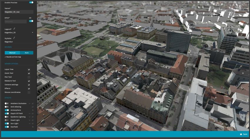
1 March 2021 35Changing Unit of Measurement (UOM) in the Desktop Client With the release of M.App Enterprise 2021 we introduced a new feature, which allows you to change the UOM on the fly. At the bottom right you find the current UOM (default = meter), and by clicking on it you can change it to the following options: This setting is saved on the client side. Only a manual override will change it. Support for Panoramics Note: Panoramics only work in M.App Enterprise 2021 with a PRO license. Note: You have to do all the data crawling and creating of the service itself in LuciadFusion for M.App Enterprise. With the 2020.1 release of the Luciad portfolio, panoramics were introduced with a new service endpoint, which is also available in M.App Enterprise 2021. 1 March 2021 36
As soon as you point to the endpoint of the panoramics service, you should have it available for all browser-
based apps. You can use it in a “normal” map view based on LuciadRIA as well as in Feature Analyzer. To exit

panoramics mode in Feature Analyzer, click the door icon,     .

For more information, visit: https://community.hexagongeospatial.com/t5/M-App-Enterprise-Tutorials/How-to-
visualize-Panoramics/ta-p/41542

1 March 2021                                                                                              37
Issues Resolved
Salesforce Ticket Number   Subject                                     Description
                                                                       We have customer data that has more
                                                                       than 300k records for the feature data to
                                                                       be used on Analyzer. The boundary data
                                                                       that is linked has more than 600k records.
                           Feature Analyzer doesn't honor scale set
00056102                                                               The analysis is done fine with feature data,
                           on Dataset
                                                                       but when doing a zoom to all the country it
                                                                       takes some time to load the boundary, and
                                                                       sometimes it reaches the memory limit of
                                                                       the browser .
                                                                       Is a customized legend
                           Customized legend: unpleasant               (custom_legend.png) visualized in other
00045490
                           visualization                               charts - for example within the Date-Chart
                                                                       - there are three '|||' set in front of the text.
                                                                       The WMS service from M.App
                           M.App Enterprise - WMS service without
00032807                                                               (MyGeoservices) does not work correctly
                           request
                                                                       when REQUEST is not present in the URL.
                                                                       When importing datasets into Vector Data
                                                                       in MAE the import goes fine. However
                                                                       when reviewing the imported Vector Data it
                           Vector data imported as EPSG 2925           is showing as invalid when Caching is
00043620
                           shows invalid when set to Caching           checked during the import. Upon further
                                                                       review there is message that "An error
                                                                       occurred importing vector data! Please
                                                                       define caching information manually.
                                                                       When reviewing usage in the master
                                                                       database the Usage records are tracked
                                                                       accurately to the date the session
                           Usage reported one day before in            occurred. However, we have noticed that
00044802
                           Management statistics                       in Management, the Usage report is
                                                                       showing these same records as though
                                                                       they occurred a day earlier than they
                                                                       actually occurred.
00060468                   German Official WFS not running
                                                                       Bar graph Widget in MApp Enterprise
                                                                       Browser Application, the numbers in the
                           Sorting Value Legend after Manual
00069647                                                               legend aren't sorting from 1 to 10, but they
                           Configuration of colours
                                                                       are doing the following:
                                                                       1,10,2,3,4,5,6,7,8,9.
                           Selection via Map on bigger scale in rich
00062533
                           client not working
                                                                       There is a problem using attribute based
                                                                       text-styling. Assigning databasefields for
00063834                   Text Style Rich Client                      "fontfamily", "fontstyle" and "fontweight"
                                                                       takes no effect on the text shown in the
                                                                       application.
                                                                       With expert point placement a value from
                                                                       database for the rotation angle is used.
                           Browser does not support expert point
00031667                                                               This works fine in desktop, but in browser
                           placement: label rotation
                                                                       same feature class with same settings are
                                                                       displayed standard, without rotation.
                                                                       In the Styleset of M.App Enterprise Studio
                                                                       I have the possibility to define different
                           M.App Enterprise: Styleset > different
00036726                                                               styles for different scales. But all additional
                           Scales: not shown in GUI
                                                                       scales disappear after saving and cannot
                                                                       be displayed.
                           WMTS not working on the same WMS
00067240
                           data
                                                                       When using the MODIFY command to edit
                                                                       Polygon/Line features that contain curves
                           Saving of MODIFY when edit feature          there will be an error upon saving those
00056513                   against Oracle line/polygon with curves     edits. ORA-29877: failed in the execution
                           brings error                                of the ODCIINDEXUPDATE routine ORA-
                                                                       13347: the coordinates defining an arc are
                                                                       not distinct

1 March 2021                                                                                                         38
00055343 SRID missing for WMS
Failing to remove a vertex results into a
00069956
bug
When trying to add a geometry to an
00061708 Geometry won't save on persisted element
existing element, it creates a new entry.
When a datatimepicker FormField which
contains override=true, getdate() as a
defaultvalue and visible=false gets
Cannot parse datetime value into a
00066756 created, it throws an error:
datetimepicker FormField
The string was not recognized as a valid
DateTime. There is an unknown word
starting at index 0
00067168 Edit geometry will not perform a fit action
Visual Bug when using the move option in
00067165
edit geometry mode
Heatmap doesn't honour value order on
00058507
axis when working with numbers
00059255 Json template import problem
There is a COVID-19 Feature Analyzer
M.App that displays case counts by zip
code in ranges of 5. Functional Attributes
00068601 Pie Chart Legend Order
to group the counts in the ranges is used
but the resulting pie chart doesn't order the
legend entries in numerical order
The save button does not appear though I
Feature Analyzer - View Template cannot click on several tabs of the configuration.
00068777
be saved Also, adding a chart does not make the
save button visible.
Feature analyzer data are showing
00059436 Feature Analyser issue perfectly (as cluster ) on 16.5.6 version but
on new version data is showing (points).
Error occured while importing vector data -
00060473
EPSG 25833
00069044 Geometry locate not working
Error while trying to load a live area
00069443
dataset as a boundary in feature analyzer.
When you run installation repair from
Control Panel it will delete
WarehouseLocation value from the master
database, ending up in not working
Installation repair cannot finish, breaks environment - M.App Service cannot be
00069774
installation started. The installation repair thus cannot
be finished and rolls back. Furthermore,
MAE configuration must be re-run for
adding the WarehouseLocation property
back to master database.
Registration of the M.App Enterprise
00070080
Usage is not correct
MAE - STUDIO - STYLESET - Deleting a
00070174 STYLESET in studio doesn't deletes its
matching folder in the server
Queries - on a field with values like
"2558/6" defined as text - with input
00070586 Desktop Queries
"2558/6" does not work but with 2558_6" it
works.
After creating a new FA view and opening
the FA editor, trying to apply a FEATURE
DATA source prompts an error: "Error
BROWSER - FEATURE ANALYZER -
reading the input feature data: Cannot
00070960 Error reading the input feature data:
read property 'find' of undefined". This only
Cannot read property 'find' of undefined
happen if the tenant doesn't have a
registered VECTOR SET in the tenant's
DB schema
1 March 2021 39Can´t use database field for rotated
00071732
symbology
00052625 Desktop app shuts down on opening
Language for M.App Enterprise won’t be
00053028
downloaded automatically
STUDIO > My GeoServices > Dataset list
00060982 in empty if not making at least one Vector
Set in tenant
Desktop queries raise error when using
00063898
Hebrew characters in query where clause
Updating Hebrew language package make
00063941
desktop app not to work
Print Layout Editor - Ungroup button
00064015
missing
DESKTOP > PRINT LAYOUT EDITOR -
00064467 How to add MAPCROSSES on top of a
map element?
DESKTOP > PRINT LAYOUT EDITOR -
00064469 After opening a *.mepl file, the MOVE
ELEMENTS tool isn't working
Feature Analyzer Tooltips on polygon,
don't work anymore in latest version of
00064525
Chrome (Version 83.0.4103.61 (Official
build) (64-bits)
DESKTOP - Count of records in query
00064515
result don't appear until removing a record
They work only in Edge browser. On other
00064568 Tooltips work only on EDGE browser browser we have always the "open hand"
(pan symbol icon)
DESKTOP > PRINT LAYOUT EDITOR -
00064635
How to set legend for right-to-left entries?
DESKTOP > PRINT LAYOUT EDITOR -
00064735 Text element containing LOWERLEFT
placeholder, having wrong X coordinate
MAE don't read attributes and views data
00064953 from other than the “public” schema of
PostgreSQL – only for Attribute DATA
DESKTOP - App is crashing when
00065187
scrolling zoom fast
DESKTOP > PRINT LAYOUT EDITOR -
00065412 Having a long layer name in legend,
makes column to disappear
Some texts are in English despite German
00065742
language settings
00065862 Running feature buffer recipe failed
DESKTOP > ACTION SET - workflows to
00066045 be accumulated instead of being replaced
when opened more than once
DESKTOP - Upgrading to 16.6.364.4 from
00066183 16.6.265.2 causes errors with app
handling geometry create\edit workflows
00034280 Custom polygon styling
The text rotation works in the preview but
00034299 text rotation issue
will not work when applied to the map.
Database entries with commas, which are
used as tooltips in a Feature Analyzer app,
Feature Analyzer - Export Attribute Data - get a csv file where all commas within the
00053700
CSV cells are replaced by an underscore and
the cell content is enclosed in quotation
marks.
1. No option to rotate point feature when
creating. 2. The desktop app gets 'stuck'
when trying to edit an existing entity (point
DESKTOP CLIENT - Geometry in this matter). Some background notes: 1.
00054754
creation\modify problems Inspecting our ORACLE DB generated
entities in a SQL client (PL/SQL
Developer) resulted with some notions: 1a.
The before-installation entities have a 6
1 March 2021 40row 'sdo_ordinates' while the new one
haven't got any. 1b. There's some
inconsistencies in the 'sdo_elem_info' as
well. 2. This is the JavaScript we used for
modify geometry action
SC.digitize('AMUDIM', {commands:
['MODIFY','MOVE'], startOnLoad:
'MODIFY'},{FORM.ID})
If they're shared, ME adds [shared] to the
00066951 Import of [Shared] Bookmarks export, which causes an error when
importing it.
00052733 Dropdown list maximum restriction
Feature Analyzer date range format
00053603
doesn't honor localization
00056037 Analyzer View Performance issue
Some texts are in English despite German
00056047
language settings
DESKTOP CLIENT - using the JS below
00056247 the client allow rotating a point but seems
not to save it in the Oracle 12 database
When using a Hebrew defined user, the
DESKTOP - Change alignment of table
00056598 table field names aren't aligned to the
field names
right.
Issue in Workflow Editor: Not deleting
00043409
unneeded Form object from the tree
Error when changing the password for the
00043453
admin
Mobile: Login Timeout ("Could not sync
00055094
change")
00055340 ZOOMING IN - problem
00044627 Styles with filters and scales not working
save user id by sql trigger in mobile
00067389
application
Problem passing additional WMS
00067498
parameters in M.App Enterprise 3d View
how to create a multi-area geometry in
00057073
MAPP Enterprise
STUDIO > STYLESET > Unable to see
00057162 different defined scales when reopening
layer style in case of custom style filter
STUDIO > DESKTOP > LEGEND - Unable
00057242 to order a sub-theme with layers in the
same level
00057324 Geoservice not working in Browser App
00058711 Point Clustering Gone?
00066052 Web based application down
When referencing a Vector Set in Feature
Analyzer that includes a point/poly data set
with a 1-to-Many relationship (i.e. polling
00033364 Feature Analyzer Issue
places and precincts where a single polling
place serves multiple precincts) only 1
polygon per point is displayed.
00052260 Issue publishing WMTS service
Error downloading and/or updating
00054500
Localization languages
Sorting columns goes wrong in the FA
00059174
table widget
Issues adding WMTS from Apollo to Rich
00068475
Client
00059466 Clusters and point data
Unable to see Apps when logged into MAE
00059825
as an Active Directory User.
When clicking the "Edit Geometry" button,
strange things happen. Steps to replicate:
Editing point geometry issues in RichClient Select one point geometry Edit this
00069171
16.6 geometry All points within an "undefined"
bounding box gets selected for the edit
and error occurs all_gem_selected.jpg In
1 March 2021 41other instances, RichClient gives "No
features are selected" message, when Edit
button is clicked
Out of the box functionality search bar at
the bottom right hand side of the screen
00069493 Search Bar
continues to search when the search box
is empty.
Text search(full) returns 'no value found' in
00070603 cases when string contain Hebrew
characters only
MAE 16.6 - Desktop App JS API -
00070681
SC.digitize issue
00070730 MAE tooltips issues
00060708 invalid geometry in ME
00061693 Add login name in the activation email
Posibilidades de MAE en cuanto poner
00063791
cartografía de fondo.
Print layout template don't appear in
00063889
desktop M.App Enterprise
00065937 Upgrade and Installation of MAE
Issue with the Workflow Engine regarding
00065965
translation
00066706 Analyzer View Linestring Bug
When selecting an action button that
00066957 Duplication of legends creates a new legend entry it duplicates
that entry
BI M.apps not showing geometry when
00056349
using none WGS84 data in the APPS.
WMS with EPSG28992 is not showing
00067754
correctly in desktop app
1 March 2021 42About Hexagon Hexagon is a global leader in sensor, software and autonomous solutions. We are putting data to work to boost efficiency, productivity, and quality across industrial, manufacturing, infrastructure, safety, and mobility applications. Our technologies are shaping urban and production ecosystems to become increasingly connected and autonomous — ensuring a scalable, sustainable future. Hexagon’s Geospatial division creates solutions that deliver a 5D smart digital reality with insight into what was, what is, what could be, what should be, and ultimately, what will be. Hexagon (Nasdaq Stockholm: HEXA B) has approximately 21,000 employees in 50 countries and net sales of approximately 4.4bn USD. Learn more at hexagon.com and follow us @HexagonAB. 1 March 2021 43
Copyright
© 2021 Hexagon AB and/or its subsidiaries and affiliates. All rights reserved. Hexagon has registered
trademarks in many countries throughout the world. Visit the Trademarks Page
http://www.hexagongeospatial.com/legal/trademarks for information about the countries in which the
trademarks are registered. See Product Page and Acknowledgments for more information.

Product Documentation Terms of Use
PLEASE READ THESE TERMS CAREFULLY BEFORE USING HEXAGON GEOSPATIAL’S
DOCUMENTATION ("DOCUMENT"). USE OF THIS DOCUMENT INDICATES ACCEPTANCE OF THIS
AGREEMENT WITHOUT MODIFICATION. IF YOU DO NOT AGREE TO THE TERMS HEREOF ("TERMS"),
DO NOT USE THIS DOCUMENT.

Use Of This Document
All materials in this Document are copyrighted and any unauthorized use may violate worldwide copyright,
trademark, and other laws. Subject to the terms of this Agreement, Hexagon Geospatial (a Division of
Intergraph Corporation) and Intergraph’s subsidiaries ("Intergraph") hereby authorize you to reproduce this
Document solely for your personal, non-commercial use. In consideration of this authorization, you agree to
retain all copyright and other proprietary notices contained therein. You may not modify the Materials in any
way or reproduce or publicly display, perform, or distribute or otherwise use them for any public or commercial
purpose, except as specifically authorized in a separate agreement with Hexagon Geospatial.

The foregoing authorization specifically excludes content or material bearing a copyright notice or attribution of
rights of a third party. Except as expressly provided above, nothing contained herein shall be construed as
conferring by implication, estoppel or otherwise any license or right under any copyright, patent or trademark of
Hexagon Geospatial or Intergraph or any third party.

If you breach any of these Terms, your authorization to use this Document automatically terminates. Upon
termination, you will immediately destroy any downloaded or printed Materials in your possession or control.

Disclaimers
ALL MATERIALS SUPPLIED HEREUNDER ARE PROVIDED "AS IS", WITHOUT WARRANTY OF ANY
KIND, EITHER EXPRESSED OR IMPLIED, INCLUDING, BUT NOT LIMITED TO, ANY IMPLIED
WARRANTIES OF MERCHANTABILITY, FITNESS FOR A PARTICULAR PURPOSE, OR NON-
INFRINGEMENT. Hexagon Geospatial does not warrant that the content of this Document will be error-free,
that defects will be corrected, or that any Hexagon Geospatial Website or the services that make Materials
available are free of viruses or other harmful components.

Hexagon Geospatial does not warrant the accuracy and completeness of this Document. Hexagon Geospatial
may make changes to this Document at any time without notice.

Limitation Of Liability
IN NO EVENT SHALL HEXAGON GEOSPATIAL BE LIABLE FOR ANY DIRECT, INDIRECT, INCIDENTAL,
SPECIAL OR CONSEQUENTIAL DAMAGES, OR DAMAGES FOR LOSS OF PROFITS, REVENUE, DATA
OR USE, INCURRED BY YOU OR ANY THIRD PARTY, WHETHER IN AN ACTION IN CONTRACT OR
TORT, ARISING FROM YOUR ACCESS TO, OR USE OF, THIS DOCUMENT.

Indemnification
You agree to defend, indemnify, and hold harmless Hexagon Geospatial, its officers, directors, employees, and
agents from and against any and all claims, liabilities, damages, losses or expense, including reasonable
attorneys' fees and costs, arising out of or in any way connected with your access to or use of this Document.

Use Of Software

1 March 2021                                                                                                   44
Use of software described in this Document is subject to the terms of the end user license agreement that
accompanies the software, if any. You may not download or install any software that is accompanied by or
includes an end user license agreement unless you have read and accepted the terms of such license
agreement. Any such software is the copyrighted work of Hexagon Geospatial, Intergraph or its licensors.
Portions of the user interface copyright 2012- Telerik AD.
Links To Third Party Websites
This Document may provide links to third party websites for your convenience and information. Third party
websites will be governed by their own terms and conditions. Hexagon Geospatial does not endorse
companies or products to which it links.
Third party websites are owned and operated by independent parties over which Hexagon Geospatial has no
control. Hexagon Geospatial shall not have any liability resulting from your use of the third party website. Any
link you make to or from the third party website will be at your own risk and any information you share with the
third party website will be subject to the terms of the third party website, including those relating to
confidentiality, data privacy, and security.
Trademarks
The trademarks, logos and service marks ("Marks") displayed in this Document are the property of Hexagon
Geospatial, Intergraph or other third parties. Users are not permitted to use Marks without the prior written
consent of Hexagon Geospatial, Intergraph or the third party that owns the Mark. "Intergraph" is a registered
trademark of Intergraph Corporation in the United States and in other countries. Other brands and product
names are trademarks of their respective owners.
Find additional trademark information http://www.hexagongeospatial.com/legal/trademarks.
Procedure For Making Claims Of Copyright Infringement
Notifications of claimed copyright infringement should be sent to Hexagon Geospatial by mail at the following
address: Intergraph Corporation, Attn: Intergraph Legal Department, P.O. Box 240000, Huntsville, Alabama
35824.
US Government Restricted Right
Materials are provided with "RESTRICTED RIGHTS." Use, duplication, or disclosure of Materials by the U.S.
Government is subject to restrictions as set forth in FAR 52.227-14 and DFARS 252.227-7013 et seq. or
successor provisions thereto. Use of Materials by the Government constitutes acknowledgment of Hexagon
Geospatial or Intergraph’s proprietary rights therein.
International Use
You may not use or export Materials in violation of U.S. export laws and regulations. Hexagon Geospatial
makes no representation that Materials are appropriate or available for use in every country, and access to
them from territories where their content is illegal is prohibited.
Hexagon Geospatial provides access to Hexagon Geospatial international data and, therefore, may contain
references or cross references to Hexagon Geospatial products, programs and services that are not
announced in your country. These references do not imply that Hexagon Geospatial intends to announce such
products, programs or services in your country.
The Materials are subject to U.S. export control and economic sanctions laws and regulations and you agree
to comply strictly with all such laws and regulations. In addition, you represent and warrant that you are not a
national of, or otherwise located within, a country subject to U.S. economic sanctions (including without
limitation Iran, Syria, Sudan, Cuba, and North Korea) and that you are not otherwise prohibited from receiving
or accessing the Materials under U.S. export control and economic sanctions laws and regulations. Hexagon
Geospatial makes no representation that the Materials are appropriate or available for use in every country,
1 March 2021 45and access to them from territories where their content is illegal is prohibited. All rights to use the Materials are granted on condition that such rights are forfeited if you fail to comply with the terms of this agreement. Revisions Hexagon Geospatial reserves the right to revise these Terms at any time. You are responsible for regularly reviewing these Terms. Your continued use of this Document after the effective date of such changes constitutes your acceptance of and agreement to such changes. Applicable Law This Document is created and controlled by Hexagon Geospatial in the State of Alabama. As such, the laws of the State of Alabama will govern these Terms, without giving effect to any principles of conflicts of law. You hereby irrevocably and unconditionally consent to submit to the exclusive jurisdiction of the United States District Court for the Northern District of Alabama, Northeastern Division, or the Circuit Court for Madison County, Alabama for any litigation arising out of or relating to use of this Document (and agree not to commence any litigation relating thereto except in such courts), waive any objection to the laying of venue of any such litigation in such Courts and agree not to plead or claim in any such Courts that such litigation brought therein has been brought in an inconvenient forum. Some jurisdictions do not allow the exclusions or limitations set forth in these Terms. Such exclusions or limitations shall apply in all jurisdictions to the maximum extent allowed by applicable law. Questions Contact us https://www.hexagongeospatial.com/about-us/our-company/contact-us with any questions regarding these Terms. 1 March 2021 46
You can also read