2018 KANSAS SEVERE WEATHER AWARENESS INFORMATION PACKET - TORNADO SAFETY - National Weather Service
←
→
Page content transcription
If your browser does not render page correctly, please read the page content below
2018 KANSAS
 SEVERE WEATHER AWARENESS

      INFORMATION PACKET

                    TORNADO SAFETY
SEVERE WEATHER
                           DRILL
AWARENESS WEEK
                    Tuesday, March 6, 2018
  March 5-9, 2018
                     10am CST/9am MST
Table of Contents
                                                                    Page Number

2017 Kansas Tornado Overview                                             3
Kansas Tornado Statistics by County                                      4
Meet the 7 Kansas National Weather Service Offices                       6
2017 Severe Summary for Extreme East Central and Northeast Kansas        7
           NWS Pleasant Hill, MO
2017 Severe Summary for Northeast and East Central Kansas               10
           NWS Topeka, KS
2017 Severe Summary for Central, South Central and SE Kansas            12
           NWS Wichita, KS
2017 Severe Summary for North Central Kansas                            15
           NWS Hastings, NE
2017 Severe Summary for Southwest Kansas                                16
           NWS Dodge City, KS
2017 Severe Summary for Northwest Kansas                                19
           NWS Goodland, KS
2017 Severe Summary for Southeastern Kansas                             22
           NWS Springfield, MO
Weather Ready Nation                                                    23
NOAA Weather Radio/Lightning Safety                                     24
                                                                         2

                    KANSAS SEVERE WEATHER AWARENESS WEEK
                                MARCH 5-9, 2018
                                       2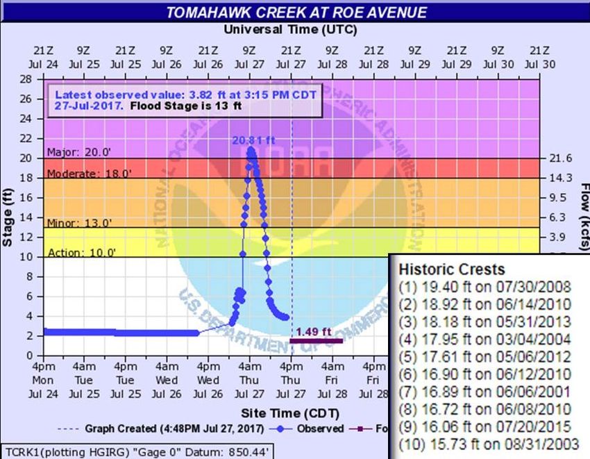
2017 Kansas Tornado Overview
Tornadoes:           60         2 below the 1950-2017 average of 62
                               35 below the past 30 year average of 95
                               32 below the past 10 year average of 94

Fatalities:          0         Injuries: 2
Longest track:                 26.64 miles (Pawnee to Barton counties, May 16)
Strongest:                     EF3 (Pawnee to Barton counties, May 16)
Most in a county:              5 (Barton)
Tornado days:                  15 (Days with 1 or more tornadoes)
                                                                                      Tornado in southwestern Gove County on
Most in one day:               14 (May 19)                                                        October 2, 2017.
Most in one month:             29 (May)                                                 Photo courtesy of Brandon Shahan.
First tornado of the year:     February 28 (Crawford County, 10:27 pm CST, EF0 0.1 mile length, 75 yard width)
Last tornado of the year:      October 6 (Pottawatomie County, 8:06pm CDT, EF1, 1.1 mile length, 40 yard width)
Length of tornado season:      220 days (Days between first and last tornado)

                          2017 Monthly Tornado Totals
   Month      Jan        Feb   Mar     Apr    May      Jun     Jul       Aug    Sep   Oct   Nov     Dec   Total
     EF5         0        0     0         0     0       0       0         0      0     0      0      0      0     0%
     EF4         0        0     0         0     0       0       0         0      0     0      0      0      0     0%
     EF3         0        0     0         0     1       0       0         0      0     0      0      0      1     2%
     EF2         0        0     0         0     0       0       0         0      0     1      0      0      1     2%
     EF1         0        0     1         2     2       1       0         0      0     4      0      0      8     13%
     EF0         0        2     8         4    26       1       1         0      0     8      0      0      50    83%
    Total        0        2     9         4    29       2       1         0      0    13      0      0      60    100%
   Percent     0    3.3   15.0     6.7    48.3   3.3     1.7     0       0     21.7   0      0
       Violent (EF4—EF5) in red, Strong (EF2-EF3) in yellow, Weak (EF0-EF1) in green. Monthly totals in gray.
                               (Percent values may not add to 100% due to rounding)

Annual Highlights: A total of 60 tornadoes occurred in Kansas in 2017,
which is near the long-term average (records beginning in 1950), but well
below more recent 10 and 20-year averages. Fortunately, no tornado-related
fatalities occurred in Kansas, but 2 injuries were reported. Both injuries oc-
curred on May 16th as an EF3 tornado tracked for 26.64 miles across Pawnee
and Barton counties. There were no violent tornadoes in Kansas last year.

The most active month in 2017 was May with 29 tornadoes observed. This is
98 tornadoes below the one-month record high (127 in May 2008). April,
May, and June, typically the core of the tornado season, were abnormally qui-
et in 2017. Tornado counts were 10, 9, and 20 below normal, respectively, for                 Tornado damage two miles west
each month.                                                                                    of Great Bend Airport on May
                                                                                                16, 2017. Photo courtesy of
                                                                                                       NWS Wichita.
The costliest Kansas tornado in 2017 was the EF3 tornado that moved across
Pawnee and Barton counties on May 16th. Damage was estimated at approximately $658,000.
                                    KANSAS SEVERE WEATHER AWARENESS WEEK
                                                MARCH 5-9, 2018
                                                               3
Kansas Tornado Statistics
                                          by County
                                      1950 - 2017
                         TORNADOES, FATALITIES, AND INJURIES

  County     Tor   Fat   Inj     County      Tor   Fat   Inj      County      Tor    Fat    Inj

   Allen      27    0      4   Greenwood     43     0    10      Pawnee       52      0     1
 Anderson     15    3     12     Hamilton    26     0      1     Phillips     41      0     1
 Atchison     15    0     11      Harper     62     0      1   Pottawatomie   34      1     5
  Barber      40    0      2      Harvey     49     1     63       Pratt       73     3     10
  Barton     101    2     40      Haskell    32     0     10     Rawlins       47     0      4
 Bourbon      19    0      7    Hodgeman     55     0      4      Reno         81     0     22
  Brown       45    0      5     Jackson     31     4     17    Republic       60     0      3
  Butler      80   28    225     Jefferson   40     0    101       Rice        47     0      6
  Chase       41    0      2
                                  Jewell     43     0      2      Riley        29     0     51
Chautauqua   19    0      0      Johnson     43     0     12      Rooks        52     0      6
 Cherokee    37    4     66       Kearny     45     0      0      Rush         52     0      8
Cheyenne     43    0      0      Kingman     67     0      1     Russell       78     1      7
                                   Kiowa     59    11     74      Saline       45     0     66
   Clark     40     0      0
                                  Labette    42     1     29      Scott        58     1      1
   Clay      43     1     31
  Cloud      50     1      8       Lane      47     0      2    Sedgwick       89    13    360
  Coffey     23     0      5   Leavenworth   30     2     30     Seward        38     0     15
Comanche     42     0      2      Lincoln    33     0      2    Shawnee        55    18    528
  Cowley     73    77    293        Linn     14     0      3    Sheridan       40     0      0
 Crawford    35     4     43      Logan      29     0      0    Sherman       110     0      0
 Decatur     47     0      5       Lyon      47     7    222      Smith        45     0      2
Dickinson    38     1     17      Marion     47     1      2     Stafford      72     3      5
 Doniphan     19   0      2      Marshall    33     0      1     Stanton       22     0      0
 Douglas      40   1     48     McPherson    54     1     16     Stevens       25     1      5
 Edwards      50   0      7       Meade      51     0      0     Sumner        84     5     14
     Elk      24   2      8        Miami     20     4     10     Thomas        46     0      1
    Ellis     62   0      6       Mitchell   48     0      5      Trego        63     5    101
 Ellsworth    50   0      0    Montgomery    34     1     1    Wabaunsee       38     1     26
  Finney      97   1     41      Morris      34     0     7      Wallace       35     0      4
    Ford     100   0      2      Morton      20     1     2    Washington      40     2     12
  Franklin    30   3     34     Nemaha       37     0     3      Wichita       35     0      4
   Geary      19   0      3     Neosho       31     0     4      Wilson        16     0      0
   Gove       58   0      3       Ness       53     0     4     Woodson       12      0     8
 Graham       41   0      0      Norton      30     0     0
   Grant      25   0      9                                     Wyandotte     10      2     36
                                 Osage       44    17     6
   Gray       50   0      3     Osborne      45     0    13
                                                                  Total
 Greeley     38    0      0      Ottawa      33     2    12                   4651   237   2926

                         KANSAS SEVERE WEATHER AWARENESS WEEK
                                     MARCH 5-9, 2018
                                               4
Kansas Tornado Facts
Days with more than 20 tornadoes
   Date          #Tornadoes            Kansas Tornado Count by Decade
     05/23/08            70                      1950s: 560
     04/14/12            43                      1960s: 457
     06/15/92            39                      1970s: 303
     05/05/07            36                      1980s: 339
     05/24/16            34                      1990s: 789
     06/04/55            33                      2000s: 1192
     05/29/04            28                      2010s: 634 (through 2017)
     10/26/06            28
     05/25/97            25
     06/09/05            25             Most Tornadoes in One Episode
     05/15/91            24             May 23, 2008     70 Tornadoes
     07/07/04            23             April 14, 2012   43 Tornadoes
     05/06/15            22             June 15-16, 1992 41 Tornadoes
     04/26/91            21

             KANSAS SEVERE WEATHER AWARENESS WEEK
                         MARCH 5-9, 2018
                                   5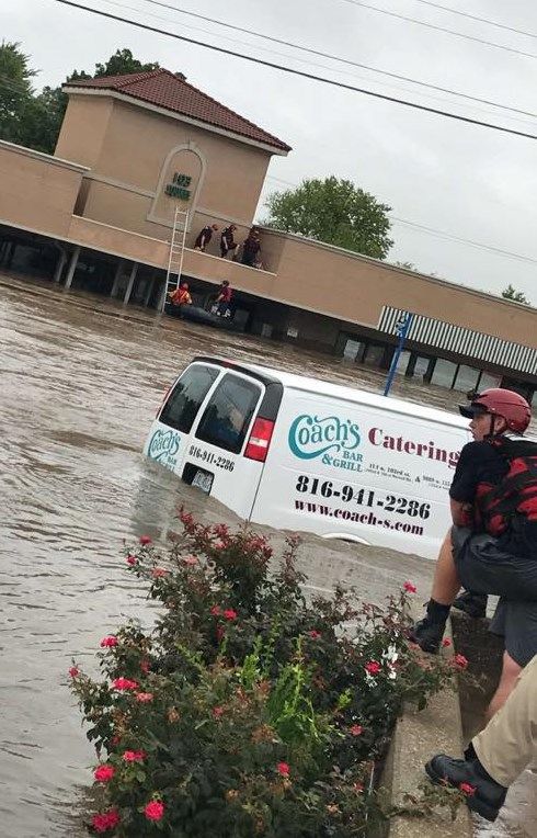
Did you know...
There are seven National Weather Service offices that serve portions of Kansas!
National Weather Service (NWS) offices in Kansas are located in Goodland; Dodge City; Wichita; Topeka;
Hastings, Nebraska; Pleasant Hill(Kansas City), Missouri; and Springfield, Missouri. Each office is staffed by
a team of highly trained meteorologists, technicians, electronics technicians, information technology special-
ists, hydrologists, and administrative assistants. The NWS offices are staffed 24 hours a day, seven days a
week, 365 days a year.
Contact the NWS office in your area to learn more about weather, weather safety, NOAA Weather Radio, of-
fice tours, or to learn more about careers in meteorology in the NWS or in NOAA.
The following pages contain 2017 Severe Weather Summaries for each NWS office.
Here is severe weather terminology you may encounter.
Severe Thunderstorm – The National Weather Service issues severe thunderstorm warnings for storms that
are currently, or are capable of, producing winds of 58 mph or stronger and/or hail one inch in diameter or
larger. Severe thunderstorms are often much stronger than this minimum criteria, so it is a good idea to take
severe thunderstorm warnings seriously.
Tornado – A tornado is a violently rotating column of air, in contact with the ground, either as a pendant
from a cumuliform cloud or underneath a cumuliform cloud, and often (but not always) visible as a funnel
cloud. A funnel cloud is a condensation cloud typically funnel-shaped and extending outward from a cumu-
liform cloud and is associated with a rotating column of air.
Flash Flood – A flash flood is flooding that occurs very rapidly, and usually within 6 hours of heavy rain-
fall. Flash flooding may occur along creeks, rivers or streams. It can also occur in low lying or urban areas
where drainage is poor. Water levels can rise very quickly during flash flooding including locations that did not
receive the heavy rainfall but are located downstream from areas that received an extreme amount of rainfall.
Flash flooding can occur in the winter months when rain falls on existing snowpack and causes it to melt
rapidly. Flooding is the number one severe weather killer in the U.S.
KANSAS SEVERE WEATHER AWARENESS WEEK
MARCH 5-9, 2018
6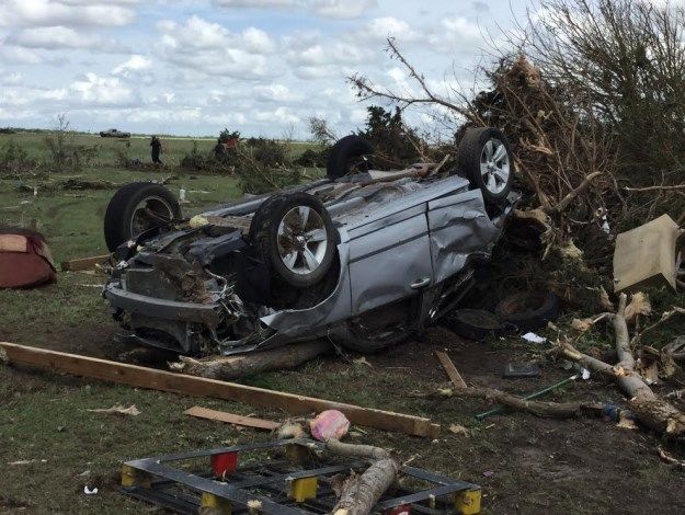
2017 Severe Weather Summary
                               Extreme East Central and Northeast Kansas
                               National Weather Service Pleasant Hill, MO
2017 saw numerous severe storms
move through far northeastern               2017 Far Northeast Kansas Severe Weather Stats
Kansas. Most notable of these                                  By The Numbers
storms were the March 6th super-
cells and squall line that produced    Number of Severe Wind, Hail, Flooding Reports: 163
numerous tornadoes across western      Tornado: 1 (EF-0) March 6, 2017
and central Missouri. Before these
storms moved out of Kansas one         Largest Hail: 2.85” (Johnson County) May 18, 2017
tornado occurred in Leawood, Kan-
                                       Most reports received: Johnson County (70)
sas, and produced minor damage.
More notable to the 2017 severe
weather season in far northeast Kansas was the widespread flooding that occurred in the mid to late summer.
Numerous flooding events brought significant damage to portions of the Kansas City (Kansas) Metro area,
which resulted in multiple water rescues. The most notable of these water rescues occurred on live television
on the morning of July 27th when several businesses were inundated with swiftly running water near the Kan-
sas and Missouri State Line along Indian Creek. Indian Creek in eastern Kansas experienced record flooding
more than once, as another round of heavy rain caused record flooding on August 21st, into the 22nd.

March 6, 2017: Large Hail, Strong Wind & EF-0 Tornado
                                                                     On the evening of March 6th, a line of
                                                                     severe thunderstorms formed, then
                                                                     moved into eastern Kansas, and western
                                                                     and central Missouri. Ahead of and along
                                                                     this line of storms, supercells formed and
                                                                     produced large hail, damaging winds, and
                                                                     several tornadoes; only one of which oc-
                                                                     curred in Kansas, an EF-0 tornado in
                                                                     Leawood, Kansas. Large hail up to 2.75
                                                                     inches occurred in DeSoto before the
                                                                     storms moved into Missouri. Strong
                                                                     winds did more widespread damage to
                                                                     portions of the Kansas City (Kansas)
                                                                     Metro than the isolated EF-0 tornado in
 A weak and brief tornado formed in Leawood on March 6. This EF-0    Leawood.
 tornado was the only tornado to form in 2017 in NWS Kansas City’s
                          Kansas counties.

                               KANSAS SEVERE WEATHER AWARENESS WEEK
                                           MARCH 5-9, 2018
                                                          7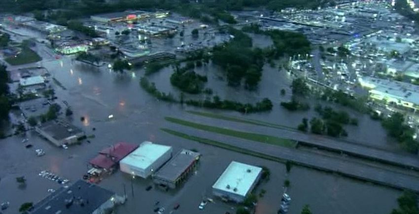
July 26-27, 2017 - Flash Flooding and Water Rescues in Kansas City
On the evening of July 26th, a line of thunder-
storms formed roughly along the Interstate 70 cor-
ridor. The orientation of these storms were such
that they trained over Kansas City and surrounding
areas for several hours causing some extreme flash
flooding. The heaviest rain hit some of the most
vulnerable parts of the city namely Indian Creek
near the Kansas and Missouri state line. At this
location, between 5 to 7 inches of rain fell over a
roughly 3 hour period causing Indian Creek at
State Line Road to rise to 27.96 feet, a new record
for that location. The result was businesses in that
area becoming inundated with several feet of wa-
ter. Numerous car dealerships along the Indian             Radar estimated rainfall on the evening and overnight hours
Creek bed had much of their merchandise go under-                                 of July 26-27
water. A strip mall consisting of a restaurant, among
other businesses, had water at least 6 feet deep. The restaurant owners tried to salvage their business but had
to flee to the roof in order to escape the rising waters around them. Local news televised a dramatic water res-
cue of the restaurant owners via motorized raft.

   Above: Numerous new and used vehicles were inundated by the swiftly
 flowing and quickly rising Indian Creek at 103rd and Wornall at the Kan-
     sas and Missouri State Line (Photo courtesy of KMBC Television).
   Right: A nearby restaurant was flooded to the rafters. The owners who
  showed up early in the morning were forced to take refuge in the ceiling
  and eventually the roof, where they were rescued from the swiftly flowing
              waters (Photo courtesy of Brittany Thomasson)
                                  KANSAS SEVERE WEATHER AWARENESS WEEK
                                              MARCH 5-9, 2018
                                                              8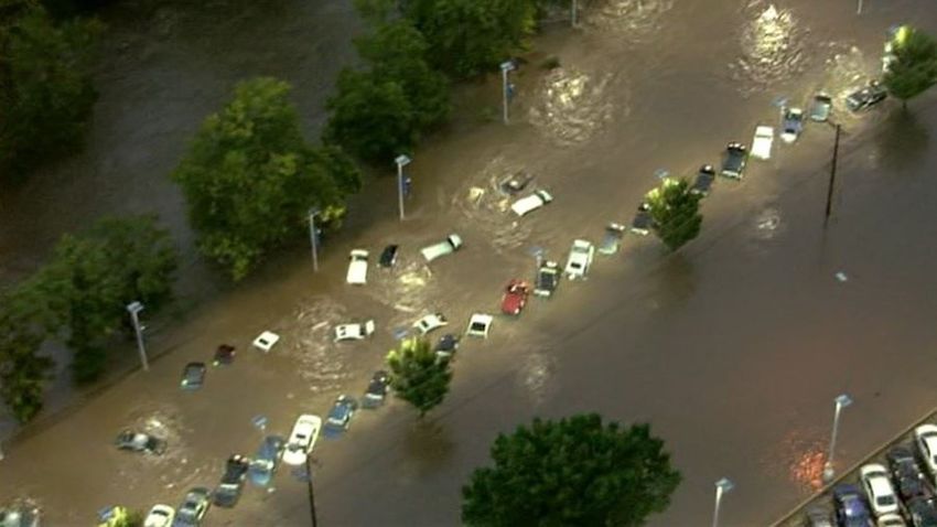
Indian Creek at State Line
was not the only site that
broke their highest flood rec-
ord. Tomahawk Creek at Roe
Avenue in Johnson County
Kansas also set an all time
record flood event.

                                        Aerial photograph of the 103rd and Wornall area, where Indian Creek cross the Kan-
                                                     sas-Missouri Stateline. Photo courtesy of KMBC Television.

  Indian Creek near State Line Road had record flooding          Tomahawk Creek near Roe Avenue had record flooding
  (27.96 feet) which caused damage to nearby car dealer-                           (20.81 feet).
                   ships and businesses.

August 21-22, 2017 - Flash Flooding and Water Rescues in Kansas City
From August 21st through the 22nd, multiple rounds
of heavy rain fell with widespread amounts of 4" to
6" and isolated reports of 8" to nearly 10". In addi-
tion to numerous roads and some schools closing
due to widespread flooding, the recently set record
crest made on Indian Creek at State Line Road was
broken. Other local stream records were broken as
well. Several water rescues were made overnight
Monday into Tuesday morning with one fatality due
to flooding. The fatality—the only known fatality
caused by severe weather in the Kansas City fore-
cast area— occurred on the east side of Highway 69
near 363rd Street in Miami County where deep rush-               24 –hour precipitation that fell on August 21-22, 2017
ing water was present.
                                KANSAS SEVERE WEATHER AWARENESS WEEK
                                            MARCH 5-9, 2018
                                                           9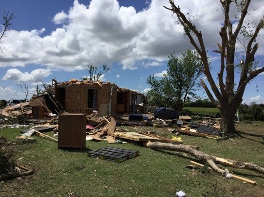
2017 Severe Weather Summary
                                       Northeast and East Central Kansas
                                      National Weather Service-Topeka, KS
Overall, the 2017 severe weather season was relatively benign for northeast and north central Kansas. Alt-
hough, the Topeka forecast area received a couple of high-impact events. These events ranged from several
tornadoes to widespread flash-flooding. The most notable event occurred August 21st, better known as the
“Total Solar Eclipse Day”, where several rounds of heavy rainfall produced upwards of 10 inches across
portions of Douglas and Franklin counties.
March 6th Tornadoes
A strong, early spring cold front traversed the central and northern Plains throughout
the day on March 6th. Boundary layer conditions ahead of the front consisted of
mixed-layer CAPE values near 1,000 J/kg with effective storm relative helicity values
approaching 200 m2/s2. Deep, boundary-layer mixing ahead of the cold front yielded
Lifting Condensation Level (LCL) heights on the order of 1,200 to 1,500 meters.
Semi-discrete thunderstorms developed along the surface cold front during the mid-
afternoon hours. Seven brief, weak tornadoes were documented across portions of
Flint Hills along Interstate 70. Several of the tornadoes neglected to have full conden-
sation throughout the funnel, similar to the image on the right. Not only were the tor-
nadoes difficult to spot due to the lack of full condensation, but a large grass fire was
ongoing ahead of the broken line of thunderstorms, further decreasing visibility in the area. Fortunately, only
minor damage was confined to outbuildings, powerlines and cropland irrigation.

June 15th–17th Severe Weather
                                  Mid-June marked an active severe weather period for portions of northeast
                                  Kansas. This three day stretch consisted of all severe hazards: large hail, dam-
                                  aging winds and a couple of tornadoes. Scattered thunderstorms developed
                                  across portions of central Kansas during the afternoon hours of June 15th,
                                  quickly moving east and southeast towards the Topeka County Warning Area
                                  (CWA). Upon entering the CWA, thunderstorms merged into linear segments
                                  with wind gusts upwards of 90 mph. Radar also suggested one or two Quasi-
                                  Linear Convective System (QLCS) tornadoes across the Flint Hills. Fortu-
                                  nately, damage reports were mainly confined to powerlines and trees. The
  th
16 consisted of a broken line of supercell thunderstorms pushing south from Nebraska producing large hail
up to the size of a tennis ball, winds upwards of 90 mph and one tornado near Beattie, Kansas. A similar sce-
nario occurred on June 17th, although supercell thunderstorms developed within the CWA during the after-
noon hours. Numerous reports of hail larger than golf ball size were reported across the area. Again most
damage during the three day severe weather episode was confined to outbuildings, trees and powerlines.

                              KANSAS SEVERE WEATHER AWARENESS WEEK
                                          MARCH 5-9, 2018
                                                       10
August 21st Flooding
While many were concentrating on the Total Solar Eclipse during the
early afternoon hours, portions of eastern Kansas were highlighted with
the potential for severe thunderstorms and flash-flooding. A cold front
was slowly pushing southward across the area during the late evening
hours of the 21st into the morning hours of the 22nd. A strong low-level
jet on the order of 35-40 knots ushered plentiful moisture into the area
throughout the aforementioned evening and overnight hours. As a result,
several rounds of thunderstorms were observed across east-central Kan-
sas between 9:00 PM and 7:00 AM. Numerous reports of 8 to 10 inches
of rainfall were reported across portions of southern Douglas and north-
ern Franklin counties. Several swift water rescues were required across
the area due to the quickly rising waters. However, the impressive rainfall amounts were not only confined to
Douglas and Franklin counties. Many areas along and east of a line from Holton to Burlington received 3 to 5
inches of rainfall. Numerous creeks and streams across east-central Kansas reach at least minor flood stage.
October 6th Tornadoes
For the second consecutive year, severe thunderstorms and tornadoes occurred in Kansas on October 6 th. The
2017 edition began with scattered supercell thunderstorms developing across portions of central Kansas during
the late afternoon hours. Upon entering the Topeka CWA, storms continued to exhibit rotation. While no torna-
does were reported in north-central Kansas, numerous damaging wind gusts were reported. One tornado was
reported near Olsburg, Kansas in Pottawatomie County. Fortunately, damage reports were confined to outbuild-
ings and trees.
Check out a Storm Spotter and Weather Safety Training
presentation near you this spring…
Each spring, the National Weather Service offices that serve the state of Kansas conduct storm spotter
and weather safety training sessions in most counties in the state. The sessions are free and open to the
public. You are not required to become a storm spotter nor will you have to take a test; however, the
presentations provide a great deal of information on severe weather in Kansas. They cover severe
weather safety and ways to get weather information from the National Weather Service. You can also
meet a meteorologist from your local National Weather Service office.
The schedule for storm spotter training sessions varies in each community, please check out
www.weather.gov and click on your location for more information on a training session in your area.
KANSAS SEVERE WEATHER AWARENESS WEEK
MARCH 5-9, 2018
112017 Severe Weather Summary
2017 Severe Weather Summary
Central, South Central & Southeast Kansas
Portions of Central, South Central and Southeast
National Weather Service - Wichita, KS
Kansas
January 13-16th Ice Storm
A significant ice storm impacted much of Kansas over the weekend of January 13-16th, 2017. Ice accumula-
tions of at least 0.25” were common with crippling amounts of 0.50-0.75” across portions of western and cen-
tral Kansas including communities such as Medicine Lodge, Great Bend, Russell and Dodge City. Needless
to say, tree and powerline damage was widespread, and slick roads led to numerous accidents. Approximate-
ly 4,000 homes were without power across Barton, Harper, Kingman and Rice counties.
Damage from 0.50" ice accumulation in Zenda.
March 4-6th Grass Fires Photo courtesy of Jodi Davis.
Fire danger concerns became elevated the weekend of March 4th with conditions worsening by March 6th.
The extreme fire danger was the result of very strong southwest to northwest winds in excess of 50 mph along
with very low relative humidity as low as 5%. Consequently, several large grass fires affected portions of
central and south-central Kansas March 4-6th.
On March 6th, fires approached the town of Wilson in Ellsworth County from the northwest forcing residents
to evacuate. Residents were eventually allowed back into their homes later that night. On March 5 th, a sec-
ond large grass fire flared up north of Hutchinson with valiant firefighting efforts containing about 90% of the
fire by early afternoon on the 6th. However, the fire rapidly flared back up during the early evening on the 6th
as winds switched to the northwest, and relative humidity values plummeted. This forced evacuations of
around 10,000 people along the far northern edge of Hutchinson.
KANSAS SEVERE WEATHER AWARENESS WEEK
MARCH 5-9, 2018
12Grass fires north of Hutchinson. Grass fires north of Hutchinson. Photo courtesy of KAKE.
Photo courtesy of KWCH.
April Rainfall and Flooding
A slow-moving, upper-level low pressure system brought significant rainfall to southeast Kansas and espe-
cially the Ozarks region starting on Friday April 28th and continuing into April 30th. A few locations across
southeast Kansas picked up around 5 inches of rain through this event, with some areas of southern Mis-
souri receiving over 10 inches or rainfall. The heavy rainfall caused numerous streams and rivers to flood.
This same storm system brought significant snowfall to parts
of western Kansas which is extremely rare late April.
Near major flood stage was observed along the Neosho River near
Oswego late April into early May.
KANSAS SEVERE WEATHER AWARENESS WEEK
MARCH 5-9, 2018
13May 16th Barton County Tornadoes
Storms developed over western Kansas and Oklahoma Panhandle during the afternoon hours of May 16 th.
One supercell thunderstorm tracked northeast out of far southwest Kansas and persisted for a few hours.
This storm rapidly intensified as it approached southwest Barton County producing an EF2 tornado that
struck Pawnee Rock and eventually produced EF3 damage west and northwest of the Great Bend Airport.
This storm continued to the northeast producing additional damage before lifting northwest of Hoisington.
The tornado was on the ground for 27 miles, and two minor injuries were reported. Another brief tornado
occurred northeast of Susank; this tornado touched down in an open field and did not produce any damage.
(Above Left) EF3 damage around 2 miles west/northwest of the Great Bend Airport.
(Above Right) EF2 damage on west side of Pawnee Rock.
May 18th Severe Storms
Storms rapidly developed over western Oklahoma and
central Kansas during the afternoon hours of May 18th
along a warm front that was situated generally near I-
70. A few of these storms produced brief tornado
touchdowns and damaging winds. The most severe
damage occurred just west of Salina in and around the
Salina Speedway from a tornado-warned storm.
From May 18: Damage at the Salina Speedway, west of
the Salina Airport.
Photo courtesy of Dusty Wiegert.
June 15th Severe Storms
Storms developed over central Kansas during the late afternoon
hours of June 15th and rapidly became severe due to extreme in-
stability in place. After the storms developed they tracked south-
east into the evening hours leaving a path of destructive winds
and large hail across central and south central Kansas. Wide-
spread tree damage was reported along with power outages due to
60-80 mph winds. There were a few injuries in Hutchinson when From June 15: Supercell and lightning bolt west
of Kingman, KS.
a large tree fell on a vehicle. Photo courtesy of Matt Crowther.
KANSAS SEVERE WEATHER AWARENESS WEEK
MARCH 5-9, 2018
142017 Severe Weather Summary
2017 North Central
Severe Kansas
Weather Summary
National Weather Service - Hastings, NE
A severe weather season of typical length, but lacking
any signature severe weather events, could be one way
to describe the 2017 north central Kansas severe weather
season.
Prior to the normal severe weather season, extreme fire
weather conditions reared its head on March 6th. A wild-
fire fanned by high winds, warm temperatures and
fueled by dry grasses, rapidly torched several thousand
acres of prairie in Rooks County. This was part of the
worst wildfire day in Kansas history during which over
650,000 acres of land burned across the state.
Thunderstorm-related severe weather started in mid-
April when golf ball to tennis ball sized hail covered
Highway 128 near Burr Oak. In mid-May, winds of 70
mph ripped through Phillips and Smith counties down-
ing trees, power lines and taking the roof off a restaurant
in Phillipsburg.
The main summer months were littered with hail, wind
and heavy rain events. June 13th brought hail causing
sporadic crop damage across several locations including
parts of Phillips, Smith and Osborne counties. Phillips
county again recorded strong winds over 60 mph with
thunderstorms in early July and mid-August, but little
damage was reported. Unfortunately, after a wet spring,
the lack of shower and thunderstorm activity through the
summers months left north central Kansas at a moisture
deficit by fall.
Golf ball size hail near Webster State Park on June 15th.
When it comes to tornadoes, 2017 didn’t exactly stand Photo provided by Butch Post.
out either. Only one tornado was confirmed for the year
and that didn’t occur until October 1. A brief EF-0 rated rope tornado occurred in far northwest Rooks County
around 7:00 PM , but no damage was reported. Damage did likely occur nearby in Phillips and Smith counties
where half-dollar to baseball sized hail was reported near Agra and Kensington. A week later, hail the size of
golf balls fell near Hunter and that essentially ended the 2017 severe weather season.
KANSAS SEVERE WEATHER AWARENESS WEEK
MARCH 5-9, 2018
152017 Severe Weather Summary
Southwest Kansas
National Weather Service - Dodge City, KS
January 14-16 Ice Storm
After a very dry fall, 2017 started out with an extreme
weather event! A major ice storm occurred across much of
the area on January 14th into the 16th. The amount of
moisture that fell and the ice accretions were excessive for
this storm. Although the buildup of ice was not as great as
the December 2006 ice storm, the damage to trees and sub-
sequently power lines that centered on Dodge City was ex-
treme. Many reasons contributed to tree damage through-
out southwest Kansas, including the weakened condition of
trees due to the drought of 2011, insect damage that fol-
lowed the drought and the fact that there had not been sig-
nificant icing in the decade preceding this storm. Unfortu-
nately it appears that this ice storm contributed in some
part to the devastating wild fires that occurred in early March.
Extensive tree damage occurred during the Jan. 14-16 ice storm.
Early March Wildfires
On March 6th, many devastating wildfires erupted across parts of Kansas, Oklahoma and Texas. Many fires
were started by downed power lines as a result from weakened connections from the January ice storm. The
fire in Ford County was the result of a brush pile in Dodge City that had not been fully extinguished before
the dry, warm winds began.
The largest and most costly fire occurred across Clark County. There were seven separate fires! Two
moved near or through Englewood, originating in Oklahoma. Another consumed several homes just north
of Ashland.
KANSAS SEVERE WEATHER AWARENESS WEEK
MARCH 5-9, 2018
16Four other fires in northern Clark County consumed several
homes initially and became a monster fire as a cold front
moved through. The fires subsided during the first night but
flared up the following late morning and afternoon on the
7th. Livestock losses may have been as many as 9,000 head.
Total acres burned in just Clark County were estimated at
447,000. There were 31 homes destroyed and 6 damaged.
There were a total of 108 outbuildings destroyed and 13
others damaged. Many, many miles of fence were de-
stroyed. Early damage was estimated at $3 million.
On the same day in Lane and Ness counties, a wildfire start-
ed after a power line disconnected from an outbuilding and
fell to the ground. The fire spread very fast with the high winds; this fire burned three dozen outbuildings and
damaged or destroyed thousands of fence posts and burned at least 20,000 acres. In Hodgeman County, a fire
quickly spread from 50 to 60 mph winds. The ignition point north and west of Jetmore was the result of a
downed power line. The fire consumed several homes and buildings. Total acres burned were approximately
18,000.
In Comanche County, a fire threatened Protection, and the town was evacuated twice but never had damage
within the city limits. Although the fires subsided late on the 6th, the fire flared again by late morning on the
7th.In Ford County, a fire started at a burn pile near the racetrack in Dodge City. The fire burned at least two
dozen structures, fences, trees and several vehicles. It initially spread northeast and then quickly turned east
and southeast as a cold front moved through the area.
Late April Snow
It did finally start raining later in March, decreasing the
threat of wildfires. The moisture was definitely a blessing.
Then, winter returned late in April. An intense upper
storm moved from the Four Corners region and interacted
with unseasonably cold air to produce a major blizzard
across western Kansas with snowfall amounts of 12 to 24
inches. Cattle loss across western Kansas was estimated to
be as many as 100,000 head. One electric company alone
had around $75 million in damages to its infrastructure,
and it will take at least 3 years to fully repair. This unusu-
al, late-spring storm was made more destructive by the
weight of the snow since it was very wet and driven by 50
to 60 mph wind gusts. All roads across the western fourth
of the state were closed and impassable for one to two
days.
KANSAS SEVERE WEATHER AWARENESS WEEK
MARCH 5-9, 2018
172017 Severe Weather
As far as severe weather goes, there were the typical
days of hail and high winds. The number of torna-
does during 2017 was about half of what normally
occurs. Only 16 were reported and most did not
cause any damage. The strongest tornado started in
Pawnee County on May 16th and caused EF3 dam-
age as it crossed into Barton County. The last torna-
do to occur in our area during the year was on Octo-
ber 2 in Scott County. It caused EF2 damage.
In August, there were several severe hail and wind
storms. The first storm occurred around Kiowa lo-
cated in Barber County on the 5th causing at least $3
Hail swath from the August 10th storm
million in damage. Hail also accompanied the wind.
Two days later, 80 mph winds and softball sized hail pummeled the earth, as well as a few automobiles just
west of Medicine Lodge, also in Barber County. The following day on the 10th, another very severe hail and
wind storm occurred across Trego County. Devastation was extreme! Property was heavily damaged by
hail bigger than softballs, accompanied by winds stronger than 70 mph. In addition, there was a tremendous
toll done to wildlife. The hail was so bad that days after the storm, the scaring of the ground could easily be
seen from a satellite view.
2017 Precipitation
The majority of the area was above normal for precipitation for 2017 despite a two-month dry period from
mid-January through mid-March as well as having an extremely dry fall and early winter to round out the
year. For instance, at Dodge City it
was the wettest start on record
(back to 1875) from January 1st
through May 24th. In addition,
spring (March 1 through May 31)
was the 2nd wettest on record at
Dodge City. Unfortunately what
followed by late summer was little
to no moisture to finish out 2017.
The 95 day period from October 7th
through January 10th, 2018 pro-
duced only 0.01” of rain at Dodge
City – the driest 95 day period on
record. Similar conditions were
observed throughout the High
Plains region.
KANSAS SEVERE WEATHER AWARENESS WEEK
MARCH 5-9, 2018
182017 Severe Weather Summary
Northwest Kansas
National Weather Service - Goodland, KS
As with every spring and summer across the High Plains, severe weather once again plagued the region.
However, the 2017 severe weather season was generally quiet in terms of tornadic activity. Thirteen torna-
does were confirmed across the Tri-State Region via reports or NWS storm surveys; this count is well below
the yearly average of 23 since 1990. The weather-related damage in 2017 was primarily done by wind, hail
and winter weather.
Damaging Winter Weather Events
Two significant winter storms struck the High Plains this year. The
first winter storm arrived January 15th and persisted through the 16th.
For northwest Kansas, this was a rare breed of winter storm as the
main impact was freezing rain and substantial ice accumulations.
Widespread reports of one quarter of an inch to one inch of ice were
received. Several locations lost power due to power lines collapsing
under the weight of the ice. The last time an ice storm of this magni-
tude struck the region was on December 10-11th, 2007.
While the January ice storm significantly impacted western Kansas
particularly southwestern portions of the state, the late April blizzard
dwarfed the ice storm in terms of damage for northwest Kansas. The
winter storm began on April 29th with rain changing to snow. Snow
was slow to accumulate initially due to warm ground temperatures
Semi stuck in the snow - 5/1. and mixed
Photo courtesy of Becky Klippert
precipitation
of rain and snow. However, as temperatures fell and
precipitation intensified, a complete change to snow
was observed. Conditions rapidly deteriorated on the
morning of April 30th as heavy snow and high winds
ramped up. Blizzard conditions persisted for approxi-
mately the next 12 hours across northwest Kansas. Re-
ports of visibility near zero, wind gusts between 50
and 65 mph and snow totals over one foot were com-
mon. The highest snow total was along the Wallace
and Logan County line where 28 inches were reported
by emergency management. . Satellite image of remaining snow - 5/1.
Photo courtesy of College of Dupage
KANSAS SEVERE WEATHER AWARENESS WEEK
MARCH 5-9, 2018
19Even though the April blizzard left a band of snow only about 100 miles wide, the destruction within that
band was immense. Thousands upon thousands of power poles were snapped due to the high wind and the
weight of the wet snow. Power was not returned to some locations for more than a week. All major roads
through northwest Kansas were closed during the storm. Motorists passing through barricades quickly be-
came stranded, and the National Guard rescued trapped travelers from deep snow drifts. A couple of their
more capable winter weather vehicles got stuck in the snow around Colby, Kansas due to the extreme nature
of this storm. As a result of the widespread significant damage, President Donald Trump signed a federal
disaster declaration for all thirteen northwest Kansas counties in the NWS Goodland forecast area.
Severe Weather
Storm approaching Goodland, KS - 5/26. Photo courtesy of Britny Lynch
The 2017 severe weather season got off to a relatively slow start primarily due to dry weather and a lack of
significant severe-producing systems. This is not to say the region was completely devoid of severe weather.
The first severe report of the year was quarter sized hail in southern Gove County on April 15 th, and the first
tornado of the year occurred southeast of Kanorado in Sherman County on April 27th.
The traditional spring severe season (May and June) brought only a few “outbreaks” of severe weather. The
most notable outbreak occurred on May 25th and 26th as several rounds of supercell thunderstorms moved
across northwest Kansas. These storms primarily produced quarter to baseball sized hail and wind gusts of
60 to 100 mph. Four tornadoes (two in Sheridan County and two in Yuma County Colorado) and flash flood-
ing also occurred during this severe weather outbreak.
June 2017 was fairly quiet in terms of significant severe weather. Well-above normal rainfall was observed,
and many locations benefitted from the heavy rain. Some locations benefitted too much as flash flooding did
become a problem at times. Only two reports of hail greater than two inches were received during the month,
which is not bad at all for the peak of severe weather season when hail can exceed baseball to softball size.
An even more surprising fact is that no tornadoes were observed during the month.
The dry spell for northwest Kansas tornadic activity was finally broken after 56 days. On July 21 st, a large
landspout tornado developed in northeastern Cheyenne County between Bird City, KS and Benkelman, NE.
The landspout remained over open country resulting in no damage. Other than breaking the long tornado
drought, this tornado is also notable because it grew to over one quarter mile wide at times.
KANSAS SEVERE WEATHER AWARENESS WEEK
MARCH 5-9, 2018
20The next severe weather outbreak occurred on August
10th. Weather conditions became very unstable across
western Kansas by the early afternoon hours, and thun-
derstorms rapidly developed. Two in particular were
quite significant. The first storm developed in Cheyenne
County and marched southeast. While the storm was
slow to get going, it intensified over Sheridan County
eventually producing softball sized hail and 100 mph
wind gusts. The storm continued to produce significant
severe weather as it continued southeast into Graham,
Gove, and Trego counties. The town of WaKeeney was
hit particularly hard by this storm. Due to the winds and
hail: crops were decimated, trees and power lines were
Crop damage southeast of Hoxie, KS on August 10.
snapped, farm outbuildings were blown down, and windows Photo courtesy of Jaclyn Carter
and roofs were destroyed on well-built structures.
A second storm developed in northern Sherman County shortly afterwards. The storm also moved southeast
and impacted Goodland with baseball sized hail. In the course of 11 months, the town of Goodland observed
hail larger than two inches in diameter three separate times (September 15th, 2016; May 26th, 2017; August
10th, 2017).
The final severe weather event of the year took place on October 1st and 2nd. A boundary stalled across west-
ern Kansas allowing severe thunderstorms to move northeast into northwest Kansas over a couple consecutive
evenings. On October 1st, one storm produced three inch hail in Sheridan County and a couple tornadoes in
Graham County. A stronger storm moved from Scott County to Gove County on October 2 nd producing hail
to the size of golf balls, four tornadoes, torrential rain and flash flooding in Gove County. The same storm
also produced tornadoes in Scott County covered by NWS Dodge City. A fifth brief tornado occurred in
southeastern Greeley County. The most notable tornado on October 2nd was the tornado which impacted the
town of Quinter. This tornado developed near
the elementary school, moved northeast and
eventually exited town. The tornado damaged
several structures, homes and numerous trees.
A quonset collapsed as a result of the damage
it sustained. Damage primarily consisted of:
snapped tree trunks and limbs; downed power
poles; broken windows to businesses, homes
and vehicles; downed fencing; roofing material
removed from structures; a flipped trailer; and
Tornado southeast of Tribune, KS on October 2nd. a mobile home blown off its support.
Photo courtesy of Max Olson
KANSAS SEVERE WEATHER AWARENESS WEEK
MARCH 5-9, 2018
21Tornado in southwest Gove County on October 2nd. Photo courtesy of Brandon Shahan
All in all, the severe weather season for northwest Kansas was about normal. However, this season was defi-
nitely odd in terms of the low number of tornadoes (11 in northwest Kansas) and the long tornado drought
during the height of the severe season. Severe weather season often brings images of large, violent tornadoes
to mind; this 2017 season brought memories of a tremendous blizzard, a few significant wind-driven hail
events, well-above normal rainfall and flash flooding.
2017 Severe Weather Summary
Southeast Kansas
National Weather Service - Springfield, MO
Relatively Quiet Year Across Far Southeast Kansas
2017 started out with perhaps the most costly storm of the year as an ice storm downed trees and power lines
across southeast Kansas in mid-January. Only two tornadoes touched down in 2017 with both being rare win-
ter “cool season” tornadoes as they touched down on February 28th in Crawford County. Fortunately, both
tornadoes were weak as winds were less than 100 mph and damage was mainly to outbuildings in the Farling-
ton and Helpler areas. This same event produced golf ball sized hail that damaged cars in Cherokee County.
One of the more remarkable storms was a straight line wind event that produced 80 to 90 mph winds in Craw-
ford and Bourbon counties in early March. It wasn’t until May when significant severe storms produced hail
to the size of golf balls once again in Cherokee County.
Otherwise, there were numerous other storms and flash floods throughout the year, but only minor impact
were noted.
KANSAS SEVERE WEATHER AWARENESS WEEK
MARCH 5-9, 2018
22KANSAS SEVERE WEATHER AWARENESS WEEK
MARCH 5-9, 2018
23Do you have a
NOAA Weather Radio?
What is it? Where do you get a NWR?
NOAA Weather Radio (NWR) broadcasts National You can buy receivers at many retail outlets such as
Weather Service warnings, watches, forecasts and electronics, department, sporting goods, and boat and
other hazard information 24 hours a day. marine accessory stores and their catalogs as well as
online at: http://www.nws.noaa.gov/nwr/info/
How does it notify you? nwrrcvr.html#residential
Weather radios equipped with a special alarm tone
How much does it cost?
feature can sound an alert and give you immediate
Prices vary from $20 up, depending on the model.
information about a life-threatening situation.
During an emergency, NWS forecasters will send
Options for those with special needs?
out a special tone to activate weather radios in the
The hearing- and visually impaired can get these
listening area.
warnings by connecting weather radios with alarm
tones or other such as strobe lights, pagers, bed-
shakers, personal computers and text printers.
Public safety experts agree: a NOAA Weather Radio
should be standard equipment in every home.
Lightning Safety
If you hear thunder, you are Outdoor Activities: Minimize the
risk of being struck by moving indoors
within striking distance. Seek
or to the inside of a vehicle
safe shelter IMMEDIATELY!
Inside Activities: Things to avoid
Corded phones
Computers
Other electrical equipment
Indoor pools
Tubs and showers and other
things connected to metal
KANSAS SEVERE WEATHER AWARENESS WEEK
MARCH 5-9, 2018
24You can also read