REPORT OF INVESTIGATION INTO AN INCIDENT OFF THE NORTH COAST OF SPAIN INVOLVING THE IRISH REGISTERED YACHT - 'LOA ZOUR' - Marine Casualty ...
←
→
Page content transcription
If your browser does not render page correctly, please read the page content below
REPORT OF INVESTIGATION
   INTO AN INCIDENT
OFF THE NORTH COAST OF
  SPAIN INVOLVING THE
IRISH REGISTERED YACHT
      ‘LOA ZOUR’
 ON THE 6th JUNE 2019

 REPORT NO. MCIB/300
   (No.10 OF 2020)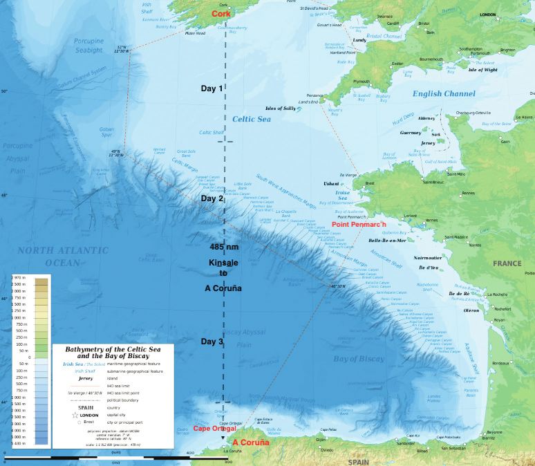
The Marine Casualty Investigation Board (MCIB) examines and investigates all types of marine
casualties to, or on board, Irish registered vessels worldwide and other vessels in Irish territorial
waters and inland waterways.

The MCIB objective in investigating a marine casualty is to determine its circumstances and its
causes with a view to making recommendations to the Minister of Transport - for the avoidance
of similar marine casualties in the future, thereby improving the safety of life at sea and inland
waterways.

The MCIB is a non-prosecutorial body. We do not enforce laws or carry out prosecutions. It is not
the purpose of an investigation carried out by the MCIB to apportion blame or fault.

The legislative framework for the operation of the MCIB, the reporting and investigating of
marine casualties and the powers of MCIB investigators is set out in the Merchant Shipping
(Investigation of Marine Casualties) Act, 2000.

In carrying out its functions the MCIB complies with the provisions of the International Maritime
Organisation’s Casualty Investigation Code and EU Directive 2009/18/EC governing the
investigation of accidents in the maritime transport sector.
Leeson Lane, Dublin 2.
Telephone: 01-678 3485/86.
    email: info@mcib.ie
         www.mcib.ie

                                       REPORT OF INVESTIGATION
                                          INTO AN INCIDENT
                                       OFF THE NORTH COAST OF
                                         SPAIN INVOLVING THE
                                       IRISH REGISTERED YACHT
                                             ‘LOA ZOUR’
                                        ON THE 6th JUNE 2019

 The Marine Casualty Investigation
 Board was established on the
 25th March 2003 under the
 Merchant Shipping (Investigation
 of Marine Casualties) Act, 2000.

 The copyright in the enclosed
 report remains with the Marine
 Casualty Investigation Board by
 virtue of section 35(5) of the
 Merchant Shipping (Investigation
 of Marine Casualties) Act, 2000. No
 person may produce, reproduce or
 transmit in any form or by any
 means this report or any part
 thereof without the express             REPORT NO. MCIB/300
 permission of the Marine Casualty         (No.10 OF 2020)
 Investigation Board. This report
 may be freely used for educational
 purposes.
                                                                 1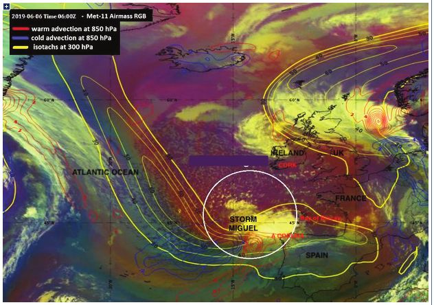
Glossary of Abbreviations and Acronyms

    AIS              Automatic Identification System
    BBC              British Broadcasting Corporation
    CGR              Coast Guard Radio
    CoP              Code of Practice: The Safe Operation of Recreational Craft (2017)* Note 1
    DSC              Digital Select Calling
    EPIRB            Emergency Position Indicating Radio Beacon
    ETA              Estimated Time of Arrival
    GMDSS            Global Maritime Distress and Safety System
    GPS              Global Positioning System
    IMA              Irish Maritime Administration
    IMO              International Maritime Organisation
    IRCG             Irish Coast Guard
    LOA              Length Overall
    LUT              Local User Terminal* Note 2
    Met              Meteorological
    MMSI             Maritime Mobile Service Identity
    MN               Marine Notice
    MSO              Marine Survey Office
    ROC              Restricted Operators Certificate
    SART             Search and Rescue Radar Transponder
    S.I.             Statutory Instrument
    UK               United Kingdom
    UTC              Co-ordinated Universal Time
    VHF              Very High Frequency
    WNWS             Worldwide Navigational Warning Service.

    Kilometres               km
    Kilowatts                kW
    Litres                   (lts)
    Metres                   m
    Nautical miles           NM
    *Note 1: Updates to the Code of Practice: The Safe Operation of Recreational Craft 2017 (Marine Notice
    No.51 refers) were published in November 2019. The updates can be downloaded in electronic format at:
    https://www.gov.ie/en/publication/66ff7e-safe-operation-of-recreational-craft/

    *Note 2: COSPAS-SARSAT ground stations are called Local User Terminals (LUTs). These satellite receiving
    units are the ground stations that receive emergency beacon (EPIRB) distress alerts. Once a signal is
    received and processed at the LUT it is transmitted to the mission Control Centre (MCC) that operates that
    particular LUT. The LUTs are fully automated and completely unmanned at all times.
    NOAA manages and operates three-types of LUTs. Low Earth Orbit LUTs (LEOLUTs), Medium Earth Orbiting
    LUTs (MEOLUTs) and Geostationary Earth Orbit LUTs (GEOLUTs) all track, receive and process alerts.
    (courtesy of the National Oceanic and Atmospheric Administration (NOAA))

    Report MCIB/300 published by the Marine Casualty Investigation Board.
    Produced 14th December 2020.

2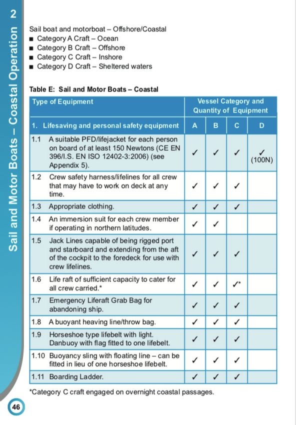
CONTENTS

                                                       PAGE

1.   Summary                                              4

2.   Factual Information                                  5

3.   Narrative                                           10

4.   Analysis                                            19

5.   Conclusions                                         22

6.   Safety Recommendations                              23

7.   Appendices                                          24

8.   MSA 2000 Section 36 - Correspondence Received       42

                                                              3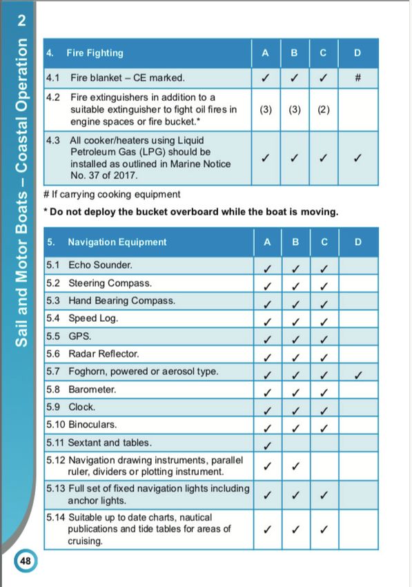
SUMMARY

    1.     SUMMARY

    1.1    The yacht ‘Loa Zour’ sailed with five crew onboard from Kinsale, Co Cork on the
           3rd June 2019 with an intended destination of A Coruña, northern Spain. As the
           yacht approached the north coast of Spain on the 6th June the yacht’s crew
           issued a Mayday broadcast and activated the vessel’s Emergency Position
           Indicating Radio Beacon (EPIRB) as they experienced severe difficulties in storm
           force conditions from Storm Miguel. The crew were airlifted from the yacht by a
           Spanish Maritime Rescue helicopter (Salvamento Alvamento Maritimo) and taken
           ashore to A Coruña airport.

    1.2    The yacht ‘Loa Zour’ was located adrift two days later and boarded by the crew.
           The yacht was subsequently navigated into the port of A Coruña.

    Note: Times from local reports assumed to be local time = UTC +2

4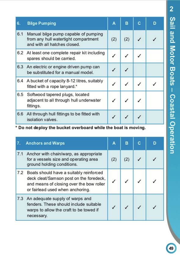
FACTUAL INFORMATION

2.         FACTUAL INFORMATION

2.1        Vessel Details

           Name:                     ‘Loa Zour’

           Type:                     Bermudan sloop sailing vessel with auxiliary engine.

           Category:                 Category ‘B’ – Offshore. Under 13.7 metres (m) length.
                                     (reference: Code of Practice: The Safe Operation of
                                     Recreational Craft (2017).

           Overall Length:           13 m

           Breadth:                  3m

           Hull materials:           Glass Reinforced Plastic (GRP).

           Registry:                 Irish

           Call Sign:                EIOM5

           MMSI No:                  250002926

           (See Appendix 7.1 Photograph No.1 Yacht ‘LOA ZOUR’).

2.2        Vessel Safety Equipment

           The yacht ‘Loa Zour’ is a recreational craft and comes within the legislative
           requirements, terms and recommendations contained within the Code of
           Practice: The Safe Operation of Recreational Craft (2017)1 referred hereinafter as
           the ‘Code of Practice’ or ‘CoP’. The yacht ‘Loa Zour’ is 13 m overall length and
           considered a Code of Practice category ‘B’ vessel.

           Vessels in category ‘B’ would generally be expected to be in excess of 7 m in
           length and be capable of undertaking offshore passages of between 50 and 500
           miles and withstand seas up to 4 m in height and winds up to Beaufort Force 8
           (Gale). The yacht ‘Loa Zour’ was 13 m in length. The Code of Practice (CoP)
           recommendation for sailboats less than 13.7 m in length is that safety equipment
           carried onboard should reflect the boats function and sea area of operation. A
           voyage from Kinsale to A Coruña would transit offshore sea areas A1 and A2 and a
           vessel making this voyage is recommended to have onboard additional
           radiocommunications equipment as described in the CoP , Appendix 2, Guidance
           Notes on Radiocommunications.

      1. Updates to the Code of Practice: The Safe Operation of Recreational Craft 2017 (Marine Notice No.51 refers) were
         published in November 2019. The updates can be downloaded in electronic format at:
         https://www.gov.ie/en/publication/66ff7e-safe-operation-of-recreational-craft/

                                                                                                                            5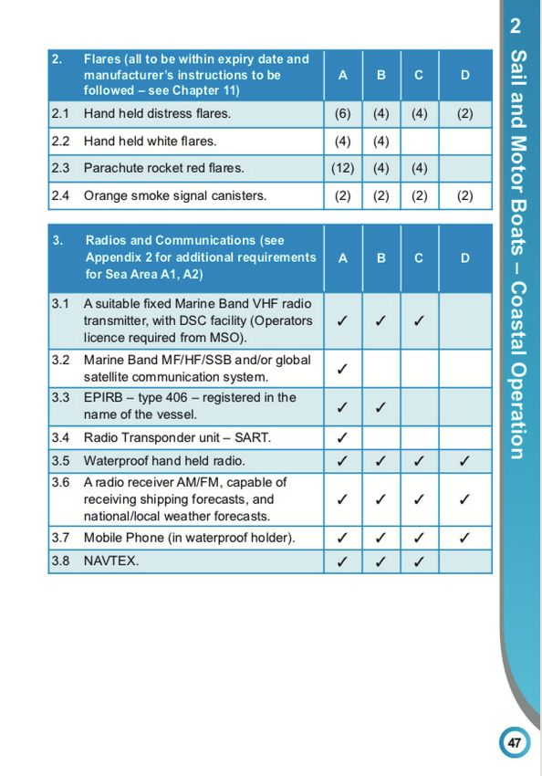
FACTUAL INFORMATION                   Cont.

          The CoP also sets out the recommended type and quantity of equipment that
          should routinely be carried onboard yacht ‘Loa Zour’ as a category B vessel and
          as described in Chapter 2, Table E:

          • Lifesaving and personal safety equipment, as per section 1, paragraphs 1.1 to
            1.3 and 1.5 to 1.11.

          • Flares as per section 2, paragraphs 2.1 through to 2.4.

          • Radios and Communications as per section 3, paragraphs 3.1 through to 3.8.

          • Fire Fighting equipment as per section 4, paragraphs 4.1 through to 4.3.

          • Navigation Equipment as per section 5, paragraphs 5.1 through to 5.10 and 5.12
            through to 5.14.

          • Bilge Pumping equipment as per section 6 paragraphs 6.1 through to 6.6.

          • Anchors and Warps as per section 7, paragraphs 7.1 through to 7.3.

          • General Equipment as per section 8, paragraphs 8.1 through to 8.11.

          (See Appendix 7.4 Fig. 10, Fig.11 and Fig.12 Code of Practice Table E sections 1
          to 8).

          The Skipper stated that he had prepared a year in advance for the voyage to Spain
          and had the required safety equipment. The liferaft was serviced in 2018 and was
          in date at the time of the incident. In addition the Skipper purchased a sea anchor
          suitable for a vessel the length of yacht ‘Loa Zour’. A sea anchor is an underwater
          drogue or parachute device that is streamed from a boat in heavy weather to
          stabilise the vessel and to limit its drift through the water. It may be streamed
          from the bows or the stern and will tend to align the vessel to wind and waves.

          (See Appendix 7.1 Photograph No.3 Deployment of a Sea Anchor).

          The yacht had a suite of navigation aids including two sets of global positioning
          systems (GPS), a chart plotter and NAVTEX receiver (www.navionics.com). The
          yacht was also fitted with a vessel Automatic Identification System (AIS)
          transceiver with its unique Marine Mobile Service Identity (MMSI) number. AIS is an
          automatic tracking system that uses transceivers on ships and small craft and is
          used by Vessel Tracking Services (VTS).

    2.3   Voyage particulars

          The planned voyage of yacht ‘Loa Zour’ from Kinsale to A Coruña would transit
          the following UK Met Office designated sea areas south of Kinsale to north coast
          of Spain:

6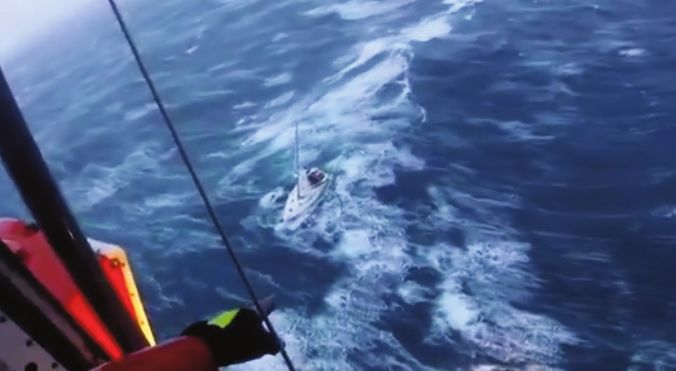
Cont.   FACTUAL INFORMATION

      • The ‘Fastnet’ is the sea area immediately south of Ireland.

      • ‘Sole’ is the sea area that includes the western approaches to the English
        Channel and the south west approach to the Irish Sea.

      • ‘FitzRoy’ is the area of sea in the eastern side of the North Atlantic Ocean
        that includes the south western approaches to the Channel and lies west of
        the Bay of Biscay and the north coast of Spain.

      (See Appendix 7.2 Fig.2 UK Met Office ‘Sea Areas’).

      • The Bay of Biscay is a gulf off the Northeast Atlantic Ocean and located
        south of the Celtic Sea. It lies along the western coast of France from Point
        Penmarc’h, Finistére, to the Spanish border and the northern coast of Spain
        and west to Cape Ortegal and is known in weather forecasting as sea area
        ‘Biscay’. The Bay is known for its rough seas and violent storms due for the
        most part to its exposure to the Atlantic Ocean and the continental shelf
        which extends for some distance into the Bay resulting in relatively shallow
        waters in many areas.

      (See Appendix 7.2 Fig.1 Bay of Biscay).

      Voyage Plan: The Skipper of yacht ‘Loa Zour’ reported that his intention on the
      3rd June 2019 was to sail from Kinsale in the afternoon of the 3rd June and
      make course for the port of A Coruña located on the north west coast of Spain.
      The Skipper’s voyage plan was to make a direct crossing of the sea areas west
      of the Bay of Biscay, a distance of approximately 485 nautical miles (NM) due
      south.

      The voyage plan was discussed by the Skipper with the crew and the planned
      estimated time of arrival at A Coruña was calculated as being sometime on the
      7th June 2019, i.e. the fifth day of the voyage.

      Close relatives of the crew were aware of the details of the voyage and
      estimated day of arrival at the port of A Coruña. A Passage Plan was not made
      or submitted to a shore based authority.

2.4   Crew Details

      Skipper/Owner of yacht ‘Loa Zour’ - Previous experience in the Merchant Navy.
      Extensive sailing experienced both coastal, offshore and some ocean passages.
      Holder of an Irish Sailing Association Yachtmaster Coastal Skippers Certificate
      of Competency qualification (not seen).

      Crew member A – Extensive sailing experienced both inshore, offshore and
      some ocean passages, boat owner.

                                                                                        7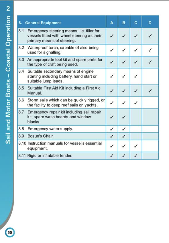
FACTUAL INFORMATION                  Cont.

          Crew member B – Extensive experience inshore sailing and boat owner.

          Crew member C – Experienced yacht racer, no qualifications.

          Crew member D – Some yachting experience, no qualifications.

    2.5   Marine Incident Information

          Incident Type: This incident involved the Irish registered yacht ‘Loa Zour’ which
          is normally located in Irish waters and under the control of a resident of the
          State, in international waters contiguous to Irish waters, with five crew persons
          onboard. The incident posed a threat of death or serious injury to the crew, the
          loss or serious damage to the vessel and risk to the rescuers.

          This was a marine casualty as defined in Part 1, Section 2 of the Merchant
          Shipping (Investigation of Marine Casualties) Act, 2000.

    2.6   Weather Information

          The Skipper obtained weather forecasts from Met Éireann and two internet wind
          and swell forecasting services prior to departure from Kinsale on the 3rd June.

          (See Appendix 7.2 Fig.8 Met Éireann Sea Area forecasts and Coastal Reports 3rd -
          4th June).

          The Skipper also made reference to Windy.com, a weather forecast visualisation
          tool which makes use of weather forecasting models in order to show wind speed
          and directions of weather systems worldwide. This tool also has a predictive
          feature. On the 3rd of June the Skipper used this tool to obtain a forecast of the
          weather and winds for the next five days.

          The Skipper reported that the Met Éireann forecast was similar to the Windy.com
          forecast in that winds would increase in strength from Wednesday 5th June into
          Thursday 6th June indicating that a weather front was passing through their
          planned voyage route. The Skipper did not consider the forecast to be abnormal
          for June.

          Yacht ‘Loa Zour’ also carried onboard a NAVTEX, (NAVigational TEleX) receiver
          which is an international information system for delivery of navigational and
          meteorological warnings and forecasts, as well as urgent maritime safety
          information to ships. NAVTEX weather warnings are (in an abbreviated form)
          similar to the shipping forecasts. The NAVTEX was working in screen readout only,
          the printer function being out of service. The Skipper was not monitoring the
          NAVTEX and was not aware of any of the crew in particular monitoring the NAVTEX
          readouts throughout the voyage.

8
Cont. FACTUAL INFORMATION
2.7 Emergency Response Timeline
Times from local reports assumed to be local time = UTC +2.
On the evening of the 6th June 2019, yacht ‘Loa Zour’, with five crew onboard,
encountered Storm Miguel 85 NM off the north coast of Spain. The yacht was
disabled by the storm conditions and at approximately 20:00 hours (hrs) local
time the Skipper of yacht ‘Loa Zour’ assessed that the crew were in grave danger
and made the decision to broadcast a Mayday. The radio operator, crewmember
‘A’, made several Mayday VHF broadcasts over approximately thirty minutes
which was answered by an oil tanker. The reception was very poor and
transmissions broken and garbled. The Skipper was later informed by
crewmember ‘A’ that he thought the Mayday was received but was unable to
confirm with the tanker. There was no further contact with or from the tanker
whose identity remains unknown at this time.
At approximately 20:30 hrs the Skipper activated the vessel’s EPIRB which was
detected by the International Satellite System for Search and Rescue (COSPAS-
SARSAT) system and directed to the regions Local User Terminal (LUT)2. The
Skipper reported that he was contacted directly by VHF radio by an English
speaking operator and assumed the operator was calling from the UK.
(See Appendix 7.3 Fig.9 COSPAS-SARSAT system overview).
The Spanish Maritime Rescue (SMR) agency received notification from the COSPAS-
SARSAT LUT that the yacht ‘Loa Zour’ was in distress off the north coast of Spain
and was informed of the yachts EPIRB position and Maritime Mobile Service
Identification (MMSI) number. At approximately 20:50 hrs the Skipper of the yacht
reported that the Spanish Coast Guard, also known as Spanish Maritime Rescue
(SMR), contacted the crew by VHF radio, shortly after they had activated the
EPIRB, to inform them that a rescue helicopter was on its way to their location.
The helicopter arrived shortly thereafter.
The Skipper reported that the rescue helicopter operator informed him that the
yacht’s unpredictable movements made an unsuitable platform for a rescue and
therefore required the crew to enter the seas one at a time in order to be
airlifted directly from the sea.
The crew closed down the yacht (engine stopped, battery switches to ‘Off’ and
all hatches closed) before they abandoned the yacht as directed by the rescue
helicopter crew and were airlifted to safety. The rescue helicopter proceeded to
the airport at A Coruña. The crew of the yacht ‘Loa Zour’ were uninjured. The
yacht was afloat but abandoned and adrift off the north coast of Spain.
2. COSPAS-SARSAT ground stations are called Local User Terminals (LUTs). These satellite receiving units are the ground stations that
receive emergency beacon (EPIRB) distress alerts. Once a signal is received and processed at the LUT it is transmitted to the
mission Control Centre (MCC) that operates that particular LUT. The LUTs are fully automated and completely unmanned at all
times.
9NARRATIVE
3. NARRATIVE
3.1 Voyage Departure
On Monday the 3rd June at approximately 18:00 hrs yacht ‘Loa Zour’ sailed from
its homeport of Kinsale, Co. Cork for a voyage to the port of A Coruña, on the
north coast of Spain. The Skipper estimated a four to five day passage and had
made all preparations that he thought necessary for a foreign going voyage
across the Bay of Biscay and along the north coast of Spain.
3.1.1 The Skipper and crew had discussed a plan for the voyage which he stated took
into account the basic contingencies such as route, distance and time, weather
forecasts, safety equipment, contact information and safe place of refuge.
• Route. The voyage was planned to depart Kinsale and set course for A Coruña,
a voyage distance of approximately 485 NM and expected to take
approximately five days. Estimated day of arrival was the 7th June.
• Weather forecasts. The Skipper checked out the weather forecast obtained
from a variety of services including Met Éireann and two internet weather
forecasting tools, WINDY.com and another which he could not recall the name.
Met Éireann forecast provided coastal weather radio forecast information for
the first twenty four hours of the voyage. Met Éireann also provides an
internet service Atlantic chart for air mass precipitation and pressure
information forecast for the next seven days.
The two other internet weather forecast tools gave wind and swell forecast for
the five days crossing. The Skipper’s weather forecast predicted a weather front
passing through the region from the North Atlantic but winds would reach Force
6 to 7 at most on Thursday the 6th June by which time the yacht was expected
to be nearing the Spanish coast.
While it was apparent from these forecasts that a gale was due in from the
Atlantic to cross the Bay of Biscay around Wednesday the 5th and Thursday the
6th June the Skipper stated that none of these forecasting tools gave him any
indication that the gale would develop into a storm.
• Safety Equipment. The Skipper had a prepared checklist of safety equipment
he considered necessary for a voyage of this nature.
• Charts and sailing directions and the vessels log book were onboard and in use
and the crew were familiar with the boat and the operation of its equipment.
• Contact Information. Family members of the Skipper and crew were aware of
the voyage plan, its estimated time of voyage and expected confirmation on
the yachts arrival in A Coruña.
10Cont. NARRATIVE
• Safe refuge in the event of bad weather. The course of action in the event of
bad weather was to head west into the refuge of the North Atlantic Ocean
until the bad weather subsided.
3.1.2 The Skipper stated he was unaware of the Government publication, Code of
Practice: The Safe Operation of Recreational Craft and the CoP recommendation
for passage planning. He was also unaware of Marine Notice 9 of 2003
‘Application of SOLAS Chapter V to Recreational Craft. Both these publications
are made freely available for download on the Irish Government’s Department
of Transport (DoT) website (www.gov.ie/transport). The CoP recommended
passage planning template illustrated in Appendix 6 of the Code was therefore
not used and no recorded Passage Plan was made or submitted to the relevant
authority (Irish Coast Guard (IRCG)).
Marine Notice (MN) 9 of 2003 - Application of SOLAS Chapter V to Recreational
Craft, highlights the SOLAS regulations applicable to small, privately owned
recreational craft such as yacht ‘Loa Zour’.
(See Appendix 7.4 Fig.13 and Fig.14 MN 9 of 2003 Pages 1 and 2).
The first section of MN 9 of 2003 details the SOLAS Chapter V Regulation 34 ‘Safe
Navigation and Avoidance of Dangerous Situations’. Regulation V/34 concerns
prior-planning for a boating trip also known as voyage or passage planning and
makes particular reference, amongst other requirements, to the following
regarding passage planning:
• Weather: check the weather forecast and get regular updates if planning to be
out for any length of time.
• Limitations of the vessel: consider whether the boat is up to the proposed trip.
• Crew: take into account the experience and physical ability of the crew.
• Contingency plan: always have a contingency plan should anything go wrong.
Consider places where the boat can take refuge should conditions deteriorate.
• Information ashore: make sure someone ashore knows what to do should they
become concerned for the crews wellbeing. The IRCG has a yacht and boat
safety scheme and all vessels planning to sail offshore are encouraged to
submit a sail plan before commencing the voyage.
3.1.3 The Skipper had considered the requirements for the voyage and made diligent
preparations as he thought best. However, the Skipper was not aware of the
requirements in detail for passage planning or the regulations for passage
planning as listed above in paragraph 3.1.2. Passage planning as a subject, is
included in the ISA Yachtmaster Coastal syllabus.
11NARRATIVE Cont.
(See Appendix 7.4 Fig.15 ISA Yachtmaster Coastal Sea based Course (Sail)
syllabus).
3.2 Safety Equipment
The CoP recommendation for category ‘B’ sailboats less than 13.7 m in length is
that safety and radiocommunications equipment carried onboard should reflect
the boats function and sea area of operation. Chapter 2, Sail and motor boats –
Coastal Operation, recommends storm sails which can be quickly rigged, or a
facility to deep reef sails on yachts (8.6). While the yacht had the facility to
deep reef its sails the crew did not have sufficient time to rig storm sails of any
description.
(See Appendix 7.4 Fig.12 CoP Table E Section 8).
Appendix 2 of the CoP sets out Guidance notes on Radiocommunications for
category B craft – Offshore relating to Sea Area A1 and Sea Area A2. A direct
crossing of the Bay of Biscay would transit Sea Area A1 (communications range
approximately 30 NM from a coastal radio station) and Sea Area A2
(communications range approximately 150 NM from a coast radio station):
SEA AREA A1: The following equipment should be installed on category B craft
when operating in Global Maritime Distress and Safety System (GMDSS) Sea Area
A1:
• A fixed type-approved VHF installation capable of transmitting Digital
Selective Calling (DSC) on channel 70 and radiotelephony on at least channels
16, 13 and 6.
• A VHF DSC watchkeeping receiver on channel 70.
• A type-approved satellite EPIRB.
• A hand-held type-approved waterproof VHF unit with an onboard charging
facility or spare batteries.
• A type-approved Search and Rescue Transponder (SART).
• A Navigational Telex (NAVTEX) receiver.
SEA AREA A2: In addition to the equipment required for Sea Area A1 , the
following equipment should also be fitted on the craft when operating in Sea
Area A2:
• A position fixing system capable of providing continuously updated positional
data to the DSC and Satcom equipment (e.g. GPS).
• A Medium Frequency (MF) radiotelephone installation capable of receiving and
transmitting DSC on 2187.5 kHz and a MF watch keeping receiver capable of
transmitting on DSC 2187.5 kilohertz (kHz).
Or alternatively, an INMARSAT ship earth station capable of SatCom C, SatCom M
or Mini-M communications.
12Cont. NARRATIVE
The Skipper was not aware of the additional equipment as recommended in the
CoP Chapter 2, Table E (list of equipment) for operating in sea areas A1 and A2
and the yachts radiocommunication equipment was deficient in respect of:
• A SART (Sea Area 1).
• An MF radiotelephone installation with watchkeeping function OR
alternatively an INMARSAT ship shore radio telephone (Sea Area 2).
Although yacht ‘Loa Zour’ was not equipped with a SART, the vessels AIS system
would have enabled search and rescue services identify and locate the yacht.
3.3 Weather Forecasting Services
3.3.1 Met Éireann’s weather forecasting service reports coastal weather around the
coast of Ireland between Latitudes 51° and 56° North and 5° and 11° West.
Met Éireann also offers a 7 day Atlantic air mass forecast chart which shows
forecast pressure and precipitation every 6 hours for seven days across the sea
areas in the western Atlantic. This is an internet service and unavailable to users
once they are offshore any great distance. It was unavailable to the crew of
yacht ‘Loa Zour’ after leaving the coast of Ireland.
3.3.2 The internet weather application tool Windy.com shows wind directions and
wind force in visual form for this area. Again these tools are unavailable once
the user is any great distance off shore and was unavailable to the crew of yacht
‘Loa Zour’ after leaving the coast of Ireland.
3.3.3 NAVTEX is an international automated direct printing service for delivery of
navigational, meteorological and maritime safety information to ships fitted
with a receiver. The receiver operates on the medium radio frequencies.
Information is received aboard ships at sea within approximately 370 km or 200
NM range off shore. The receiver has a direct printing capability as well as a
real-time screen readout function giving the latest weather forecast update.
NAVTEX weather forecasts are presented in abbreviated format similar to the
shipping forecasts and is a major element of the GMDSS and a component of the
International Maritime Organisation’s (IMO) Worldwide Navigational Warning
Service, (WNWS). Yacht ‘Loa Zour’ was fitted with NAVTEX. The automated
direct printing function (which would have given the crew a printout of the
latest weather forecast update and a historical perspective of the changing
weather conditions up to that time), was not in service. The screen readout
function was operating and would have displayed on screen the latest weather
update but the crew were not pro-actively monitoring the NAVTEX screen
readouts during the voyage.
13NARRATIVE Cont.
3.3.4 The UK meteorological service MetOffice (metoffice.gov.uk/services) provides
weather Shipping Forecasts covering the North Atlantic eastern seaboard. The
forecasts are divided into a series of Sea Areas. The Shipping Forecast is
broadcast three times daily by the British Broadcasting Corporation (BBC) Radio
4 service in FM, MW and LW (156.0 to 162.5 MHZ and 1600 to 2300kHz) radio
frequency ranges. This information could be heard and monitored on an AM/FM
radio receiver and would appear in NAVTEX weather information transmissions.
Both means of weather forecasting were onboard and available to the crew of
yacht ‘Loa Zour’ on the voyage.
(See Appendix 7.2 UK Met Office Shipping Sea Areas Chart).
The voyage plan was to transit through sea areas Fastnet, Sole and FitzRoy in
that order.
A synopsis of the UK Met Office Shipping Forecasts for sea areas Fastnet, Sole,
Biscay and FitzRoy from the yachts day of departure (3rd June) to the day of the
crew’s rescue (6th June) was as follows:
Monday 3rd June, the yacht ‘Loa Zour’ day of departure.
At 11:30 UTC 03 June for the next 24 hours:
Lundy, Fastnet, Irish Sea: Southwesterly 4 to 6 becoming cyclonic 2 to 4,
moderate or rough.
Sole: Southwesterly veering northwesterly 3 to 5, occasionally 6 in the east,
moderate or rough.
FitzRoy: Southwesterly veering westerly 4 to 6, but variable 3 or less at first in
south. Moderate or rough.
There were no gale warnings for these sea areas at this time.
Tuesday 4th June, yacht transiting sea areas Fastnet, Sole.
At 11:30 UTC 04 June for the next 24 hours:
Lundy, Fastnet: Cyclonic becoming Northwest, 5 or 6, moderate occasionally
rough.
FitzRoy, Sole: Northwest 5 or 6, occasionally 7 at first, moderate or rough.
There were no gale warnings for these sea areas at this time.
Wednesday 5th June, yacht passing point of no return as it transits sea areas
Sole to FitzRoy.
At 11:30 UTC 05 June for next 24 hours:
Sole, Lundy, Fastnet: West 3 or 4, occasionally 5 at first, becoming variable 3 or
less, moderate or rough.
14Cont. NARRATIVE
FitzRoy: West 4, becoming variable 3 or less in north, but cyclonic 5 to 7,
occasionally gale 8 later in south, moderate or rough.
There was a gale warning at issued at 1001 UTC; FitzRoy gale force 8 expected
later.
Thursday 6th June, yacht transiting sea area FitzRoy, approaching the north
coast of Spain, Bay of Biscay to the East.
At 11:30 UTC 06 June for next 24 hours:
Biscay, FitzRoy: Cyclonic 7 to severe gale 9, increasing storm 10 at times,
perhaps violent storm 11 later, rough or very rough, occasionally moderate at
first, then becoming high at times.
There was a gale warning issued at 04.01 GMT; FitzRoy – Southwesterly gale
force 8 increasing severe gale force 9 imminent then veering northwesterly and
increasing storm force 10 later. Biscay – Westerly storm force 10 expected later
(See Appendix 7.2 Fig.3, Fig.4, Fig.5 and Fig.6 UK Met Office Shipping Forecasts
3rd – 6th June).
The weather forecast for Wednesday 5th June was the earliest indication of gale
force conditions in sea Area FitzRoy available to the crew. Also on 5th June,
AEMET, the Spanish Metrological Agency, named a rapidly developing low
pressure system developing out in the Atlantic as ‘Storm Miguel’. Over the next
couple of days this extratropical cyclone developed in a rapid cyclogenesis
process and produced a quick formation of a deep low-pressure centre in the Bay
of Biscay. The cyclone (Storm Miguel) tracked across north west Spain and
Portugal on the 6th June before sweeping north across the Bay of Biscay to the
Atlantic coast of France on the 7th June. The storm conditions produced by
Storm Miguel was attributed to the loss of a French fishing boat with the crew
assumed dead and the capsize of a French rescue lifeboat off the French coast
with the loss of three lifeboat crewmembers on the 7th June.
(See Appendix 7.2 Fig.7 Storm Miguel – 0600 UTC 06th June. Satellite image
(Meteosat-11)).
3.4 Weather and Sea Conditions Experienced by the Crew of Yacht ‘Loa Zour’
The Skipper reported that for the first two days (3rd and 4th June), the weather
was as per the 3rd June weather forecasted by Met Éireann and WINDY.com.
On the third day, 5th June, the wind was more than forecasted and the crew
were required to reef in the main sail and furl the jib sail.
The fourth day, 6th June, started fine as the wind dissipated although the sea
swell was rough between 3 to 4 m high. The crew unfurled the sails and dried
15NARRATIVE Cont.
out their sailing gear. However, in the afternoon the wind increased quickly to
an estimated Force 8 and the crew furled the sails again. The Skipper mistakenly
thought this was the predicted weather front coming through. The wind abated
but again rapidly increased in force and by the late afternoon was gusting to 60
knots and the Skipper estimated Beaufort Force 10 storm conditions. The
Skipper did not expect the weather conditions to deteriorate so rapidly. The
Skipper reported that the crew managed to reef the sails but the main sail was
reduced to tatters, as was the jib sail shortly after. The cockpit spray hood was
also destroyed. The crew deployed a sea anchor from the bows but had
insufficient warps available to utilise the sea anchors full effect and the anchor
was damaged beyond use. The engine was unable to maintain headway and the
yacht was often beam on to the breaking seas which were very high with
overhanging, breaking crest and heavy rolling. The crew sought refuge inside the
yacht as the vessel was uncontrolled at this point and experiencing very heavy
rolling and violent movements. The Skipper reported that the yacht was
uncontrolled, beam on to the sea and on its beam ends on occasions. Water was
entering the cabin and the crew were being thrown about and in close danger
of serious injury. The weather and sea conditions experienced by the crew of
yacht ‘Loa Zour’ off the north coast of Spain on the 6th June was due to Storm
Miguel.
(See Appendix 7.1 Photograph 2 Yacht ‘Loa Zour’ in Storm Miguel seas (courtesy
of Salvamento Maritime)).
3.5 Crew Rescue
On the 6th June 2019, shortly before 20:30 hrs the Skipper of yacht ‘Loa Zour’
assessed that the crew were in grave danger and took the decision, on advice
from his crew, to broadcast a Mayday. Crewmember ‘A’ operated the VHF radio.
The Skipper stated that after several Mayday transmissions over approximately
thirty minutes they were answered by a crewmember of an oil tanker. The
reception was very poor and transmissions broken and garbled. The Skipper was
later informed by crewmember ‘A’ that he thought the Mayday was received but
was unable to confirm. There was no further contact with or from the tanker
whose identity remains unknown.
At approximately 20:30 hrs the Skipper activated the vessel’s EPIRB which was
detected by the COSPAS SARSAT system and directed to the regions Local User
Terminal (LUT). The Skipper reported that he was contacted directly by VHF
radio by an English speaking operator who may have been the LUT duty operator
and assumed the operator was calling from the UK.
(See Appendix 7.3 Fig.9 COSPAS-SARSAT system overview).
The Spanish Maritime Rescue (SMR) agency received the notification from the
COSPAS-SARSAT LUT that the yacht ‘Loa Zour’ was in distress off the north coast
16Cont. NARRATIVE
of Spain and gave the yacht’s EPIRB position and unique MMSI number. At
approximately 20:50 hrs the Skipper of the yacht reported that the Spanish
Coast Guard, also known as Spanish Maritime Rescue (SMR), contacted the crew
by VHF radio, shortly after they had activated the EPIRB, to inform them that a
rescue helicopter was on its way to their location. The helicopter arrived shortly
thereafter.
The Skipper reported that the rescue helicopter operator informed him that the
yacht’s unpredictable movements made an unsuitable platform for a rescue and
therefore required the crew to enter the seas one at a time in order to be
airlifted directly from the sea.
The crew closed down the yacht (engine stopped, battery switches to ‘Off’ and
all hatches closed) before they abandoned the yacht as directed by the rescue
helicopter crew and airlifted to safety. The rescue helicopter proceeded to the
airport at A Coruña. The crew of the yacht ‘Loa Zour’ were uninjured. The yacht
was afloat but abandoned and adrift off the north coast of Spain.
3.6 Rescue Weather and Sea Conditions
According to Spanish reports and EUMETSAT data, winds experienced along this
coast and attributed to Storm Miguel were between 60 and 80 knots, well in
excess of Beaufort Force 10 (storm force). Spanish Salvamiento Maritimo
reported wave heights between four to six metres with multiple breaking crests
and wind speeds of 60 knots. The Skipper estimated the waves as being in excess
of 15 m (trough to peak) with breaking crests and breakers midway down the
troughs. The Skipper recounted that steering was tied and the crew had retired
into the yacht’s accommodation spaces while the Skipper kept a look-out from
the hatchway coaming. He saw the yacht’s mast dipped into the seas twice with
the severe rolling of the vessel and the crew were thrown around the yachts
interior before he made the assessment that the crew were in imminent danger
of injury and instructed the radio operator, crewmember ‘A’, to broadcast a VHF
radio Mayday distress broadcast. The Skipper states that several Mayday
broadcasts were made before they received a response from an oil tanker but
the reception was very poor and garbled and crewmember ‘A’ was not sure the
call was understood. The crew received no other response to their Mayday voice
transmissions and the Skipper decided to activate the vessels EPIRB. He reported
that shortly after activating the EPIRB they received a VHF transmission from the
Local User Terminal (COSPAS-SARSAT), the location of this LUT has not been
verified. The Skipper reported that after activating the EPIRB they received
another VHF transmission from the Spanish Coast Guard informing the crew that
a rescue helicopter was en-route to their location.
A report credited to Salvamento Maritimo states that “the seas were too rough
to attempt a rescue (helicopter) direct from the boat which was (moving)
dangerously”. The crew were required to jump into the seas one by one in order
to be rescued by the helicopter. Maritime Rescue said “winds of 60 knots and
17NARRATIVE Cont.
waves from four to six metres made the task/rescue very complicated”. The
Maritime Rescue helicopter landed the crew at A Coruña airport where the crew
were checked over medically, completed formal immigration processes and
found accommodation in a local hotel. There were no injuries to the crew.
3.7 Recovery of Yacht ‘Loa Zour’
The whereabouts of yacht ‘Loa Zour’ after the crew rescue was unknown for
approximately two days. The yacht had been abandoned and adrift 85 NM north
west of A Coruña. The Skipper recounts that two days after the rescue, on the
8th June, the Spanish Coast Guard informed him the yacht had been spotted 80
km (43NM) off the Spanish coast. By that time Storm Miguel had passed through
the region and advanced northwards.
The Skipper chartered a local boat in order to locate and recover the yacht
which was eventually found and boarded by the five crewmembers. The Skipper
recounts that there was an amount of water in the cabin up to the bottom of
the companionway steps. Contents of lockers including food, bedding, charts,
log books, nautical publications and personal items were in the bilge water and
beyond recovery. However, some key systems were working and the crew were
able to pump out the water and start the engine. The crew navigated the yacht
to the port of A Coruña.
.
18ANALYSIS
4. ANALYSIS
4.1 As a category ‘B’ Offshore vessel being in excess of 7 metres in length, yacht
‘Loa Zour’ would generally be expected to be capable of undertaking an
offshore passage assuming weather and sea conditions on passage did not
exceed gale force, i.e. Beaufort Force 8, and seas over 4 m heights. Yacht ‘Loa
Zour’ encountered storm force conditions in excess of Beaufort Force 10 and
reported wave heights (4 to 6 m). These conditions were beyond the yachts
design capacity as a category ‘B’ offshore vessel.
4.2 The five crewmembers were experienced yacht sailors, three having offshore
sailing experience and the other two crewmembers were familiar with the boat
and had some sailing experience. The three most experienced crewmembers
were themselves boat owners. Collectively the crew were competent sailors and
capable of an offshore voyage under normal circumstances. The Skipper stated
that he had a Yachtmaster Coastal (sail) Certificate of Competency (CoC) and
was in the process of logging qualifying sea time to enable his application for
assessment for the Yachtmaster Offshore CoC. The Irish Sailing Associations
training syllabi for both CoC qualifications include the following subject matter:
• Passage Planning.
• Preparations for Offshore passages.
• Heavy weather sailing and preparations
(See Appendix 7.4 Fig.15 ISA Yachtmaster Coastal sea-based course (Sail)
syllabus).
The above subjects are mentioned in MN 9 of 2003 as part of SOLAS Chapter
V/34 requirements for recreational craft. The Skipper did not heed the
recommendations or requirements of SOLAS Chapter V/34 preparations for the
offshore voyage in so far as:
• There was no Passage or Voyage Plan made or submitted to the relevant
authority.
• The crew did not monitor the BBC weather forecasting services for weather
updates provided by the UK Met Office shipping forecasts or NAVTEX weather
information transmissions during the voyage and immediately prior to the
onset of Storm Miguel when weather conditions quickly deteriorated.
• The yacht was operating in the margin of Offshore to Ocean conditions and
therefore close to the limits of the yacht’s radiocommunications equipment
and design category ‘B’ capability and in that:
19ANALYSIS Cont.
- the voyage from Kinsale to A Coruña would transit through Sea Areas A1
and A2 and be at the extreme communications range from any coastal
radio stations, (approximately 30 NM for A1 and approximately 150 NM for
A2) and skirted the eastern Atlantic Ocean at the voyages mid-point. The
yacht’s radio communications equipment was not to the scale as
recommended for voyages in Sea Areas A1 and A2 and may have reduced
the Skipper’s options either in the event of medical emergency to the
crew or a breakdown of the yacht.
The Bay of Biscay is notorious for its rough seas and violent storms due to its
proximity to the North Atlantic Ocean. A strong gale (Beaufort Force 9) would
have exposed the yacht to sea conditions beyond its category ‘B’ capability.
Even though Storm Miguel was unexpected because it developed during the
warm season the Skipper did not consider the limitations of the vessel in the
event of bad weather.
- The contingency plan for a very bad weather event was to head
westwards into the Atlantic Ocean. This plan was weak for two reasons:
(1) The plan assumed the crew would have sufficient weather forecasting
notice to enable a course change in time to make sufficient distance
to avoid deteriorating sea and weather conditions.
(2) The plan did not take into account the category ‘B’ offshore vessel
capability limitations of the yacht, (recreational craft designed for a
wind force up to and including Force 8, and significant wave height
up to and including 4 m). A course change into the Atlantic Ocean
would have likely exposed the vessel to conditions beyond its design
capability.
• Yacht ‘Loa Zour’ was operating beyond its design category ‘B’ capability and
the crew of yacht ‘Loa Zour’ did not have sufficient experience or training
or the necessary competence to adequately prepare for the voyage and
ultimately to withstand the extreme weather and sea conditions presented
by Storm Miguel.
4.3 The UK Met Office Shipping Forecast for the 5th June, sea area FitzRoy included
a gale warning Force 8. The Shipping Forecast was available to the crew as they
made the mid-voyage crossing point that day by listening to the BBC Radio 4 AM
radio transmissions and observing the NAVTEX readouts. Even if the crew had
been aware of the gale warning, the capability of the yacht and competencies
of the crew were just sufficient to withstand a gale and enable the voyage to
continue to A Coruña.
20Cont. ANALYSIS
The cyclone that rapidly formed into Storm Miguel developed from the 5th June
in the North Atlantic. Storm Miguel was unusual because it developed during a
warm season.
The cyclone rapidly worsened in the North Atlantic and made its approach
towards the north coast of Spain. The UK Met Office Shipping Forecast at 11:30
hrs UTC 6th June for sea area FitzRoy was considerably worse than the previous
day’s forecast. The forecast predicted that the previously forecast gale force 8
of the 5th June would become cyclonic to severe gale force 9, increasing storm
force 10 at times, perhaps violent storm force 11 later.
This forecast was critical information for the crew of the yacht who were now
beyond the voyages half way or mid-point and, on the morning of the 6th June,
the crew of the yacht remained unaware of, and therefore unprepared for, the
extreme weather approaching from the Atlantic.
Storm Miguel landed on the north Spanish coast as the yacht was within a one
days sailing distance from A Coruña in the late afternoon of the 6th June. Too
late, the Skipper and crew realised their predicament when the yacht
encountered the storm force conditions 85 NM from A Coruña. The crew were
unprepared and the only course of action for the Skipper and crew was to
weather the storm as best they could.
4.4 The radiocommunications equipment onboard the vessel was not to the CoP
recommended requirements of an offshore voyage in Sea Areas A1 and A2 in that
the vessel was deficient in the recommended radiocommunications equipment,
reference paragraph 3.2 above.
The absence of the radiocommunications equipment would not have aided
avoidance of the rapidly developing storm approaching the north coast of Spain
from the Atlantic or expedited the location of the yacht and rescue of the crew
by the Spanish Maritime Rescue helicopter.
4.5 The storm conditions experienced by the crew were exceptionally severe and
beyond the capabilities of the yacht. The height of the waves, the multiple
breaking wave crests and the extreme wind speeds put the yacht at considerable
risk of overturning. The Skipper assessed that the crew were in imminent risk of
injury or death as the boat continued its uncontrolled and violent rolling. The
Skipper also realised that recovery of an injured crewmember from the deck of
the yacht would be more difficult for the rescue services and would increase the
risk of further injury. Chapter 11 of the CoP ‘Emergency Procedures’ describes
the circumstances for a Mayday broadcast. The situation described by the
Skipper and reported by the Spanish Coast Guard rescue helicopter validates the
Skipper’s decision to broadcast a Mayday at that time.
21CONCLUSIONS
5. CONCLUSIONS
5.1 The cyclone that developed into Storm Miguel was an unusual and unexpected
weather event due to its severity and formation in June, during a warm season.
Cyclones usually form in the winter months. By the time Storm Miguel formed up
in the North Atlantic and was identified as a storm on the 5th June, yacht ‘Loa
Zour’ had sailed beyond the point of returning to Ireland or turning west into the
Atlantic Ocean to avoid the forecasted severe weather and sea conditions of the
storm as it tracked along the north Spanish coast and into the Bay of Biscay. Due
to the direct course south taken by the crew of yacht ‘Loa Zour’ and the distances
from any safe haven during the latter part of the voyage it was inevitable that
yacht ‘Loa Zour’ would be enveloped by Storm Miguel before it arrived to A Coruña.
5.2 The deficiencies in recommended radiocommunications equipment onboard the
yacht had no influence on the situation of the yacht as the storm developed in the
Atlantic and swept towards their position 85 NM from the port of A Coruña. NAVTEX
weather texts and BBC Shipping Forecast broadcasts early on the 6th June
predicting storm force conditions would not have been of any benefit to the
decision making processes as the crew could not, at that time and in that position,
take any avoiding actions.
5.3 When the yacht ‘Loa Zour’ encountered Storm Miguel the situation onboard the
yacht became critical. The Skipper believed there was grave and imminent danger
to the crew and showed good judgement in his decision and actions in broadcasting
a Mayday distress VHF transmission and activating the vessels EPIRB.
5.4 The Skipper had planned the voyage for some time previous but was unaware of
the rules, regulations and recommendations contained in the publications ‘Code of
Practice: The Safe Operation of Recreational Craft (2017)’ or ‘Marine Notice MN9
of 2003’. Both publications advocate the production of a Passage Plan or Sail Plan
as required by SOLAS Chapter V Recreational Craft, and furthermore, as
recommended in the Code of Practice, a Passage Plan was not submitted to a shore
based authority. If the basic tenets of the Passage Plan had been observed in detail
with respect to updated weather forecasting during the voyage, observing the
limitations of the boat design capability and staying within reach of a safe haven
by taking a more circuitous route around the coastline of the Bay of Biscay then
the crew of yacht ‘Loa Zour’ may have been better prepared before encountering
Storm Miguel 85 NM north of A Coruña.
5.5 The procedures and systems implemented by COSPAS-SARSAT communications and
Spanish Maritime Rescue (Salvamento Maritimo) organisations resulted in the
rescue of the crew of yacht ‘Loa Zour’ during Storm Miguel before serious harm
came to the crew.
22SAFETY RECOMMENDATIONS
6. SAFETY RECOMMENDATIONS
6.1 The Minister of Transport should highlight the importance of regular weather
forecast checks during coastal, offshore and ocean voyages.
6.2 The Minister of Transport and the Irish Maritime Administration should highlight the
requirement for a Passage Plan, as described in Marine Notice 9 of 2003, SOLAS
Chapter V ‘Recreational Craft’, a Sail Plan or Passage Plan as recommended by the
Irish Coast Guard in their Yacht and Boat Safety Scheme and also recommended in
the CoP and illustrated in the template at Appendix 8 of the CoP, to be submitted
to a shore based authority before undertaking any coastal, offshore or ocean
voyages.
6.3 The Minister of Transport and the Irish Maritime Administration should include the
use of sea anchors and provision of a set of storm sails as part of the recommended
equipment described in CoP Chapter 2, Table E.8 ‘General Equipment’ for category
‘A’ and category ‘B’ recreational craft, (sea anchors are included in equipment lists
for SOLAS approved liferafts (reference: Life Saving Appliances (LSA) – Code of life-
saving appliance (MSC. 48(66) Chapter IV 4.1.5.1 Equipment)).
23APPENDICES
7. APPENDICES
PAGE
7.1 Photographs 25
7.2 Charts and Diagrams 27
7.3 Schematics 35
7.4 Code of Practice Extracts 36
24APPENDIX 7.1
Appendix 7.1 Photographs
Photograph No.1 - Yacht ‘Loa Zour’.
25APPENDIX 7.1 Cont.
Appendix 7.1 Photographs
Photograph No. 2 - Yacht ‘Loa Zour’ in the seas of Storm Miguel.
Photograph No. 3 - General equipment (offshore) deployment of a Sea Anchor.
26APPENDIX 7.2
Appendix 7.2 Charts and Diagrams
Fig.1. Bay of Biscay.
27APPENDIX 7.2 Cont.
Appendix 7.2 Charts and Diagrams
Fig. 2. UK Met Office Sea Areas.
28APPENDIX 7.2
Appendix 7.2 Charts and Diagrams
Fig. 3. UK Met Office Shipping Forecast 3rd June.
29APPENDIX 7.2 Cont.
Appendix 7.2 Charts and Diagrams
Fig. 4 . UK Met Office Shipping Forecast 4th June.
30Cont. APPENDIX 7.2
Appendix 7.2 Charts and Diagrams
Fig. 5. UK Met Office Shipping Forecast 5th June.
31APPENDIX 7.2 Cont.
Appendix 7.2 Charts and Diagrams
Fig. 6. UK Met Office Shipping Forecast 6th June.
32Cont. APPENDIX 7.2
Appendix 7.2 Charts and Diagrams
Fig.7. Storm Miguel 0600 UTC 6th June Satellite image (Meteosat-11).
33APPENDIX 7.2 Cont.
Appendix 7.2 Charts and Diagrams
24-hour Sea Area Forecast
Updated at 0000 / 0600 / 1200 / 1800
Sea Area Forecast until 1200 Tuesday, 4 June 2019
Issued at 1200 Monday, 3 June 2019
1. Gale warning: Nil
Small craft warning: In operation
2. Meteorological situation at 0900: An unstable southwest airflow extends over Ireland.
3. Forecast for Irish coastal waters from Hook Head to Valentia to Fair Head
Wind: Southwest force 4 to 6, moderating force 3 to 4 later today, becoming northerly force 4 to 5 overnight.
Forecast for Irish coastal waters from Fair Head to Carlingford Lough to Hook Head and the Irish Sea
Wind: Southwest force 5 to 6, moderating and becoming variable force 2 or 3 overnight.
Weather for all Irish coastal waters and the Irish Sea: Showers.
Visibility for all Irish coastal waters and the Irish Sea: Generally good.
Warning of Heavy Swell: Nil
4. Outlook for a further 24 hours until 1200 Wednesday 05 June 2019: Light to moderate northerly winds
throughout Tuesday afternoon and Wednesday
Text of Gale Warning
Nil
Text of Small Craft Warning
Southwest winds will continue to reach force 6 this afternoon and evening on Irish coastal waters
from Erris Head to Rossan Point to Carlingford Lough.
Coastal Reports 12 Noon Monday, 03 June 2019
Malin Head Automatic West-Southwest, 22 Knots, Cloudy, 9 Miles, 1003, Rising slowly
Dublin Airport West-Southwest, 13 Knots, Gust 27 Knots, Cloudy, 26 Miles, 1008,
Rising slowly
Buoy M5 51” 41’N 6” 42’W Southwest, 14 Knots, Wave ht: 1.6 m, The visibility at Tuskar is greater
than 10 Miles, 1011, Rising slowly
Roches Point Automatic South-Southwest, 17 Knots, Fair, 16 Miles, 1010, Steady
Sherkin Island Automatic West, 10 Knots, Gust 21 Knots, Rain shower, 8 Miles, 1010, Steady
Valentia Automatic West-Southwest, 12 Knots, Fair, 21 Miles, 1009, Steady
Mace Head Automatic Southwest, 17 Knots, Fair, 12 Miles, 1007, Rising slowly
Belmullet Automatic Southwest, 17 Knots, Recent rain, 8 Miles, 1005, Rising slowly
Buoy M1 53” 8’N, 11” 12’W Report not available
Buoy M2 53” 29’N, 5” 26’W Report not available
Buoy M3 51” 13’N, 10” 33’W Report not available
Buoy M4 55” 0’N 10”0’W Report not available
Buoy M6 53” 4’N 15” 56’W Report not available
Disclaimer: buoy locations are approximate and are not for navigational purposes
Sea Crossings State of sea until 1200 Wednesday 05 June 2019
Dublin - Holyhead Moderate
Rosslare - South Wales Moderate
Cork - South Wales Moderate
Rosslare - France Moderate
Cork - France Moderate
Next update before 1900 Monday, 03 June 2019
A detailed forecast may be obtained by dialing Weatherdial on 1550 123 855.
Fig. 8. Met Éireann Sea Area Forecast and Coastal Reports 3-4 June.
34APPENDIX 7.3
Appendix 7.3 Schematics
Fig 9. COSPAS-SARSAT system.
35APPENDIX 7.4
Appendix 7.4 Code of Practice Extracts
Fig. 10. CoP Table E, Sections 1 - 3.
36Cont. APPENDIX 7.4
Appendix 7.4 Code of Practice Extracts
Fig. 11. CoP Table E, Sections 4 - 7.
37APPENDIX 7.4 Cont.
Appendix 7.4 Code of Practice Extracts
%#>LMD,
( ;
1%,*S
Fig.12. CoP Table E, Section 8.
38Cont. APPENDIX 7.4
Appendix 7.4 Code of Practice Extracts
%#>LNT,"MKKND
# L
Fig.13. MN 9 of 2003 - Page 1.
39APPENDIX 7.4 Cont.
Appendix 7.4 Code of Practice Extracts
%#>LOT,"MKKND
# M
Fig.14. MN 9 of 2003 - Page 2.
40Cont. APPENDIX 7.4
Appendix 7.4 Code of Practice Extracts
%#>LPD
$1)
01 /,
01
(0
D
0
,2/0 F
%(G06((
20
Fig.15. ISA Yachtmaster Coastal sea-based course (Sail) syllabus).
41MSA 2000 SECTION 36
SECTION 36 PROCESS
Section 36 of the Merchant Shipping (Investigation of Marine Casualties) Act, 2000
It is a requirement under Section 36 that:
(1) Before publishing a report, the Board shall send a draft of the report or sections of
the draft report to any person who, in its opinion, is likely to be adversely affected
by the publishing of the report or sections or, if that person be deceased, then such
person as appears to the Board best to represent that person’s interest.
(2) A person to whom the Board sends a draft in accordance with subsection (1) may,
within a period of 28 days commencing on the date on which the draft is sent to the
person, or such further period not exceeding 28 days, as the Board in its absolute
discretion thinks fit, submit to the Board in writing his or her observations on the
draft.
(3) A person to whom a draft has been sent in accordance with subsection (1) may apply
to the Board for an extension, in accordance with subsection (2), of the period in
which to submit his or her observations on the draft.
(4) Observations submitted to the Board in accordance with subsection (2) shall be
included in an appendix to the published report, unless the person submitting the
observations requests in writing that the observations be not published.
(5) Where observations are submitted to the Board in accordance with subsection (2),
the Board may, at its discretion -
(a) alter the draft before publication or decide not to do so, or
(b) include in the published report such comments on the observations as it thinks
fit.’
The Board reviews and considers all observations received whether published or not
published in the final report. When the Board considers an observation requires
amendments to the report that is stated beside the relevant observation. When the Board
is satisfied that the report has adequately addressed the issue in the observation, then
the observation is ‘Noted’ without comment or amendment. The Board may make further
amendments or observations in light of the responses under Section 36. ‘Noted’ does not
mean that the Board either agrees or disagrees with the observation.
Response(s) received following circulation of the draft report are included in the
following section.
42You can also read