Blue Ridge Barometer - National Weather Service
←
→
Page content transcription
If your browser does not render page correctly, please read the page content below
Blue Ridge Barometer

                              Welcome to the Spring 2021 edition of Blue Ridge Barometer, the
                              biannual newsletter of the National Weather Service (NWS) office
                              in Blacksburg, VA! In this issue, you will find articles of interest
   about the weather and climate of our County Warning Area (CWA) and the people and
   technologies needed to bring accurate forecasts to the public. You’ll also hear from our acting
   meteorologist-in-charge, learn more about fire weather and the differences between watches
   and warnings, and discover some tips to stay safe as you enjoy the great outdoors this summer.
   We hope you’ll enjoy reading this newsletter as much as we enjoyed putting it together!

                                       From the Desk of the Acting Meteorologist-in-
                                                         Charge
    Inside this Issue:
    1-2: From the Desk of the                              Steve Keighton, AMIC
    Acting Meteorologist-in-           As you will read in this newsletter, there have been, and
    Charge
                                       will continue to be, several staffing transitions this year,
    3-6: Review of the 2020-2021       which is exciting but also can be challenging, especially
    Winter Season                      as we continue to operate with limited people in the
    6-7: Is it a Watch or a            building (yet always maintaining the number we need to
    Warning?                           meet the operational mission). The limited number of
    7-8: New Thunderstorm              people physically in the office means fewer opportunities
    Warning Format                     to communicate face-to-face with each other, which is the
                                       most effective way to grow and maintain relationships on
    9-12: Fired Up About the
    Weather
                                       an ever-changing team. Like so many others have dealt
                                       with over this past year, we have learned to make good use
    12-13: Staying Safe While          of video communications for daily internal briefings,
    Enjoying Great Outdoors
                                       conducting meetings with each other and partners, some
    13-14: What’s New in Our           office training, and even participated in some fun
    Office: Personnel Changes          activities as well. However, nothing beats being together
    15-16: Kidz Korner                 in person.
    17-19: From Piedmont to            As we move through the remainder of the year and
    Mountaintop                        continue to ease out of the pandemic, we hope to be able

SPRING 2021                          BLUE RIDGE BAROMETER                                PAGE 1 1
                                                                                           PAGE
to slowly bring more people back into the         conducted virtual SKYWARN spotter
office and take advantage of the in-person        training as well, over the past several months.
opportunities we all miss so much. We hope        We are also wrapping up a collaborative
this also includes more face-to-face outreach     research effort with Virginia Tech on biases
and partnership-building opportunities as         of computer model forecasts associated with
well. It is very hard to say at what point we     the warm layer aloft during mixed
might be able to bring visitors and tours back    precipitation winter events, and completing a
into the building. If that cannot happen this     study with neighboring offices on the
year, we certainly hope to be able to meet        effectiveness of some new radar-based
with you in person at our next Open House in      products for determining hail size in the
2022. We will update our website and social       region.
media pages to reflect when tours will
                                                  Overall, from my position, I have to say that
resume, once the COVID-19 restrictions are
                                                  I am so grateful and proud of how resilient
lifted.
                                                  and flexible ALL the staff at the NWS in
Despite these challenges, we have                 Blacksburg have been over the past
accomplished a lot so far this year, including    challenging year plus, as we’ve not only dealt
transitioning to a new digital phone system       with the pandemic like everyone else, but
(note our new main phone number is 540-           done so with significant staffing transitions
553-8900), performing a major hardware            as well. These dedicated folks have managed
upgrade to the WSR-88D radar we operate in        to always put mission first, which is the
Floyd County, and implementing a “Weather         protection of life and property for all the
Story” graphic on our web page that is            people we serve in our 40-county area of
updated once per day. We added over a             responsibility, despite these recent unique
dozen new Weather Ready Nation                    challenges both at work and in the greater
Ambassadors (and if your organization is          world.
interested in learning more about this
                                                  Here’s hoping we get to see some of you
program and becoming a WRN Ambassador
                                                  when it is safe to do so again later in 2021,
please visit this link). We held a virtual Open
                                                  because you all help remind us of why we are
House last fall, a virtual media workshop, and
                                                  here, doing what we are doing!

SPRING 2021                           BLUE RIDGE BAROMETER                             PAGE 2 2
                                                                                         PAGE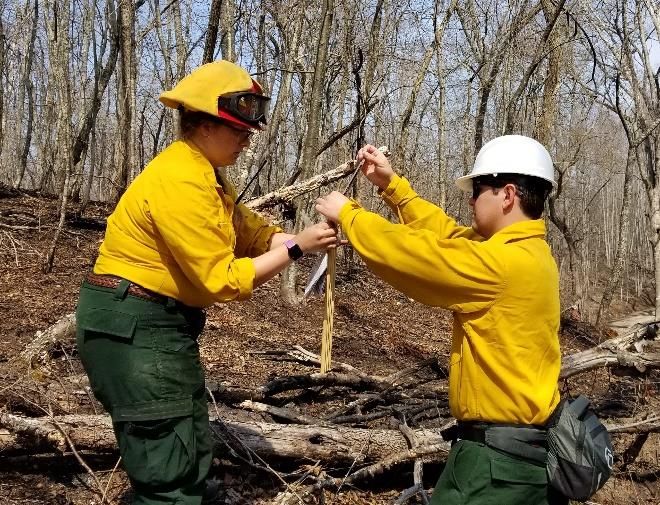
Review of the 2020-2021 Winter Season
                               Robert Anthony Beasley, Lead Forecaster

Following one of the mildest winters on               cold of any extent or duration. By the same
record in 2019-2020, meteorologists and               token, there were no anomalously warm
residents of the area alike were wondering            periods of note either.         Below zero
what the 2020-2021 winter would bring.                temperatures, which were fairly common in
Could we expect record cold temperatures              the 2014-2015 winter, failed to appear again
and snow, which we have not seen in any               this winter. Of the three meteorological
recent winters, or would it bring more warm           winter months - December, January, and
and wet conditions as we have witnessed the           February - only February proved to be a bit
past couple of winters? With El Niño in play          below average and simultaneously brought
in the El Niño-Southern Oscillation pattern,          the most snow and ice to the area.
there were certainly going to be some
                                                      Speaking of ice, it was perhaps one of the
unknowns. After all, we have to go back to
                                                      most ice-prone winters in recent memory.
2018 to find any “significant” snow storms
                                                      Several freezing rain and sleet events were
that would bring a foot or more of snow to a
                                                      noted from December through February, but
substantial portion of the forecast area during
                                                      back-to-back ice storms in mid-February
one event.
                                                      were perhaps the most notable winter
As it turns out, the winter ended up being            weather phenomena observed this past
fairly average with respect to temperature,           winter. There was significant damage to trees
but yet another in the long string of                 and power lines along the southern Blue
consecutive wet (rainy) winters with minimal          Ridge and into Southside Virginia and
snow. While nearly everyone saw more snow             adjacent areas of the Virginia and North
than what was observed the previous year,             Carolina Piedmont area. These back-to-back
snowfall for the winter remained below                ice storms in mid-February left hundreds of
average, in general. While for some it may            trees uprooted, split in half, or with numerous
have seemed like a snowy winter, in reality,          broken limbs. A ride along the Blue Ridge
snowfall was still below average for most,            Parkway from Rocky Knob to Bent Mountain
despite experiencing nearly three times the           proves this point, as even today, the sides of
amount of snowfall observed during the                the Parkway are strewn with hundreds of
2019-2020 winter. After all, three times an           downed limbs and trees. Many in these areas
inch or two is still not much snow!                   also suffered extensive power outages during
                                                      the height of the ice storms in mid-February.
With respect to temperature, there were some
notable bouts of cold, but still no extreme

SPRING 2021                           BLUE RIDGE BAROMETER                                 PAGE
                                                                                            PAGE 33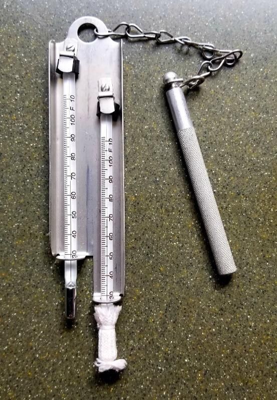
The following tables provide more detail regarding the temperature, precipitation, and snowfall
patterns of the 2020-2021 winter season. Shades of red indicate warmer than normal
temperatures, while blue equals cooler than normal. Cells shaded in green indicate wetter than
normal, while brown reflects drier than normal.
Table 1 is a comparison of 2020-2021 winter temperatures (from December-February) with 2019-
2020 temperatures and the 30-year (1980-2010) normal winter average temperature.
                   Station       2020-2021       2019-2020         Normal
                                  Winter          Winter           Winter
                                  Average         Average          Average
                                Temperature     Temperature      Temperature
               Roanoke              39.2            42.8            38.3
               Lynchburg            38.6            42.6            36.9
               Danville             39.8            43.5            39.5
               Bluefield            32.8            38.3            36.2
               Blacksburg           33.9            38.2            33.1
              Table 1

Tables 2-4 provide the average temperatures around the region in December, January, and
February 2021, as compared to those in 2020 and the average normal temperature.
                   Station        Dec 2020         Dec 2019       December
                                                                  Normals
               Roanoke               40.7            43.1           39.0
               Lynchburg             40.0            43.0           37.6
               Danville              40.9            43.5           40.1
               Bluefield             34.2            39.9           37.2
               Blacksburg            34.9            38.7           33.8
              Table 2

                   Station        Jan 2021         Jan 2020        January
                                                                   Normals
               Roanoke               38.1            41.5            36.6
               Lynchburg             37.4            41.1            35.1
               Danville              38.7            42.6            37.7
               Bluefield             31.5            37.3            34.2
               Blacksburg            32.8            37.2            31.5
              Table 3

SPRING 2021                         BLUE RIDGE BAROMETER                              PAGE
                                                                                       PAGE 4
                                                                                            4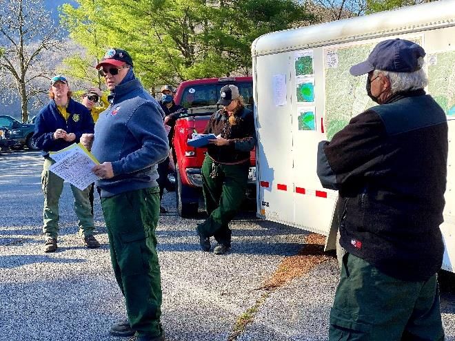
Station         Feb 2021         Feb 2020        February
                                                                    Normals
               Roanoke               38.7             43.9            39.6
               Lynchburg             38.4             43.6            38.2
               Danville              39.8             44.4            40.9
               Bluefield             32.8             37.4            37.7
               Blacksburg            33.9             38.9            34.2
              Table 4

Table 5 is a comparison of the liquid precipitation and snowfall for 2020-2021 with that of 2019-
2020, as well as what is normal for the forecast area. Note the significant increase in snowfall
this past winter (highlighted in bold).

        Station      2020-2021     2019-2020      Normal       2020-             2019-
                      Winter        Winter        Winter        2021              2020
                    Precipitation Precipitation Precipitation Snowfall          Snowfall
     Roanoke           12.19         10.18          8.75        10.3               1.6
     Lynchburg         13.40         12.20          9.31         8.9                T
     Danville          12.44         13.34          9.70         5.8               1.6
     Bluefield         11.18          9.73          8.57        44.9              11.4
     Blacksburg        11.41         11.34          8.84        23.1               4.8
     Table 5

Tables 6-8 compare the liquid precipitation and snowfall for 2020-2021 to 2019-2020 and what
is normal for the individual months of December, January, and February, respectively.

         Station       Dec 2020      Dec 2019          December        Dec      Dec
                     Precipitation Precipitation       Normals         2020     2019
                                                                     Snowfall Snowfall
      Roanoke             3.63              2.84          2.94          1.9       T
      Lynchburg           5.35              2.85          3.24           T        0
      Danville            4.44              3.19          3.27           T        0
      Bluefield           3.05              2.37          2.91         10.4      4.6
      Blacksburg          3.44              2.80          2.95          5.3      0.5
     Table 6

SPRING 2021                          BLUE RIDGE BAROMETER                               PAGE
                                                                                         PAGE 55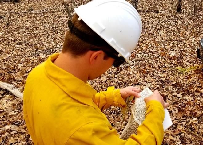
Station        Jan 2021      Jan 2020             January     Jan 2021 Jan 2020
                      Precipitation Precipitation          Normals     Snowfall Snowfall
      Roanoke             4.18          3.26                 2.92        6.6      1.6
      Lynchburg           3.81          3.98                 3.14        7.3       T
      Danville            3.57          3.82                 3.42        5.4       T
      Bluefield           3.47          2.42                 2.90        24.4     2.8
      Blacksburg          3.62          3.12                 3.08        11.2     2.5
     Table 7

         Station        Feb 2021      Feb 2020            February     Feb 2021 Feb 2020
                      Precipitation Precipitation         Normals      Snowfall Snowfall
      Roanoke             4.38          4.08                2.89         1.8       T
      Lynchburg           4.24          5.37                2.93         1.6       T
      Danville            4.43          6.33                3.01         0.4      1.6
      Bluefield           4.66          4.94                2.76         10.1     4.0
      Blacksburg          4.35          5.42                2.81         6.5      1.8
     Table 8

  Is It a Watch or a Warning? And, What’s the Difference?
                                   Stacie Hanes, Lead Meteorologist

Many people become confused as to the                 and/or strong tornadoes.        Watches are
difference between a weather warning and a            generally 20,000 to 40,000 square miles, with
watch. It may be helpful to remember that a           an average duration of six to seven hours.
watch is generally broader, longer lasting,
                                                      Watches give a heads up to the public, as well
and less specific than a warning. It is a heads
                                                      as to emergency managers, school districts,
up that severe weather may occur.
                                                      broadcast media, and storm spotters. The
A Severe Thunderstorm Watch or Tornado                public is encouraged to pay more attention to
Watch is issued by the Storm Prediction               the weather if a watch is issued and listen for
Center, located in Norman, Oklahoma. A                any subsequent warnings.           Emergency
watch is issued when conditions become                managers, broadcast media, and storm
favorable for organized severe thunderstorms          spotters use the extra time to ramp up their
and tornadoes to develop. A tornado may               operations and call in more assistance if
occur under a Severe Thunderstorm Watch,              needed.     However, it is important to
but a Tornado Watch is issued when                    remember that a watch is not a warning, and
conditions favor the development of multiple
SPRING 2021                           BLUE RIDGE BAROMETER                                 PAGE
                                                                                            PAGE 65
severe weather is not guaranteed under a              act quickly, as severe weather is already
watch.                                                underway.
A Severe Thunderstorm or Tornado Warning              For more information on thunderstorms, visit
is issued by your local National Weather              https://www.nssl.noaa.gov/education/svrwx
Service office on a case-by-case basis.               101/.
These are issued when a storm has produced,
or is expected to produce, hail one inch or
larger, damaging winds 58 mph or greater,
and/or tornadoes. Generally, these warnings
are based on clues given by radar or storm
spotter reports. A Tornado Warning is issued
if strong rotation is indicated on radar or a
tornado has been sighted. Warnings do not
account for lightning, since lightning is a
danger in any thunderstorm. Warnings are
generally issued ten to twenty minutes before
the severe weather occurs.
In short, if there is a weather watch, pay
attention to the environment around you, and
be ready to act if severe weather develops. If
you are under a Severe Thunderstorm or
Tornado Warning, it is imperative that you

New Thunderstorm Warning Format – Coming This Summer!
                           Phil Hysell, Warning Coordination Meteorologist

On June 29th, 2012, a destructive line of             Currently, Severe Thunderstorm Warnings
thunderstorms, called a Derecho, brought              do not trigger Wireless Emergency Alerts
widespread damage to our area. Despite the            (WEA) on cell phones. Beginning in mid-
fact the National Weather Service in                  July 2021, the format of Severe
Blacksburg issued Severe Thunderstorm                 Thunderstorm Warnings will change,
Warnings 25 minutes in advance, on average,           allowing for WEA alerts for particularly
many in the path of the storms were unaware           destructive severe thunderstorms that
such a destructive storm was approaching.             produce large or baseball size hail and/or 80

SPRING 2021                           BLUE RIDGE BAROMETER                                PAGE
                                                                                           PAGE78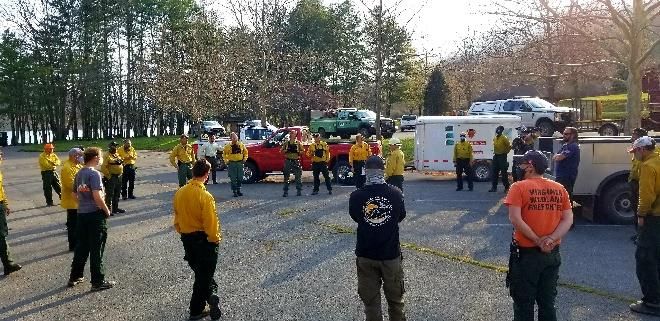
mph winds or greater, as experienced with          There are many other services that provide
the June 29th, 2012 Derecho.                       notifications for severe thunderstorm
                                                   warnings with the base or considerable
These Impact-Based Severe Thunderstorm             damage threat tags, as well as many other
Warnings focus on the expected storm               types of warnings. A list of these services can
impacts, allowing for more precise                 be found here: www.weather.gov/subscribe
communication and recommended actions.
                                                   For more information about Impacted-Based
Specifically, Damage Threat Categories will
                                                   Severe Thunderstorm Warnings, please visit:
be applied to all Severe Thunderstorm
                                                   https://www.weather.gov/media/notification/
Warnings.                                          pdf2/scn21-22svr_ibwaaa.pdf
The highest of the categories (destructive)
will be invoked if either the hail or wind
thresholds in the destructive category are met
or exceeded. WEA messages will be
activated on mobile devices whenever a
“destructive” Severe Thunderstorm Warning
is issued. For more information on WEAs,
please visit www.weather.gov/wrn/wea.

                                 Weather Witticism

“Don’t knock the weather. If it didn’t change once in a while, nine-tenths of the people couldn’t
start a conversation.” ~ Kin Hubbard
“Weather forecast for tonight: dark.” ~ George Carlin
“If you saw a heat wave, would you wave back?” ~ Steven Wright

SPRING 2021                          BLUE RIDGE BAROMETER                               PAGE
                                                                                         PAGE 89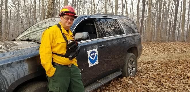
Fired Up About the Weather
                                Phillip Manuel, Incident Meteorologist

                                                      Bath County, Virginia. Prior to the burn,
                                                      crews gather to discuss the objectives and
                                                      operational plan of the burn. Weather is part
                                                      of the crew briefing.

The National Weather Service wears
different proverbial hats. In the early spring,       NWS Incident Meteorologist Phil Manuel provides a
one of the hats that gets worn most often by          weather update at the morning crew briefing prior to the
NWS Blacksburg is Fire Weather. Our                   burn.

forecasters support other federal and state           There are many weather and fuel variables
land managers in their efforts to create a            that must be considered prior to, and during a
healthier ecosystem through the use of                prescribed burn. First and foremost, is it dry
prescribed fire. We provide the fire weather          enough to burn? To answer these questions,
forecasts in order for these agencies to plan         fuel moisture measurements are made in
their burns effectively and safely.                   addition to assessing the relative humidity.
Occasionally we participate in the burns so
                                                      Fuel sticks are weighed to obtain an estimate
that we can learn how our partners use our
                                                      of how dry the fuels are prior to the burn. This
forecasts and to observe the direct impact that
                                                      is important for determining fire behavior
weather has on fire behavior and smoke.
                                                      and how well the fire will burn with respect
On Monday, April 5th, 2021, NWS                       to consumption of the smaller dead fuels. If
meteorologists Phil Manuel and Reggie                 the moisture content is too high, then you will
Roakes assisted a multi-agency team to                have poor consumption and will end up
introduce fire to the Bolar Mountain Wildlife         generating more smoke than fire.
Management Area, near Lake Moomaw in
SPRING 2021                           BLUE RIDGE BAROMETER                                        PAGE
                                                                                                   PAGE 99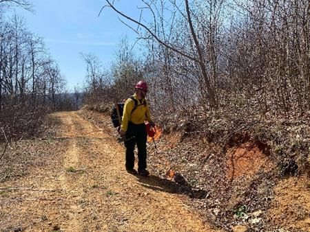
relative humidity may be calculated. Reggie
                                                             is seen here using a chart to compute the
                                                             relative humidity.

NWS meteorologist Reggie Roakes (right) is assisting
Samantha Lopez (left) from the Virginia Division of
Wildlife Resources to assess the fuel moisture by weighing
fuel sticks.

Sunny dry days are preferable for conducting
prescribed burns. The sunshine heats the
ground and dries the dead leaves and ground
litter. Fuel moisture of about 7 to 10 percent
is a desirable range for burning leaves. In
addition, a preferable range for the relative
                                                             Above is a close-up view of a sling
humidity is 25-50%. On this particular day,
                                                             psychrometer. Dry bulb is on the left. Wet
the fuel moisture was 9% and the humidity of
                                                             bulb is on the right. The wet bulb temperature
the air was around 30%, a good day to burn.
                                                             is attained by wetting the wick with distilled
                                                             water and then slinging the entire instrument
                                                             for 1-2 minutes before reading and
                                                             comparing the two temperatures.           The
                                                             temperature difference is needed in order to
                                                             compute the relative humidity.
                                                             After the fuel dryness and relative humidity
                                                             are assessed, other weather variables are
                                                             considered to determine how and when the
In the picture above, NWS Meteorologist                      firing will commence. Wind (horizontal
Reggie Roakes is taking a weather                            movement of air), stability (vertical
observation. One of the tools used in this                   movement of air), and mixing height (the
process is known as a sling psychrometer                     depth the smoke is expected to rise above
which measures dry bulb and wet bulb                         ground level) are extremely important
temperatures. From these two temperatures,                   because it helps manage the smoke, through

SPRING 2021                                    BLUE RIDGE BAROMETER                             PAGE
                                                                                                 PAGE 10
                                                                                                      10
ventilation and dispersing the smoke quickly. there is a set of achievable objectives. Fire
Consideration is also given to wind direction, can be and is a very valuable tool for many
to limit exposure to those who may be down reasons as long as it is used by individuals,
wind. agencies and organizations that know what
they are doing.
Weather plays an integral role in the firing At the end of the day (similar to the morning
operations. Temperature, humidity, wind, crew briefing), the fire personnel come back
stability, and fuel moisture have to be "just together to discuss successes and
right" before fire is put on the landscape. challenges... what was planned, what actually
happened, and what can be done next time to
make the operation better. This is called an
After Action Review (AAR) and is done in
an effort to learn from everyone that
participated in the burn... including the
meteorologist.
Why burn? Fire is natural and plays a very
important role in creating a healthy
ecosystem by eliminating invasive species.
In addition to ecosystem improvement,
prescribed burns keep the public and homes
safe by reducing the buildup of dried leaves
and dead wood that can lead to uncontrolled
Did you know? The National Weather
wildfires.
Service has a cadre of Incident
Bolar Mountain is an example of “good fire,” Meteorologists (IMETs) that provide weather
managing fire when the weather conditions support nationally and internationally. The
support the practice of controlled burning and mission of the National Weather Service is
SPRING 2021 BLUE RIDGE BAROMETER PAGE 11
PAGE 10the protection of life and property, and this
includes sending our folks directly to the
front lines with boots on the ground to assist
teams of wildland fire fighters during
destructive wildfires.
For more information on the IMET program,
follow us on Facebook:
https://www.facebook.com/US.NationalWea
therService.IMET.gov/
For information on local Fire Weather
Forecasts: https://www.weather.gov/rnk/fire
Staying Safe While Enjoying the Great Outdoors
Stacie Hanes, Lead Meteorologist
Summer is the perfect time to enjoy the many take shelter near trees. If there is no safe
outdoor activities that our area is known for, building or vehicle nearby, avoid open fields
such as boating, hiking, or biking. But and the tops of ridges, and stay away from
whether you plan to kayak around Smith water.
Mountain Lake or hike the Appalachian
Once in a safe building or vehicle, stay put
Trail, there are certain guidelines you should
for at least 30 minutes after you hear the last
remember regarding the weather.
clap of thunder. A lightning flash can travel
Thunderstorms occur frequently and can over 10 miles from the parent thunderstorm,
develop rapidly during the summer months, so it is important to keep abreast of changing
quickly turning a trip to the beach into a scary weather situations. If a thunderstorm poses a
ordeal. In particular, lightning poses a great tornado, damaging wind, or large hail threat,
risk to those enjoying outdoor activities. You a Severe Thunderstorm Warning or Tornado
can substantially reduce your risk of getting Warning will be issued by your local NWS
struck by lightning if you are caught outside office. A great way to stay up to date on life-
in a storm by quickly finding shelter in a saving warnings and weather information is
building or a car. The safest buildings to invest in a portable NOAA Weather Radio.
include completely enclosed rooms. Car These are very helpful for getting weather
ports, covered patios, and tents are the least
safe. If you are caught out in the open, do not
SPRING 2021 BLUE RIDGE BAROMETER PAGE 12
PAGE 10information in remote locations where cell transitions at the National Weather Service in
phone service may not be available. Blacksburg. Here are some highlights:
Flash flooding often accompanies Jeffrey Moss
thunderstorms, and can strand campers or
even wash away cars. Even a small amount Jeffrey is neither a new employee nor on his
of rain may cause creeks and streams to rise way out, but he was recently promoted from
suddenly. Your best protection is being Electronics Technician, a position he had
aware of the threats and always knowing held since joining our team in the summer of
where to find higher ground. Again, having 2018, to Information Technology Specialist
a way to receive warnings when out of cell in January of this year, filling a nearly year-
phone range may save your life. long vacancy in that position. Jeffrey has
always had a strong interest in problem-
Other favorite summer pastimes in the
solving, IT system management, and
Virginias and North Carolina include boating
coding/scripting, and is quickly sharpening
and kayaking. Studies have shown that the
those skills in his new role. Whether he is in
vast majority of injuries and deaths due to
the building or in a video meeting, he can
lightning occur near water. This is because
often be heard laughing, and he always
water is an excellent conductor of electricity.
brightens the mood of those around him.
If thunderstorms are in the forecast, postpone
the trip for another day. If you are out on the Nick Fillo
water and skies become threatening, get back
to shore as soon as possible. Like Jeffrey, Nick is neither coming nor
going. He has actually been in this office for
Enjoy the great outdoors this summer, but quite a few years now - first as a forecaster
always remember to check the forecast and and then as our Observational Program
take your NOAA Weather Radio along on Leader. He will be starting in his new role
any outings. You can find weather forecast (also a promotion) as our Senior Service
information for several points of interest at Hydrologist in May. He has been serving in
https://www.weather.gov/rnk/recreation. that role for about eight months already,
while at the same time performing his other
What’s New In Our Office: duties and working the forecast desk as
needed. He had also been assisting our
Personnel Changes previous Hydrologist, Peter Corrigan, in a
variety of ways for several years before
Steve Keighton, AMIC
Peter’s retirement late last summer. So, Nick
Spring is certainly a time of weather is hitting the ground running (or diving into
transitions, but this first half of the year we the water, already swimming?) in his new
are also undergoing our share of staffing position, knowing the hydrology of the
SPRING 2021 BLUE RIDGE BAROMETER PAGE
PAGE13
10region and our partners very well to begin trails in this area during his spare time. Doug
with. Given his previous role, Nick certainly is looking forward to getting out and meeting
understands the importance of quality data as many of our partners as soon as it is safe to
and its role in helping produce the most do so again, and we are looking forward to
accurate river forecasts possible. We are having a new supervisor to lead our team here
excited for what he will bring to the office in at NWS Blacksburg.
his new position.
Mike Sporer
Doug Butts
Finally, we will be bidding a bittersweet
farewell to Meteorologist Mike Sporer, who
accepted a promotion to Lead Forecaster at
the NWS in North Platte, Nebraska! Mike,
and his wife Cathy, will be heading out to the
northern Plains in early June. Mike has been
instrumental in helping our office find new
and more efficient ways of doing business,
but he has also been one of the leaders in
moving the agency forward with drone
We are also excited to announce the expected technology to supplement ground-based
arrival of a new Meteorologist-in-Charge by storm damage surveys, as well as surveying
the end of May - Mr. Doug Butts! Doug instrument locations to track changes in
replaces Dave Wert, who retired at the surroundings. He has involved Virginia Tech
beginning of 2020, and comes to Blacksburg student volunteers in some of his projects as
from the NWS in Binghamton, New York well, and has done a great job mentoring
where he has been in that same position for many of our newer meteorologists here. We
three and a half years. Doug was previously will miss Mike’s experience, strong
the Science and Operations Officer in meteorology skills, and can-do attitude! We
Mobile, Alabama (his home state), and also know Mike will bring these same attributes to
spent time at the NWS offices in his new office in Nebraska. Congratulations,
Brownsville, Texas, Shreveport, Louisiana, and best of luck Mike!
and Jackson, Mississippi, after beginning his
NWS career in the Mobile, Alabama office.
He brings a wealth of experience from many
different weather regimes and offices, and he
is happy to be getting back down south again!
Doug is married with three children, and will
likely be out on the many biking and running
SPRING 2021 BLUE RIDGE BAROMETER PAGE
PAGE 14
10from a thunderstorm to your eye is practically
Kidz Korner zero seconds.
Welcome to the spring edition of Kidz When lightning occurs, it heats up the air
Korner! Our topic today is: around it to a temperature greater than that of
the sun. This happens very rapidly and causes
an explosion of the air. The result is the sound
of thunder. While the speed of sound is fast,
it is not even close to the speed of the light
that the lightning generates. If you are
located one mile from a thunderstorm, you
will have to wait five seconds for the sound
of thunder to reach you after you see a flash
of lightning.
Spring and summer bring green grass and
trees, homegrown flowers, fruits, and With this information, you are able to act as
vegetables, warm days and the smell of your own kind of weather radar! When you
sunscreen, and the occasional thunderstorm. see your first flash of lightning from a storm,
Earlier in this edition, you may have read the start counting your Mississippi’s -- “One-
article our meteorologist, Stacie Hanes, wrote Mississippi, two-Mississippi, three-
about weather safety. All of her information Mississippi,” and so on -- until you hear
is very important, and something you and thunder. If it took 15 Mississippi’s between
your family should keep in mind during and when you saw the lightning and when you
before a thunderstorm. heard the thunder, the storm is three miles
from you.
The National Weather Service radar allows
meteorologists to see where thunderstorms (CAUTION MATH AHEAD: 15 seconds
are across the region, which way they are divided by 5 seconds for every mile equals 3
moving, and how far away they are from a miles.) As the storm moves through your
particular location. It is a pretty nifty piece area, the time it takes for you to hear the
of equipment! thunder will either increase or decrease. If it
increases, that means the storm is getting
Guess what! By seeing lightning and hearing
farther away from you. If the time decreases,
thunder, you too can determine just how far
that means the storm is getting closer to you.
away a thunderstorm is from your location.
The light from a flash of lightning travels Keep in mind this method works best when
amazingly fast. Its speed would take it from there is only one thunderstorm for you to
the earth to the moon in just one second! In track. If there is more than one storm, it
contrast, the short distance light must travel becomes almost impossible to tell which
storm produced the thunder you are hearing.
SPRING 2021 BLUE RIDGE BAROMETER PAGE
PAGE 15
10Take the Time To submit your original drawing, poem, or
story, scan your artwork or writing into a .jpg
My day is so busy, with homework and
computer image file (with the help of an
chores,
adult, if needed). You can also write your
But I always like to dance in the rain poem or story using Word and save it as a
When it pours. .doc or .docx file. Please keep any written
material to 500 words or less. Artwork may
The flowers are growing, and dandelions too. also be completed using drawing or painting
I enjoy picking them for my mom software, submitted as a .jpg file.
When she’s blue. When submitting your drawing, poem, or
story, please include your first name and first
The thunder grows louder, the showers begin. initial of your last name, age, and the
I look out my window and wave at you, city/town where you live. All entries should
be submitted no later than October 1, 2021.
“Please, come in!” Please email your entries here.
When the storms roll away, all will be fine. We look forward to hearing from you!
Let’s watch nature at work -
Take the time.
~ Author Unknown
Feeling creative? Would you like to see your
art or writings included in the next edition of
Blue Ridge Barometer? If you are between
the ages of 3 and 17, we would love to see
your hand-drawn artwork, short poems, or
short stories about the weather. For the next
edition, we are looking for art and writings
that involve the fall or winter. Our
meteorologists will review the submissions
and select a few to include in the newsletter.
Maybe yours will be one of them!
SPRING 2021 BLUE RIDGE BAROMETER PAGE
PAGE 16
10From Piedmont to Mountaintop
In this edition, we share with you a few pictures that were taken by our meteorologists. The first
one was captured right before sunrise on a December morning. Scattering of sunlight by the
atmosphere during the day produces the familiar blue color. When the sun is still below the visible
horizon, the red and orange side of the spectrum (remember Roy G. Biv?) is scattered and
intersects the bottoms of the clouds, which in turn is reflected to our eyes and generates this fiery
sky image. The same effect can also happen at sunset.
Our second picture captures the arrival of a snow squall. Much like a line of showers or storms
in the spring, the snow squall line has a relatively narrow width, and crosses an area rapidly with
a sudden burst of precipitation. Notice how the landscape in the background on the left side of
the picture is completely obscured by the snow? In contrast, in the background on the right side,
we can still see clear sky, and even the foreground is still snow-free. This type of event can reduce
visibilities to near zero and make travel extremely hazardous very quickly.
SPRING 2021 BLUE RIDGE BAROMETER PAGE
PAGE 17
10Our final picture is a combination of flora and fauna. Here, we can see four deer searching for
food among the bare patches of melted snow cover.
SPRING 2021 BLUE RIDGE BAROMETER PAGE 10
18While we at the National Weather Service enjoy taking weather-related pictures, we would love
to see snapshots of the weather in your neighborhood! From now through October 1, 2021, we
invite you to take some weather-related photos and share them with us. Please include with your
photos your first name, the first initial of your last name, and where and when you took the picture.
We will select a few photos from the total number submitted by the public for inclusion in
upcoming newsletters and credit them appropriately. Also, by submitting a picture, you agree
that we can use it on one of our social media platforms (Facebook and Twitter) or in our local
community outreach presentations (for example, a SKYWARN class). Photos used in these
forums would also be credited appropriately. We look forward to seeing our region through your
lens!
Stay Safe & Stay Involved!
The spring and summer seasons not only bring warmer temperatures, but a wide range of potential
weather hazards, including flooding, lightning, and even tornadoes. Check out the NWS Weather
Safety page for information on all types of weather hazards. If you are interested in helping the
NWS with storm spotting and verification, please consider participating in the SKYWARN
program. Additionally, the NWS can always use new rain/snow observers for the CoCoRaHS
network, especially in West Virginia!
To keep up to date on what’s happening in our office in between newsletters, please visit our
website: https://www.weather.gov/rnk or follow us on Twitter and Facebook.
For questions or comments about this newsletter, please contact the editor or via snail mail at:
Blue Ridge Barometer
National Weather Service
1750 Forecast Dr
Blacksburg, VA 24060
SPRING 2021 BLUE RIDGE BAROMETER PAGE
PAGE 19
10You can also read