Operational space weather service for GNSS precise positioning
←
→
Page content transcription
If your browser does not render page correctly, please read the page content below
Annales Geophysicae, 23, 3071–3079, 2005
SRef-ID: 1432-0576/ag/2005-23-3071                                                                                  Annales
© European Geosciences Union 2005                                                                               Geophysicae

Operational space weather service for GNSS precise positioning
N. Jakowski, S. M. Stankov, and D. Klaehn
German Aerospace Centre (DLR), Institute of Communications and Navigation, Kalkhorstweg 53, 17235 Neustrelitz,
Germany
Received: 22 February 2005 – Revised: 18 June 2005 – Accepted: 20 July 2005 – Published: 22 November 2005

Part of Special Issue “1st European Space Weather Week (ESWW)”

Abstract. The ionospheric plasma can significantly influ-        weather – induced adverse effects on the Earth’s ionosphere-
ence the propagation of radio waves and the ionospheric dis-     plasmasphere system (Jakowski et al., 1998, 1999, 2002a,
turbances are capable of causing range errors, rapid phase       2002b, 2003a, 2004b; Langley, 2000; Makela et al., 2001;
and amplitude fluctuations (radio scintillations) of satellite   Stankov, 2002; Skone and Shrestha, 2002). Such effects can
signals that may lead to degradation of the system perfor-       ultimately cause various types of problems including: range
mance, its accuracy and reliability. The cause of such dis-      errors, rapid phase and amplitude fluctuations (radio scintil-
turbances should be sought in the processes originating in       lations) of satellite signals, etc., that may lead to pronounced
the Sun. Numerous studies on these phenomena have been           signal degradation, degradation in the system performance,
already carried out at a broad international level, in order     its accuracy and reliability (Moulsley and Vilar, 1982). Also
to measure/estimate these space weather induced effects, to      reported are strong voltage fluctuations and harmonic fre-
forecast them, and to understand and mitigate their impact on    quencies in the electricity, electrical power line shutdowns
present-day technological systems.                               and blackouts (Harang, 1941; Kappenman, 1996; Boteler
   SWIPPA (Space Weather Impact on Precise Positioning           and Jansen Van Beek, 1999). Being electrical conductors,
Applications) is a pilot project jointly supported by the        oil and gas pipelines are also vulnerable to strong geomag-
German Aerospace Centre (DLR) and the European Space             netic disturbances (Pirjola et al., 1999); geomagnetically in-
Agency (ESA). The project aims at establishing, operat-          duced currents (GICs) produce additional voltages between
ing, and evaluating a specific space-weather monitoring ser-     the pipeline and the ground which can easily exceed the pro-
vice that can possibly lead to improving current positioning     tective voltage, therefore damaging the corrosion protection.
applications based on Global Navigation Satellite Systems        In addition, GICs also may hamper rail traffic by disturb-
(GNSS). This space weather service provides GNSS users           ing some types of signalling systems. Aviation and space
with essential expert information delivered in the form of       flights are particularly at risk due to increased radiation and
several products – maps of TEC values, TEC spatial and tem-      possible navigation/telecommunication problems (Oksanen,
poral gradients, alerts for ongoing/oncoming ionosphere dis-     1998; Koskinen et al., 1999). Apart from the increased risk
turbances, etc.                                                  of using the affected systems, the negative impact of ad-
                                                                 verse space weather can also have a purely economic dimen-
Keywords. Ionosphere (Ionospheric disturbances; Model-
                                                                 sion. With the future advancement of technology, the above-
ing and forecasting; Instruments and techniques)
                                                                 mentioned risks and possible financial losses will certainly
                                                                 increase unless suitable protective measures are taken in ad-
                                                                 vance.
1 Introduction
                                                                    Since trans-ionospheric propagation effects are responsi-
                                                                 ble for positioning errors in satellite-based navigation and
The Space Weather is defined as the set of all conditions – on
                                                                 positioning, the GNSS users need to apply appropriate mit-
the Sun, and in the solar wind, magnetosphere, ionosphere
                                                                 igation techniques, such as corrections by the use of: dual
and thermosphere – that can influence the performance and
                                                                 frequency techniques, model corrections, local or global
reliability of space-borne and ground-based technological
                                                                 augmentation systems. Strong gradients in the horizontal
systems and can endanger human life. Several studies have
                                                                 TEC structure and small-scale structures of the ionospheric
already been performed showing clear evidences of space
                                                                 plasma may seriously complicate or even prevent the resolu-
Correspondence to: S. M. Stankov                                 tion of phase ambiguities in precise geodetic and surveying
(stanimir.stankov@dlr.de)                                        networks. Principally, in reference networks, the ionospheric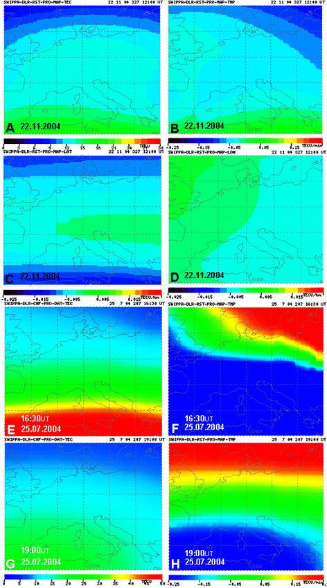
3072                                           N. Jakowski et al.: Operational space-weather service for GNSS precise positioning

                                                                       2     Space weather effects observed on GNSS applications

                                                                       There are several problems currently experienced by GNSS
                                                                       users which can be related to space weather effects.

                                                                       2.1    Increased time required to fix GNSS signal phase am-
                                                                              biguities

                                                                       GNSS reference networks provide ionospheric corrections to
                                                                       the users in order to help them achieve centimetre level accu-
                                                                       racy. A very important factor determining the performance
                                                                       of such a GNSS reference network service is the time re-
                                                                       quired to solve the phase ambiguities. The strong variabil-
                                                                       ity of the ionosphere obviously affects the determination of
                                                                       phase ambiguities. Presented here is a case when such diffi-
                                                                       culties arise, and at a certain stage it becomes even impos-
                                                                       sible to fix the ambiguities. A typical example of such a
                                                                       problem occurred on the geomagnetically disturbed day of
                                                                       29 October 2003 at 12:32 UT: the ambiguity fixing time ex-
                                                                       tended so much that it became impossible to achieve a fixed
                                                                       solution (Fig. 1A). During such periods it is very difficult to
                                                                       model the error influences and therefore the user cannot ob-
                                                                       tain precise positioning. However, nowcast and/or forecast
Fig. 1. A: Time required to fix ambiguities: a case during the iono-
                                                                       of the ionospheric disturbances can certainly help the GNSS
spheric storm on 29 October 2003. Notice the increased fixing time
                                                                       users, at least to be aware of such disturbances and to recog-
(more than 3 min) at 12:24 UT and the breakdown at 12:32 UT. B:
Storm effects demonstrated on the number of tracked, processed,        nize that a problem is (to be) expected.
and solved satellites. Normally, the number of processed satellites
should be equal to the number of solved satellites.                    2.2    Discrepancies between “processed” and “solved”
                                                                              GNSS satellites

corrections degrade when the spatial de-correlation of propa-          Specialised positioning algorithms are used for “solving” the
gation terms increases, particularly in the course of severe           phase ambiguities. In order to maintain a regular and reli-
ionospheric storms. Whereas medium-scale variations in                 able service, it is necessary to ensure that, at any given mo-
time and space, such as Traveling Ionospheric Disturbances             ment in time, the signal phase ambiguities are “solved” for at
(TIDs), mainly impact reference networks, local, small-scale           least 5 GNSS satellites. To ensure this minimum number of
irregularities may cause radio scintillations, inducing severe         “solved” satellites, each particular ground receiving station
signal degradation and even loss of lock. Amplitude scin-              tracks as many GPS and GLONASS satellites as possible.
tillations and phase fluctuations are caused by refractive and         Some of these “tracked” satellites cannot be used due to re-
diffractive scatter by ionospheric plasma-density irregulari-          strictions imposed on the satellite elevation angle (elevation
ties, especially at equatorial and auroral-to-polar latitudes.         cutoff criterium), the signal-to-noise ratio (SNR criterion),
    SWIPPA (Space Weather Impact on Precise Positioning                etc. The remaining satellites are being “processed”, i.e. their
Applications) is a project aiming at establishing, operating,          signals are used in the processing software for fixing the am-
and evaluating a specific space-weather monitoring service             biguities. Criteria also exist when trying to solve the ambigu-
that can possibly lead to improving current positioning ap-            ities, for example, the errors should be small and the solution
plications based on GNSS (Jakowski et al., 2002c, 2003b,               stable. Therefore, due to the “solving criteria” some of the
2004a). The SWIPPA service centre operates a powerful                  “processed” satellites cannot be used. Thus, the satellites for
data processing system which, working in both real-time                which the ambiguities have been fixed (solved), are called
and post-processing modes, provides the project consortium             “solved” satellites and their number is equal to or less than
members with essential expert information delivered in the             the number of processed satellites. Under normal conditions,
form of several products – maps of TEC values, TEC spatial             the number of “processed” satellites should equal the number
and temporal gradients, alerts for ongoing/oncoming iono-              of “solved” satellites. This is exactly the situation between
sphere disturbances, etc.                                              00:00 UT and 06:00 UT on 29 October 2003 when the num-
    Presented in this paper are several case studies of prob-          bers were sometimes between 11 and 6 satellites (Fig 1B).
lems arising from the space weather impact on GNSS-based               Obvious discrepancies between processed and solved satel-
applications and the SWIPPA operational service which can              lites started to occur shortly after the first geomagnetic storm
be used to help the GNSS users to mitigate the above men-              started at 06:00UT. The situation has gradually worsened
tioned problems.                                                       as the storm developed and the solved/processed percentage
N. Jakowski et al.: Operational space-weather service for GNSS precise positioning 3073
ratio dropped to only 20–30%. Moreover, the number of
solved satellites fell even below the critical level, mean-
ing that the positioning was no longer reliable. The worst
happened at around 14:00 UT when the number of solved
satellites dropped to the zero level and the service effec-
tively stopped. Such extreme situations are rare, but should
they occur, they could seriously disturb GNSS-based appli-
cations. As the storm entered the recovery phase (at around
15:00 UT), the situation slightly improved - the number of
solved satellites increased above the threshold level. How-
ever, the discrepancies were still large and the danger of go-
ing back to unreliability was present until 22:00 UT on 29
October 2003.
2.3 Phase and amplitude fluctuations
Phase and amplitude fluctuations are caused by the refractive
and diffractive scattering due to ionospheric plasma irregu-
larities, especially at equatorial and polar latitudes (Beniguel,
2002; Beniguel et al., 2004). The problem with such small-
scale irregularities is that they can lead to cycle slips and
tracking losses (scintillations). Medium-scale irregularities
(TIDs) and strong ionospheric gradients may cause different
signals at the reference station and the user site, i.e. the cor- Fig. 2. A: Phase fluctuations observed during the 6–7 April 2000
rection message transmitted from the GNSS reference net- storm. B: Network Model Integrity monitoring. Increased errors
work centre to the user in the field will be definitely wrong. observed from 19:00 UT to 20:00 UT on 26 November 2004 in the
The strong TEC dynamics at high latitudes, observed during northwest German reference sub-network.
the storm on 6 April 2000, were of the order of 40×1016 m−2
(≈6.50 m on the GPS L1 frequency) which caused difficul-
and increased inaccuracies. An NMI plot (Fig. 2B) shows
ties for the precise positioning and navigation (Jakowski et
the averaged error over an entire reference network (or if the
al., 2002b). During this event, rapid phase fluctuations have
network is too large – over a sub-network), i.e. the average of
been detected by both the GPS and GLONASS receivers in
the errors at the network stations. The horizontal axis shows
mid-latitude Europe (Fig. 2A).
the hour of the day (universal time), while the vertical axis
shows the error. Recent experiences teach that it is hardly
2.4 Decreased reference network model integrity
possible to obtain precise and accurate results while the er-
ror is larger than 8 cm. If the error is between 4 and 8 cm,
The Network Model Integrity (NMI) is an important opera-
the reference network user has to accept longer times to fix
tional parameter used in the GNSS reference network soft-
ambiguities. Smaller values represent a quiet ionosphere.
ware to control both the integrity and the quality of the satel-
lite positioning services. In fact, the NMI module is used to
describe the potential non linear residual errors in the gen- 3 Case studies
erated data transmitted to the user. The non linear error is
estimated in the following manner. Initially, the ionospheric Reported here are adverse space weather effects on precise
influence on GNSS signals is determined and then the linear positioning, observed during two recent strong ionospheric
parts of these effects are removed by applying ionospheric storms, on 29 October 2003 and on 25 July 2004. The anal-
and geometric corrections to the raw data. The influence ysis is focused on the ionosphere perturbations’ impact on
on the user position is interpolated from the influence deter- positioning – the increased time required to fix GNSS sig-
mined on the surrounding reference stations. During periods nal phase ambiguities; discrepancies between the numbers
of disturbed ionosphere, however, the ionospheric residuals of tracked, processed and solved GNSS satellites; strong
cannot be considered linear, even locally. The nonlinear er- phase and amplitude fluctuations, etc. Also detailed are the
ror is determined by omitting one station from the interpo- observations of the geophysical conditions during these two
lation, comparing the interpolation results for all satellites at storms and the means to mitigate the adverse effects. On
that station with the real measurements, then computing the 29 October 2003, strong large-scale ionospheric perturba-
weighted RMS over all satellites at one epoch, and accumu- tions that can potentially lead to performance degradation of
lating these weighted RMS over one hour to obtain a 95% reference networks were first detected in the northern polar
distribution. As mentioned, if the residual error is large, the region (Fig. 3). When the solar wind energy, measured by
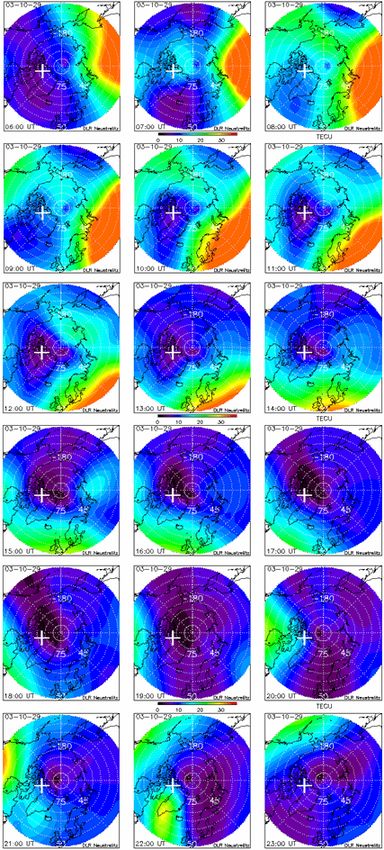
user may experience longer times for fixing the ambiguities the Northern Hemispheric power index (Foster et al., 1986),3074 N. Jakowski et al.: Operational space-weather service for GNSS precise positioning Fig. 3. Ground-based GPS TEC observations over the North Pole region in the 06:00 UT–23:00 UT period on 29 October 2003.
N. Jakowski et al.: Operational space-weather service for GNSS precise positioning                                             3075

couples with the magnetosphere, strong convection elec-
tric fields are generated that may be accompanied by direct
particle precipitation producing additional ionization in the
bottom-side ionosphere. The action of such a strong con-
vection electric field is visible in the polar TEC maps from
07:00–12:00 UT when a significant horizontal plasma trans-
port from the dayside towards the nightside ionosphere took
place, probably via the electromagnetic E×B drift. A sec-
ond event of enhanced perturbation activity is seen in the po-
lar TEC maps around 21:00 and 22:00 UT; however, the in-
duced perturbations are more significant over the South Pole
(Stankov and Jakowski, 2004). These and other observa-
tions clearly indicate that the polar ionosphere is a kind of
“space weather kitchen”, where perturbation processes are
generated and then propagate towards lower latitudes (Fo-
erster and Jakowski, 2000; Jakowski et al., 2003a). Un-
fortunately, not much is known so far about such propa-
gation processes. A careful analysis of these observations
will contribute to improving our understanding of large-scale
                                                                  Fig. 4. Adverse space weather effects on the operational quality of
perturbation processes and their propagation towards lower        reference networks. The network model integrity on 25 July 2004
latitudes (Stankov et al., 2005). Thus, the permanent ob-         for the NW, MW, SW, ME, SE areas of Germany (cf. the TEC map
servations also offer the unique chance of developing tech-       in the upper right corner).
niques/procedures that can be applied for predicting severe
ionospheric perturbations expected to occur even at middle
latitudes with a certain time delay (Stankov et al., 2001).
                                                                  are offered to the consortium members, designated users,
   The last 10 days of July 2004 were remarkably active con-
                                                                  and the general public. These products, based on the infor-
sidering the approaching minimum in the current solar ac-
                                                                  mation of the actual and predicted state of the ionosphere-
tivity cycle. Three consecutive major storm events occurred,
                                                                  plasmasphere system, provide only the type of space weather
with the Dst index reaching −104 nT on 23 July, −150 nT
                                                                  information which GNSS users really need for the execution
on 25 July and −167 nT on 27 July. The IMF and geomag-
                                                                  of their day-to-day tasks.
netic fields were seriously disturbed. Again, several prob-
lems were reported by GNSS users but here we will take
a closer look at the reference network model integrity only.      4.1   Processing system
Presented here are the results of the network model integrity
tool for 25 July 2004 (Fig. 4). The plots of the different sub-   The SWIPPA service centre operates a powerful data pro-
nets are shown according to the area they cover in Germany        cessing system (Fig. 5), working in both real-time and post-
(NW – North West, NE – North East, MW – Mid West, ME              processing modes, to provide the customers with actual in-
– Mid East, SW – South West, SE – South East). Around             formation and to feed the forecasting module with the newest
noon, higher-than-usual values were seen in the eastern ar-       information available from our partners, from the Space
eas. Later, the influence was detected in the western areas, as   Weather European Network (SWENET) community, and
well.                                                             from external sources, like world data centres. The SWIPPA
                                                                  data processing system generates near real-time products
                                                                  based on data from the ascos (http://ascos.ruhrgas.de/) and
4 Operational service for precise positioning applica-            the SAPOS (http://www.sapos.de/) reference networks. Typ-
  tions of GNSS                                                   ically, these networks are operated at monitoring stations,
                                                                  with a sampling rate of 1 measurement per second (1 Hz
First motivated by several problems experienced by GNSS           sampling rate). Depending on the data source, the data is
users, then by analysing these problems and considering the       formatted and transferred to the SWIPPA processing facil-
research and operational monitoring experience, the DLR           ity at DLR, using the in-house data format and data transfer
team initiated a project SWIPPA (Space Weather Impact             protocols. According to the types of products being gener-
on Precise Positioning Applications), aiming at establishing      ated, several processing chains had to be designed and imple-
and operating a specific space-weather monitoring service         mented. Because of the experimental nature of the project,
for improving current Global Navigation Satellite System          aimed at demonstrating the potential of the space weather in-
(GNSS) applications (http://www.kn.nz.dlr.de/swippa/index.        formation as derived from ionospheric monitoring systems,
htm). Within this project, real-time data products and ser-       we have taken advantage of some pre-existing DLR soft-
vices (TEC maps, TEC spatial and temporal gradients maps,         ware components and universal processing structures that
cycle slips number, geophysical conditions warnings, etc.)        have been applied by DLR in several projects before.
3076 N. Jakowski et al.: Operational space-weather service for GNSS precise positioning
grow to be much larger than the noise and multipath effects
that the filter is supposed to reduce. Ionospheric gradients
are reportedly capable of inducing biases as large as 20–30 m
(Walter et al., 2004). The production of TEC gradients maps
is based on the calculation of temporal and spatial gradient
at each grid point in the European region (optimally, 1 deg
spatial resolution). Three types of gradient maps are created
– temporal (time) gradients (Fig. 6B), latitudinal gradients
(Fig. 6C), and longitudinal gradients (Fig. 6D).
4.2.3 Geophysical/space weather condition warning
After analyzing and synthesizing the incoming geophysical
information, short messages are forwarded to users, warn-
ing them about on-going ionosphere disturbances. The geo-
Fig. 5. A schematic view of the SWIPPA operational system. physical warning (Fig. 7) is based mostly on the geomag-
netic index Kp estimations/predictions using solar wind ob-
servations (wind density, speed) on board the satellite ACE
4.2 Products and services (Advanced Composition Explorer). A neural network algo-
rithm (Costello, 1997), trained on the response of Kp to solar
Following the SWIPPA consortium user requirements, sev- wind parameters, uses most recent solar wind measurements
eral products were developed and expert services established. to predict Kp . Additional real-time data, such as the geo-
magnetic field’s horizontal component (Niemegk: 12.7◦ E,
4.2.1 TEC mapping 52.1◦ N) and the percentage deviation of the ionospheric
critical frequency (foF2) from monthly medians (Juliusruh:
The GPS data allow for the determination of slant TEC val-
13.4◦ E, 54.6◦ N), are also considered but as validation tools
ues along numerous satellite-receiver links over the Euro- rather than values on which to base the warning. The warn-
pean area. The instrumental biases are separated from the ob-
ing message is kept simple, so it can be conveniently used by
servations by assuming a second-order polynomial approxi- programmers via the ftp protocol.
mation for TEC variations over the observing GPS ground
station. Both the TEC and the instrumental satellite-receiver 4.3 Exemplary results
biases are estimated simultaneously by a Kalman filter run
over 24 h. Thus calibrated, the slant TEC data are mapped to As an example, demonstrated here is how SWIPPA products
the vertical by applying a mapping function which is based and services can really help. By generating high-resolution
on a single layer approximation at height of 400 km. Finally, maps of the TEC spatial and temporal gradients, the sharp in-
the observed TEC data are combined with a regional TEC crease in TEC in the northeast region during the 25 July 2004
model, the Neustrelitz TEC Model (NTCM), in a way that the storm becomes quite obvious (Figs. 6E and F) and its prop-
resulting map (Fig. 6A) provides measured values at some lo- agation in the southward and westward direction can eas-
cations and model values at regions without measurements. ily be traced (Figs. 6G and H). As the front of the detected
The advantage of such an assimilation technique is that even disturbances moves through Europe, it causes various prob-
in the case of a low number of measurements, it delivers rea- lems, including the decrease in the network model integrity
sonable ionospheric corrections which can be provided to the (Fig. 4). What is important to mention here is that, in this
users to help them enhance accuracy and integrity of posi- case, probably due to the exhaustion of the ionosphere during
tioning (Jakowski, 1996; Jakowski et al., 1996). the persisting storm conditions from the previous days, large-
scale TEC maps of the Polar and European regions may not
4.2.2 TEC gradients mapping provide clear and early indications for the developing storm
conditions at lower latitudes. Such clear and advanced indi-
The observance of strong ionospheric gradients indicates
cations have been successfully delivered by the new, direct,
the development of highly dynamic processes in the Earth’s
high-resolution, and frequent mapping of the TEC values and
ionosphere-plasmasphere system, with the potential of hav-
TEC spatial/temporal gradients.
ing degrading effects on positioning/navigation. For exam-
ple, both WAAS (Wide Area Augmentation System) and
LAAS (Local Area Augmentation System) receivers utilize 5 Summary and outlook
carrier-smoothing filters to reduce the effects of multipath
and thermal noise at the aircraft. By applying such fil- Several cases were presented of adverse space-weather ef-
ters, users can ultimately improve accuracy. However, the fects on precise positioning, observed during the ionospheric
presence of significant ionospheric gradients can introduce storms on 29 October 2003 and 25 July 2004. The focus
a bias into this filter’s output; if unmitigated, this bias can was on the increased fixing time, the discrepancies betweenN. Jakowski et al.: Operational space-weather service for GNSS precise positioning 3077 Fig. 6. SWIPPA products and services for the European area. Exemplary maps of the TEC (A), TEC temporal (B), latitudinal (C), and longitudinal (D) gradients at 12:00 UT on 22 November 2004. Maps of the TEC (E, G) and TEC temporal gradients (F, H) on 25 July 2004.
3078                                           N. Jakowski et al.: Operational space-weather service for GNSS precise positioning

                                                                          The operational space-weather service is currently being
                                                                       independently assessed and recommendations for further im-
                                                                       provements are expected. However, in line with the increased
                                                                       sophistication of present-day technological systems, it is al-
                                                                       ready clear that there will be a growing market for naviga-
                                                                       tional and precise positioning applications in Europe, partic-
                                                                       ularly when GALILEO becomes operational.

                                                                       Acknowledgements. The SWIPPA project has been jointly sup-
                                                                       ported by the German Aerospace Centre (DLR) and the European
                                                                       Space Agency (ESA) under contract ESTEC 16952/02/NL/LvH.
                                                                       The work was carried out within the framework of the ESA space
                                                                       weather applications pilot project and is part of the SWENET net-
                                                                       work.
                                                                       The authors thank Allsat network+services GmbH, E.ON
                                                                       Ruhrgas AG, International GPS Service (IGS), NOAA Space En-
                                                                       vironment Center (SEC), German Federal Agency for Cartography
                                                                       and Geodesy (BKG), GeoForschungsZentrum Potsdam (GFZ),
                                                                       Adolf-Schmidt Geomagnetic Observatory Niemegk, Institute of
                                                                       Atmospheric Physics Kühlungsborn, and Tromsø Geophysical
                                                                       Observatory for kindly providing data needed for the SWIPPA
                                                                       project.
                                                                       The SWACI project is funded by the German State Government of
                                                                       Mecklenburg-Vorpommern under grant V230-630-08-TIFA-334.
Fig. 7. Synthesis of warning geophysical messages based on now-
cast/forecast information from ground- and space-based observa-        Gratefully acknowledged is the past and ongoing contribution of
tions; an example based on the ionospheric storm events of 29–30       C. Becker, S. Schlueter, T. Noack, A. Wehrenpfennig, R. Favre,
May 2003. The plot is based on real-time data which explains the       J. Mielich, H. J. Linthe, E. Daly, A. Glover, A. Hilgers, J. Rueffer,
existence of some gaps and possible inaccuracies in the estimation     B. Huck, C. Daub, A. Rietdorf, J. Kunches, H. Luehr, J. Rubach,
of the relative deviation; nevertheless, the storm effects are visi-   K. Behnke, A. Fischer, C. Hall, and O. Husoy.
ble. The disturbance scale reflects preliminary estimations of the         Topical Editor T. Pulkkinen thanks I. Kutiev and another referee
space-weather impact on positioning and will be further adjusted to    for their help in evaluating this paper.
different users/practices.

                                                                       References

processed and solved satellites, and the decreased reference           Beniguel, Y.: Global Ionospheric Propagation Model (GIM): A
network reliability. Also demonstrated was the necessity                  propagation model for scintillations of transmitted signals. Ra-
of an operational nowcast and forecast service using real-                dio Science, 37(3), 1032, doi:10.1029/2000RS002393, 2002.
time space weather observations. In relation to the above-             Beniguel, Y., Adam, J. P., Jakowski, N., Noack, T., Schlueter, S.,
mentioned problems and the necessity of the space-weather                 and Stankov, S. M.: Analysis of signal scintillations for the Scan-
                                                                          dinavian and equatorial regions. Presented at the International
monitoring service, the SWIPPA project was briefly de-
                                                                          Beacon Satellite Symposium 2004, 18–22 October 2004, Trieste,
scribed. This project utilises specific space-weather infor-
                                                                          Italy, 2004.
mation in reference networks in order to help GNSS special-            Boteler, D. H. and Jansen Van Beek, G.: 4 August 1972 revisited:
ists to deliver a more reliable, precise and secure positioning           A new look at the geomagnetic disturbance that caused the L4
service and to eventually reduce the operation, production,               cable system outage, Geoph. Res. Lett., 26, 577–580, 1999.
and other business costs. Development of forecast products             Costello, K. A.: Moving the Rice MSFM into a real-time forecast
and further improvement of the nowcast products, address-                 mode using solar wind driven forecast models, Ph.D. disserta-
ing the ionospheric space-weather effects on GNSS applica-                tion, Rice University, Houston TX, 1997.
tions, are some of the objectives of the newly started project         Foerster, M. and Jakowski, N.: Geomagnetic Storm Effects on the
SWACI (Space Weather Application Centre – Ionosphere).                    Topside Ionosphere and Plasmasphere: A Compact Tutorial and
Also, the Space Weather European Network (SWENET) has                     New Results, Surveys in Geophysics, 21(1), 47–87, 2000.
                                                                       Foster, J. C., Holt, J. M., Musgrove, R. G., and Evans, D. S.: Iono-
recently been established. SWENET aims at federating ex-
                                                                          spheric Convection Associated with Discrete Levels of Particle
isting and newly created space weather services, assisting in             Precipitation, Geophys. Res. Lett., 13, 656–659, 1986.
the development of a common network, developing associ-                Harang, L.: Maximalwerte der Erdstromspannungen in der Nähe
ated software infrastructure, providing support to service de-            der Nordlichtzone während sehr intensiver erdmagnetischer
velopment activities, encouraging common development, un-                 Störungen, Gerl. Beitr. Geophys., 57, 310–316, 1941.
dertaking public outreach activities, assessing user require-          Jakowski, N.: TEC Monitoring by Using Satellite Positioning Sys-
ments, etc.                                                               tems, in: Modern Ionospheric Science, edited by: Kohl, H.,
N. Jakowski et al.: Operational space-weather service for GNSS precise positioning 3079 Ruester, R., and Schlegel, K., EGS, Katlenburg-Lindau, 371– Kappenman, J. G.: Geomagnetic storms and their impact on power 390, 1996. systems, IEEE Power Engineering Review, 16, 5, 1996. Jakowski, N., Sardon, E., Engler, E., Jungstand, A., and Klaehn, D.: Koskinen, H., Eliasson, L., Holback, B., Andersson, L., Eriks- Relationships between GPS-signal propagation errors and EIS- son, A., Maelkki, A., Norberg, O., Pulkkinen, T., Viljanen, A., CAT observations, Ann. Geophys., 14, 1429–1436, 1996, Wahlund, J. E., and Wu, J. G.: Space weather and interactions SRef-ID: 1432-0576/ag/1996-14-1429. with spacecraft, SPEE Final Report, FMI, Helsinki, 1999. Jakowski, N., Hocke, K., Schlueter, S., and Heise, S.: Space Langley, R. B.: GPS, the ionosphere, and the solar maximum, GPS Weather Effects Detected by GPS Based TEC Monitoring. Proc. World, 11(7), 44–49, 2000. ESA Workshop on Space Weather, 11–13 November 1998, ES- Makela, J. J., Kelley, M. C., Sojka, J. J., Pi, X. J., and Mannucci, A. TEC, WP-155, 241–243, 1998. J.: GPS normalization and preliminary modelling results of total Jakowski, N., Schlueter, S., and Sardon, E.: Total Electron Content electron content during a midlatitude space weather event, Radio of the ionosphere during the geomagnetic storm on 10 January Science, 36(2), 351–361, 2001. 1997, J. Atmos. Sol.-Terr. Phys., 61, 299–307, 1999. Moulsley, T. J. and Vilar, E.: Experimental and theoretical statis- Jakowski, N., Heise, S., Wehrenpfennig, A., Schlueter, S., and tics of microwave amplitude scintillations on satellite down- Reimer, R.: GPS/GLONASS-based TEC measurements as a links. IEEE Transactions on Antennas and Propagation, AP- contributor for space weather, J. Atm. Sol.-Terr. Phys., 64, 729– 30(6), 1099–1106, 1982. 735, 2002a. Oksanen, P. J.: Estimated individual annual cosmic radiation doses Jakowski, N., Wehrenpfennig, A., Heise, S., and Kutiev, I.: Space for flight crews. Aviation Space and Environmental Medicine, weather effects on trans-ionospheric radio wave propagation on 6 69(7), 621–625, 1998. April 2000. Acta Geodaetica et Geophysica Hungarica, 37(2–3), Pirjola, R., Viljanen, A., Amm, O., and Pulkkinen, A.: Power 213–220, 2002b. and pipelines (ground systems), Proc. ESA Workshop on Space Jakowski, N., Stankov, S. M., Klaehn, D., and Rueffer, J.: SWIPPA Weather, WPP-155, 45–52, 1999. – Space Weather Impact on Precise Positioning Appplications Skone, S. and Shrestha, S. M.: Limitations in DGPS positioning of GNSS, in: Space Weather Applications Pilot Project (Pro- accuracies at low latitudes during solar maximum, Geophys. Res. ceedings of the ESA Space Weather Workshop, 16–18 December Lett., 29(10), 1439, doi:10.1029/2001GL013854, 2002. 2002, ESTEC, Noordwijk, The Netherlands), 2002c. Stankov, S. M.: Ionosphere-plasmasphere system behaviour at dis- Jakowski, N., Wehrenpfennig, A., Heise, S., and Stankov, S. M.: turbed and extreme magnetic conditions. OSTC Final Scientific Space weather effects in the ionosphere deduced from ground Report, Royal Meteorological Institute of Belgium, Brussels, and space based GPS measurements, in: Space weather effects Belgium, 2002. on communications and electric power distribution (Proc. NATO Stankov, S. M., Kutiev, I., Jakowski, N., and Wehrenpfennig, A.: Advanced Research Workshop on Effects of Space Weather on A new method for total electron content forecasting using global Technology Infrastructure ESPRIT-2003, 25–29 March 2003, positioning system measurements, Proc. ESTEC Workshop on Rhodes, Greece), 2003a. Space Weather, 17–19 Dec. 2001, Noordwijk, The Netherlands, Jakowski, N., Stankov, S. M., Klaehn, D., and Rueffer, J.: Cur- 169–172, 2001. rent developments in SWIPPA “Space Weather Impact on Precise Stankov, S. M. and Jakowski, N.: GPS-based monitoring of the Positioning Applications of GNSS”, in: Developing a European European and Polar ionosphere, Pres. First European Space Space Weather Service Network (Proc. European Space Agency Weather Workshop ESWW-2004, 29 November−3 December Workshop on Space Weather, 3–5 November 2003, ESTEC, No- 2004, ESTEC, Noordwijk, The Netherlands, 2004. ordwijk, The Netherlands, 2003b. Stankov, S. M., Jakowski, N. Wilken, V., and Tsybulya, K.: Gen- Jakowski, N., Stankov, S. M., Klaehn, D., Schlueter, S., Beniguel, eration and propagation of ionospheric disturbances studied by Y., and Rueffer, J.: Operational service for monitoring and evalu- ground and space based GPS techniques, Proc. Ionospheric Ef- ating the space weather impact on precise positioning, Proc. Eu- fects Symposium (IES), 3–5 May 2005, Alexandria VA USA, ropean Navigation Conference GNSS 2004, 16–19 May 2004, Paper No. A064/9B2, 2005. Rotterdam, The Netherlands, 2004a. Walter, T., Datta-Barua, S., Blanch, J., and Enge, P.: The effects of Jakowski, N., Stankov, S. M., Klaehn, D., Schlueter, S., Noack, large ionospheric gradients on single frequency airborne smooth- T., Beniguel, Y., Rueffer, J., Rietdorf, A., Huck, B., and Daub, ing filters for WAAS and LAAS, Proc. ION NTM 2004, 26–28 C.: Adverse space weather effects on precise positioning – case January 2004, San Diego, CA, 2004. studies, in: Satellite Navigation User Equipment Technologies, ESA-WPP239, Proc. Second ESA Workshop on Satellite Nav- igation User Equipment Technologies – NAVITEC 2004, 8–10 December 2004, ESTEC, The Netherlands, 758–765, 2004b.
You can also read