Storm Emma Storm Emma - An Analysis of Storm Emma and the cold spell which struck Ireland between the 28th of February and the 4th - Met ...
←
→
Page content transcription
If your browser does not render page correctly, please read the page content below
Storm Emma
          Storm Emma
  An Analysis of Storm Emma and the cold spell which
struck Ireland between the 28th of February and the 4th
                     of March 2018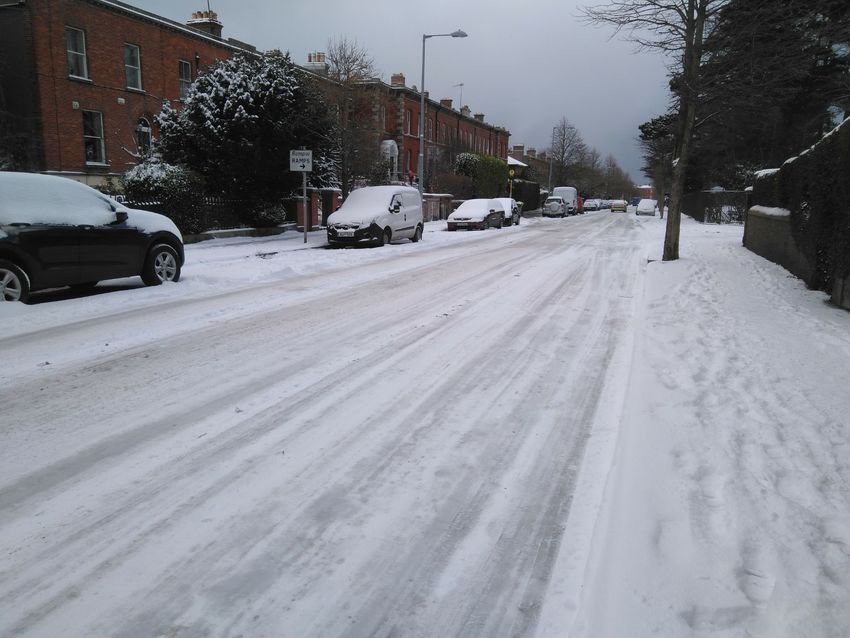
Storm Emma

                                  Table of Contents

1.       Introduction ………………………………………………………………………………………………………………………………...3

2.       Event Evolution.…………………………………………………………………………………………………………………………...4

         2.1 What is a Sudden Stratosphere Warming

         2.2 February 2018 Sudden Stratosphere Warming

         2.3 Overview of meteorological conditions leading up to Storm Emma

         2.4 Red Warnings issued by Met Éireann during the event

3.       Comparison with other Cold Spells……………………………………………………………………………………………...8

4.       Storm event analysis…………………………………………………………………………………………………………………..10

5.       Impacts ……………………………………………………………………………………………………………………………………...12

6.       Conclusions and Summary ………………………………………………………………………………………………………..13

7.       References ……………………………………………...………………………………………………………………………………...14

Appendix 1: Advisories and Warnings …………………………………………………………………………………………………..15

Appendix 2: Snow Depths ……………………………………………………………………………………………………………………..19

     Page 2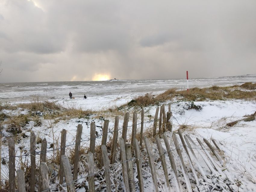
Storm Emma, An Analysis

                                             1. Introduction
Many Irish winters are free from major snowstorms, but because of its infrequent and irregular occurrence, snow in large quan-
tities causes serious disruption. A marked feature of snowfall in Ireland is its variation in depth from place to place. Some
heavy snowfalls can be quite localised. Drifting complicates measurements of snow depths. Drifts of six meters or more have
been reported in upland areas. Even in flat countryside, noticeable drifting can occur especially near buildings or on some roads
where nearby fields have much smaller depths of snow. Therefore, snow depths are recorded at locations that are relatively
free of drifting. Systematic measurements of snow depths have been recorded at our Synoptic stations since 1942.

Occasionally, in winter, significant snowfall occurs with blocking high pressure to the north of Ireland pushing the North Atlantic
jet stream and associated storm systems south, bringing an easterly Polar Continental airflow. Under these conditions, Eastern
and Midland areas are more affected. This type of pattern can follow a phenomenon called a Sudden Stratospheric Warming
(SSW). Weather in Ireland during the period 27th February to the 4th March saw temperatures drop to record lows with wide-
spread snowfalls across the country. Temperatures didn't rise above freezing even during the day as bitterly cold easterly winds
swept in over the country due to anti-cyclonic conditions over Scandinavia. This caused widespread disruptions to roads, rail
and air travel with work and school closures, as well as water shortages. A depression named ‘Emma’ further developed over
the Bay of Biscay and tracked northwards towards the country with its associated frontal systems during the first few days of
March. It yielded widespread snow, ice and record low daily maximum temperatures.

This report describes what a Sudden Stratospheric Warming is and how on the 12th February 2018, a Sudden Stratospheric
Warming influenced the synoptic weather patterns in the Northern Hemisphere a few weeks later, which led directly to the cold
spell in Ireland. It gives a detailed account of the cold spell, dubbed the ‘Beast from the East’, and storm Emma’s development
and path towards Ireland. It also provides an account of the warnings and advisories issued by Met Éireann and the impacts the
cold spell had on the country.

    Page 3
Storm Emma, An Analysis

                                               2. Event Evolution
It is now generally accepted that during the Northern Hemisphere winter, winds in the polar stratosphere play a significant role in
determining the synoptic weather patterns in the Mid Latitudes. This section of the report describes what a Sudden Stratospheric
Warming is and how a Sudden Stratospheric Warming on the 12th February 2018 led to the extremely cold Polar Continental air
mass dubbed by the media as ‘The Beast From The East’, which affected Ireland from the 28th February to the 4th March 2018.

2.1 What is a Sudden Stratosphere Warming

A Sudden Stratospheric Warming (SSW) of the atmosphere refers to a rapid jump in temperatures in the winter polar strato-
sphere, the layer of the atmosphere extending from approximately 10 km to 50 km above the ground, which can then lead to the
onset of cold weather in the troposphere (the lowest layer of atmosphere) of the mid-latitudes. This rapid stratospheric warming
(which can be up to 50 degrees Celsius in a couple of days) can be triggered by a disruption of the normal westerly flow by dis-
turbances, usually anticyclone wave breaking around areas of high pressure, propagating upwards from the troposphere into the
stratosphere.

This disruption leads to a 'wobbling' of the stratospheric jet stream (a zone of very strong westerly winds propagating around the
pool of very cold air which is present in the stratosphere over the North Pole in winter, known as The Polar Vortex). These
'wobbles' or waves, as they break, can be strong enough to weaken or even reverse the normal westerly winds in the strato-
spheric jet stream, leading to easterlies. As this is happening, the air in the stratosphere starts to collapse and compress, leading
to a rapid rise in temperature.

The easterly winds in the stratosphere eventually sink to the troposphere, the lowest layer of the atmosphere, altering weather
patterns in the northern hemisphere by pushing the jet stream further south leading to the development of blocking high pres-
sure systems at higher latitudes. Blocking highs can remain in place for several days or even weeks, causing the areas affected
by them to have the same kind of weather for an extended period of time. If these blocking highs become established between
Scandinavia and Greenland, a synoptic pattern can evolve which leads to bitterly cold air from eastern Europe/Russia or Scandi-
navia advecting in over Ireland.

Many of the extreme cold and snowy spells that occurred in the past over Ireland can be associated with SSWs, but only just
over half of SSWs lead to cold spells here. Cold spells can also occur before the onset of a SSW due to persistent high latitude
blocking setting up over Scandinavia for long periods leading to the wave breaking that causes the SSW. It is important to em-
phasise that whilst a SSW increases the chances of a cold outbreak, it doesn't guarantee one. This is because not all SSWs are
the same. Depending on the type of wave breaking the polar vortex can be displaced from the north pole while keeping its over-
all shape but weakened, or split into 2 or more separate daughter vortices such as the below scenario in 2009. A similar split also
happened in February 2018 which lead to the cold outbreak a few weeks later over Ireland.

  Figure 1 The evolution of a polar vortex collapse in J anuary 2009. P rior to the event (left), stratospheric w inds (gray arrow s) circle
counterclockwise, from west to east, around the pole. The vortex (solid black line) is nearly circular, and the temperatures at 10 hPa (roughly 31 km
in altitude) are cooler than usual. (middle) As the waves from below break in the stratosphere, the vortex elongates and wobbles (like a spinning top
    that you nudge). Temperatures warm rapidly. (right) The vortex splits into two pieces, and the winds near the pole reverse direction. (NOAA)

    Page 4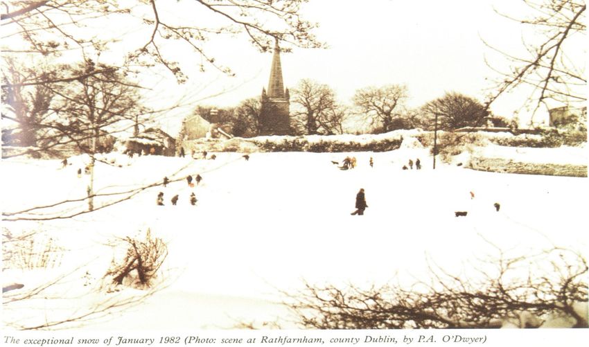
Storm Emma, An Analysis

2.2 February 2018 Sudden Stratosphere Warming

Sudden Stratospheric Warmings over the arctic tend to occur
between late November and late March, historically they are
less likely in November and December and more likely January
through to late March. If they occur after late February, it’s usu-
ally too late in the season to cause a severe cold spell here. A
schematic of typical stratospheric and tropospheric polar vorti-
ces is shown in Figure 2.

There was a split in the stratospheric polar vortex over the
north pole on the 11th February 2018 just before the SSW hap-
pened (Figure 3). One part of the vortex was pushed over Cana-
da and the other into Asia. It can take 2 weeks or more for the
reverse in the zonal winds in the stratosphere to propagate
downwards into the troposphere where our weather happens.              Figure 2 Schematic of Stratospheric and tropospheric polar vortices. Dar-
                                                                                   ryn W. Waugh, Adam H. Sobel, and Lorenzo M. Polvani

The wave breaking during this SSW was ideal for high pressure
to set up first in Scandinavia, then retrograde towards Green-
land, leading to the cold Siberian air mass moving over Ireland
from the east dubbed the ‘Beast From The East’.

The spike in the temperatures and reversal in the mean zonal
winds in the stratosphere at 60°N and 10hPa can be seen in
Figure 4, associated with the SSW.

Following a SSW, the major pattern change that is happening
present a deterministic challenge to the global weather models.
When the reverse in the zonal winds reach the troposphere the
global models start firming up on the synoptic patterns that are
likely to become established.

From the 16th February the ECMWF deterministic model picked
up the possibility of high latitude blocking building to the north
or north east around the 24th, but the following runs were in-
consistent as to where and when the high pressure would es-
tablish. From the 20th, the model runs became more consistent
as to the position and timing of the high pressure set up and
                                                                        Figure 3 EMCW F chart of Geopotential height and Temperature over the
the very cold air mass advecting around it from Siberia towards         North Pole showing the split polar vortex at 10hPa on the 11th Feb 2018 at the
Ireland, reaching us around the 27th or 28th. However there                                            onset of the SSW
was still uncertainty as to the exact position of the anticyclone.
If the high pressure stayed very close it would be cold and
mainly dry, but if the high pressure set up a bit further north a
more unstable easterly flow with snow would be more likely. In
these types of situations this is often the last piece of the puzzle
to be clarified even when the synoptic setup is accurately fore-
casted.

A typical tropospheric response to a SSW, in our area of the
Northern Hemisphere, is that low pressure systems are pushed
southwards with blocking high pressure to the north between
Scandinavia and Greenland. This explains why Storm Emma
took the track it did. After forming in the mid Atlantic on the
25th and 26th of February, it was steered by the jet stream
toward the Azores and then Portugal. Only then did it start to
move northwards towards Ireland pushing up against the estab-
lished anticyclone and cold air mass over and to the north of
Ireland.
                                                                          Figure 4 Stratospheric temperature (purple line) and w esterly zonal
                                                                       winds (gray line) from July 2017-March 2018 at approximately 32 km altitude (10
SSWs can now be reliably predicted a few weeks in advance,              hPa) and 60°N. As they do in most years, the westerly zonal winds creating the
and can be detected by observations. This gives forecasters a             Northern Hemisphere stratospheric polar vortex, formed in late August and
few weeks lead time to see how they develop and how they are             strengthened through January. As the winds strengthened, the temperatures
                                                                       dropped. When the zonal winds dipped below 0 meters/second (changed to east-
going to impact our weather.                                               erly) on February 12, a sudden stratospheric warming occurred. NOAA Cli-
                                                                                      mate.gov graph adapted from original by Amy Butler.

    Page 5
Storm Emma, An Analysis

2.3 Overview of the meteorological conditions leading up to Storm Emma

Saturday 24th and Sunday 25th February:

Ireland lay in a southeasterly airflow, as an area of High
pressure extending from Northern Europe into Russia,
began to drift westwards. At the same time storm
‘Emma’, which was named by the Portuguese Meteoro-
logical Service on the 1st of March, was forming in the
north Atlantic and moving towards the Azores.

Monday 26th to Wednesday 28th February:

The area of high pressure, of Arctic origin, had an excep-
tionally cold airmass advecting clockwise around it from
Siberia towards Ireland. On Monday and Tuesday a ridge
of high pressure had extended westwards over and to the
north of Ireland, with colder air gradually becoming es-
tablished over the country in an Easterly airflow. Daytime
                                                               Analysis chart valid 00 UTC Sunday the 25th February showing the
air temperatures fell from near normal values (5-8 de-
                                                              ’Developing Depression’ that became Storm Emma in the northwest
grees Celsius) to 1 or 2 degrees above freezing. On Tues-
                                                                          Atlantic and Ireland in a southeasterly airflow
day snow showers began to affect coasts in the South
and East as the very cold, dry, unstable air picked up
moisture from the Irish sea. During Tuesday night and
Wednesday these snow showers moved further West-
wards across the country bringing accumulation of snow
to many locations. During this period Storm Emma, had
brought heavy rain to Portugal and Spain and was situat-
ed off the west coast of Portugal, and began to move
Northwards on Wednesday night.

Thursday 1st March and Friday 2nd March:

These days were bitterly cold with daytime air tempera-
ture not rising above freezing in many locations. Early on
Thursday snow showers continued to feed in across the
country from the Irish Sea. Storm Emma continued to
move northwards and by 6pm persistent outbreaks of
snow had begun to affect the South and Southeast of the
country, and this spread to the rest of the country over-     Analysis chart valid 00 UTC Thursday the 1st March showing Storm
night. The heavy snowfall associated with Storm Emma          Emma west of Portugal pushing northwards and Ireland in a strong
occurred as the moisture-rich air associated with the                                   easterly airflow
storm, met the sub-zero temperature air mass which had
become established over Ireland and the UK. As Storm
Emma pushed against the high pressure to the north of
Ireland, it squeezed the isobars together over Ireland,
strengthening the easterly winds. These strong winds
caused drifting, blizzard conditions and extremely high
waves in the Irish Sea for a time. During Friday storm
Emma became slow-moving to the Southeast, and con-
tinued to steer bands of snow across the country, with
the East and Southeast worst affected.

Saturday 3rd and Sunday 4th March

During Saturday as storm Emma passed westwards close
to the South coast of Ireland, somewhat milder air slowly
extended Northwards across the country, with snow
showers turning to rain or sleet from the South. Sunday
saw a further slow rise in temperatures, but still some      Analysis chart valid 00 UTC on Saturday the 3rd March showing Storm
sleet or rain showers and a continuing slow thaw of lying      Emma to the southeast of Ireland with frontal bands of snow over
snow.                                                                              Ireland in an easterly airflow

    Page 6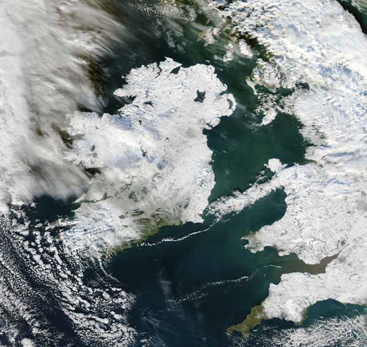
Storm Emma, An Analysis

2.4 Red Warnings issued by Met Éireann during the event.

Early on Wednesday morning the 28th February, Met Éireann issued its first Status RED Warning of the event for Dublin, Kil-
dare, Louth, Wicklow and Meath:
Heavy overnight snowfall has led to accumulations of snow between 5 and 10cm. Snow showers will continue to
occur during today and again tonight with further accumulations. Total snowfall up to midday Thursday may reach
25cm.
Warning Issued: 05:00, Wednesday the 28th February 2018

Later on Wednesday morning the 28th February, Met Éireann issued another Status RED warning, this time for Munster and
Leinster, as the developing situation regarding Storm Emma came into focus:
Blizzard-like conditions will develop in heavy snow and strong easterly winds on Thursday evening and will con-
tinue Thursday night and Friday morning giving significant snow drifts in many areas.
Warning Issued: 11:00, Wednesday the 28th February 2018

On Wednesday Evening the 28th February, Met Éireann updated its previous RED warning to include Dublin, Kildare, Louth,
Wexford, Wicklow, Meath, Cork and Waterford:
Update Further disruptive heavy snow showers are expected overnight with significant accumulations.
Warning Issued: 20:00, Wednesday the 28th February 2018

On Wednesday night the 28th February, Met Éireann further updated its RED warning to include the whole of Ireland:
Further heavy snow showers will bring accumulations of significant levels with all areas at risk. Blizzard condi-
tions will develop from the south Thursday afternoon and evening as heavy snow and strong easterly winds bring-
ing snow drifts northwards over the country. Eastern and southern coastal counties will be worst affected.
Warning Issued: 23:00, Wednesday the 28th February 2018

On Thursday afternoon the 1st of March, Met Éireann issued 2 updated RED warnings, first for Munster and Leinster:
Update: Sub-zero temperatures and further heavy snow showers this afternoon. Blizzard like conditions will de-
velop in the southeast and south this evening and extend northwards tonight. Southern and eastern coastal coun-
ties will be worst affected.
Warning Issued: 12:00, Thursday the 1st March 2018

And then for Connacht, Cavan, Monaghan and Donegal:
Update: Sub-zero temperatures and icy conditions continuing for the rest of today and tonight in strong easterly
winds. Scattered heavy snow showers will lead to significant accumulations in some areas.
Warning Issued: 13:00, Thursday the 1st March 2018

Later that day the 1st March, Met Éireann further updated their RED warnings first for Munster and Leinster:
Update: Blizzard conditions tonight and during Friday in Leinster and Munster. Southern and eastern coastal coun-
ties expected to receive exceptionally high accumulations.
Warning Issued: 18:00, Thursday the 1st March 2018

And then for Connacht, Cavan, Monaghan and Donegal:
Update: Sub-zero temperatures and icy conditions continuing tonight in strong easterly winds with heavy snow
showers and high accumulations in some areas.
Warning Issued: 19:00, Thursday the 1st March 2018

Early on Friday morning the 2nd March, Met Éireann updated their RED warning again to include Munster, Leinster and Galway:
Update: Blizzard conditions during Friday in Galway, Leinster and Munster. Exceptionally high accumulations ex-
pected in Eastern and Southern coastal areas.
Warning Issued: 00:00, Friday the 2nd March 2018

Later on Friday morning the 2nd March, Met Éireann updated their RED warning for Munster, Leinster and Galway:
Update: Snowfall will continue today across Munster, Leinster and Galway in strong easterly winds.
Warning Issued: 06:00, Friday the 2nd March 2018

On Friday afternoon the 2nd March, Met Éireann issued their final RED warning of the event to include Dublin, Kildare, Wexford,
Wicklow and Meath:
Update: Snow accumulations continuing to increase significantly due to further heavy falls of snow.
Warning Issued: 15:00, Friday the 2nd March 2018

A complete list of all Met Éireann’s advisories and warnings for the event are available in the appendix 1.
    Page 7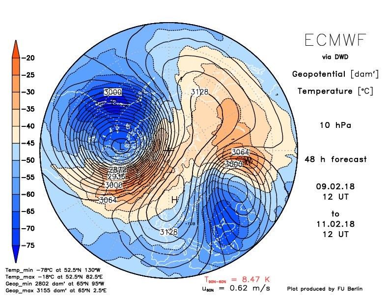
Storm Emma, An Analysis

       3. Comparison with other Severe Cold Spells
There are many historical references to severe winters in Ireland. An extraordinary snowfall, which lasted three
months, is reputed to have occurred around 764 A.D. In years 1433/1434, Ireland suffered another severe winter.
There was a great snow in 1635 (Boate, 1652). From the late 17th century onwards, weather diaries and newspapers
provided information on the weather and there are many such recorded events from the 17th and 18th centuries. From
1800 onwards, meteorological observations were recorded at an increasing number of locations and extreme cold
spells were more accurately documented. Daily observations commenced at the Phoenix Park, Dublin in 1829. There
are many such documented events from the 19th and 20th centuries but here we will concentrate on some of the
events since the 1940s.

Up to 24 SSWs have been documented between December 1st and February 20th from 1958 to 2013 by A. H. Butler et
al.: ‘A sudden stratospheric warming compendium’ and by Cohen and Jones ’ Tropospheric Precursors and Strato-
spheric Warmings’ using several reanalysis data
sets. The documented SSWs that influenced each
severe cold spell in Ireland during that time are
written in bold.

1947: The early months of 1947 saw one of the
most persistent cold spell of the century, with
snowfalls affecting all parts of the country from
late January until mid-March. Although heavier
individual snowfalls have been recorded, notably
in January 1917, at no other time in the recent
past has there been such a period of continuous
cold weather.                                           Figure 8 1947 Steam engine coming into Boyle Station

1951: Considerable snow fell on the 8th March in midland and eastern areas and was succeeded by a spell of cold east-
erly winds. Mullingar recorded a depth of snow of 15cm.

1955: A very cold northerly or easterly airstream dominated the country from the 10th to 25th February giving wintry
showers and outbreaks of snow with prolonged periods of icy roads. There were 10 consecutive days with snow lying
at Dublin Airport from 18th to 27th February where a depth of 13cm was recorded on the 22nd and 25th February.

1958: A cold north-westerly airflow set in on the 19th January, giving wintry showers, especially in the Northwest and
west Munster. Malin Head recorded a depth of snow of 20cm on the 21st February. A depth of 17cm was recorded at
Belmullet on the 24th, the greatest depth of snow recorded at this station. SSW on 31st January 1958.

1960: Snow fell countrywide on a large number of occasions in February. Dublin Airport had 9 days with snow lying
from the 11th to 19th February where a depth of 11cm was recorded on the 13th February. SSW on 17th of January
1960.

1962/63: Bitterly cold weather set in around the
Christmas period and persisted with only brief
milder periods until early March. During this peri-
od easterly winds were directed over Ireland by a
large Scandinavian anticyclone, with occasional
depressions bringing falls of snow, some of which
were heavy. On the morning of the 31st December
1962, a depth of 45 cm of snow was recorded at
Casement Aerodrome in an area where there was
no significant drifting. SSW on 28th January 1963.
                                                             Figure 9 River Shannon on 3rd January 1963
1973: Widespread snow fell during the period 14th
to 17th of February, heaviest in the Midlands. A snow depth of 25cm was recorded at Clones, Co. Monaghan. SSW on
31st January 1973.

1978/79: Appreciable falls of snow between 28th and 31st December 1978 were followed by frosts of unusual severity.
This cold spell ended on January 6th but there were further snowfalls later in the month. The highest depths of snow
recorded during this spell were Casement Aerodrome 26 cm, Claremorris 16cm and Cork Airport 15cm.

  Page 8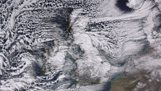
Storm Emma, An Analysis

1981/1982: A very cold December 1981 continued
into January and on the 8th January 1982 there was
widespread snow, heaviest in the East, where there
was considerable drifting due to strong easterly
winds. A severe cold spell followed and snow re-
mained on the ground until 15th January. Dublin was
badly affected. Snow was reported at most synoptic
stations with the greatest depths as follows: Dublin
Airport 25 cm, Casement Aerodrome 16 cm and Kil-
kenny 16cm. SSW on 4th December 1981.

1987: This spell started on the 11th January. By the
14th, appreciable depths of snow were reported par-
ticularly in the East and Midlands. Moderated north-
easterly winds caused drifting. Temperatures rose a
                                                      Figure 10 The Exceptional snow of January 1982 (P hoto: sce-
little above zero on the 15th and a slow thaw set in.        ne at Rathfarnham, county Dublin, by P.A. O’Dwyer
Highest snowfalls recorded were as follows: Dublin
Airport 19 cm; Casement Aerodrome 12 cm; Birr 12cm; Mullingar 12 cm. Roches Point recorded its highest ever depth of
snow at 12 cm and a minimum temperature of -7.2 degree Celsius, the lowest there since records began in 1867. SSW
on 23rd January 1987.

2000: On the 27th December a shallow polar depression crossed the north of the country, bringing outbreaks of snow,
heavy in parts of the west and north. Snow showers were widespread in all but the southeast on the 28th, giving signifi-
cant accumulation of snow in many places. A depth
of 19 cm was recorded at Knock Airport. SSW on
16th December 2000 and 11th February 2001.

2001: Bitterly cold northerly winds brought falls of
snow on the 26th – 28th February, heaviest in the
north and east. Snow depths up to 10cm were rec-
orded in the east and northwest, 75cm of snow was
measured in the Mourne Mountains on the 27th Feb-
ruary. SSW on 11th February 2001.

2009/10: This was the coldest winter since 1962/3,
temperatures were around two degrees below aver-
age. There were between 20 and 30 days with snow
in many places, mainly in the form of showers, but
snowfall accumulations were generally slight except
                                                    Figure 11 I ce and snow covered the top of Croagh P atrick, Co.
on high ground. SSW on 9th February 2010.
                                                                        Mayo, on New Year’s Day 2010.
2010/11: From the middle of November 2010, the weather turned progressively colder. By the end of the month, there
were accumulations of snow over most of the country, accompanied by extremely low temperatures. Both Dublin Airport
(-8.4°C) and Casement Aerodrome (- 9.1°C) had their lowest November temperatures on record on the 28th. The very
cold weather continued into early December with
further sleet and snow, accompanied by daytime
temperatures close to freezing and night-time val-
ues dropping below -10°C (-16°C at Mount Juliet on
3rd ). After an improvement in temperatures for 5 or
6 days, although still cold, it became extremely cold
again from 16th with snow at times leading to signif-
icant accumulations and record low December tem-
peratures. Snow depths of between 10 and 25 cm
were recorded at many locations. Casement Aero-
drome recorded a depth of 27cm. Although not a full
SSW, there were warmings in November and
December and a split polar vortex which de-
layed it strengthening into its typical winter
mode.
                                                        Figure 12 Satellite show ing I reland w as almost completely
                                                       covered by snow and ice on Christmas Day 2010, one of the coldest
                                                                        days ever recorded in Ireland.

    Page 9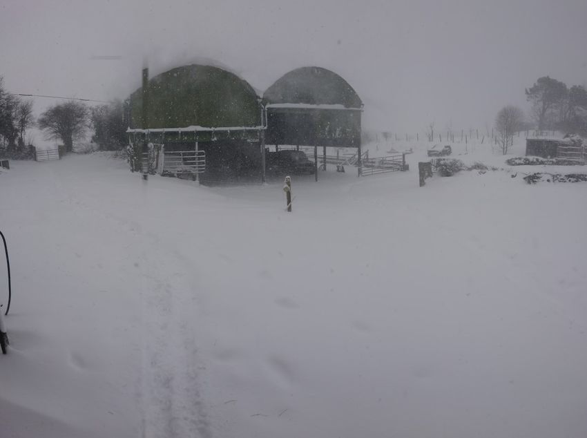
Storm Emma, An Analysis
4. Storm Event Analysis
Much of the snow that fell in the first few days of the event fell in the form of showers or bands of snow as the strong bitterly
cold easterly winds picked up moisture from the Irish sea. At first the East and Midlands received the bulk of the snow as
shown in figure 10 below, however the showers pushed well inland at times with strong winds giving accumulations in places
that might not normally receive much snow in this kind of setup. Storm Emma pushed persistent frontal snow up from the
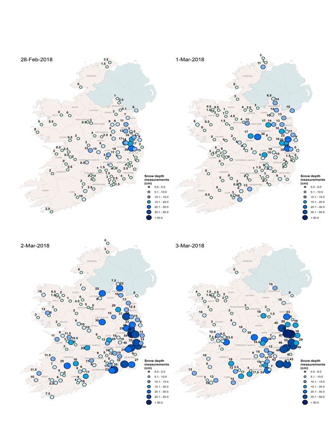
south from late on Thursday the 1st which lead to snow accumulations in many other parts of the country.
Figure 13 Snow depths recorded at Met Éireann climate and synoptic stations betw een the 28th Feb and
the 3rd March 2018.
Page 10Storm Emma, An Analysis
Table 1: Snow depths (cm) at 9am from a selection of Met Éireann stations, 28th
Feb - 4th Mar 2018 (all other snow depth measurements available in the appendix)
Station 28th Feb 1st Mar 2nd Mar 3rd Mar 4th Mar
Ardee (Co. Louth) 7 13 13 10 2
Ballyroan (Co. Laois) 11 18 20 26 12
Bunclody (Co. Wexford) 1 2 25 45 28
Cork Airport (Co. Cork) 3 5 4 14 7
Glenmacnass (Co. Wicklow) 15 15 48 69 53
Knock Airport (Co. Mayo) 0 1 1 2 2
Dun Laoghaire (Co. Dublin) 8 9 9 18 4
Dublin Airport (Co. Dublin) 5 11 15 17 13
Casement Aerodrome (Co. Dublin) 16 22 23 20 14
Mullinavat (Co. Kilkenny) 1.5 3 8 14 5
Naas (Co. Kildare) 14 16 25 45 20
Shannon Airport (Co. Clare) 0 0 3 1 0
Woodlawn (Co. Galway) 2 2 6 6 6
Snowfall was variable across the country with the South, East and Midlands recording the highest depths, especially over hills
in these areas. However, in general, amounts on snow decreased further north and west. This reflects the initial showery na-
ture of snow in the easterly flow, and also later the more general bands of frontal snow that moved up from the southeast as
Storm Emma approached. Table 1 shows snow depths recorded at a selection of stations during the event. Snow depths be-
came unmeasurable at times in some places due to significant drifting in the strong easterly winds. Drifts of over 2 meters
were measured in places.
Table 2: Maximum and minimum temperature from a selection of Met Éireann synoptic sta-
tions, 28th Feb - 2nd Mar 2018 (the coldest 3 days of the event). *record low temperatures.
Wed 28th Feb Thur 1st Mar Fri 2nd Mar
Station Max T °C Min T °C Max T °C Min T °C Max T °C Min T °C
Cork Airport (Co. Cork) -1.1 -5.1 -1.8* -7.0* -0.4 -2.3
Dublin Airport (Co. Dublin) -0.4 -4.9 -0.5* -5.1 -0.2 -1.2
Casement Aerodrome (Co. Dublin) -0.5 -4.5 -0.7* -5.1 -0.5 -1.2
Shannon Airport (Co. Clare) 0.3 0.8 0.0* -5.0 0.9 -0.8
Knock Airport (Co. Mayo) -0.5 -5.4* -1.2* -6.8* 0.9 -2.4
Johnstown Castle (Co. Wexford) 0.0* -3.8* -0.2* -3.8* -0.1 -1.1
Finner (Co. Donegal) 0.9* -4.5 0.8* -5.0 2.0 -0.3
Valentia Obs. (Co. Kerry) 2.0 -3.0 0.7* -5.0 1.5 -1.2
Mullingar (Co. Westmeath) -0.5 -4.8 -0.8* -5.1 1.3 -1.0
Ice days, where the maximum temperature in a day does not rise above freezing, are very rare in Ireland on lower ground.
During this event, ice days were recorded at a number of stations on the 28th February and on the 1st March 2018. This is the
only time since at least 1942 (as far as our digitised records go back), that ice days were recorded in Ireland in March at any
Met Éireann stations. There were a number of stations that had record low maximums for March and a few stations with record
low maximum for February. A few stations, such as Cork Airport and Knock Airport also had record low minimum temperatures
for March on the 1st. This is illustrated in table 2.
Page 11Storm Emma, An Analysis
5. Impacts
The impacts of Storm Emma and ‘The Beast from the East’
were widespread across the country. Although most people
heeded the warnings not to travel, there was severe disrup-
tion to the transport network. Deep drifting on roads was a
major issue causing cars to be abandoned in many places.
Travel:
Air transport was severely disrupted with over 70,000 air
passengers stranded due to flight cancellations and air-
ports closures.
Some remote locations were cut off for a number of days
due to the heavy snow and drifting making roads im-
passable.
Many colleges, schools and businesses shut down.
Public transport nationwide including bus, rail and Luas Figure 14 Snow on the beach, Skerries Co Dublin on the
came to a stand still due to widespread cancellations to 28th February.
services.
Many ferry services were cancelled.
Power outages and water:
The ESB said over 100,000 homes and businesses lost
power.
More than 10,000 eir customers were without telephone,
broadband and mobile services.
18,000 people without water across the country.
Disruption to other services:
Fire crews had to assist ambulances in getting to some
calls while other crews had to dig themselves out.
Fire service and civil defence personnel assisted key
workers in the HSE, hospitals and wider community to
get to work in extremely difficult conditions. Figure 15 Road conditions in Dublin City on the 28th Feb-
There was closures to sports and leisure centres , public ruary were treacherous.
libraries, community centres, swimming pools and other
public offices and facilities.
Some coastal flooding in towns along the East and South
coasts was reported during high tides.
Farming:
Some farmers, especially the Southeast and East, suf-
fered significant losses. A number of sheds collapsed due
to the weight of the snow leading to the loss of livestock
and machinery.
There was fodder shortages and food shortages as farm-
ers struggled to get supplies to supermarkets.
Growers in the soft fruit and nursery stock sectors were
also badly hit by the heavy snowfall with tunnels and
glass houses collapsing.
Figure 16 A farm in M ullingar on the 28th February
Page 12Storm Emma, An Analysis
6. Conclusions and Summary
This was the most significant spell of snow and low temperatures to affect Ireland since December 2010. The synoptic setup
however, compares more favourably to the cold spell in January 1982 with large snowfall totals and blizzard conditions affect-
ing the East and South especially. Both the 1982 and 2018 cold spells followed several weeks after Sudden Stratospheric
Warming (SSW) events.
When a SSW of the atmosphere occurs in the northern hemisphere in winter, it causes a rapid rise in temperatures in the
polar stratosphere and a reversal in the zonal winds that sometimes leads to a cold spell over Ireland several weeks later.
Our prevailing wind direction is from the west, giving us relatively mild Atlantic air. Sometimes after a SSW however, an
easterly airflow can set up with high pressure forming between Scandinavia and Greenland. This blocks the mild Atlantic air
and brings in cold air from the east. Currently we can reliably predict individual SSWs about 2 weeks in advance, but we can-
not yet predict which SSWs will lead to cold spells over Ireland and which ones will not. What is understood however, is that
SSWs increase the chances of a cold spell with snowfall occurring.
This event started with high pressure setting up over Scandinavia feeding an exceptionally cold airmass towards the UK and
Ireland from Siberia. The snow showers started on Tuesday the 27th, affecting the East of the country first, but penetrated
inland more and more in the strong easterly winds over the following few days giving accumulations of snow in many loca-
tions. The snow stayed on the ground as the temperatures stayed below freezing even during the day. Storm Emma ap-
proached from the south on Thursday evening squeezing the isobars together even further, thus increasing the strength of
the easterly wind, and sending frontal bands of snow northwards giving blizzard conditions and significant drifting.
The country effectively came to a standstill for several days. There was widespread disruption to the road network with many
roads impassable. Public transport shut down in most locations as people were advised to stay indoors. It was not a particu-
larly long lasting spell but it had severe impacts. Naas Co. Kildare and Bunclody Co. Wexford reported 45 cm of snow on the
ground on the 3rd of March, with Glenmacnass in Co. Wicklow reporting 69 cm. The very strong easterly winds led to signifi-
cant drifting with up to 7 meter drifts reported in Wicklow and Wexford. The M2 buoy recorded a maximum individual wave
of 9.84 m on the 2nd March. The previous highest was 9.6 m recorded on the 30th December 2015. This buoy has been op-
erating since 2001. Temperatures were also record breaking with record low daily maximum temperatures for March being
reported in many locations on the 1st. This is the first time since digitised records began in 1942 that ice days, where the
temperature doesn't rise above freezing for the whole day, were reported at any of our stations in March.
The communication of Met Éireann’s weather advisories, forecasts and warnings played a pivotal role in helping the country
prepare for, and manage its way through this event. Met Éireann also contributed to the briefings at the NECG (National
Emergency Coordination Group) meetings. The synoptic configuration for this event was accurately forecasted from the 20th
February onwards. Met Éireann issued its first advisory for the event on Friday the 23rd stating that disruptive snow and ex-
ceptionally cold weather was expected from the following Tuesday the 27th onwards. As the event came closer Met Éireann
used its high resolution 54-hour Harmonie model to forecast specifics on where and how much snow would fall, however the
initial showery nature of the snow made it very difficult to pinpoint the intensity and location of the showers, and on the
morning of the 28th February Met Éireann issued its first red warning.
The Fifth Assessment report (AR5) of the Intergovernmental Panel on Climate Change (IPCC) concluded that ‘human influ-
ence on the climate system is clear’ and that ‘changes in many extreme weather and climate events have been observed
since about 1950’. An increase in the frequency of extreme weather events has been attributed to climate change and is
linked to human activity. Climate attribution of SSW events has received less attention. Some recent studies suggest an in-
creased frequency of SSW events in a warming climate, but the mechanisms that trigger SSW and the way in which these will
be affected by climate change need to be better understood in order to predict whether SSWs will be more frequent in the
future.
Page 13Storm Emma, An Analysis
7. References
Butler, Amy H., et al. “A Sudden Stratospheric Warming Compendium.” Earth System Science Data, vol. 9, no. 1, 2017, pp. 63
–76., doi:10.5194/essd-9-63-2017.
Cohen, Judah, and Justin Jones. “Tropospheric Precursors and Stratospheric Warmings.” Journal of Climate, vol. 24, no. 24,
2011, pp. 6562–6572., doi:10.1175/2011jcli4160.1.
Office, Met. “Sudden Stratospheric Warming.” Met Office, Met Office, 5 Jan. 2019, www.metoffice.gov.uk/learning/wind/sudden
-stratospheric-warming.
Galvin, Jim. “The Accumulation of Snow in February and March 2018.” Met Office, 2018, www.metoffice.gov.uk/climate/uk/
interesting/february2018-snow.
Finnis, Nick. “Sudden Stratospheric Warming This Weekend, But What Is It & How Will It Affect Our Weather? - Blog by Nick
Finnis.” Netweather, Netweather, 9 Feb. 2018, www.netweather.tv/weather-forecasts/news/8730-sudden-stratospheric-
warming-this-weekend-but-what-is-it-how-will-it-affect-our-weather.
Murphy, Aidan. “Snowfall in Ireland.” Met.ie, 2012, www.met.ie/cms/assets/uploads/2018/11/SnowfallAnal.pdf.
Figure 1 Butler, Amy H. “El Niño and the Stratospheric Polar Vortex.” Climate Change: Global Sea Level | NOAA Climate.gov,
28 Apr. 2016, www.climate.gov/news-features/blogs/enso/el-ni%C3%B1o-and-stratospheric-polar-vortex.
Figure 2 W augh, Darryn W , et al. “WHAT IS THE POLAR VORTEX AND HOW DOES IT INFLUENCE WEATHER?” Columbia.edu,
2017, www.columbia.edu/~lmp/paps/waugh+sobel+polvani-BAMS-2017.pdf.
Figure 3 Berlin, FU. “EMCWF Chart of Geopotential Height and Temperature over the North Pole.” Www.geo.fu-Berlin.de,
2018, www.geo.fu-berlin.de/en/met/ag/strat/produkte/winterdiagnostics/index.html#.
Figure 4 Butler, Amy H. “Winds and temperature during the 2017-2018 winter.” Climate.gov, 27 Apr. 2018,
www.climate.gov/news-features/blogs/enso/february-and-march-madness-how-winds-miles-above-arctic-may-have-brought.
Edited by: Paul Moore
Report contributors: Liz Coleman, Alan Hally, Aidan Murphy, Anca Turcu, Seamus Walsh, Valerie Watters, Laura Zubiate
Page 14Storm Emma, An Analysis
Appendix 1: Advisories and Warnings
Issue Date,
Time Level Area Text valid from valid to
Exceptionally cold weather is forecast
for next week with significant wind chill
12:00 hours Friday, Weather Advi- and severe frosts. Disruptive snow 12:00 hours Fri, 23-Feb- 12:00 hours Fri, 02-Mar-
Ireland
23-Feb-2018 sory showers are expected from Tuesday 2018 2018
onwards, particularly in the east and
southeast.
Update on previous Advisory. Excep-
tionally cold weather is forecast for
next week with significant wind chill
and severe frosts. Disruptive snow
17:00 hours Satur- Weather Advi- 00:00 hours Tue, 27-Feb- 18:00 hours Sat, 03-Mar-
Ireland showers are expected from Tuesday
day, 24-Feb-2018 sory 2018 2018
onwards, particularly in the east and
southeast. Snow showers perhaps
merging into more persistent bands of
snow from midweek.
Update on previous Advisory. Excep-
tionally cold weather will occur this
week. Air and ground temperatures will
be 5 to 10 degrees below normal, with
significant wind chill and penetrating
11:00 hours Sunday, Weather Advi- 00:00 hours Tue, 27-Feb- 18:00 hours Sat, 03-Mar-
Ireland severe frosts. Snow showers, mainly
25-Feb-2018 sory 2018 2018
affecting eastern areas on Tuesday, will
progressively become more widespread
and heavier through midweek, with
significant and disruptive accumula-
tions.
Exceptionally cold weather will occur
this week. Air and ground temperatures
will be 5 to 10 degrees below normal,
with significant wind chill and pene-
trating severe frosts. Snow showers,
mainly affecting eastern areas on Tues-
11:00 hours
Weather Advi- day, will progressively become more Valid from 00:00 hours Tue, Valid until 18:00 hours Sat,
Monday, 26-Feb-
sory widespread and heavier through mid- 27-Feb-2018 03-Mar-2018
2018
week. A spell of persistent and heavy
snow is expected to extend from the
south late Thursday and Thursday
night, with significant and disruptive
accumulations. Please also see win-
terready.ie.
Scattered snow showers later Tuesday
and Tuesday night will lead to accumu-
11:00 hours Weather Dublin, Carlow, Kildare,
lations of 4 to 6 cm by Wednesday Valid from 15:00 hours Tue, Valid until 11:00 hours
Monday, 26-Feb- Warning Or- Laois, Louth, Wicklow
morning. Widespread frost and icy 27-Feb-2018 Wed, 28-Feb-2018
2018 ange and Meath
conditions also. Updates to follow.
Please see Weather Advisory.
Scattered snow showers later Tuesday
and Tuesday night will lead to accumu-
11:00 hours Kilkenny, Longford,
Weather Alert lations of up to 3 cm in some parts by Valid from 18:00 hours Tue, Valid until 11:00 hours
Monday, 26-Feb- Wexford, Offaly, West-
Yellow Wednesday morning. Widespread frost 27-Feb-2018 Wed, 28-Feb-2018
2018 meath, Cork,
and icy conditions also. Updates to
follow. Please see Weather Advisory.
11:00 hours Air temperatures of 0 to minus 5 Celsi-
Weather Alert Valid from 17:00 hours Valid until 12:00 hours Tue,
Monday, 26-Feb- For Ireland us tonight, with widespread severe
Yellow Mon, 26-Feb-2018 27-Feb-2018
2018 frost.
Very cold overnight with temperatures
falling to between -1 and -5 degrees
17:00 hours Tuesday, Celsius, possibly slightly lower in some 18:00 hours Tue, 27-Feb- 11:00 hours Wed, 28-Feb-
Yellow For Ireland
27-Feb-2018 western and Northwestern counties 2018 2018
and temperatures tomorrow struggling
to get above zero
Page 15Storm Emma, An Analysis
Appendix 1: Advisories and Warnings
Heavy overnight snowfall has led to
accumulations of snow between 5 and
at 05:00 hours 10cm. Snow showers will continue to
Dublin, Kildare, Louth, 05:00 hours Wed, 28-Feb- 12:00 hours Thu, 01-Mar-
Wednesday, 28-Feb- Red occur during today and again tonight
Wicklow and Meath 2018 2018
2018 with further accumulations. Total snow-
fall up to midday Thursday may reach
25cm.
Heavy snow showers will continue
06:00 hours Wednes- Wexford, Cork and today, tonight and during tomorrow for 06:00 hours Wed, 28-Feb- 12:00 hours Thu, 01-Mar-
Orange
day, 28-Feb-2018 Waterford Wexford, Waterford and south Cork 2018 2018
with snow accumulations up to 8cm.
Carlow, Kilkenny, Laois,
Longford, Wexford, Update: Scattered heavy snow showers
08:00 hours Wednes- 06:00 hours Wed, 28-Feb- 12:00 hours Thu, 01-Mar-
Orange Offaly, Westmeath, continuing today, tonight and tomorrow
day, 28-Feb-2018 2018 2018
Cork, Tipperary and with further accumulations.
Waterford.
08:00 Wednesday, 28 Donegal, Galway, Clare Scattered heavy snow showers today, 08:00 hours Wed, 28-Feb- 12:00 hours Thu, 01-Mar-
Yellow
-Feb-2018 and Limerick tonight, and tomorrow. 2018 2018
Connacht, Cavan, Mon-
11:00 hours Wednes- Scattered heavy snow showers today, 08:00 hours Wed, 28-Feb- 12:00 hours Thu, 01-Mar-
Yellow aghan, Donegal, Clare
day, 28-Feb-2018 tonight, and tomorrow. 2018 2018
and Limerick
Blizzard-like conditions will develop in
heavy snow and strong easterly winds
11:00 hours Wednes- on Thursday evening and will continue 16:00 hours Thu, 01-Mar- 12:00 hours Fri, 02-Mar-
Red Munster and Leinster
day, 28-Feb-2018 Thursday night and Friday morning 2018 2018
giving significant snow drifts in many
areas.
Persistent snow will develop on Thurs-
11:00 hours Wednes- Connacht, Cavan and day night and will continue into Friday. 20:00 hours Thu, 01-Mar- 12:00 hours Fri, 02-Mar-
Orange
day, 28-Feb-2018 Monaghan Together with strong easterly winds this 2018 2018
may lead to snow drifts.
Update: Showers will be more scattered
14:00 hours Wednes- Dublin, Kildare, Louth, this afternoon, but further heavy snow 14:00 hours Wed, 28-Feb- 12:00 hours Thu, 01-Mar-
Orange
day, 28-Feb-2018 Wicklow and Meath showers are expected over night with 2018 2018
significant accumulations.
Update Showers will be more scattered
14:00 hours Wednes- Dublin, Kildare, Louth, this afternoon, but further heavy snow 14:00 hours Wed, 28-Feb- 12:00 hours Thu, 01-Mar-
Red
day, 28-Feb-2018 Wicklow and Meath showers are expected overnight with 2018 2018
significant accumulations.
Carlow, Kilkenny, Laois,
Longford, Wexford, Update: Scattered heavy snow showers
17:00 hours Wednes- 06:00 hours Wed, 28-Feb- 12:00 hours Thu, 01-Mar-
Orange Offaly, Westmeath, continuing tonight and tomorrow with
day, 28-Feb-2018 2018 2018
Cork, Tipperary and further accumulations.
Waterford
Persistent snow will develop on Thurs-
17:00 hours Wednes- Connacht, Cavan, Mon- day night and will continue into Friday. 20:00 hours Thu, 01-Mar- 12:00 hours Fri, 02-Mar-
Orange
day, 28-Feb-2018 aghan and Donegal Together with strong easterly winds this 2018 2018
may lead to snow drifts.
Update: Further disruptive heavy snow
17:00 hours Wednes- Dublin, Kildare, Louth, 15:00 hours Wed, 28-Feb- 12:00 hours Thur, 01-Mar-
Red showers are expected overnight with
day, 28-Feb-2018 Wicklow and Meath 2018 2018
significant accumulations.
Carlow, Kilkenny, Laois,
Further snow showers tonight and on
17:00 hours Wednes- Longford, Wexford, 17:00 hours Thu, 01-Mar- 12:00 hours Thu, 01-Mar-
Orange Thursday morning with significant accu-
day, 28-Feb-2018 Offaly, Westmeath, 2018 2018
mulations expected.
Cavan, Galway and Cork
Donegal, Monaghan,
Leitrim, Mayo, Roscom- Update: Scattered snow showers to-
17:00 hours Wednes- 17:00 hours Thu, 01-Mar- 12:00 hours Thu, 01-Mar-
Yellow mon, Sligo, Clare, Kerry, night and on Thursday morning with
day, 28-Feb-2018 2018 2018
Limerick, Tipperary and some accumulations.
Waterford
Dublin, Kildare, Louth, Update Further disruptive heavy snow
20:00 hours Wednes- 20:00 hours Wed, 28-Feb- 12:00 hours Thu, 01-Mar-
Red Wexford, Meath, Cork showers are expected overnight with
day, 28-Feb-2018 2018 2018
and Waterford significant accumulations.
Page 16Storm Emma, An Analysis
Appendix 1: Advisories and Warnings
Carlow, Kilkenny, Laois,
Update Further snow showers tonight
20:00 Wednesday, 28 Longford, Wexford, 20:00 hours Thu, 01-Mar- 12:00 hours Thu, 01-Mar-
Orange and on Thursday morning with signifi-
-Feb-2018 Offaly, Westmeath, 2018 2018
cant accumulations expected.
Cavan and Galway
Donegal, Monaghan,
Scattered snow showers tonight and on
20:00 Wednesday, 28 Leitrim, Mayo, Roscom- 20:00 hours Thu, 01-Mar- 12:00 hours Thu, 01-Mar-
Yellow Thursday morning with some accumula-
-Feb-2018 mon, Sligo, Clare, Kerry, 2018 2018
tions.
Limerick and Tipperary
Persistent snow will develop on Thurs-
21:00 Wednesday, 28 Connacht, Cavan, Mon- day night and will continue into Friday. 20:00 hours Thu, 01-Mar- 12:00 hours Fri, 02-Mar-
Orange
-Feb-2018 aghan and Donegal Together with strong easterly winds this 2018 2018
may lead to snow drifts.
Persistent snow will develop on Thurs-
21:00 Wednesday, 28 Connacht, Cavan, Mon- day night and will continue into Friday. 20:00 hours Thu, 01-Mar- 12:00 hours Fri, 02-Mar-
Orange
-Feb-2018 aghan and Donegal Together with strong easterly winds this 2018 2018
may lead to snow drifts.
Further heavy snow showers will bring
accumulations of significant levels with
all areas at risk. Blizzard conditions will
develop from the south Thursday after-
23:00 Wednesday, 28 noon and evening as heavy snow and 23:00 Wednesday, 28-Feb- 15:00 hours Fri, 02-Mar-
Red Ireland
-Feb-2018 strong easterly winds bring snow drifts 2018 2018
northwards over the country. Eastern
and southern coastal counties will be
and southern coastal counties will be
worst affected.
Update: Sub-zero temperatures and
further heavy snow showers this after-
noon. Blizzard like conditions will devel-
12:00 Thursday, 01- 13:00 hours Thu, 01-Mar- 12:00 hours Fri, 02-Mar-
Red Munster and Leinster op in the southeast and south this even-
Mar-2018 2018 2018
ing and extend northwards tonight.
Southern and eastern coastal counties
will be worst affected.
Update: Sub-zero temperatures and icy
conditions continuing for the rest of
13:00 Thursday, 01- Connacht, Cavan, Mon- today and tonight in strong easterly 13:00 hours Thu, 01-Mar- 06:00 hours Fri, 02-Mar-
Red
Mar-2018 aghan and Donegal winds. Scattered heavy snow showers 2018 2018
will lead to significant accumulations in
some areas.
Update: Blizzard conditions tonight and
18:00 Thursday, 01- during Friday in Leinster and Munster. 19:00 hours Thu, 01-Mar- 18:00 hours Fri, 02-Mar-
Red Munster and Leinster
Mar-2018 Southern and eastern coastal counties 2018 2018
expected to receive exceptionally high
Update: Sub-zero temperatures and icy
19:00 Thursday, 01- Connacht, Cavan, Mon- conditions continuing tonight in strong 19:00 hours Thu, 01-Mar- 06:00 hours Fri, 02-Mar-
Red
Mar-2018 aghan and Donegal easterly winds with heavy snow show- 2018 2018
ers and high accumulations in some
00:00 Friday, 02-Mar- Munster, Leinster and Update: Scattered heavy snow showers 00:00 hours Fri, 02-Mar- 18:00 hours Fri, 02-Mar-
Red
2018 Galway and icy conditions during Friday. 2018 2018
Update: Blizzard conditions during
00:00 Friday, 02-Mar- Munster, Leinster and Friday in Galway, Leinster and Munster. 00:00 hours Fri, 02-Mar- 18:00 hours Fri, 02-Mar-
Red
2018 Galway Exceptionally high accumulations ex- 2018 2018
pected in Eastern and Southern coastal
Cavan, Monaghan,
00:00 Friday, 02-Mar- Update: Scattered heavy snow showers 00:00 hours Fri, 02-Mar- 18:00 hours Fri, 02-Mar-
Orange Donegal, Leitrim, Mayo,
2018 and icy conditions during Friday. 2018 2018
Roscommon and Sligo
Snowfall will continue today across
06:00 Friday, 02-Mar- Munster, Leinster and 06:00 hours Fri, 02-Mar- 18:00 hours Fri, 02-Mar-
Red Munster, Leinster and Galway in strong
2018 Galway 2018 2018
easterly winds.
Dublin, Kildare, Wex- Update: Snow accumulations continuing
15:00 Friday, 02-Mar- 16:00 hours Fri, 02-Mar- 09:00 hours Sat, 03-Mar-
Red ford, Wicklow and to increase significantly due to further
2018 2018 2018
Meath heavy falls of snow.
Page 17Storm Emma, An Analysis
Appendix 1: Advisories and Warnings
Munster, Carlow, Kil-
15:00 Friday, 02-Mar- kenny, Laois, Longford, Snow accumulations continuing to 16:00 hours Fri, 02-Mar- 09:00 hours Sat, 03-Mar-
Orange
2018 Louth, Offaly, West- increase due to further falls of snow. 2018 2018
meath, Cavan, Mona-
15:00 Friday, 02-Mar- Donegal, Leitrim, Mayo, 16:00 hours Fri, 02-Mar- 09:00 hours Sat, 03-Mar-
Yellow Scattered snow showers
2018 Roscommon and Sligo 2018 2018
Snow accumulations continuing to
20:00 Friday, 02-Mar- Kildare, Louth and Mun- increase overnight, in strong easterly 20:00 hours Fri, 02-Mar- 09:00 hours Sat, 03-Mar-
Orange
2018 ster winds. Snow turning to rain/sleet and 2018 2018
easing early Saturday
Update: Some snow this morning, wide-
spread treacherous surfaces due to ice
06:00 Saturday, 03- Munster, Leinster, Cav- and lying snow. Rain will begin to 07:00 hours Sat, 03-Mar- 18:00 hours Sat, 03-Mar-
Orange
Mar-2018 an and Monaghan spread from the south today and this 2018 2018
will start the melting process with po-
tential flooding. Updates will follow.
06:00 Saturday, 03- Some snow today with treacherous 07:00 hours Sat, 03-Mar- 18:00 hours Sat, 03-Mar-
Yellow Connacht and Donegal
Mar-2018 surfaces due to ice and lying snow. 2018 2018
Widespread lying snow and ice will
continue to lead to hazardous condi-
08:00 Sunday, 04-Mar Munster, Leinster, Cav- tions. River levels will rise due to snow 08:00 hours Sun, 04-Mar- 12:00 hours Sun, 04-Mar-
Orange
-2018 an and Monaghan melt, leading to localised flooding, 2018 2018
especially in mountainous catchments
and in urban areas.
Widespread lying snow and ice will
continue to lead to hazardous condi-
Leinster, Cavan, Mona- tions. There will be a risk of localised
12:00 Sunday, 04-Mar 12:00 hours Sun, 04-Mar- 12:00 hours Mon, 05-Mar-
Orange ghan, Cork, Tipperary flooding due to rising river levels and
-2018 2018 2018
and Waterford there will be areas of surface water
pooling. Mountainous catchments and
urban areas most affected.
Connacht, Donegal,
11:00 Sunday, 04-Mar Lying snow and ice will continue to 12:00 hours Sun, 04-Mar- 12:00 hours Mon, 05-Mar-
Yellow Clare, Kerry and Limer-
-2018 cause hazardous conditions 2018 2018
ick
Deep lying snow remaining in places. A
09:00 Monday, 05- continuing potential for localized flood- 10:00 hours Mon, 05-Mar- 10:00 hours Tue, 06-Mar-
Orange Leinster
Mar-2018 ing due to the thaw. Frost and icy condi- 2018 2018
tions tonight and Tuesday morning.
Page 18Storm Emma, An Analysis
Appendix 2: Snow Depths
Snow depths (cm) at Met Éireann climatological and synoptic stations, 28 February - 5 March 2018
28th Feb 1st Mar 2nd Mar 3rd Mar 4th Mar 5th Mar
Ardee (Co. Louth) 7 13 13 10 2
Ardfinnan (Co. Tipperary) 2 3 8
Arklow (Co. Wicklow) 0 14 20
Ashford (Co. Wicklow) 14 18 6
Athenry (Co. Galway) 0.5 4
Athlone (Co. Westmeath) 4 17
Athy (Co. Kildare) 10 10 10 7
Aughrim (Co. Wicklow) 1 1.5 33 35
Bailieboro (Co. Cavan) 2 10
Ballina (Co. Mayo) 0.5 2 2.5
Ballinagare (Co. Roscommon) 4.5 4.5
Ballinamore (Co. Leitrim) 2.5
Ballincurrig (Co. Cork) 7 8 17 17
Ballyconnell (Co. Cavan) 3 25
Ballycroy (Co. Mayo) 10 4
Ballyhaunis (Co. Mayo) 1.5
Ballyhooley (Co. Cork) 6 12
Ballymore (Co. Westmeath)
Ballyroan (Co. Laois) 11 18 20 26 12
Ballyshannon (Co. Donegal) 2 2 2 2
Blessington (Co. Wicklow) 17 20 45
Bruckless (Co. Donegal) 0 0 0 0
Bunclody (Co. Wexford) 1 2 25 45 28 16
Cahir (Co. Tipperary) 1
Callan (Co. Kilkenny) 1.5 1.5 5 15
Cappoquin (Co. Waterford) 4
Carheeny Beg (Co. Galway) 2.5 6 11.5 6.5 0
Carndonagh (Co. Donegal) 2.5 3
Carnew (Co. Wicklow) 1 2 40 46
Carrick-on-Suir (Co. Tipperary) 1 4 10
Carrigallen (Co. Leitrim) 8
Carron (Co. Clare) 0.5 5 9 10.5 4
Casement Aerodrome (Co. Dublin) 16 22 23 20 14 9
Castlebridge (Co. Wexford) 5
Page 19You can also read