WOOD COUNTY OHIO Severe Weather Plan 2020
←
→
Page content transcription
If your browser does not render page correctly, please read the page content below
WOOD COUNTY OHIO
Severe Weather Plan

       2020
                 1|Page
Table of Contents
Executive Summary………………………………………………………………………………………………………………………………..3
Purpose………………………………………………………………………………………………………………………………………………..…3
Scope………………………………………………………………………………………………………………………………………………………3
Concept of Operations…………………………………………………………………………………………………………………………….4
Protection Priorities……………………………………………………………………………………………………………………4
Critical Infrastructure…………………………………………………………………………………………………………………4
Vulnerable Populations………………………………………………………………………………………………………………4
Pre-event Actions……………………………………………………………………………………………………………………….5
General Response Actions………………………………………………………………………………………………………….6
History…………………………………………………………………………………………………………………………………………………….6
Types of Severe Weather…………………………………………………………………………………………………………………………6
Advisory/ Watch/ Warning Definitions……………………………………………………………………………………….6
Wind…………………………………………………………………………………………………………………………………………..7
o Derecho………………………………………………………………………………………………………………………….7
o Hail…………………………………………………………………………………………………………………………………7
o Straight Line Winds………………………………………………………………………………………………………..7
o Tornado………………………………………………………………………………………………………………………….7
NWS Radar Terminology……………………………………………………………………………………………………………..7
Winter Weather………………………………………………………………………………………………………………………….7
o Blizzard…………………………………………………………………………………………………………………………..7
o Freezing rain…………………………………………………………………………………………………………………..7
o Ice………………………………………………………………………………………………………………………………….7
o Snow………………………………………………………………………………………………………………………………7
o Snow Squall……………………………………………………………………………………………………………………8
o Temperature Extremes…………………………………………………………………………………………………..8
Heat…………………………………………………………………………………………………………………..8
Wind Chill (Cold)………………………………………………………………………………………………..8
o Flooding…………………………………………………………………………………………………………………………8
o Fog…………………………………………………………………………………………………………………………………8
Alerts/Public Mass Notification Systems………………………………………………………………………………………………….8
Code Red…………………………………………………………………………………………………………………………………….8
Outdoor Warning Sirens................................................................................................................9
NOAA (NWR )Radio…………………………………………………………………………………………………………………….9
Electronic Weather Access……………………………………………………………………………………………………….10
o Internet Weather Website……………………………………………………………………………………………10
o Cell Phone Apps……………………………………………………………………………………………………………10
o Local Media………………………………………………………………………………………………………………….10
Wood County EMA……………………………………………………………………………………………………………………10
First Responders……………………………………………………………………………………………………………………….11
Emergency Operations Center……………………………………………………………………………………………………………….11
Activation Levels……………………………………………………………………………………………………………………….12
Reporting to NWS……………………………………………………………………………………………………………………..12
2|PageSevere Weather Guidelines……………………………………………………………………………………………………………………12
Weather Spotters/Skywarn Activation Criteria………………………………………………………………………….12
Tornado Activation……………………………………………………………………………………………………………………13
Confirmed vs Non-Confirmed……………………………………………………………………………………………………13
Severe Weather Shelters…………………………………………………………………………………………………………..13
Winter Storms…………………………………………………………………………………………………………………………..14
o Sheriff Snow Emergency Levels…………………………………………………………………………………….15
Public Education…………………………………………………………………………………………………………………………………….16
EXECUTIVE SUMMARY
The Wood County Emergency Management Agency (EMA) is committed in preparing our community to
increase our resiliency. As the seventh largest Ohio County per the 2010 U.S Census of 617 square
miles, this provides diverse regional challenges. The 2018 Wood County All-Hazards Multi-Jurisdictional
Mitigation Plan identified that severe weather impacts the daily quality of life and commerce more than
any other hazard.
When a severe weather event occurs, it is imperative recovery happen as soon as possible. The best
way to expedite the recovery phase to ensure all partners are engaged and well prepared before the
event occurs. The Wood County EMA is committed to provide the current and appropriate information
to all of our partners.
As severe weather is projected, the Wood County EMA will maintain situation awareness internally and
with our partners. The most recent, accurate information gathered from multiple sources will be used.
Information gained will be presented to our partners (email, social media) as appropriate to allow all of
them to prepare.
To provide additional assistance to our partners, this plan will be published on our website and made
available at our office. Our partners are encouraged to review and use the resources listed (such as
NOAA NWR (weather radio), weather websites/apps and media information.)
PURPOSE
Severe weather can impact the daily quality of life of our residents as well as bring commerce to a
standstill. During a major weather event, the path to ensure a return to a pre-event state is
coordination between local, county and state government, nongovernmental agencies, volunteer
groups, civic organizations and those directly impacted.
The Wood County Severe Weather Plan is implemented to coordinate and ensure the timely notification
and proper response for those who may be impacted.
SCOPE
Wood County has a long history of experiencing severe weather events during all times of the year.
Wind, tornado, ice storms and large snow events cause damage to structures, utilities, infrastructure,
agriculture, wildlife, trees, etc. Large rain events overwhelm natural drainage systems, ditches and
municipal sewer systems.
3|PageThe Wood County Severe Weather Plan is for timely notification of all public safety, support services and
the general public during potential and actual severe weather events. Public safety agencies in Wood
County shall act to alert citizens throughout the county in the most appropriate and timely manner to
prevent or minimize loss of life and property based upon the type of event occurring.
CONCEPT OF OPERATIONS
All activities performed under this plan will conform to the Wood County Emergency Operations
Plan.
The National Weather Service has the primary responsibility for providing alerts to local
government as well as issuing watches and warnings to the public.
The Wood County Emergency Management Agency is responsible for monitoring and alerting
key departmental personnel of approaching severe weather.
Protection Priorities
Protection priorities as identified in the Wood County Severe Weather Plan include:
Save Human Lives
Save Animals
Protect Property
Protect the Environment
Stabilize the Economy
Restore the Community to Pre-event State
Critical Infrastructure
The Patriot Act of 2001 defines critical infrastructure as “system and assets, whether physical or virtual,
so vital to the United States that incapacity or destruction of such systems and assets would have a
debilitating impact on security, national economic security, national public health or safety, or any
combination of those matters.”
Critical infrastructure in Wood County is to be considered but not limited to: Life Safety (hospitals,
dialysis centers, police and fire station, Sheriff’s Communication Center), Utilities (water, electricity,
natural gas, propane and sewer), Transportation (county, state, township and city roads, railway and
airport), Support (American Red Cross Shelters, grocery stores, pharmacies, schools, churches,
government buildings, BGSU).
Vulnerable Populations
Vulnerable populations include a very broad range of people including, but not limited to, those with
access and functional needs, the sick, elderly, and very young. These residents have additional needs
before, during and after an event in functional areas, including but not limited to:
Maintaining independence
Communication
Transportation
Supervision
Medical care
4|PageBased on estimates from the U.S. Census and Health and Human Services Empower Map, there are an
estimated 10,000 residents identifying as a member of the vulnerable population in Wood County. This
does not include residents with temporary conditions or visitors to Wood County making them
vulnerable.
Wood County is home to Bowling Green State University and Owens Illinois in Perrysburg with
international residents and visitors. During preparation and notification of a severe weather event, this
population should be taken into consideration.
Typical response measures to severe weather events such as personnel, 4-wheel drive vehicles, medical
supplies, food, and transportation to accessible shelters with their own power supplies are limited.
Depending on the severity and duration of the weather event, it can reasonably be expected first
responders may not be able to attend to everyone’s needs.
Our citizens and family members who fall under the vulnerable population is a wide and varied term
based on their particular situation. It is incumbent for the Wood County EMA to work with our partners
ensuring our vulnerable population is educated on how they can best prepare to meet their needs and
the tools to do so.
Pre-event Actions
Pre-event actions are the foundation to successfully mitigate the impact of any severe weather
occurring in Wood County.
General pre-event actions are classified as long or short term.
LONG TERM
Educating those who live, work, attend schools and colleges or simply pass through Wood
County on the value of being prepared, how to respond during and after a severe weather
event.
Enhance floodplain management with particular attention to new development, current
floodplain maps as well as enforcement of current building codes.
Jurisdictionally enhance storm water management to ensure adequate storm sewers, ditch and
debris management.
Promote landowner mitigation measures, hardening of utilities and structures to withstand
storm damage.
Continually maintain severe weather situational awareness.
SHORT TERM
Inform partners with continual updates as appropriate as to current and expected conditions.
Provide information to the public on what actions should be taken before, during and after the
severe weather event.
Notify essential Wood County employees of the event so they can prepare to report to their
respective work location.
Ensure EOC is operational ready with EOC notification
Maintain situational awareness via monitoring NOAA, public safety radio communications,
Wood County Sheriff’s Communication Center as well as local public safety answering point
(PSAP), television, radio and social media.
5|PageGeneral Response Actions
During a severe weather many of the responses made will be related to the weather. This includes but is
not limited to: roads blocked by storm debris, downed wires, motor vehicle crashes or people trapped
due to the weather event. When assistance is requested for these or any emergency, day-to-day
activities including response actions may need to be evaluated. These requests should be treated as any
such incident; however, responders need to maintain situational awareness should the nature and/or
geographical area increase to where normal day-to-day response cannot be maintained. One example
would be during extreme temperatures, where a loss of power dictates opening up shelters.
Storms leaving snow, ice and/or debris that make the roads impassable, responders must decide to:
postpone until conditions improve or devise a plan with public works to assist in clearing the roads to
gain access to the emergency.
Once the weather event has subsided, public works must work with local officials to clear the roads,
unblock drainage and take other needed associated steps so damage assessment can be safely
performed.
HISTORY
Wood County has been divided into three (3) zones for severe weather (north, central, south). While
this was primary done for the outdoor warning sirens, it is applicable for all severe events. Most severe
weather events impact either the northern or southern portions of the county. With the northern
portions of Wood County neighboring Lucas County are predominately more suburban as opposed to
south portions which are rural. It is not uncommon to have roads in one area of the county impassible
while the other portion is experiencing little impact. The central region is typically a blend of both areas.
During the 2018 Wood County-All Hazards Multi-Jurisdictional Mitigation Plan update, every jurisdiction
in Wood County noted their concerns and discussed past weather events in Wood County. The most
recent notable ones: the Blizzard of 1978, tornadoes of 1983, 2010 and 2013. Even though not
considered as disruptive, flooding continues to be the most common weather event throughout Wood
County.
TYPES OF SEVERE WEATHER
Note: Please see Appendix A for a complete list of weather definitions. Definitions listed below are
commonly found in Wood County.
Alert Type Definition
Watch: Is used when the risk of a hazardous weather or hydrologic event has increased
significantly, but its occurrence, location, and/or timing is still uncertain. It is intended to
provide enough lead time so that those who need to set their plans in motion can do so.
Advisory: Highlights special weather conditions that are less serious than a warning. They are
for events that may cause significant inconvenience, and if caution is not extended, it could lead
to situations that may threaten life and/or property.
Warning: Is issued when a hazardous weather or hydrologic event is occurring, is imminent, or
has a very high probability of occurring. A warning is used for conditions posing a threat to life
or property.
6|PageWind Event Definitions
Derecho: A widespread and usually fast-moving windstorm associated with convection.
Derechos include any family of downburst clusters produced by an extratropical MCS, and can
produce damaging straight-line over areas hundreds of miles long and more than 100 miles
across.
Hail: Showery precipitation in the form of irregular pellets or balls of ice more than 5 mm in
diameter, falling from a cumulonimbus cloud.
Straight Line Winds: Generally any wind that is not associated with rotation, used mainly to
differentiate from tornadic winds.
Tornado: A violently rotating column of air, usually pendant to a cumulonimbus, with circulation
reaching the ground. It nearly always starts as a funnel cloud and may be accompanied by a
load roaring noise. On a local scale, it is the most destructive of all atmospheric phenomena.
Nation Weather Service Radar Terminology
The following is an explanation of National Weather Service NWS Radar terms including each levels of
radar decibel measurement.
Level 1-(18-30 radar decibels), is a weak system with just a chance of light rain consisting of less
than 0.1 inch.
Level 2- (30-41 radar decibels) is a moderate system with a chance of moderate rainfall of 0.1-
0.5 inches.
Level 3- (41-46 radar decibels) is a strong system with a chance of possible heavy rain fall from
.0.5-1.0 inches and accompanied by some lightning and thunder.
Level 4- 946-50 radar decibels) is a very strong system which can produce rainfall from 1.0-2.0
inches and can be producing severe lightning, hail and high winds.
Level 5- (50-57 radar decibels) is an intense system which can produce rainfall from 2.0-5.0
inches and will be producing severe lightning, hail, high winds and has the potential of producing
a funnel cloud or tornado.
Level 6- (57+ radar decibels) is an extremely severe storm cell which contains a funnel cloud or
tornado. It could also produce more than 5 inches of rainfall and will have a considerable
amount of dangerous lightning and very large hail.
Winter Weather
Blizzard: A blizzard means that the following conditions are expected to prevail for a period of 3
hours or longer:
o Sustainable winds of frequent gusts of 35 miles an hour or greater; and
o Considerable falling and/or blowing snow (i.e. reduced visibility frequently to less than a
¼ mile).
Freezing Rain: Rain that falls liquid but freezes into a glaze upon contact with the ground.
Ice Storm: An ice storm is used to describe occasions when damaging accumulations of ice are
expected during freezing rain situations. Significant accumulations of ice pull down trees and
utility lines resulting in a loss of power and communications. The accumulations of ice make
walking and driving extremely dangerous. Significant ice accumulations are usually
accumulations of a ¼” or greater.
Snow: Precipitation in the form of ice crystals, mainly intricately branched, hexagonal form and
often agglomerated into snowflakes, form directly from the freezing [deposition] of water vapor
in the air.
7|Page Snow Squall: An intense, but limited duration, period of moderate to heavy snowfall,
accompanied by strong, gusty surface winds and possibly lightening (generally moderate to
heavy snow showers). Snow accumulation may be significant.
Temperature Extremes:
o Excessive Heat: Occurs from a combination of high temperatures (significantly above
normal) and high humidity. At certain levels, the human body cannot maintain proper
internal temperatures and may experience heat stroke. The “Heat Index” is a measure
of the effect of the combined elements on the body.
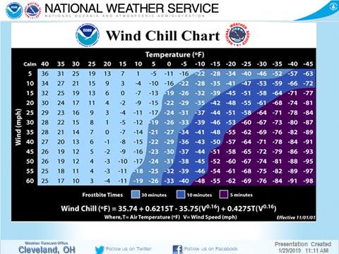
o Wind Chill: Increased wind speeds accelerate heat loss from exposed skin, and the wind
chill is a measure of this effect. No specific rule exists for determining when wind chill
becomes dangerous. As a general rule, the threshold for potentially dangerous wind
chill conditions is about -20 degrees F.
Flooding: Any high flow, overflow, or inundation by water which causes or threatens damage.
Fog: (abbreviated “F”) is water droplets suspended in the air at the Earth’s surface. Fog is often
hazardous when visibility is reduced to a ¼ mile or less.
PUBLIC MASS NOTIFICATION SYSTEMS
The Wood County EMA recognized the diverse communities and needs of our residents, those who work
in Wood County and our visitors. With the various needs of our community, there is no one size fits all
method to notify everyone in a weather event. It is the philosophy of the Wood County EMA to
promote education to our community to help our residents identify the notification platform(s) that
work best for their situation.
Notification systems are the first link in the chain for residents to protect themselves and families. After
receiving a notice from a notification system, the public must be able to identify the proper source to
get accurate information on how to respond.
CodeRED (ONSOLVE)
The CodeRED (subsidiary of ONSOLVE) County Notification System is an automated notification system
Wood County will use to call phone numbers registered with a recorded voice message. CodeRED can
reach residents, businesses, those who work in Wood County and/or anyone who registers by
residential phone, business phone or cell phone. It will make three attempts to contact each identified
phone number, will leave messages in voicemail and on answering machines.
The Wood County Commissioners maintain the agreement with CodeRED for all of Wood County. Many
local communities have elected to pay to have access to CodeRED, and to have the capability to send
messages specific to their community. Weather alerts will be sent to all registered phones in the
CodeRED System regardless if the local community they are in elected to participate.
CodeRED receives automatic notifications from NWS when a tornado warning is issued for Wood
County. Locations in the NWS polygon of the projected impacted areas will be notified automatically.
Wood County Departments as well as participating communities can also send weather related and
emergency notifications to specific identified potential impacted areas.
8|PageCitizens, businesses and those individuals who frequent Wood County are urged to register for CodeRED
through various websites, Wood County Commissioners, Wood County EMA, Northwest Water and
Sewer District or CodeRED https://public.coderedweb.com/CNE/en-US/BFB7CC4C6C0AA . Registration
can also be performed through the CodeRED cell phone app which you can find at your cell phone app
store.
Outdoor Warning Sirens:
Outdoor warning sirens are used to alert the public who are located outside that there is an
emergency and they should take immediate action to find out what the emergency is via local
media outlets or all-hazard weather radios and the take proper protective measures.
Although the outdoor warning sirens are most commonly used to alert the public outdoors of a
tornado warning, the sirens could also be used to alert the public of a hazardous materials
incident or any other type of critical emergency that would require quick notification to the
public.
The sole purpose of outdoor warning sirens is only to provide a notice of an emergency to
people who are outside of structures. People inside of structures should not rely on outdoor
warning sirens as their primary means of being alerted to an emergency. All-hazards weather
radios are your best means of being notified indoors of an emergency especially when it comes
to severe weather events.
Outdoor warning siren activation throughout Wood County (except the City of Perrysburg) is
done through the Wood County Sheriff’s Office after notification from NWS. Based on the
location of the weather event, the appropriate county zone(s) are activated. The City of
Perrysburg has the responsibility to active outdoor warning sirens under their jurisdiction.
The community in which the outdoor siren is located is responsible for supplying a location,
electricity, routine maintenance and all other associated costs for the siren.
NOAA All Hazards Weather Radio:
National Weather Radio (NWR) is a nationwide network of radio stations broadcasting
continuous weather information directly from NWS.
NWR is an “All Hazards” radio network, making it a single source for comprehensive weather
and emergency information. In conjunction with Federal, State and Local Emergency Managers
and other public officials, NWR also broadcasts warning and post-event information for all types
of hazards-including natural (tornado, rain, snow, etc.), environmental (chemical spills), and
public safety (AMBER Alerts, 9-1-1 telephone outages).
Specific Area Message Encoding (SAME) is a six digit format allowing listeners and EAS
participants to filter NWR broadcast of warnings and emergency alerts to receive subsequent
actions only messages and information for the selected geographic area(s). Wood County SAME
number/identifier is 039173.
9|PageElectronic Weather Access
Internet websites and cell phone apps can be useful in providing additional up-to-date information to
aid in decision making for Wood County:
Internet:
National Weather Service http://www.weather.gov/cle/
NOAA/ NWS Storm Prediction Center: http://www.spc.noaa.gov
Weather Underground: https://www.wunderground.com
The Weather Channel: https://weather.com
AccuWeather: http://www.accuweather.com
Cell Phone Apps
National Weather Service
o Talkonaut (NWS Weather Chat Cleveland)
o mPING (Reporting severe weather to NWS Cleveland)
o NWS Cleveland Mobile
Television:
o WTOL 11
o WTVG 13
o WNWO 24
o Weather Channel
Third Party:
o RadarScope
o NOAAWeather
o Storm Radar
Local Media
Local media can be a valuable resource for obtaining real-time information:
WTOL Channel 11 WBSU-FM (88.1)
WTVG Channel 13 WRFV-FM (101.5)
WNWO Channel 24 WKKO-FM (99.9)
WBGU-TV Channel 27 WWWM-FM (105.5)
Wood County Emergency Management Agency
It is the goal of the Wood County EMA to maintain situational awareness for any and all events that may
impact Wood County. During normal business hours situational awareness will be maintained by the
following:
Television
o Local
o National
o Weather Channel/Radar
Radio Communications
o Portable dispatch console for countywide communication
o MARCS Radio Talkgroup: EMACONW
o Amateur Radio-SKYWARN
10 | P a g eFirst Responders:
First responders in Wood County will be encouraged to attend Skywarn Weather Spotter
Training in addition to other available weather spotting training opportunities.
The safety of first responders must be their highest priority and they should consider seeking
shelter as inclement weather approaches.
First responders will be used to verify information from NWS Weather Radar, news media, social
media or any other report of severe weather.
EMERGENCY OPERATIONS CENTER (EOC):
The EOC is a central location from which County and local governments can provide interagency
coordination and executive decision making in support of an incident response and recovery
operations.
The Wood County EOC is located at the Wood County Courthouse Office Building.
The purpose of the EOC is to provide a centralized location where public safety, government
officials, support agencies and partner agencies to coordinate planning, preparedness and
response activities.
The EOC coordinates functions by:
o Collecting, evaluating and disseminating incident information;
o Analyzing jurisdictional impacts and setting priority actions;
o Managing requests, procurement and utilization of resources.
The EOC does not perform Incident command functions or control any on-scene efforts.
EOC Activation Levels
Level Description Minimum Staffing
Requirement
3 Small incident or event EOC Manager
(Monitor) One site Public information officer
Two or more agencies involved Liaison Officer
Potential threat of: Operations Section Chief
o Flood
o Severe storm
o Escalating event
2 Moderate event EOC Manager
(Partial) Two or more sites Public Information Officer
Several agencies involved Liaison Officer
Limited evacuations Section Chiefs (as required)
Resource support required Limited activation of other
EOC staff (as required)
1 Major event EOC Manager
(Full) Multiple sites Policy Group
Regional disaster All EOC functions and
Multiple agencies involved positions (as required)
Extensive evacuations
Resource support required
11 | P a g eReporting Damage to the National Weather Service
In the event storms are severe enough to result in damage to property, an initial assessment is to be
obtained. The assessments can be made first responders, local community officials, storm spotters or
any source deemed credible. When possible, photographs of the damage should be taken to they can
be relayed to NWS Cleveland for their review. This information should to be relayed to NWS Cleveland
as soon as practical.
NWS Cleveland Communications Official Use Only Pathways:
(800)-262-9683 (Primary)
(216)-265-2372 (Alternate)
(216)-265-2380 (Alternate)
NWS Chat: https://nwschat.weather.gov/
NWS Cleveland Email: stormcle@noaa.gov
Ohio Multi-Agency Radio Communications System (MARCS) Talkgroup- NWSCLE
SEVERE WEATHER GUIDELINE
Severe weather events are natural events threatening the lives, property and quality of life issues for
those living, working and traveling through Wood County. While these events can impede mobility and
a normal routine, most often they are predicted in advance of the weather event occurring. This pre-
event notification is the optimal time for communities to prepare.
Warning for meteorological hazards may be predicted anywhere from minutes to several days prior to
severe weather occurring. Situational awareness of potential severe weather is imperative for
preparedness in the event such a condition arises. The NWS will be the primary agency for receiving
storm warnings, watches, advisories and current weather conditions in the affected area.
When monitoring for potential severe weather conditions, attention needs to be paid to the
terminology used by the NWS: Watch, Advisory and Warning. Watch: Is used when the risk of a
hazardous weather or hydrologic event has increased significantly, but its occurrence, location, and/or
timing is still uncertain. It is intended to provide enough lead time so that those who need to set their
plans in motion can do so.
Advisory: Highlights special weather conditions that are less serious than a warning. They are for events
that may cause significant inconvenience, and if caution is not extended, it could lead to situations that
may threaten life and/or property. Warning: Is issued when a hazardous weather or hydrologic event is
occurring, is imminent, or has a very high probability of occurring. A warning is used for conditions
posing a threat to life or property.
Weather Spotters/SKYWARN Activation Criteria
SKYWARN is a nationwide network of volunteers trained by the NWS to report significant weather
events. Each NWS Center trains and coordinates SKYWARN Training Programs for the coverage area.
The purpose of SKYWARN is two-fold. First, Cleveland NWS is responsible for Northern Ohio Counties
(with Wood County on the western edge) into western Pennsylvania. During large weather events, it
can be difficult to maintain situational awareness for the entire region. Secondly, accurate reports from
trained weather spotters validate and/or provide information to improve the current forecast.
12 | P a g eSKYWARN Training is typically held on an annual basis in Wood County alternating between Spring and
Fall sessions. Neighboring counties also conduct SKYWARN Training which is open to everyone.
Weather spotters should attend a training session once every three (3) years to remain current. First
responders, amateur radio operators along with anyone who is interested are encouraged.
Activation of SKYWARN Spotters is performed in several ways. First responders will follow their
organizational policies, amateur radio will activated based on a request through NWS Cleveland through
Amateur Radio Emergency Services (ARES) or can self-deploy. First responders (dispatchers) and
amateur radio operators (NET operators) will follow their policies to get information to NWS Cleveland.
Those self-deploying are encouraged to report real-time weather-related observations to NWS via
phone (800-262-9683).
Tornado
Wood County can experience severe weather anytime throughout the year. These storms can be
capable of producing strong winds and/or tornados with little or no warning. Statistically, tornados in
Wood County occur in the spring and fall. This is due to the seasonal air masses changing from colder to
warmer in the spring and warmer to colder weather in the fall. Turbulence cause by these colliding
weather masses typically produce heavy downpours, hail, lightning with high winds. It should be noted
not all of these conditions need be present to produce a tornado.
Confirmed vs. Non-Confirmed Sighting
Confirmed: Weather sighting are from persons or agencies (NWS, EMA, fire departments, police
departments, etc.) that have been trained as weather spotters and can provide the necessary
information relative to the sighting.
Non-Confirmed: Sightings primarily from the general public who are not trained but provide
partial weather information. The exception to this rule will be instances where the calling party
can explain that “there is a tornado touching the ground and they can see the damage being
done”.
Severe Weather Shelters
In a tornado and/or high wind event, flying debris is the biggest hazard causing injures to people and
damaging property. When a tornado watch is issued by NWS, those in the potential impacted areas
need to devise a plan should a tornado warning be issued. Waiting until the tornado warning is issued
can delay citizens from being properly protected from flying debris.
Depending on Ohio Building Code “Use Groups”, newer public buildings are being constructed with
tornado shelters incorporated into the structure. During a Tornado Warning, occupants should seek
shelter in the designated tornado shelter and assume the “tornado safety position” (i.e., get down on
your knees and elbows, lock fingers together behind the back of the neck).
Mobile home occupants should consider seeking shelter when a tornado watch is declared by NOAA. If
taking shelter is not possible at the time the watch is issued, mobile home residents should develop a
plan on where they will go should a warning be issued.
13 | P a g eDuring a tornado watch, anyone traveling by vehicle needs to maintain situational awareness for
changing weather conditions. Never try to drive faster than a tornado as they can change direction
quickly and lift up a vehicle projecting it into the air for great distances. Attempt to seek shelter in a
nearby building. If there is no time to get inside, consider the best option available (i.e. stay in the car,
lay flat on the seat securing yourself with the seatbelt; get out of your vehicle and lie in a ditch or low-
lying area). Be aware of the potential for flying debris and flooding.
It should be noted that many older building may have old Civil Defense signs indicating an area is
designated as a tornado shelter. These are usually found in older schools, churches, libraries and other
public buildings. Occupants should be aware many of these “designated shelters” were assigned by
previous owners/ occupants. They may not provide the anticipated protection from the storm.
When seeking shelter, the following considerations should be assessed to ensure your safety:
Go to the lowest level possible in the building.
Move to the interior of the building. (bathroom, closet, storage room, stairwell)
Stay away from doors and windows to prevent being struck by flying debris.
Get under solid objects such as a desk or heavy table.
Winter Storms
Winter storms in NW Ohio typically have an advanced warning of several days unlike summer storms.
However, the impact of winter storms can take longer to return the community back to its normal
routine. Winter storms tend to impact a larger area, the weather event (i.e. heavy snow, blizzard) last
longer and having additional concerns such as cold temperatures and blowing snow hampering
restoration activities. Disruption of transportation, closed facilities, road closures and damaged utilities
are just a few of the effects of winter storms. November through March is prime time for winter storm,
but on rare occasion they can occur as early as October and as late as April.
Impacts of winter storms can be minimized with the assistance of the public. The key to success is
educating the public how prepare prior to the weather event. Preparation by our residents and
businesses will be the cornerstone to a successful outcome. By communities being prepared, less
people will be on the roadways reducing the number of accidents, stranded drivers as well as allowing
the snow plows to clear the roads more efficiently.
The NWS has identified winter storms as “deceptive killers” because most deaths and injures are
indirectly related to the storm. Vehicle accidents due to ice and snow are the number one concern,
followed by heart attacks shoveling snow and exposure related injuries such as frostbite.
Carbon monoxide is a byproduct of fossil fuel (petroleum/gasoline) powered appliances. Using portable
generators, kerosene heaters inside or even close proximity to a home can be disastrous. Anytime these
fuel powered appliances are used they need to be at least 20 feet away from any building. Furnace
vents can be blocked by snow can cause carbon monoxide to back up in the building.
14 | P a g eIce Jams/River Flooding
It is not uncommon for ice jams in Wood County on both the Maumee and Portage Rivers. Ice jams can
occur either during the formation of ice on flowing rivers and during the thawing phase as the ice begins
to break free.
Historically, ice jams will form in the same location as previous ice jams. They will be points in the
river that restrict the water flow such as narrowing banks, bends, islands, bridges and natural
curvatures.
Wood County Sheriff’s Office Snow Levels (From Wood County Sheriff’s Website)
LEVEL 1- SNOW ALERT: Roadways are hazardous with blowing and drifting snow. Roads may
also be icy. Drive very cautiously.
LEVEL 2- SNOW ADVISORY: Roadways are hazardous with blowing and drifting snow and/or icy
condition. Only those who feel it is necessary to drive should be out on the roadways. Contact
your employer to see if you should report to work.
LEVEL 3-SNOW EMERGENCY: All Municipal, Township, County State and US Routes in Wood
County are closed to non-emergency personnel. No one should be out during these conditions.
Those traveling on the roadways may subject themselves to arrest. All employee should contact
their employer to see if they should report to work as only employees designated by their
employer as essential may go to work and only if their route is passible.
For anyone who is considered emergency and/or essential personnel, they are encouraged to
seek additional information of road conditions. Ohio Department of Transportation
http://wwwohgo.com can provide not only driving conditions, traffic movement as well as
traffic cameras to aid in transportation decisions. Local media as well as navigation apps such as
Waze can also provide current road conditions.
PUBLIC EDUCATION
One of the core missions in emergency management is to inform and educate those who they are
responsible for. When an emergency or event happens, it may be too late to prepare appropriately.
Historically, the citizens of Wood County look to the EMA for guidance in how they should respond.
When weather events occur in Wood County, the EMA pushes pertinent information in several ways.
Social media has been a positive way to get information to residents, those who commute to or through
Wood County.
15 | P a g e16 | P a g e
You can also read