U.K Weather Guidance for Spring & Early Summer 2012
←
→
Page content transcription
If your browser does not render page correctly, please read the page content below
Weather Consultancy Services
                Weatherweb.net

                The Weather Centre
                188 Common Road
                Wombourne
                South Staffordshire WV5 0LT
                United Kingdom

                Telephone: (01902) 895252
                office@weatherweb.net

     U.K Weather Guidance
              for
  Spring & Early Summer 2012
                         Written by
            Dr. Simon Keeling Msc, PhD, FRMetS
                  Published 6th March 2012

                             Note that this forecast is for guidance purposes only.
 Long range forecasts do change, sometimes dramatically and so therefore any actions that you take upon
receiving this forecast are entirely your own and remain your responsibility. Weather Consultancy Services
  Ltd, Weatherweb.net or any company or individual associated with the above accept no liability for any
         losses which may be incurred as a result of actions taken on using this forecast guidance.
              Your continued reading of this forecast implies your acceptance of the above.

                      © Weather Consultancy Services Ltd / Weatherweb.net 2012
NO LET UP IN DROUGHT IN SOUTH UNTIL MID-APRIL
TEMPERATURES NEAR OR JUST ABOVE NORMAL
1. OVERVIEW
• Climate forecast model forecasts produced in February 2012 are in good agreement for the
spring and early/mid summer seasons.
• Forecasts (shown in section 2 below) show good agreement in temperature during the period
from March to May being slightly above normal levels.
Click 'Buy Now' to
• Rainfall for the same period is expected to be close to normal, although the UKMO indicates
slightly above normal rainfall in western and northern Scotland from March through May.
• The UK Met Office predicts below normal rainfall throughout the months of March to July
see the full forecast
away from the northwest. This is likely exacerbate drought problems in the south.
• For the periods from April to June and from May to July most models agree that
temperatures are likely to be close to normal, although the IRI is alone in predicting
without this box
temperatures above normal for this period.
2.SUMMARY OF MODEL FORECASTS
CFS UKMO Chinese IRI
Temp Rain Temp Rain Temp Rain Temp Rain
Mar/Apr +0.5 to 100% +0 to 0.5 70-100% 0 to 100% 50-60% 100%
/May +1 100- +0.2C chance
0C (SE) 130% (NW) above
(NW) normal
Apr/May 0C 100% +0 to 0.5 70-100% 0C 100% 50-60% 100%
/Jun 100- chance
130% above
(NW) normal
May/Jun 0C 100% +0 to 0.5 70-100% 0C 100% 40-45% 100%
/Jul 100- chance
130% above
(far N) normal
© Weather Consultancy Services Ltd / Weatherweb.net 20123. CFS GUIDANCE DETAILS
March 2012
The inference for high pressure across the south of the UK bringing continued dry weather to much of
England and Wales remains through March. More northern areas are likely to see a jet stream closer
by with westerly winds bringing rain from time to time, most over northern and western Scotland.
Click 'Buy Now' to see
With the winds in the west or southwest maximum temperatures are likely to be around 1 to 2C above
average in southern parts of the country, nearer normal across the north.
the full forecast without
However, temperature may fall after 22nd with the winds changing direction. There may be overnight
frosts from the 22nd to the end of the month, although these are not expected to be severe.
this box
Soil temperatures will be rising steadily mid-month, although they may well fall at the end of the
month as temperatures fall to nearer normal values.
April 2012
The CFS model has been consistent in showing a late season outbreaks of cold air sometime from the
end of March to early April. This possibility is accepted and confidence is running around 60 to 70%
(high fro a long range forecast). The chart below shows the mean maximum temperature for the week
ending 1st April and is similar to the previous week.
© Weather Consultancy Services Ltd / Weatherweb.net 2012It may well be that some snow showers occur during this period, perhaps even at low levels for a time,
but more especially over the hills of Scotland and northern England. Overnight frosts are likely,
although there will be some sunshine by day, and it is likely to be dry for most.
Temperatures are expected to recover after the 5th to 8th April with a gradual warming through the
month.
Rainfall amounts increase from the 10th onwards and conditions are expected to be more unsettled. The
CFS has been consistent in producing more unsettled weather and nearer normal rainfall amounts for
all by mid month.
All models are hinting at a significant warming occurring during the final week of April (from 22nd).
High pressure may well build for a time to the east, bringing southerly winds and dry weather to the
south and east, perhaps temperatures above 21C? More unsettled to the west.
Click 'Buy Now' to see
The fine weather probably not lasting long with rain arriving in the west of the country, although with
warm temperatures.
May 2012 the full forecast
The CFS runs with the idea of a mainly dry opening to May with temperatures around normal.
without this box
It then reduces temperatures from the 10th onwards and brings wetter weather to all parts of the
country.
This more unsettled weather continues until the month end in the south, is this indicative of the
European monsoon setting in?
By the final week of the month temperatures are forecast to recover, although conditions stay
unsettled.
Overall the good agreement between the models here hints that forecast confidence is quite high for a
long range forecast.
Season thereafter
Summer 2012 is expected to be nothing to exceptional It could be that temperatures are generally just
above the normal for time of year with rainfall amounts just below normal in the south of the UK, but
just above normal to the north.
© Weather Consultancy Services Ltd / Weatherweb.net 20124. EUROPEAN WEATHER
High pressure is expected to proliferate across Scandinavia, Germany, Poland, Hungary, Austria and
western Russia through much of March and into the beginning of April bringing lots of dry and sunny
weather here.
Click 'Buy Now' to see
Temperatures are likely to be around normal, although overnight frosts could be moderate to severe for
the season, and soil temperatures may be slow to recover.
the full forecast without
The CFS does not break down the fine weather here until early May.
The Mediterranean, southern France, Italy and the Balkans, Greece and Turkey may well be wetter
this box
than normal. Perhaps by 150 to 200% through much of April with the jet stream extending through
these areas. Temperatures will be below normal for the time of year and soil temperatures will be
below normal too. The CFS rainfall chart for the week ending 12th May below is typical of how
conditions may pan out.
It may well be that the unsettled conditions across southern Europe, although improving, do not really
return to what one might call 'normal continental summer weather' until the middle of June, although
there will have been a steady improvement from mid-May.
July is likely to be better, becoming dry, sunny and very warm.
Overall, a late start to summer for much of southern Europe.
© Weather Consultancy Services Ltd / Weatherweb.net 20125. OTHER FACTORS WHICH MAY INFLUENCE THE WEATHER
La Nina (Pacific cooling) is forecast to be replaced by El Nino (Pacific warming) through spring and
summer 2012.
This is expected to have an impact on global conditions, tending to break down the blocking high
pressure areas experienced in previous months, and bring a more unsettled westerly flow across the
Click 'Buy Now' to see the
UK and northern Europe.
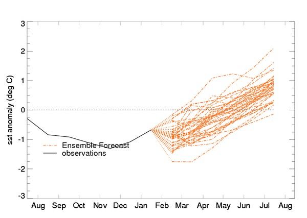
Below are the El Nino (region 3.4) forecast from the UK Met Office and CFS models. Notice how
full forecast without this box
both increase temperatures indicating that confidence is high.
El Nino forecast from the UK Met Office at
http://www.metoffice.gov.uk/research/climate/seasonal-to-decadal/gpc-outlooks/el-nino-la-nina
© Weather Consultancy Services Ltd / Weatherweb.net 2012El Nino forecast from the CFS model
http://www.cpc.ncep.noaa.gov/products/CFSv2/CFSv2seasonal.shtml
**ends***
© Weather Consultancy Services Ltd / Weatherweb.net 2012You can also read