University of Kentucky and Langara College archaeological investigations at località Coculédi, contrada Bregatorto, and in the hinterland of ...
←
→
Page content transcription
If your browser does not render page correctly, please read the page content below
The Journal of Fasti Online (ISSN 1828-3179) ● Published by the Associazione Internazionale di Archeologia Classica ● Palazzo Altemps, Via
                   Sant’Appolinare 8 – 00186 Roma ● Tel. / Fax: ++39.06.67.98.798 ● http://www.aiac.org; http://www.fastionline.org

University of Kentucky and Langara College archaeological investigations at
 località Coculédi, contrada Bregatorto, and in the hinterland of Antonimina
                        (Reggio Calabria) in 2017-2019

     G. M. Crothers - J.R. Jansson - J.E. Knapp - P.A.L. Crestani - P. Mazzaglia - P. Visonà
                                     edited by Paolo Visonà

     Due campagne di prospezioni geofisiche e saggi di scavo in località Coculédi e in contrada Bregatorto, due siti contigui ubicati
     sul margine orientale della Dorsale Tabulare tra Jonio e Tirreno, alla quota di 980 m s.l.m. e a 14 km di distanza dalla costa jonica,
     hanno accertato la presenza di un grande edificio e di una fortificazione rurale attribuibili a Locri Epizephyrii. L’edificio in località
     Coculédi, esteso su un’area di c. 600 m², venne costruito verso la fine del VI secolo e fu distrutto e abbandonato prima della
     metà del V sec. a.C.; le sue funzioni non sono ancora definibili. La fortificazione in contrada Bregatorto, coprente un’area di oltre
     1900 m², fu occupata dagli inizi del V secolo fino al III sec. a.C.; in essa si individua il principale punto di controllo del percorso di
     collegamento più diretto da Locri ai centri di Métauros e Medma sul versante tirrenico meridionale. L’identità culturale locrese di
     entrambi i siti si evince anche dall’evidenza dei rinvenimenti ceramici, che trovano stretti confronti in ambito locrese. Altri tre siti
     contigui con materiali di età greca (un probabile insediamento rurale e due posti di vedetta) sono stati identificati presso Monte
     S. Mauro, lungo il percorso in direzione di contrada Bregatorto proveniente dalla costa jonica. Questa concentrazione di siti ai
     margini della chora e l’esistenza di un sito fortificato in una posizione strategica sulla Dorsale Tabulare documentano
     un’organizzazione del territorio locrese e un sistema di controllo della viabilità interna fin dall’età tardo arcaica.

Introduction

        After three Greek sites were located within the Aspromonte National Park in the area between today’s
Passo del Mercante and Villaggio Zomaro, on the Dorsale Tabulare – a high ridge connecting the Aspromonte
Massif to the Serre highlands – geophysical surveys and test excavations were conducted in 2017 and 2018 at
località Coculédi and contrada Bregatorto, two of the sites which are in close proximity to each other and ap-
peared undisturbed (fig. 1)1. Their position on the eastern edge of the Dorsale Tabulare at a linear distance of 14
km from the Jonian coast placed them on the most direct and least strenuous overland route from Locri Epi-
zephyrii to the western coast of Italy. This route would have followed the Fiumara Portigliola and the Fiumara di
Antonimina to the Dorsale Tabulare past Monte S. Mauro (836 m) and Monte Cola (931.2 m). The remains of a
fortification at contrada Bregatorto, in particular, hinted at the importance of this route for Locri’s communica-
tions and trade with the Tyrrhenian seaboard2.

1
  See Taurianova 1998 and NANIA 2007: 167 and 257. For the third site (contrada Palazzo di Cittanova) see VISONÀ 2016a: 3-6;
VISONÀ 2016b: 248-250.
2
  WONDER, JANSSON 2018: 54-56.

                                                                                                www.fastionline.org/docs/FOLDER-it-2021-494.pdf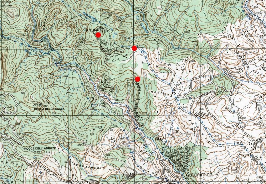
G. M. Crothers - J.R. Jansson - J.E. Knapp - P.A.L. Crestani - P. Mazzaglia - P. Visonà ● University of Kentucky and Langara College archaeological
investigations at località Coculédi, contrada Bregatorto, and in the hinterland of Antonimina (Reggio Calabria) in 2017-2019
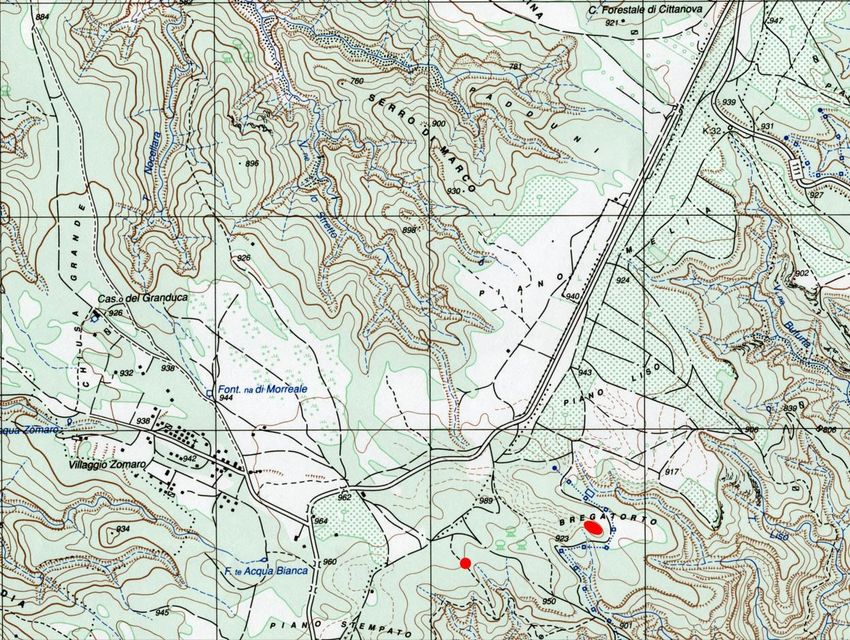
Fig. 1. Località Coculédi (left) and contrada Bregatorto (right) in Carta Topografica d’Italia Scala 1: 25000 F. 590 Sezione IV Taurianova.
Ed. 1/A. IGMI, Firenze 1998.
This project, which sought to determine the boundaries, the architectural features, and the main periods
of occupation of each site, was carried out by faculty and students of the University of Kentucky (U.S.A.) and
Langara College (British Columbia, Canada) with yearly permits granted by the Ministero dei beni e delle attivi-
tà culturali e del turismo and under the aegis of the Soprintendenza Archeologia Calabria. It was sponsored by
the Foundation for Calabrian Archaeology (Parker, Colorado, U.S.A.) and it entailed mapping, geomagnetic and
ground-penetrating radar (GPR) surveys, and targeted excavations. Fieldwalking also led to the identification of
three more Greek sites near Monte S. Mauro3, c. 2 km to the southeast of contrada Bregatorto (fig. 2), and of a
prehistoric site at Pietra della Morte (484 m), a peak c. 1 km to the southeast of the village of Tre Arie overlook-
ing the Fiumara di S. Paolo and the Fiumara Gerace, in the lower Antonimina Valley. These previously un-
known Greek sites are clustered together on the route leading to Bregatorto.
Paolo Visonà
The mapping and geophysical surveys at località Coculédi and contrada Bregatorto
In 2017 a preliminary survey of località Coculédi and contrada Bregatorto using a Trimble Juno SB GPS
receiver and a Total Station Pentax MD made it possible to understand the topography and to produce reliable
maps of both sites4. As a precursor to excavation, two complementary geophysical survey techniques, magne-
tometry and GPR, were employed to identify buried archaeological features. Since magnetometry measures
m
3
See Platì 1992 and (for preliminary data) VISONÀ 2019: 124, n. 28; 125, n. 30.
4
The topographical survey was conducted by E. Sapienza, P. Mazzaglia, and G.M. Crothers.
2
www.fastionline.org/docs/FOLDER-it-2021-494.pdf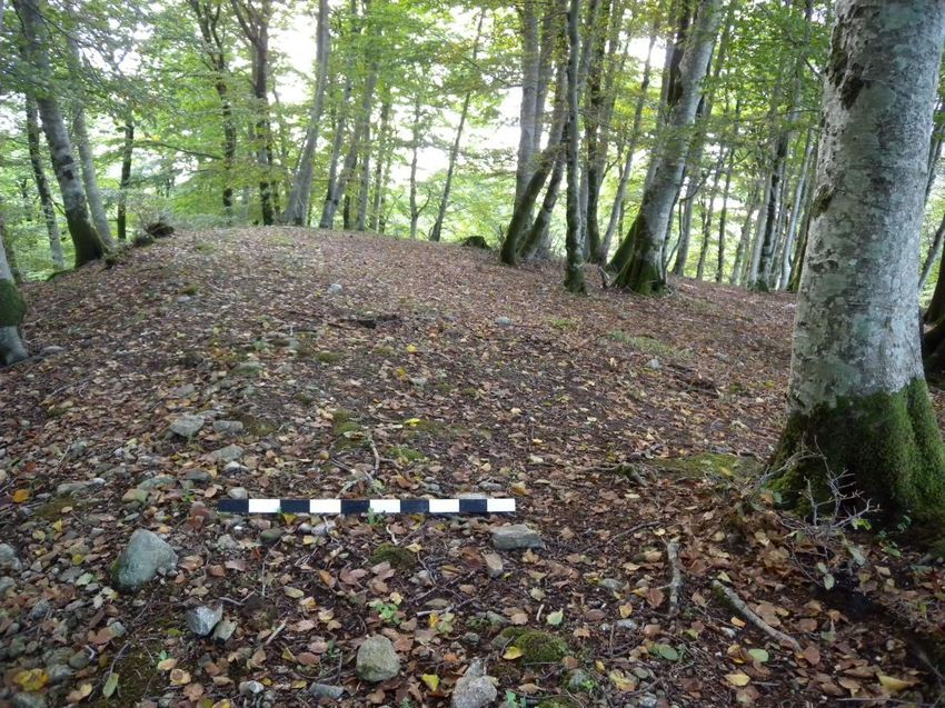
G. M. Crothers - J.R. Jansson - J.E. Knapp - P.A.L. Crestani - P. Mazzaglia - P. Visonà ● University of Kentucky and Langara College archaeological
investigations at località Coculédi, contrada Bregatorto, and in the hinterland of Antonimina (Reggio Calabria) in 2017-2019

     Fig. 2. Location of Greek sites at contrada Rampino in Carta Topografica d’Italia Scala 1: 25000 F. 590 Sezione III Platì. Ed. 1. IGMI,
                                                              Firenze 1992.

magnetic properties, while GPR is primarily sensitive to electrical properties of the subsurface, combining these
methods covers the broadest range of feature types found at archaeological sites5. The presence of large beech
trees, tree stumps, small shrubs, and the rocky terrain, were the primary obstacles to collecting continuous, high
quality data.
       A single Geoscan FM256 fluxgate gradiometer was used for the magnetometer surveys. After staking out
20 x 20 m grid units at each site, data was collected using the parallel traverse mode at 50 cm intervals. The
sample interval of each traverse was 25 cm (4 readings per meter) with a range of 200 nT and resolution of 0.1
nT. Five complete or partial grids were collected at località Coculédi, covering approximately 1660 m2, and
eleven grids at contrada Bregatorto, covering approximately 3800 m2. The gradiometer data was processed
with Geoplot (Ver. 3.00t), companion software for Geoscan instruments. The 2017 GPR survey was conducted
with a Malå Ramac CUII GeoSystem with a 500 MHz shielded antenna and a time window of 97.9 ns; in2018, a
800 MHz shielded antenna with a time window of 79.3 ns was used for a GPR survey focusing on the interior
portion of the fortification at contrada Bregatorto and the eastern edge of the site where there appeared to be
an exterior structure. The 2017 radar profiles were collected in 50 cm transects in a zig-zag fashion, oriented
grid north-south, and covering the same area as the magnetometer survey. The 2018 GPR data was collected
in 25 cm transects using the parallel traverse mode covering approximately 1825 m² of the site. The GPR data
was processed with GPR-Slice (Ver. 7.0) imaging software to produce amplitude slice maps.
       Fig. 3 shows the gradiometer images of località Coculédi and contrada Bregatorto superimposed on the
local topography and modern landscape features.

5
    CONYERS 2017. For a case study combining different geophysical techniques see CAPOZZOLI et al. 2020.

                                                                        3
                                                                                                 www.fastionline.org/docs/FOLDER-it-2021-494.pdf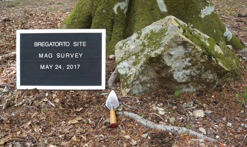
G. M. Crothers - J.R. Jansson - J.E. Knapp - P.A.L. Crestani - P. Mazzaglia - P. Visonà ● University of Kentucky and Langara College archaeological
investigations at località Coculédi, contrada Bregatorto, and in the hinterland of Antonimina (Reggio Calabria) in 2017-2019

                   Fig. 3. Position of località Coculédi and contrada Bregatorto on Antonimina’s Carta Tecnica Regionale.

Località Coculédi

       The results of the magnetometer survey at località Coculédi are illustrated by fig. 4, annotated with an in-
terpretation of various features as determined by the excavations described below6. Although the GPR survey
produced similar results, they are less evident; the interpretations presented here will refer only to the gradiom-
eter image. Two types of anomalies are especially noteworthy in this image. First, several parallel, linear fea-
tures with high magnetic readings can be seen oriented southeast to northwest and, orthogonally to that,
southwest to northeast. High positive anomalies are typically produced by magnetically enriched iron oxides,
which form in organic topsoil that becomes concentrated in ditches or pit-like features. Second, extreme dipolar
anomalies (high positive readings paired with low negative readings) are typically caused by ferrous metal, fired
brick or tile, hearths, or possibly concentrations of iron-rich rocks. In 2017, Test Units (=TU) 1, 2, and 4 were
positioned to investigate the linear magnetic anomalies on the western edge; TU3 examined the dipolar anoma-
ly on the northern edge of the site. Building upon the results of these first excavations, which identified the pe-
rimeter wall of a masonry building, TU7, TU7a, TU8, and TU9 were excavated in 2018 to further define the ar-
chitectural characteristics of this structure7.
       In the gradiometer image, the largest linear feature on the western and northern edge of the plot corre-
sponds to the natural drainage pattern of the large tableland to the west of the site, which forms the head of the
steep ravines to the east and south (fig. 3). This drainage feature is identified as f1 in fig. 4 and demarcated
with arrows showing the direction of water flow; it is conspicuous on the surface and indicated by the contour
lines of the topographic map in fig. 5.
       The second linear feature, f2, was first identified in TU1 and then fully exposed in the southern profile of
this test unit and of its westward extension, TU9 (fig. 9). It is a broad ditch, 2.5 m wide at its deepest extent (75
cm

6
    This supersedes the image illustrated in VISONÀ 2019: 129, Fig. 7 and CROTHERS 2020: 281, Fig. 4.
7
    CROTHERS 2020: 281-282.

                                                                        4
                                                                                                 www.fastionline.org/docs/FOLDER-it-2021-494.pdf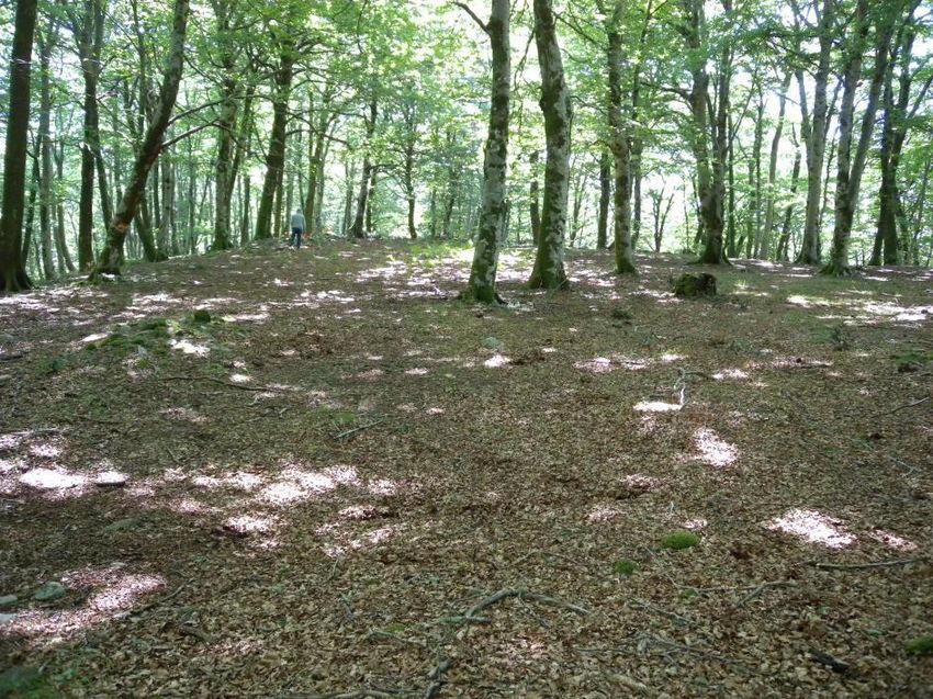
G. M. Crothers - J.R. Jansson - J.E. Knapp - P.A.L. Crestani - P. Mazzaglia - P. Visonà ● University of Kentucky and Langara College archaeological
investigations at località Coculédi, contrada Bregatorto, and in the hinterland of Antonimina (Reggio Calabria) in 2017-2019

  Fig. 4. Gradiometric map of località Coculédi, showing the anomalies f1-f4, the test units TU1- TU3 and TU4-TU9 excavated in 2017-2018,
                       and the estimated dimensions of the Greek building. Mapping and visualization by G.M. Crothers.

    Fig. 5. Topographic map of località Coculédi (scale 1: 200) showing the test units TU1-TU3, and TU4-TU9 excavated in 2017-2018, the
                      overall dimensions of the building and the filter drain. Mapping and visualization by G.M. Crothers.

                                                                        5
                                                                                                 www.fastionline.org/docs/FOLDER-it-2021-494.pdf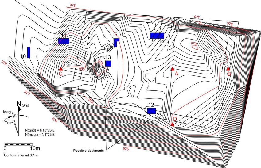
G. M. Crothers - J.R. Jansson - J.E. Knapp - P.A.L. Crestani - P. Mazzaglia - P. Visonà ● University of Kentucky and Langara College archaeological
investigations at località Coculédi, contrada Bregatorto, and in the hinterland of Antonimina (Reggio Calabria) in 2017-2019

cm below ground surface), filled with cobbles, cut pieces of granite, and roof tile fragments. This feature is in-
terpreted as a filter drain purposefully constructed on the western and possibly the northern edges of the build-
ing, parallel to and intermediary between the natural runoff (identified as feature f1) and the structure. Although
the filter drain is most distinct along the western wall of the structure in the gradiometer image, a weaker anom-
aly in fig. 4 indicates that it may also be preserved along the northern wall.
        Linear feature f3, located along the outer edge of western exterior wall, could be the remnants of a foun-
dation trench or, less likely, a concentration of roof tile fallen outside this wall. However, this feature was not in-
vestigated further.
        Two exterior walls of the structure were uncovered in TU2, TU4, TU7, and with the sondages TU7a, and
TU8. The interior face of the western wall of the building, TU2007, was first identified in TU2 and TU4 (fig. 10 a-
b). An extension of both units to the west (TU8) showed that this wall is approximately 2 m in width. After the
excavation of TU7 revealed the exterior face of the southern wall, TU7004 (fig. 14), triangulating from the edge
of the southern and western walls pinpointed the southwestern corner of the structure, which was exposed with
the sondage TU7a. Fig. 4 shows that, while the southern and western walls of the buildings are well defined,
the northern and eastern walls remain hypothetical. Headward erosion of the ravine may have caused the partial
collapse or the loss of the eastern wall.
        Test Unit TU3 was positioned to investigate the large dipolar anomaly on the northern edge of the struc-
ture, which initially was believed to be a well-preserved architectural feature. However, this anomaly appears to
result from a concentration of buried roof tile fragments. TU3 was excavated to a depth of 35 to 40 cm below
surface and yielded 10.7 kg of tile, most of which came from the northern half of the unit. It is possible that the
concentration of tile may indicate the edge of the presumed filter drain on the north side of the structure (feature
f2). There was not sufficient time to extend this trench in either direction to confirm presence of the drain or lo-
cate the edge of the northern wall of the building.
        Feature f4 (identified in fig. 4) also appears to be associated with a concentration of tile, since TU2, the
test unit that intersected it, contained 65.2 kg of tile, 95 % of which came from the eastern half of this trench. In
this case, the depth at which the tile is buried may explain why the dipolar response of the anomaly is muted.
Significantly, TU7 – a test unit associated with a strong dipolar anomaly, which was excavated in 2018 to locate
the southern wall of the building – also contained a large quantity of tile (24.2 kg) that was concentrated along
the southern edge of the unit.
        These geophysical data, integrated by the results of targeted excavations, show that località Coculédi
contains a substantial structure with a stone foundation c. 2 m wide at the base, whose western and southern
walls have been identified. Although the northern and eastern walls remain hypothetical, the structure may
have measured 20.9 x 28.7 m with an exterior footprint of c. 600 m2. A filter drain was constructed on the west-
ern and possibly the northern edges of the structure to prevent moisture from weakening its foundations. The
total footprint of the site (including the filter drain) is approximately 860 m2. This rectangular structure is orient-
ed from the northwest to the southeast on the long axis and is situated at a distance of c. 500 m from the site at
contrada Bregatorto, which lies at nearly the same elevation (fig. 3).
                                                                                                   George M. Crothers

The excavations at località Coculédi

       The Greek site identified in 2014 at località Coculédi, a tableland of Pliocenic origin situated between Pi-
ano Melìa and Piano Stempato8, occupies a low hill jutting out on the eastern edges of the Dorsale Tabulare at
the elevation of c. 980 m above sea level (fig. 6). Twelve chert and sandstone flakes and core fragments9 and a
rim with Stentinello-style impressed decoration collected in the vicinity of the site attest to the movement of
people across this locale in the late Neolithic (fig. 7)10. Other surface finds of undatable pottery from nearby Pi-
an

8
  See Carta Geologica d’Italia, Foglio 590. There is no mention of the name Coculédi in VALENTE 1973, ROHLFS 1982, or PENSABE-
NE 1987,  and in the most recent IGMI map (Taurianova 1998).
9
  Data from S. Ahler. All lithics from the 2017-2019 archaeological investigations were examined under directional light with magni-
fication between 10x and 40x using a stereozoom binocular dissecting microscope.
10
   VISONÀ 2016b: 10; VISONÀ 2020: 284, n. 20.

                                                                        6
                                                                                                 www.fastionline.org/docs/FOLDER-it-2021-494.pdf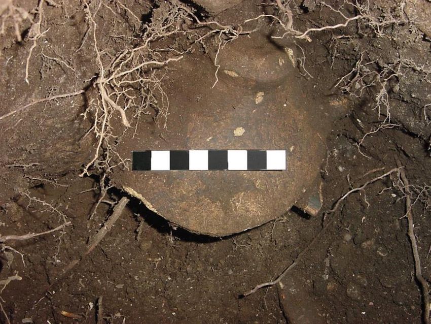
G. M. Crothers - J.R. Jansson - J.E. Knapp - P.A.L. Crestani - P. Mazzaglia - P. Visonà ● University of Kentucky and Langara College archaeological
investigations at località Coculédi, contrada Bregatorto, and in the hinterland of Antonimina (Reggio Calabria) in 2017-2019

                                 Fig. 6. The Greek site at località Coculédi, seen from the north in October, 2015.

       Fig. 7. Località Coculédi, 2017 surface find. Rim of late Neolithic vessel with impressed decoration. Dimensions: width 3.45 cm; max.
                                                 thickness 0.9 mm. From VISONÀ 2020: 284, Fig. 8.

                                                                        7
                                                                                                 www.fastionline.org/docs/FOLDER-it-2021-494.pdf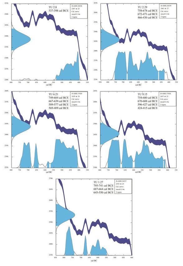
G. M. Crothers - J.R. Jansson - J.E. Knapp - P.A.L. Crestani - P. Mazzaglia - P. Visonà ● University of Kentucky and Langara College archaeological
investigations at località Coculédi, contrada Bregatorto, and in the hinterland of Antonimina (Reggio Calabria) in 2017-2019

                                                                                                   ano Liso and Piano Melìa – an area
                                                                                                   known as “Passo del Mercato” in the
                                                                                                   early 1800s11 – suggest that this
                                                                                                   ridgetop has continued to be fre-
                                                                                                   quented by travelers and traders un-
                                                                                                   til the late modern period. Since a
                                                                                                   trail coming from the Jonian coast
                                                                                                   via Monte S. Mauro and Monte Cola
                                                                                                   passed near località Coculédi12, the
                                                                                                   presence of a water source (now
                                                                                                   accessible at a lower elevation) and
                                                                                                   of a granite outcropping may have
                                                                                                   been among the reasons why this
                                                                                                   hilltop was settled by the Locrians. It
                                                                                                   seems unlikely that it was selected
 Fig. 8. Località Coculédi, 2017. The fill (context TU1003) of the filter drain in the south-      for defensive purposes, being natu-
              ern profile of the western end of trench TU1, after excavation.
                                                                                                   rally protected only by a gully to the
                                                                                                   n

     Fig. 9. Località Coculédi. Cumulative view of the southern profile of TU1 (excavated in 2017) and TU9 (excavated in 2018) showing the filter
                                                  drain and its fill. Drawing by P. Mazzaglia.

north and by a ravine on its northeastern and southeastern sides facing towards the Locrian chora, from which
no attack was expected. After the data from the geophysical survey conducted in 2017 showed that a single
structure occupied the entire area of the hill, the first test excavations targeted some of the most distinctive
magnetic anomalies, in order to discern the layout and orientation of the building and its occupational history.
Test Units, TU1, TU2 and its westward extension TU4, were focused upon three parallel anomalies in the
southwestern area of the site, while TU3 investigated an anomaly in the northern area of the site (fig. 4). The
latter unit did not produce archaeological features or narrowly datable finds.
        TU1, a 1 x 3 m trench, and its 2-m extension TU9, were excavated to the east of the anomaly corre-
sponding to a natural drainage (fig. 4, f1). In both units subsurface layers covered a thick stratum of cobbles,
pieces of granite of uniform size, and roof tile fragments, in a soil matrix that contained potsherds datable be-
tween c. 550 and 480 BCE (fig. 8; fig. 9, contexts TU1003-TU9004). The granite probably came from an out-
cro

11
   See Sezione 14, Colonna VIII of the “ricognizione eseguita dal 1821 al 1825 dagli Ufficiali dello Stato Maggiore I.R. Austriaco
sulla Gran Carta del Regno di Rizzi Zannoni”, accessible at httpps//: anticabibliotecacoriglianorossano.it/mappe-e-carte-
geografiche/carta-austriaca-del-regno-delle-due-sicilie/.
12
   A mulattiera shown in an 1879 IGMI map (Gerace, Foglio 255) and the road shown on the map of Villaggio Zòmaro 1958 follow a
similar route.
                                                                        8
                                                                                                 www.fastionline.org/docs/FOLDER-it-2021-494.pdf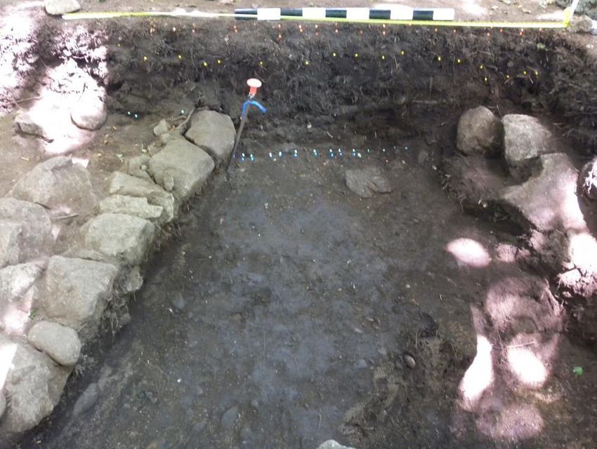
G. M. Crothers - J.R. Jansson - J.E. Knapp - P.A.L. Crestani - P. Mazzaglia - P. Visonà ● University of Kentucky and Langara College archaeological
investigations at località Coculédi, contrada Bregatorto, and in the hinterland of Antonimina (Reggio Calabria) in 2017-2019

                                                                              Fig. 10. a. Località Coculédi 2017. View of the western wall of the
                                                                            building (TU2007), seen from the north. b. Profile of the inner face of
                                                                            the western wall of the building (TU2007). Drawing by P. Mazzaglia.

cropping located less than 50 m to the southwest of the site. A cutting into the basal Pliocenic gravels (TU9009)
at the western end of TU9, which was exposed in 2018, shows that this mix of stone and tile fragments, some
of which had surface accretions, is the fill of a ditch (fig. 4, f2) that was excavated in front of the building to pre-
vent meteoric water from undermining its foundations. The ditch, interpreted as a filter drain, appears to have
followed the northern and western sides of the building, whose western perimeter wall (TU2007) was located in
TU2 and TU4. A portion of the wall’s inner face was uncovered by the excavation of these Test Units (fig. 10,
a). Preserved to a height of two courses, it was built upon a bedding of soil (fig. 10, b). Its masonry technique
consists of a revetment of roughly hewn granite blocks and cobbles enclosing a tightly packed rubble core
which resembles that of the north and south walls of the Locrian fort on Monte Palazzi13.
       In Test Unit TU2, a layer representing the phases of destruction and abandonment of the site (fig. 11,
context TU2003) covered the remnants of a roof fall (context TU2004) above a habitation layer (TU2005) that
was deposited directly upon the basal gravels (TU2006). These gravels seemingly provided the earliest surface
or piano di calpestìo inside the building. The small quantity of broken tile found in the roof collapse (which also
yielded a fragmented iron implement)14 suggests that most of the destruction debris was robbed out. The habi-
tation layer or floor fill contained pottery datable from the mid-6th to the early 5th centuries BCE, including the
overturned toe of a Corinthian style amphora (fig. 12) and fragments of different fineware vessels that may
have been used in a votive context. As the most recent pottery associated with and overlying the roof fall can
be dated to the early 5th century, the building probably was constructed towards 500 BCE and appears to have
been used for a short period of time. The causes of its destruction are unknown.
       In 2018, Test Units TU6 and TU7 were aimed at identifying the building’s southern perimeter wall while
TU9 explore the area outside the building to the west of TU1; two small sondages (TU 7a and TU8) also deter-
mined the width of the western perimeter wall to be at least 2 m and exposed the foundations of the building’s
so

13
     VISONÀ 2016b: 221-224, 236, 238-239, Figs. 29-30.
14
     This implement may have been a sickle or a pruning hook: see VISONÀ 2019: 130, Fig. 8; VISONÀ 2020: 287, Fig. 12.

                                                                        9
                                                                                                 www.fastionline.org/docs/FOLDER-it-2021-494.pdf
G. M. Crothers - J.R. Jansson - J.E. Knapp - P.A.L. Crestani - P. Mazzaglia - P. Visonà ● University of Kentucky and Langara College archaeological
investigations at località Coculédi, contrada Bregatorto, and in the hinterland of Antonimina (Reggio Calabria) in 2017-2019

                              Fig. 11. Località Coculédi 2017. Northern profile of trench TU2. Drawing by P. Mazzaglia.

         Fig. 12. Località Coculédi 2017. Overturned Corinthian-style amphora toe covering the rim of a band cup (550-500 BCE) in context
                                               TU4004. From VISONÀ 2020: 288-289, Fig. 16.

southwestern corner. In TU6, a 2 x 4 m trench, a layer of charcoaly soil located in the southern half of the
trench at a depth of c. 40 cm overlay a concentration of head-size cobbles above sterile soil (fig. 13). This lens
of burnt soil extends into the eastern baulk and may represent a hearth that was used briefly, since it did not
leave a strong magnetic signature. Most of the cookingware from TU6 came from the southern half of the
trench and was associated with this feature. In contrast, fragments of vessels related to food preparation and
storage were recovered from the northern half of the trench, where a single cut block of granite found in situ
may have been used as a stand. It is uncertain whether this area of the building was roofed over, given that on-
ly a small quantity of tile fragments was found in the northwestern corner of the trench. As in TU2, all the ce-
ramic fragments from this Test Unit are also datable between the late 6th and the ealy 5th centuries BCE. The
an

                                                                        10
                                                                                                 www.fastionline.org/docs/FOLDER-it-2021-494.pdf
G. M. Crothers - J.R. Jansson - J.E. Knapp - P.A.L. Crestani - P. Mazzaglia - P. Visonà ● University of Kentucky and Langara College archaeological
investigations at località Coculédi, contrada Bregatorto, and in the hinterland of Antonimina (Reggio Calabria) in 2017-2019
Fig. 13. Località Coculédi 2018. Detail of the eastern half of TU6, showing a cut granite block in situ at the northern end and a concentra-tion
of cobbles covered by burnt soil at the southern end of the trench.
analysis of two samples of charcoal from TU2 and a sample of charcoal from the area of burnt soil has yielded
calibrated (with 2σ error) calendar radiocarbon dates (rounded to the nearest 10 years) ranging between 540-
400 BCE, 760-430 BCE, and 750-410 BCE, and two samples of charcoal from TU1 and TU9 have produced
calibrated calendar dates ranging between 800-550 BCE and 750-420 BCE, respectively (Table A)15. These
consistent sets of data corroborate the possibility that the building went out of use in the 5th century, even
though less than 3% of the total area of the site has been excavated thus far.
The excavation of TU7, a 2 x 2 m trench opened on the brow of the hill, 5 m to the south of TU6, uncov-
ered the outer face of the southern perimeter wall (fig. 14, TU7004), whose extant courses were built directly
upon the gravelly marine deposit. Stacked layers of tile fragments found in the southern area of this trench are
probably related to the collapse of the roof of the building. Exposing a segment of the southern wall also al-
lowed locating the foundations of the building’s southwestern corner, which consist of two rows of granite boul-
ders (fig. 15). As a result, two exterior walls of this structure have been identified. However, its functions remain
enigmatic. There is no compelling evidence at present that this building was used as a frontier sanctuary, as
has been suggested16, although this could yet be determined by future investigations, since less than 3 % of
the structure has been systematically explored to date. An example of ritual activity documented in TU4 and a
base of a miniature kotyle from a recent soil layer in TU7 outside the southern wall of the building have parallels
at Monte Palazzi17.
Finds of fragments of glazed pottery found in surface layers in TU2 and TU4, a 20 centesimi nickel coin
of the Kingdom of Italy minted between 1918 and 1920, and lead shot, show that the site has been visited in
recent years.
Paolo Visonà
15
All radiocarbon analyses were performed by DirectAMS Radiocarbon Dating Service, Bothell, WA, USA. Calibrations with CALIB
Radiocarbon Calibration Program, REIMER et al. 2013.
16
Cf. VISONÀ 2016b: 251; SUDANO 2018: 127; SUDANO 2019; DE SENSI SESTITO 2020: 113.
17
VISONÀ 2016b: 225-227.
11
www.fastionline.org/docs/FOLDER-it-2021-494.pdfG. M. Crothers - J.R. Jansson - J.E. Knapp - P.A.L. Crestani - P. Mazzaglia - P. Visonà ● University of Kentucky and Langara College archaeological
investigations at località Coculédi, contrada Bregatorto, and in the hinterland of Antonimina (Reggio Calabria) in 2017-2019
Table A. Calibrated radiocarbon dates of charcoal samples from località Coculédi. Data processing and visualization by G.M. Crothers.
12
www.fastionline.org/docs/FOLDER-it-2021-494.pdfG. M. Crothers - J.R. Jansson - J.E. Knapp - P.A.L. Crestani - P. Mazzaglia - P. Visonà ● University of Kentucky and Langara College archaeological
investigations at località Coculédi, contrada Bregatorto, and in the hinterland of Antonimina (Reggio Calabria) in 2017-2019
Fig. 14. Località Coculédi 2018. Eastern profile of trench TU7. Drawing by P. Mazzaglia.
Fig. 15. Località Coculédi 2018. The foundations of the southwestern corner of the building. Drawing by P. Mazzaglia.
The ceramic finds from località Coculédi
A larger quantity of pottery was found in 2017 at località Coculédi, where four trenches were excavated,
while only one trench could be opened at contrada Bregatorto. In contrast, since more and larger test units
were excavated at Bregatorto in 2018, less ceramic material was expected from Coculédi than in the previous
campaign.
The pottery found at località Coculédi is consistently dated from the mid-6th century BCE through the
early 5th century BCE and comprises a large proportion of body sherds. In the second field season fineware
accounted for an increased proportion of the total count (38 % in 2018 vs. 15% in 2017) and weight (24% in
201820
13
www.fastionline.org/docs/FOLDER-it-2021-494.pdfG. M. Crothers - J.R. Jansson - J.E. Knapp - P.A.L. Crestani - P. Mazzaglia - P. Visonà ● University of Kentucky and Langara College archaeological
investigations at località Coculédi, contrada Bregatorto, and in the hinterland of Antonimina (Reggio Calabria) in 2017-2019
2018 vs. 12% in 2017); all other wares accounted for a lower percentage of the total quantity of pottery than
they did in 2017 (fig. 16). Common and cookingwares are most common; amphorae and coarseware vessels
are rare. Fabrics for all wares are local in nature and similar to those found at nearby sites, such as Monte
Palazzi, Locri, and Kaulonia.
Fig. 16. Sherd count and weight from the 2017 and 2018 excavations at località Coculédi.
Among the earliest datable fragments of pottery from TU1 is the partial base of an Ionic cup B2 dating to
550-500 BCE. This base came from a debris layer representing the collapse of the western wall of the building
(fig. 9, context TU1004), which overlay a fill (contexts TU1003–TU9004) that contained mostly commonware
body sherds (probably from storage and functional kitchen vessels, such as jugs and jars), and some fineware
fragments datable to the early 5th century BCE.
A larger quantity of datable sherds was found in a destruction and abandonment layer excavated in TU2
(fig. 11, context TU2003). These forms, primarily cookingware, date to ranges overlapping in the early 5th
century BCE, and are consistent with those found in TU1. The commonware includes a mortarium rim likely
dating from the mid-6th to the early 5th centuries; another mortarium rim comes from baulk trim (fig. 17, a-b)18.
The pottery from the remnants of a roof collapse in TU2 (fig. 11, context TU2004) is datable to this horizon. A
habitation layer beneath the roof fall also yielded ceramic fragments datable to the early 5th century BCE,
com
18
KNAPP 2020: 301-302, nos. 17-18.
14
www.fastionline.org/docs/FOLDER-it-2021-494.pdfG. M. Crothers - J.R. Jansson - J.E. Knapp - P.A.L. Crestani - P. Mazzaglia - P. Visonà ● University of Kentucky and Langara College archaeological
investigations at località Coculédi, contrada Bregatorto, and in the hinterland of Antonimina (Reggio Calabria) in 2017-2019
Fig. 17. Commonware and transport amphorae found at località Coculédi in 2017. a. mortarium rim, mid-5th through 5th centuries BCE; b.
mortarium rim, 5th century BCE; c. toe of Corinthian A or B (or related) amphora, late 6th to early 5th centuries BCE; d. neck and orlo a
cuscinetto rigonfio of Locrian A3 amphora, c. 50-450 BCE. From KNAPP 2020: 302, Fig. 29.
comprising mainly commonware, with one concentration of fineware and one of cookingware, including a di-
stinctive type of chytra (fig. 18, a)19. This context yielded several partially reconstructable vessels, including
early 5th century BCE skyphoid cups20 and a Locrian transport amphora with orlo a cuscinetto rigonfio A3,
datable between 500-450 BCE (fig. 17, d)21.
Several fineware vessels datable to the second half of the 6th century BCE and the early 5th century BCE
came from TU4, an extension of trench TU2. The earliest cultural layer above sterile soil in TU4 (context
TU4004) contained an apparently intentionally overturned toe of a Corinthian A or B (or related) amphora
datable to the late 6th to early 5th centuries BCE (fig. 17, c)22 that covered fragments of a band cup (fig. 19, b)23.
Considering the types of vessels found in this layer, which include fragments of an Ionian B2 cup (fig. 19, a), a
kylix, and skyphoid cups, their relative completeness, and the overturned amphora, this context could be votive
in nature. The small, likely intentional, hole in the lower wall of a skyphoid cup from this layer (fig. 19, c) 24, is
additional evidence of a votive function.
Within TU6, which produced the largest quantity of ceramic fragments of all the test units excavated at
località Coculédi in 2018, the pottery also dates consistently to the late 6th or early 5th centuries BCE. It was
concentrated especially in the cultural layers overlying a burnt area in the southeastern end of this trench and
adjacent to a cut block in the northeastern corner (see above, fig. 13). A relatively even proportion of fine-,
cooking-, and commonwares used for dining, cooking, and food preparation and service, suggests that the area
of the building in which this trench was placed had domestic functions. Vessels associated with food prepara-
tio
19
KNAPP 2020: 299, no. 10.
20
Similar to Locrian skyphoid cups type A6, 500-480 BCE: KNAPP 2020: 298, no. 4.
21
BARRA BAGNASCO 1992a: 231, no. 183; KNAPP 2020: 301, no. 20.
22
KNAPP 2020: 301, no. 19. For amphora toes buried upside down in votive deposits at Motya in the Archaic period see ISSERLIN,
DU PLAT-TAYLOR 1974: 77-78.
23
KNAPP, CRESTANI 2020: 293; KNAPP 2020: 297, no. 1.
24
KNAPP 2020: 298, no. 6, Fig. 26e.
15
www.fastionline.org/docs/FOLDER-it-2021-494.pdfG. M. Crothers - J.R. Jansson - J.E. Knapp - P.A.L. Crestani - P. Mazzaglia - P. Visonà ● University of Kentucky and Langara College archaeological
investigations at località Coculédi, contrada Bregatorto, and in the hinterland of Antonimina (Reggio Calabria) in 2017-2019
Fig. 18. Cooking and commonware vessels found in 2017 and 2018: a. chytra, rim, 6th to 5th centuries BCE; b: frying pan, handle, 4th to 3rd
centuries BCE; c. juglet, rim, 5th to 3rd centuries BCE; d. table amphora, rim, mid-5th century BCE; e. basin, rim, 3rd century BCE.
tion and storage, including a mortarium rim similar to that from layer TU200325, a single amphora sherd, and
commonware sherds with heavy interior ribbing (likely from storage jars) came from the northern end of TU6,
while the vast majority of the cookingware found in 2018 came from the southern half of the trench, possibly at-
testing to a different activity area.
In contrast, the ceramics found in TU7, a small test unit in which a segment of the southern perimeter
wall and a small area outside the building were uncovered, consisted primarily of body sherds with a high pro-
portion of fineware, mostly identified as late 6th and early 5th century BCE cups (primarily Ionic B2 cups, sky-
phoid cups, kylikes, and skyphoi). Nearly all of them came from a subsurface layer that also contained the base
of a miniature kotyle similar to a Locrian form of the second half of the 6th century BCE (fig. 19, d)26. Although
this type of vessel was generally used for ritual purposes, it was not found in a stratigraphically relevant con-
tex
25
See above, footnote 18.
26
RUBINICH 1992: 89 and 96-97, ‘kotyle a fasce’, no. 12, tav. XLIV.
16
www.fastionline.org/docs/FOLDER-it-2021-494.pdfG. M. Crothers - J.R. Jansson - J.E. Knapp - P.A.L. Crestani - P. Mazzaglia - P. Visonà ● University of Kentucky and Langara College archaeological
investigations at località Coculédi, contrada Bregatorto, and in the hinterland of Antonimina (Reggio Calabria) in 2017-2019
Fig. 19. Fineware vessels found at località Coculédi and contrada Bregatorto in 2017 and 2018. a. Ionic cup B2, base, 550-500 BCE; b. band
cup, rim, 550-500 BCE; c. skyphoid cup rim with intentional hole, 500-480 BCE; d. miniature kotyle, base, 550-500 BCE; e. banded skyphoid
cup, rim, 550-480 BCE.
text. A small quantity of pottery was also found with the remnants of a roof fall and in the soil underneath it, but
none of it was datable.
Overall, the pottery from località Coculédi supports the possibility that this site was occupied for a short
period of time from the late Archaic to the early Classical periods. However, in view of the scant amount of ce-
ramic material found thus far, any quantitative analysis must be approached with caution and conclusions con-
sidered tentative.
Jennifer E. Knapp and Paolo A.L. Crestani
Contrada Bregatorto
The hypothesized layout of the fortification walls superimposed on figs. 20 and 21, which illustrate the
main results of the geophysical surveys conducted at contrada Bregatorto, is a combination of the gradiometric
and GPR data, local topography, and exposure of rock on the surface. As at the Coculédi site, large dipolar lin-
ear anomalies in the gradiometer image (fig. 20)27 were presumed to be either concentrations of roof tile or
re
27
This supersedes the image illustrated in VISONÀ 2019: 125, Fig. 3 and CROTHERS 2020: 283, Fig. 6.
17
www.fastionline.org/docs/FOLDER-it-2021-494.pdfG. M. Crothers - J.R. Jansson - J.E. Knapp - P.A.L. Crestani - P. Mazzaglia - P. Visonà ● University of Kentucky and Langara College archaeological
investigations at località Coculédi, contrada Bregatorto, and in the hinterland of Antonimina (Reggio Calabria) in 2017-2019
Fig.20. Gradiometric map of contrada Bregatorto showing the test units TU5, TU10-TU14 excavated in 2017-2018. Data processing and
visualization by G.M. Crothers.
Fig. 21. GPR amplitude slice of the fortification at contrada Bregatorto from c. 69 to 103 cm below surface with tentative diagram of the
perimeter walls, interior features, and presumed observation tower in the northeastern corner of the complex. Data processing and visualiza-
tion by G.M. Crothers.
remnants of stone walls. A linear anomaly corresponding to a wall line was particularly intense on the southern
edge, less so on the northern edge, and not evident on the western or eastern edges of the site.
An unexpected linear anomaly on the extreme western edge of the survey area runs east-west approxi-
mately in the middle of the area connecting the site to the flat ridgetop of the Dorsale. Initially believing that this
feature could be a paved trail leading to an entrance in the western wall of the fortification, Test Unit TU10 was
placed to investigate it. However, it contained a single roof tile fragment (0.16 kg) and produced no flagstones
or remnants of walls. This feature, therefore, may be relatively recent and possibly an artifact of the modern trail
which runs through the site. Foot, animal, and wheeled traffic over several decades could have compacted the
sediments and the underlying gravelly marine deposits that are near the surface, enhancing the magnetic sig-
nature of the soil.
The massive southern wall of the fort is the most visible, as is evident from the strong dipolar linear
anomaly in the gradiometer image (fig. 20) and partially in the GPR slice (fig. 21). This wall also follows very
closely the edge of the contour of the topographic map (fig. 22). At least two intense lines of rock exposed on
th
18
www.fastionline.org/docs/FOLDER-it-2021-494.pdfG. M. Crothers - J.R. Jansson - J.E. Knapp - P.A.L. Crestani - P. Mazzaglia - P. Visonà ● University of Kentucky and Langara College archaeological
investigations at località Coculédi, contrada Bregatorto, and in the hinterland of Antonimina (Reggio Calabria) in 2017-2019
Fig. 22. Topographic map of contrada Bregatorto (scale 1: 200) showing all the test units excavated in 2017-2018 and the overall dimen-
sions of the fortification. Mapping and visualization by G.M. Crothers.
the outer edge of the wall could also be abutments to buttress the wall against the steep southern slope of the
terrace. A test unit aimed at investigating this wall yielded a massive rock tumble from the collapse of the wall
matrix but relatively small quantity of roof tile (2.16 kg), suggesting that the magnetic anomaly is a signature of
the stone wall rather than the result of a concentration of roof file.
The northern wall is more conjectural; it was drawn to capture the alternating dipolar images (fig. 20) and
follows the contour of the northern edge of the terrace (fig. 22), which suggests that it was built at an oblique
angle to the other walls. Although the eastern wall was not investigated, it is marked by a line of rock partially
exposed on the surface at the eastern end of the terrace. It appears in the gradiometer as a slightly higher
magnetic linear feature and is also partly evident in the GPR image (fig. 21).
A 2 x 4 m Test Unit, TU11, was originally placed to intersect the western wall of the fortification in an ar-
ea where there was a slightly higher magnetic linear anomaly, comparable to that of the eastern wall. However,
the results of this excavation were negative, since the unit contained mainly rock tumble. A reassessment of the
geophysical data indicates that this test unit is outside of the fortification; the western wall is probably located
further to the east, as the GPR image has revealed.
The most significant data for defining the outline of the fort came from TU14, a 2 x 5 m trench. This unit
was aimed to test a gap in the high reflectance energy along the edge of the northern wall which was suspect-
ed to be the location for a gateway (fig. 21). Like TU12, TU14 contained massive rock tumble, but preserved
underneath it the remnant of a wall face oriented north-south and parallel to a hard-packed surface on the
eastern side (see figs. 27-28). Even though the ends of this wall could not be fully exposed, it appears to be
nearly perpendicular to the northern wall of the fortification, thus forming a recessed entryway. Although the
eastern wall of this entryway remains conjectural, the entryway is presumed to be at least 3.75 m wide, corre-
sponding to the gap in the high reflectance values of the GPR image (fig. 21). This feature bears a strong re-
se
19
www.fastionline.org/docs/FOLDER-it-2021-494.pdfG. M. Crothers - J.R. Jansson - J.E. Knapp - P.A.L. Crestani - P. Mazzaglia - P. Visonà ● University of Kentucky and Langara College archaeological
investigations at località Coculédi, contrada Bregatorto, and in the hinterland of Antonimina (Reggio Calabria) in 2017-2019
Fig. 23. Serro di Tavola (Sant’ Eufemia d’Aspromonte). Building phases of the fortification. From BRIZZI and COSTAMAGNA 2010: 584,
Fig. 416.
semblance to the recessed entryway of the fortified site of Serro di Tavola (Sant’Eufemia di Aspromonte) in its
second architectural phase, which has been dated to the second half of the 6th century BCE (fig. 23)28. Some of
the rock fall to the east of the exposed portion of the entryway may have come from the collapse of a large
tower or bastion located in the northeastern corner of the fortification, on one of the highest points of the ter-
race.
A tentative reconstruction of the fortification at contrada Bregatorto, whose remains occupy the end of a
steeply sided terrace facing toward the Jonian coast, suggests an exterior footprint of 1928 m2 with 2.5 to 3 m
thick walls providing an interior space of slightly more than 1500 m2. Walls of similar width are characteristic of
Greek late Archaic fortifications across the Mediterranean29. Based on the intense amount of rock reflected in
the GPR, interior structures such as barracks, or storerooms may have been built along the western and possi-
bly
28
BRIZZI, COSTAMAGNA 2010: 584.
29
VISONÀ 2016a: 222, n. 16.
20
www.fastionline.org/docs/FOLDER-it-2021-494.pdfG. M. Crothers - J.R. Jansson - J.E. Knapp - P.A.L. Crestani - P. Mazzaglia - P. Visonà ● University of Kentucky and Langara College archaeological
investigations at località Coculédi, contrada Bregatorto, and in the hinterland of Antonimina (Reggio Calabria) in 2017-2019
bly the southern walls. A recessed gateway located on the northern wall appears to be paired with a potential
bastion or tower in the northeastern corner, which was one of the site’s highest points. An open courtyard may
have occupied the central area in the eastern two-thirds of the fort, where no interior structures have been de-
tected. The 800 MHz GPR survey conducted in 2018 was intended to provide higher resolution of possible inte-
rior structural foundations and the possible exterior structure at the eastern end of the fortification but has not
yet been fully processed.
George M. Crothers
The excavations at contrada Bregatorto
Located on an elongated terrace connected to the Dorsale Tabulare by an intervening slope, at an eleva-
tion of c. 980 m above sea level30, contrada Bregatorto is naturally protected by steep escarpments on three
sides and close to a permanent source of water (fig. 24). Its position dominates the final ascent to the Dorsale
by the most direct overland route linking ancient Locri to the Tyrrhenian coast. Dr. Domenico Raso of Cittanova
(1938-2013), who first reported the presence of ruins at this site in 200131, had hypothesized that they belonged
to a Locrian fortification. Remains of massive walls especially visible along the southern side of the terrace, in-
cluding large cut blocks of stone (fig. 25), and finds of fragmented bronze projectile points32, attest to the site’s
use for defensive purposes in antiquity.
Fig. 24. The Greek site at Contrada Bregatorto, seen from the west in June, 2015.
The test excavations conducted in 2017 and 2018 were based upon the geophysical data, which showed
the presence of a large enclosure occupying nearly the entire surface of the terrace (see figs. 20-22). Even
though only a small, 1 x 4 m trench (TU5), could be opened in 2017, it revealed a depositional sequence dating
from the early 5th century to the 3rd century BCE. The earliest cultural layer covered a sterile soil similar to the
pli
30
This datum supersedes the elevation mentioned in VISONÀ 2019: 124.
31
RASO 2001: 51-52, 100-101, 105; cf. VISONÀ 2016a: 6, 10-11; VISONÀ 2020: 276, n. 11.
32
Six arrow points find comparanda in BAITINGER 2001: 13-16, 25-27 and Pl. 4, no. 65, Pl. 6, nos. 154 and 160, Pl. 11, no. 403. For
two examples see VISONÀ 2019: 126, Fig. 4. Similar projectile points are known from San Salvatore and Monte Palazzi: cf.
FOXHALL, YOON 2016: 13, Fig. 5; VISONÀ 2013: 12, Fig. 33; VISONÀ 2016b: 223, Fig. 6-7 and 232, Fig. 19.
21
www.fastionline.org/docs/FOLDER-it-2021-494.pdfG. M. Crothers - J.R. Jansson - J.E. Knapp - P.A.L. Crestani - P. Mazzaglia - P. Visonà ● University of Kentucky and Langara College archaeological
investigations at località Coculédi, contrada Bregatorto, and in the hinterland of Antonimina (Reggio Calabria) in 2017-2019
Fig. 25. Località Bregatorto 2017. Cut block near the southwestern corner of the fortification.
Pliocenic gravels of località Coculédi; the most recent pottery came from a roof fall and a debris layer possibly
related to the destruction of the fortification. A radiometric analysis (with 2σ error) of two samples of charcoal
from the earliest and the latest contexts in this test unit yielded calibrated calendar dates (rounded to the near-
est 10 years) ranging between 800 and 550 BCE and 370-200 BCE (Table B).
Five additional Test Units were excavated in different areas of the site in 2018. TU10, a 1 x 4 m trench,
was placed near the western approach to the terrace to discern the nature of an anomaly detected by the gra-
diometric and GPR surveys, which had initially been interpreted as an access road or a paved ramp. Yet, the
anomaly appears to have been caused by the use of the modern trail leading to the terrace, since the excava-
tion of TU10 to a depth a c. 70 cm did not expose an ancient surface or pavement. A larger Test Unit, TU11,
was positioned to locate the western perimeter wall of the fort, which was initially believed to have stood close
to the western end of the terrace. But this 2 x 4 m trench was mostly occupied by incoherent rock tumble and
yielded a few ceramic fragments datable to the early 5th century BCE. This evidence, and a reassessment of
the geophysical data, suggest that the area investigated by TU11 was outside the fortification.
A 2 x 3 m trench, TU12, targeted the southern perimeter wall. The excavation of this unit exposed debris
from the collapse of this wall in a soil matrix that contained some heavily encrusted potsherds, including the rim
of a banded skyphoid cup (550-480 BCE). Since many of the ceramic fragments from TU12 were within the
rock tumble and soil from the collapse of the wall, and are datable to the early 5th century, they provide a tenta-
tive terminus post quem of c. 500 BCE or the construction of this rampart. A stone-lined post-hole found be-
neath the rock tumble (fig. 26) may be indicative of the presence of interior structures (such as barracks or
storerooms) adjacent to the wall (cf. fig. 21) 33.
TU13, a 2 x 2 m trench, was placed to investigate a low-lying area in the western half of the terrace. In
this unit a destruction and abandonment stratum overlay the remnants of a roof fall, which covered a habitation
la
33
A radiocarbon analysis (with 1σ error) of an organic sample from the posthole (TU12.17) inexplicably yielded a calibrated date
ranging between 430 CE and 610 CE, which suggests that the sample was contaminated. The paleobotanical data from the post-
hole analyzed by Sila Motella (ARCO, Cooperativa di Ricerche Archeobiologiche, Como) show the presence of various species of
trees and plants including Fagus sylvatica, Ostrya / Carpinus, Quercus sp, Cornus sp., Erica sp., and Viburnum sp., none of which
can be identified as the wood used for the post.
22
www.fastionline.org/docs/FOLDER-it-2020-495.pdfG. M. Crothers - J.R. Jansson - J.E. Knapp - P.A.L. Crestani - P. Mazzaglia - P. Visonà ● University of Kentucky and Langara College archaeological
investigations at località Coculédi, contrada Bregatorto, and in the hinterland of Antonimina (Reggio Calabria) in 2017-2019
Table B. Calibrated radiocarbon dates of charcoal samples from contrada Bregatorto. Data processing and visualization by G.M. Crothers.
layer. Pliocenic gravels were exposed beneath the habitation layer, as at località Coculédi. The excavation of
TU13 also revealed the presence of a modern pit that extended from the southwestern corner to the southeast-
ern edges of the trench. Most of the pottery from this unit ranges in date from the 5th to the early 3rd centuries
BCE – except for two rims of ceramica a ingobbio rosso interno, which were found in the destruction and aban-
donment horizon and in the habitation layer that were cut into by the pit. These finds raise the possibility that
the site was frequented as late as the 1st century BCE. The pit may be related to an episode of stone robbing,
since TU13 is adjacent to an elevated point of the terrace that could be a recent accumulation of debris (see fig.
22). It is the first example of a recent disturbance inside the fortification that has been identified thus far. A radi-
ometric analysis (with 2σ error) of a charcoal sample from the habitation layer in TU13 yielded calibrated dates
(rounded to the nearest 10 years) between 360-160 BCE (Table B), while two charcoal samples from the
pitga
23
www.fastionline.org/docs/FOLDER-it-2020-495.pdfG. M. Crothers - J.R. Jansson - J.E. Knapp - P.A.L. Crestani - P. Mazzaglia - P. Visonà ● University of Kentucky and Langara College archaeological
investigations at località Coculédi, contrada Bregatorto, and in the hinterland of Antonimina (Reggio Calabria) in 2017-2019
Fig. 26. Contrada Bregatorto 2018. Stone-lined posthole (c. 18 x 18 cm) in trench TU12, after excavation.
pit gave calibrated dates ranging between 1670-1950 CE and 1660-1950 CE. The latter set of dates has not
been included in Table B; it is presented in Table C which includes all the raw data (with 1σ error) from both
località Coculédi and contrada Bregatorto.
Sample Code Cat. No. Measured Radiocarbon Age Calibrated Calendar Date Range
rcy BP 1σ error (rounded to nearest 10 years)
Località Coculédi
D-AMS 24337 TU 1.27 2535 25 800 BCE 550 BCE
D-AMS 24338 TU 2.8 2387 25 540 BCE 400 BCE
D-AMS 24339 TU 2.29 2461 27 760 BCE 430 BCE
D-AMS 37929 TU 6.21 2439 24 750 BCE 410 BCE
D-AMS 37930 TU 9.15 2457 25 750 BCE 420 BCE
Contrada Bregatorto
D-AMS 24340 TU 5.29 2217 28 370 BCE 200 BCE
D-AMS 24341 TU 5.30 2540 25 800 BCE 550 BCE
D-AMS 37934 TU 12.17 1515 22 430 CE 610 CE
D-AMS 37931 TU 13.19 2173 25 360 BCE 160 BCE
D-AMS 37932 TU 13.21 157 22 1670 CE 1950 CE*
D-AMS 37933 TU 13.25 184 21 1660 CE 1950 CE*
* Ranges are suspect due to impingement on the end of the calibration data set.
Table C. Radiocarbon Ages and Calibrated Calendar Age Ranges at Two Standard Deviations (95% c onfidence interval). Data processing by
G. M. Crothers34.
The largest and most productive Test Unit opened in 2018 was placed in the north-central area of the ter-
race, where an analysis of the GPR data pointed to a gap in the northern perimeter wall that suggested an en-
trance. The excavation of this 2 x 5 m trench uncovered the remnants of a retaining wall oriented north-south
that can be interpreted as one of the wings of a recessed gateway (fig. 27; cf. fig. 21). A close comparandum
for this type of entrance is provided by the fortification at Serro di Tavola, which has been attributed to Rhegion
(fig. 23)35. A beaten earth surface occupied the passageway on the eastern side of the wall (fig. 28, context
tu
34
Calibrations made with CALIB Radiocarbon Calibration Program, REIMER et al. 2013.
35
BRIZZI, COSTAMAGNA 2010: 581-582, 593.
24
www.fastionline.org/docs/FOLDER-it-2020-495.pdfG. M. Crothers - J.R. Jansson - J.E. Knapp - P.A.L. Crestani - P. Mazzaglia - P. Visonà ● University of Kentucky and Langara College archaeological
investigations at località Coculédi, contrada Bregatorto, and in the hinterland of Antonimina (Reggio Calabria) in 2017-2019
Fig. 27. Contrada Bregatorto 2018. The western wall of the gateway and the beaten earth surface in trench TU14.
Fig. 28. Contrada Bregatorto 2018. Partial northern profile of trench TU14. Drawing by P. Mazzaglia.
25
www.fastionline.org/docs/FOLDER-it-2020-495.pdfG. M. Crothers - J.R. Jansson - J.E. Knapp - P.A.L. Crestani - P. Mazzaglia - P. Visonà ● University of Kentucky and Langara College archaeological
investigations at località Coculédi, contrada Bregatorto, and in the hinterland of Antonimina (Reggio Calabria) in 2017-2019
TU14010), whose estimated width exceeds 3.5 m. This seems to eliminate the possibility that this entrance is a
postern gate36. The beaten earth surface was under a massive tumble of rocks and boulders that is presumed
to have come from the destruction of the opposite wing of the gateway and the collapse of a bastion or a tower
that rose to the east of the gateway. Both the large quantity of rock on the ground and the high amplitude re-
flection shown by the GPR in the northeastern area of the fortification are consistent with the possible presence
of a tower. An observation tower in this corner would have had several important functions: in addition to pro-
tecting the entrance to the fort, it would have kept under surveillance the surrounding landscape and could
have been used to send fire and smoke signals to the Locrian chora. Two parallel features protruding from the
eastern perimeter wall, which were detected by the GPR, are unlikely to belong to a tower, as has been sug-
gested earlier37; they may belong to an exterior structure attached to the fort, such as a small corral.
It is uncertain at present whether there was a cause and effect relationship between the destruction and
abandonment of the building at località Coculédi and the construction of a fortification at contrada Bregatorto.
Although the pottery found in the matrix of the wall to the west of the entryway can be dated to the late 6th and
early 5th centuries BCE – which would confirm that the wall circuit of the fort was built after 500 BCE – the ce-
ramic fragments found within the rock tumble and in the destruction layers above the beaten earth surface
(contexts TU14008-TU14009) range in date from the late 4th to the late 3rd, and possibly the early 2nd centuries
BCE. This evidence suggests that the gateway was destroyed towards 200 BCE. If so, the fort probably ceased
to function as a Locrian outpost and control point at this time. There are no clues that it was reoccupied in the
medieval or modern eras. However, this conclusion is highly preliminary and warrants further investigation,
since less than 2% of the site has been explored. Currently used as a pasture and traversed by a trail of the
Aspromonte National Park, contrada Bregatorto has been visited occasionally over the last century, as telltale
finds of a metal button, a 50-Lire Italian coin minted in 1978, non-descript iron, and contemporary glass indi-
cate.
Paolo Visonà
The view from contrada Bregatorto
The strategic importance of the fortification at contrada Bregatorto is derived not only by its position on
the eastern edge of the Dorsale Tabulare, as a key node on the most direct overland route from ancient Locri
Epizephyrii to the western coast of Italy, but also by its viewshed (fig. 29). This is the area that was visible with-
in the standard 10-kilometer viewshed radius provided by Google Earth Pro to a viewer standing on an 8-
metertal
Fig. 29. Viewshed (shown in light green) from the northeastern edge of the terrace at contrada Bregatorto. Visualization by J.R. Jansson
based upon Google Earth Pro 2020.
36
The entrance to the fort of Monte Palazzi was 5.46 m wide according to the results of the geophysical survey summarized by VI-
SONÀ 2016b: 243.
37
VISONÀ 2019: 125.
26
www.fastionline.org/docs/FOLDER-it-2020-495.pdfYou can also read