Unmanned Aerial Vehicles Landscape Analysis: USAID ...
←
→
Page content transcription
If your browser does not render page correctly, please read the page content below
USAID GLOBAL HEALTH SUPPLY CHAIN PROGRAM
Procurement and Supply Management

Unmanned Aerial Vehicles
Landscape Analysis:
APPLICATIONS IN THE DEVELOPMENT CONTEXT
An in-depth landscape analysis of the various actors, objectives, and lessons learned
from existing UAV programs operating within the humanitarian supply chain
Unmanned Aerial Vehicles
Landscape Analysis:
APPLICATIONS IN THE DEVELOPMENT CONTEXT
This publication was produced for review by the United States Agency for International Development. It was
prepared by Chemonics International Inc. under USAID Global Health Supply Chain Program-Procurement
and Supply Management Contract NO. AID-OAA-I-15-00004/Task Order No. AID-OAA-TO-15-00007.
Recommended citation: USAID Global Health Supply Chain Program-Procurement and Supply Management,
Unmanned Aerial Vehicles Landscape Analysis: Applications in the Development Context, February 2017,
Washington, DC: Chemonics International Inc.
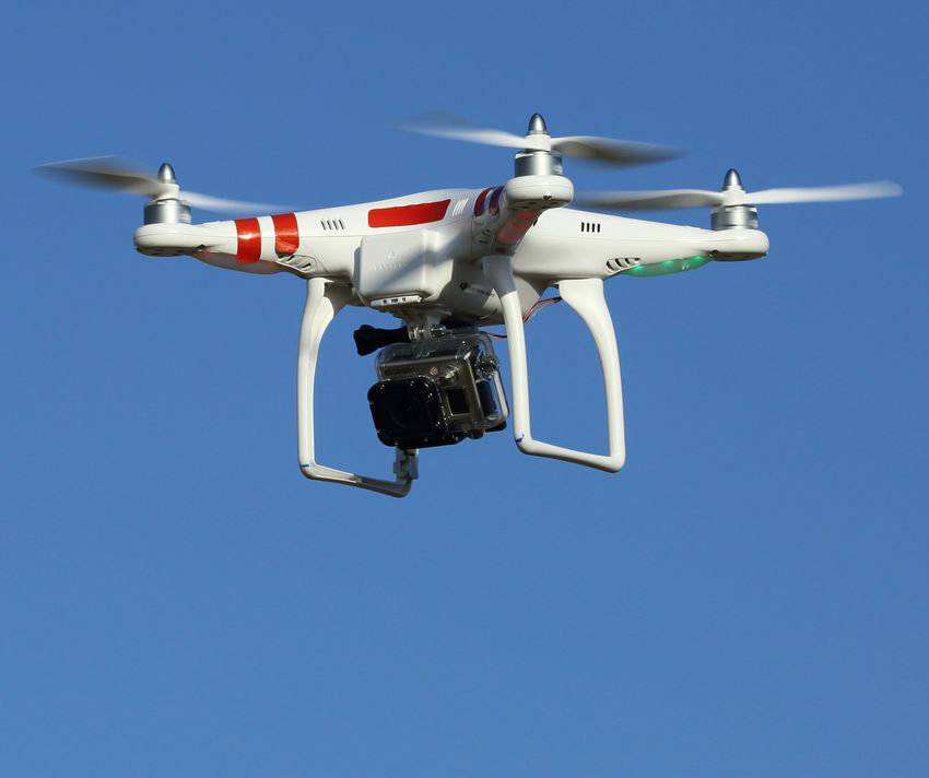
Cover photo: Quad copter in flight. (Credit: Don Mccullough / Flickr Creative Commons)
DISCLAIMER: The authors’ views expressed in this publication do not necessarily reflect the views of the U.S. Agency for International
Development or the U.S. government.
UNMANNED AERIAL VEHICLES LANDSC APE ANALYSIS 2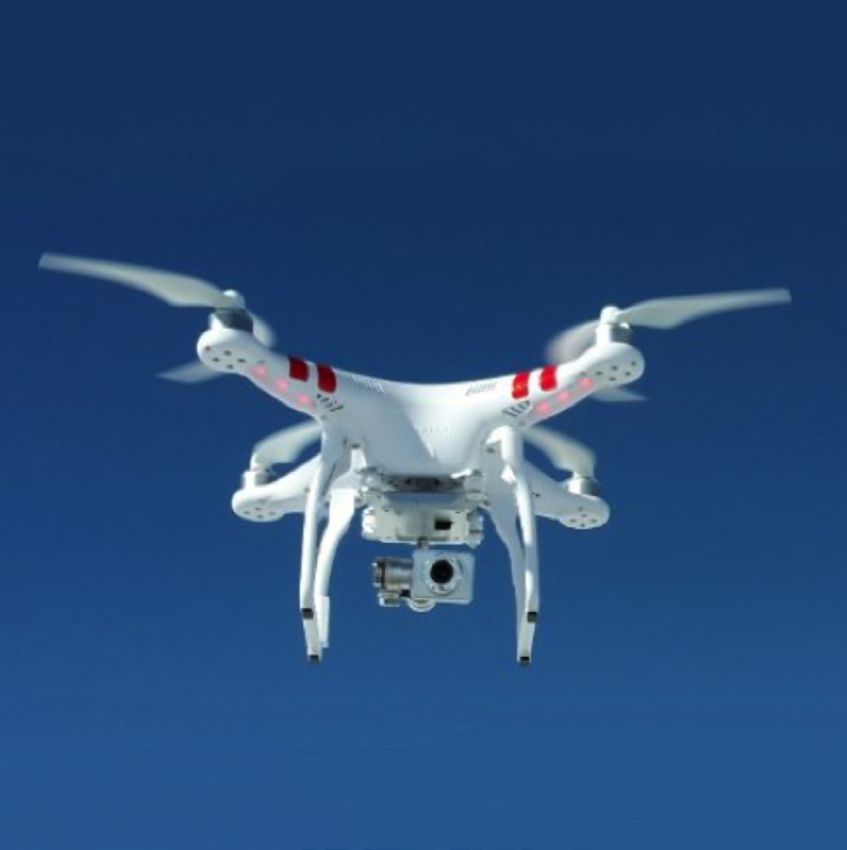
INTRODUCTION

The USAID Global Health Supply Chain Program – Procurement and Supply
Management (GHSC-PSM) project functions to ensure uninterrupted supplies
of health commodities in support of U.S. government (USG)-funded public
health initiatives around the world. It is a USAID program implemented by
Chemonics International.
GHSC-PSM is working with USAID to explore the potential of incorporating unmanned aerial vehicles (UAVs)
for moving health commodities through public health supply chains, with a goal of undertaking a pilot by the end
of 2017. There are few practitioners using UAVs for cargo delivery in the development context. With the size of
the project and its focus, GHSC-PSM is in a unique position to begin incorporating UAV technology.

As a first step, GHSC-PSM completed the UAV Landscape Analysis to assess the various technologies, UAV actors,
regulations, pilots undertaken, and lessons learned from existing use of UAVs in the development context. This
analysis is being used to inform the project’s work toward a pilot project.

GHSC-PSM anticipates that incorporating UAVs into its supply chains could have significant beneficial impact on
how commodities, emergency cargo and lab tests are moved around countries in the future.

The project also anticipates that the analysis will be a resource for others interested in this sector.

The contact for GHSC-PSM on UAV activities is Scott Dubin – Sr. Distribution & Transportation
Specialist, sdubin@ghsc-psm.org.

                         UNMANNED AERIAL VEHICLES LANDSC APE ANALYSIS 3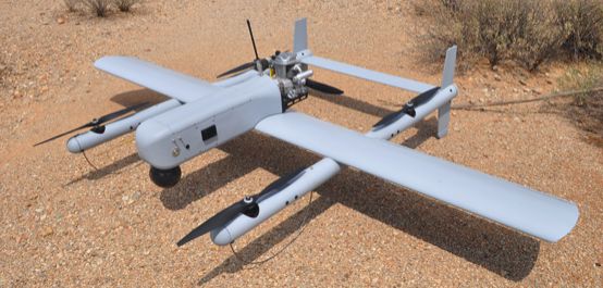
TABLE OF CONTENTS
1. INTRODUCTION....................................................................................................................................................................................... 6
       A.    Background: The Growing Use of UAVs in the Development Context..................................................................................6
       B.    Applications in the Humanitarian Sector...................................................................................................................................................6
       C.    The UAV Landscape Analysis............................................................................................................................................................................8
       D.    Scope of Work and Methodology..................................................................................................................................................................8
       E.    Workflow and Expected Results....................................................................................................................................................................9

II. TECHNOLOGY, ACTORS, AND REGULATIONS..................................................................................................11
       A.    UAV Types and Technology..............................................................................................................................................................................11
       B.    UAV Types: Fixed-Wing, Multi-Rotor and Hybrid...............................................................................................................................11
       C.    Commercial Drone Projects..........................................................................................................................................................................14
       D.    UAV Actors and Partnerships in the Humanitarian Sector..........................................................................................................15
       E.    UAV Regulations....................................................................................................................................................................................................16
       F.    Perception of UAVs.............................................................................................................................................................................................16

III. KEY CASE STUDIES...........................................................................................................................................................................26
       A.	Case Study 1: MSF Using Multi-Copter Drone to Transport Tuberculosis Sputum Samples in Papua New
           Guinea..........................................................................................................................................................................................................................26
       B. Case Study 2: UAV Transportation of Blood and Stool Samples in Madagascar..........................................................27
       C. 	Case Study 3: Using Drones to Transport Dried Blood Spot Samples with Comparative Cost Analysis in
           Malawi...........................................................................................................................................................................................................................28
       D. Case Study 4: Delivering Transfusion Blood and Other Medical Items Across Rwanda...........................................29
       E. Case Study 5: UAVs in Out-of-Hospital Cardiac Arrest in Stockholm County, Sweden.........................................31
       F. Case Study 6: UAVs in Community Emergency Response Teams in the Maldives......................................................32

IV. CONCLUSION............................................................................................................................................................................................33
       A. SWOT Analysis of UAVs in the Humanitarian Supply Chain........................................................................................................33
       B. Health Economic Analysis..................................................................................................................................................................................33
       C. The Way Forward: Final Evaluation and Recommendations..........................................................................................................35

REFERENCES.......................................................................................................................................................................................................37
ANNEX 1: LIST OF HUMANITARIAN UAV PROJECTS TO DATE..........................................................43
ANNEX 2: HUMANITARIAN UAV CODE OF CONDUCT AND GUIDELINES............................49
ANNEX 3: LIST OF CURRENTLY AVAILABLE UAVS.............................................................................................56

                                                   UNMANNED AERIAL VEHICLES LANDSC APE ANALYSIS 4
LIST OF PICTURES, TABLES AND FIGURES
FIGURE 1: Map Showing the Locations of Some Known Humanitarian UAV Projects....................................... 8
FIGURE 2: Methodology, Workflow, and Expected Results.....................................................................................10
PICTURE 1: Fixed-Wing UAV...................................................................................................................................... 12
PICTURE 2: Multi-Rotor UAV..................................................................................................................................... 12
PICTURE 3: Hybrid UAV.............................................................................................................................................. 13
TABLE 1: Comparative Merits of Different UAV Technologies..............................................................................13
TABLE 2: C
urrent Laws and Regulations in Relation to the Use of UAVs
in PEPFAR Countries.................................................................................................................................... 18
FIGURE 3: SWOT Analysis............................................................................................................................................ 33
LIST OF ABBREVIATIONS
AED................................................................................................................................ Automated external defibrillator
ART.................................................................................................................................................... Antiretroviral therapy
BVLOS........................................................................................................................................ Beyond visual line of sight
DBS............................................................................................................................................................. Dried blood spot
DVLOS..........................................................................................................................................Digital visual line of sight
EMR....................................................................................................................................... Emergency medical response
FSD................................................................................................................................Swiss Foundation for Mine Action
GIS......................................................................................................................................Geographic information system
IOM.................................................................................................................... International Organization for Migration
LMICs........................................................................................................................ Low- and middle-income countries
MSF...............................................................................................................................................Médecins Sans Frontières
NITAGs...........................................................................................National Immunization Technical Advisory Groups
OCHA............................................................. United Nations Office for the Coordination of Humanitarian Affairs
OHCA..................................................................................................................................Out-of-hospital cardiac arrest
PEPFAR...................................................................................................... President’s Emergency Plan for AIDS Relief
PNG......................................................................................................................................................... Papua New Guinea
RTF....................................................................................................................................................................... Ready to fly
SAR............................................................................................................................................................ Search and rescue
UAS............................................................................................................................................ Unmanned aircraft system
UAV............................................................................................................................................... Unmanned aerial vehicle
UNDP..................................................................................................................United Nations Development Program
UNFPA........................................................................................................................... United Nations Population Fund
UNICEF.......................................................................................................................... United Nations Children’s Fund
VLOS......................................................................................................................................................... Visual line of sight
VTOL........................................................................................................................................ Vertical takeoff and landing
WHO........................................................................................................................................ World Health Organization
UNMANNED AERIAL VEHICLES LANDSC APE ANALYSIS 51. INTRODUCTION Important lessons from these early-stage projects —
covering acceptability, proof of concept and rigorous
A. BACKGROUND: THE GROWING USE OF testing of the technology — are currently setting the
UAVS IN THE DEVELOPMENT CONTEXT stage for improvements and the potential future
The use of unmanned aerial vehicles (UAVs) in the expansions of UAVs in health supply chains in the
development context is relatively new but has been development context and beyond.
growing significantly over the last three years (see Figure
B. APPLICATIONS IN THE HUMANITARIAN
1). The collection of information, such as aerial videos
SECTOR
and photographs, is common since the simple function
of carrying a sensor and remotely triggering a camera UAVs have numerous applications in the humanitarian
has matured sufficiently for the consumer market. Now context and direct applications and indirect applications
attention has turned toward a new type of application: for the public health sector more broadly.
using UAVs to deliver items. The hopes are high that
UAVs can address some of the most common health UAVS AND THE HEALTH SUPPLY CHAIN
logistics challenges by circumventing problematic UAVs are evidently well equipped to access difficult
infrastructure on the ground, speeding up delivery terrain, which has led NGOs to consider them as a
processes, and making supply chains more responsive. tool in the humanitarian supply chain — particularly in
Much media attention has been directed toward this situations where time is critical in delivery. 1 TB testing
issue, as technology companies are preparing regulators (seen in the MSF case study below) is one example that
and policymakers for a future where UAVs will make has shown the possible time that can be saved with
deliveries of consumer goods and postal shipments. UAVs, but such systems could also improve the
However, the most UAVs that can carry and deliver emergency response to viruses such as Lassa or Ebola,
things are merely prototypes and are not yet ready for where quarantine is necessary. Cases could be
the consumer market. quarantined in their homes while UAVs carrying samples
A few limited tests of UAVs have taken place in the are dispatched for testing.
health supply chain field. Médecins Sans Frontières UAVs also may offer a cheaper alternative to conventional
(MSF) paved the way in 2014 as the first humanitarian aircraft where shipments of high-frequency, low-weight
organization to test the use of UAVs to deliver sputum items are concerned. Capitalizing on this for cold chain
samples for tuberculosis testing in Papua New Guinea. products seems like an obvious move. Of course, the
The innovative trial indicated that while the UAV system technology is the limiting factor: battery life and low
needs significant improvement, it might be a useful payload prevent goods of reasonable size being delivered
method of connecting remote health centers to central any meaningful distance. However, future developments
hospitals, labs, and distribution centers in the future. could change this: solar-powered drones are one option,
Two years later, the “future” has arrived with several as are drones with combustion engines. There is also
ongoing UAV trial programs and updated UAV the possibility of UAVs that can automatically dock with
technology to tackle the challenges of health supply charging stations (possibly solar powered) along a set
chain delivery in hard-to-reach areas. Even though route, effectively hopping from one station to the next
technological challenges remain — as well as restrictive as far as required. 2
regulatory issues — international organizations such
as WHO, UNICEF, UNFPA, and UNDP have followed 1
Robohub. How can we use drones in the humanitarian and health sector.
in the footsteps of MSF. On the national side, the http://robohub.org/how-can-we-use-drones-in-the-humanitarian-and-
health-sector/ (accessed November 7, 2016).
government of Rwanda is currently in the early stages
2
obohub. How can we use drones in the humanitarian and health sector.
R
of piloting a national UAV cargo delivery system, where http://robohub.org/how-can-we-use-drones-in-the-humanitarian-and-
the delivery of emergency medical supplies is essential. health-sector/ (accessed November 7, 2016).
UNMANNED AERIAL VEHICLES LANDSC APE ANALYSIS 6UAVS IN SURVEYING UAVS IN SEARCH AND RESCUE
Using geo-referenced photography (or photogrammetry), In emergency response operations, UAVs can be helpful
UAVs are already being used to quickly survey and to emergency medical response (EMR) personnel
produce large 2D and 3D maps of astounding accuracy. because they quickly and easily provide real-time
The use of UAVs is becoming more common, particularly surveillance over a natural disaster area or accident
within the agriculture and construction industries. scene. UAVs provide a faster and cheaper option than
Humanitarian actors are also exploring their use in satellites to scan the scene from above. They can also
various emergency and recovery situations. The fly under the clouds and closer to the scene, providing
International Organization for Migration (IOM) has higher quality images. In search and rescue operations,
been using UAVs in Haiti for several years for flood UAVs can be equipped with heat cameras, making it
mitigation and camp management; in the Philippines, possible for them to more easily track missing and
MEDAIR mapped areas affected by Typhoon Haiyan; injured people after a landslide, tsunami, or earthquake.
and the World Bank has funded a large-scale mapping
effort of informal settlements in Tanzania.The availability UAVS IN EMERGENCY RESPONSE
of UAV-generated maps has already led to faster
response during cholera outbreaks in Tanzania. 3 There are few medical situations where time is more
valuable than during organ transplants. A heart can only
As with all innovation, technology is the deciding factor survive for four to six hours outside the body, so the
on feasibility. The Swiss Foundation for Mine Action process of matching a recipient with the same blood
(FSD) has been exploring the use of drones in type, body size, and geographic location must occur
humanitarian demining contexts and for broader quickly. Research has shown that while there is no clear
humanitarian applications for many years. There are medical advantage for the victim to be transported by
many projects to mount instruments such as thermal air ambulance versus ground ambulance, air evacuation
sensors on UAVs to detect potential minefields. This does provide more viable organs than traditional ground
seems like a reasonable goal; drones that can map units. Could drones offer paramedics on the scene a
radiation already exist. tool to harvest and send organs on par with the system
of getting the organs to the hospital by air?
UAVS IN PUBLIC HEALTH PREVENTION Cardiac arrest is another situation where time is of
Besides transportation and mapping, UAVs can be used the essence. In cases where defibrillation is the only
from a public health prevention perspective, particularly option for revival, drones might again provide a swift
in vector control. Projects in Brazil tackling Zika- transportation option. As explored in one of the
carrying mosquitoes and in Ethiopia to combat the case studies below, the possibility of UAVs arriving
Tsetse fly are using increased maneuverability to on the scene with a defibrillator attached is already
improve the targeted use of sterile vectors to stem under consideration.
the spread of disease.4 5
3
F SD. UAV case studies. http://drones.fsd.ch/en/tag/case-study/ (accessed on
November 30, 2016).
4
refeitura de Vitoria. Zika: Prefeitura usa drones no combate aos focos do
P
mosquito. http://www.vitoria.es.gov.br/noticia/zika-prefeitura-usa-drones-
no-combate-aos-focos-do-mosquito-19703 (accessed November 7, 2016).
5
he UAE Drones for Good Awards. Drones in support of sustainable rural
T
development in Ethiopia. https://dronesforgood.ae/finals/drones-support-
sustainable-rural-development-ethiopia (accessed November 6, 2016).
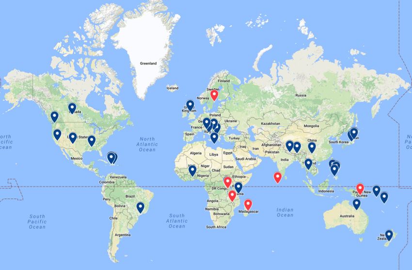
UNMANNED AERIAL VEHICLES LANDSC APE ANALYSIS 7Figure 1: Map showing the locations of known humanitarian UAV projects. The data come from UAViators and can be viewed in
detail in Annex 1, or as an interactive map at: https://www.google.com/maps/d/viewer?mid=1wdIigD6V9KZFd_vaCOVGA_Rn-
lI&ll=5.140328190247929%2C-16.071904899999907&z=3
C. THE UAV LANDSCAPE ANALYSIS D. SCOPE OF WORK AND METHODOLOGY
Unmanned Aerial Vehicles Landscape Analysis: Applications GLOBHE carried out a UAV situation analysis and
in the Development Context is a comprehensive, in-depth UAV mapping analysis, involving a critical review of
investigation of the potential and limitations of using UAVs in a development and health supply chain context.
drones for development with an emphasis on health This included:
supply chains. It summarizes the findings of UAV and
health supply chain researchers, stakeholder • A n assessment of the sector over the last three
consultations, and case study analysis of field deployments. years;
The analysis includes an assessment of the sector over • Identification of factors that contributed to the
the last three years, successful cases, and key challenges achievement of the positive results recorded;
and gaps. The aim of the investigation is to provide a • Analysis of the strengths, weaknesses, opportunities,
foundation of background knowledge for actors and challenges of UAVs in a development and health
interested in exploring the use of UAVs in health supply supply chain context; and
chains in a development context and beyond. • Identification of the key gaps that require exploration
in the future.
UNMANNED AERIAL VEHICLES LANDSC APE ANALYSIS 8The mapping analysis employed both a literature review -- Conditions (e.g., electricity, Internet connectivity,
and a collection of previous experiences from those staff on site, cellular connectivity, etc.)
involved in writing the report, as well as consultations -- Days and hours of operation
with cargo UAV providers such as Matternet and -- Staffing at sites
Zipline and international organizations currently using -- Proposed takeoff and landing locations
cargo UAVs such as UNICEF and MSF. In most sectors, -- Restrictions
it was possible to refer to these actors as “market
• Distances:
leaders”; however we feel it is important to highlight
-- Road distance between sites vs. direct distance
that, in the current discourse, it is too early to identify
between sites
any of these companies as such. To do so risks
marginalizing many qualified companies that have not • Frequency:
yet engaged with the market. -- Number of shipments per hour
-- Number of shipments per day
A detailed analysis of existing cases and literature -- Number of shipments per week
identified the successes and challenges for a list of key -- Urgency
case studies. These were then collated to highlight
recurring themes across this fast-moving sector. Strategic • Current Solution:
focus and programs are proposed based on the -- How is the item currently transported?
synthesized successes, gaps, challenges and issues. -- What are the costs (direct and indirect)?
-- How much time does current transportation
GLOBHE identified opportunities for UAVs in the health take?
supply chain by looking at key elements including, but -- What is the reliability?
not limited to: -- What are the pain points?
• UAV Technology: • Budget:
-- Types, capabilities, and past and ongoing field tests -- Budget and duration
-- Timeline
• Application:
-- Interest (Why is drone delivery being considered?) -- Decision-makers
-- Problems -- Opportunities for expanded work
-- Project goals and objectives E. WORKFLOW AND EXPECTED RESULTS
• Payload: GLOBHE conducted the UAV Landscape Analysis by
-- Description and type (especially high-impact, analyzing a number of key case using a desk study
low-weight, cold chain goods, e.g., medicine, approach of relevant UAV research reports and articles,
diagnostics, stat specimens, spare parts, transfusion
conducting stakeholder consultations, and obtaining
blood, anti-venom, etc.)
feedback from field deployments.
-- Weight
-- Volume The selection and demarcation of relevant key case
-- Dimensions of shipment studies was done primarily based on theme (UAV case
-- Value studies relevant to health supply chains and, preferably,
-- Special handling requirements (e.g., temperature, diagnostic services) and secondarily based on geography
vibration tolerance, etc.) (UAV case studies relevant to a development context
-- Other special characteristics and, if possible, in a President’s Emergency Plan for
• Location: AIDS Relief [PEPFAR] focus country or region). In
-- General area/location addition, projects considered too basic (i.e., prototype
-- Ground experience, knowledge, and presence at testing in test environments) were not selected as key
project locations case studies.
UNMANNED AERIAL VEHICLES LANDSC APE ANALYSIS 9Six case studies passed the selection criteria and To successfully analyze the degree of success specifically
underwent further analysis. Four of the selected studies within health supply chains, a broader knowledge
(Madagascar, Malawi, Papua New Guinea, and Rwanda) foundation needs to be adopted, including a change
fulfill both the thematic and geographical criteria and management perspective to analyze what is required
have been determined to be the only “substantial” cases from surrounding elements and factors affecting the
existing at the time of writing (November 2016). The supply chain. The work will result in a UAV Landscape
other two key case studies (Sweden and Maldives) were Analysis report describing the potential and limitations
selected for thematic relevance (Sweden) and potentially of UAVs in health supply chains in a development context.
thematic relevance (Maldives).
The methodology, workflow, and expected results are
Based on the findings of the case studies, a problem presented in Figure 2.
analysis was carried out, and for selected key case studies,
relevant data for landscape analysis were gathered and
reviewed for a structured explanation of the key lessons.
GLOBHE applied helpful tools such as the SWOT model
and cost-benefit models when applicable.
Methods:
-- Literature studies
-- Interviews
-- General problem
analysis Expected Results:
-- Cost benefit UAV Landscape Analysis
analysis report describing the use
-- SWOT of UAVsin:
• health logistics
Input: • diagnostic services
Case studies Analysing if UAVs can:
Mapping of UAVs in • improve access to care
Literature: health supply chains
-- Scientific papers • improve quality of care
(development context)
-- Relevant Reports Knowledge about:
Regulations • technical constraints
• risk and opportunities
• rules and regulations
Knowledge Foundation: • UAVs in a health
economic perspective
-- Supply chain management
(limited)
-- Change management
• innovations/application
-- Process engineering knowledge
-- Case study approach
Figure 2: Methodology, Workflow, and Expected Results
UNMANNED AERIAL VEHICLES LANDSC APE ANALYSIS 10The expected results include the idea that UAVs have companies known today, but they have not yet entered
the potential to improve access to essential medicine the civilian market. The association with military
in hard-to-reach areas, speed up transportation of interventions has also been a deterrent for organizations
medicine and medical supplies, provide access to faster such as MSF, which fiercely guards its neutrality among
diagnostic services, and complement existing health actors in combat zones, choosing to limit UAV use to
supply chains. As to where this will lie on the cost- projects in stable contexts.6
analysis scale, it is difficult to quantify with the limited
data available, but it is expected that programs that The technology and operationalization of UAVs for
have now started will be able to provide a comparable, cargo delivery is still in the development phase and
or cheaper, option than traditional deliveries. In addition, much is likely to happen over the next five years. Many
UAV technology potentially reduces the need for endless of the companies that are based in Europe or the United
training on forecasting. If the delivery system is a text States that are developing cargo UAVs have already
message away via a drone delivery, no one needs to sought or are seeking to first operationalize their
forecast; they request amounts/deliveries daily. However, technology in development contexts, possibly due to
regulatory limitations and technical constraints currently less stringent regulations. There is a fair degree of
limit the full potential from a health supply chain criticism of that approach, as it is understood that many
perspective. Further cost analysis of health economics companies are starting to operationalize in a
will likely be needed, as well as analysis of risk and development context to provide a proof of concept
opportunities and of innovations and applications. or gain a competitive advantage by gaining experience
with prototypes before entering more regulated
II. TECHNOLOGY, ACTORS, AND European and United States airspace. Some of the
REGULATIONS known actors that have tested cargo UAVs in Europe
or the United States without forming development
A. UAV TYPES AND TECHNOLOGY partnerships are Amazon, Google, DHL and Microdrones,
To date, the majority of UAVs used in health supply chain as of November 2016. At the same time, some start-ups
delivery have been small or mini-sized devices weighing are building models specifically to address the unique
approximately 5-15 kg. These models are prototypes, challenges (e.g., limited infrastructure, limited
not yet available on the market and limited in flight range possibilities for storing of medicine, limited investment
and time by power capacity and battery size. Models are capacities) that are encountered in the developing
developed with ease of use and safety in mind, but field world. Examples include Dr. One, UAVaid, Wings for
experience has shown that the existing technology Aid and Drones for Development.
usually requires several staff from the developing company
to be on site for set up, piloting, and trouble-shooting. B. UAV TYPES: FIXED-WING,
It should be assumed that to ensure local capacity, MULTI-ROTOR AND HYBRID
extensive training would be necessary, as UAVs need to There are primarily three types of UAVs used in health
be both operated safely and maintained. Many of the supply chain delivery: fixed-wing drones, multi-rotor
companies that are currently developing UAVs with drones, and hybrid drones. The most suitable drone
cargo capacity are start-ups or businesses that specialize type depends on the application, environmental
in manufacturing consumer UAVs. conditions, regulatory framework, organizational needs,
associated cost, and supporting infrastructure, among
Long-range aircraft-sized UAVs have not been used for
other considerations. In this section, we will explore
humanitarian and health supply chain purposes, possibly
the suitability of each drone type in different contexts.
because this technology remains in the military domain.
It is believed that companies such as Boeing, Lockheed 6
MSF. Drone aid: a useful tool with a toxic image. http://msf-analysis.
Martin, Northrup Grumman and others would have org/drone-aid-a-useful-tool-with-a-toxic-image/ (Accessed
technology that is far more advanced than many of the November 3, 2016).
UNMANNED AERIAL VEHICLES LANDSC APE ANALYSIS 11Regardless of their type, the majority of UAVs fly by
autopilot, following predetermined flight paths and using
GPS for orientation. A pilot monitors the flight progress
and makes suitable adjustments when necessary. The
UAVs may have built-in sensors for avoiding obstacles
and built-in safety measures such as parachutes in case
of a fault. Safety measures and systems are of utmost
importance in the cargo UAV fields, as craft usually
need to operate beyond the visual line of sight, often
fly over inhabited areas, and may carry dangerous goods.
FIXED-WING UAVS
Fixed-wing drones, with two wings and the design of a
small airplane, are typically used to cover longer
distances and carry heavier payload.Typically, the fixed-
wing drone can fly at speeds around 100 km/hour and
cover a round trip of 150 km, operating in up to 50
km/hour winds. Normally the payload ability varies from Picture 1: Fixed-wing UAV | JoeB52 | Creative Commons
1.5-4.5 kg. Fixed-wing drones (see Picture 1) are suitable
for transportation of cargo over longer distances,
making them suitable for health supply chain delivery.
A major drawback of fixed-wing drones is that they are
not designed for vertical takeoff and landing (VTOL)
and often require a landing strip of open space
approximately equivalent to a soccer field/two parking
lots.This means they are less suitable to pick up samples
for diagnostic services and are instead better for air-
drop/parachute delivery of emergency medical supplies
to health centers in hard-to-reach areas.
MULTI-ROTOR UAVS
Multi-rotor drones are mostly used for shorter flight
times and shorter distances, for instance to record films/
pictures for stakeholders such as search and rescue
(SAR) teams or to transport lighter cargo. The most
common design is the multi-rotor drone with four
propellers, the quad-copter drone. Models with one
rotor (helicopter) and up to eight rotors (octo-copters) Picture 2: Multi-rotor UAV | Capricorn4049 | Creative Commons
also exist.The main advantage of the multi-rotor drone
is its ability to take off and land vertically, making it
suitable not only for delivering but also for picking up a payload of 2 kg. The UAVs can operate in a network
samples to improve diagnostic services. The main structure with a replacement of battery at designated
drawback is that flight time and therefore distance is posts or health clinics to cover greater distance. Multi-
severely shortened. However, recent technology updates rotor drones can be operated using smart phones, tablets,
now enable distances of up to 20 km (round trip) with or regular PCs and follow pre-determined GPS routes.
UNMANNED AERIAL VEHICLES LANDSC APE ANALYSIS 12HYBRID UAVS
Hybrid drones are a new but promising concept, as
they are equipped with both wings and rotors which
allow for vertical takeoff and landing (like the multi-
rotor drone) as well horizontal flight like fixed-wing
drones.This makes it possible to cover longer distances
and carry heavier cargo than multi-rotor drones. Similar
software applications are available for hybrid drones as
for fixed-wing and multi-rotor drones.
Picture 3: Hybrid UAV | Taken from: https://latitudeengineering.com/
Table 1: comparative merits of different uav technology used for the delivery of cargo
Fixed wing Multi-rotor Hybrid
Range Up to160 km About 20 km About 80 km
Payload Up to 5 kg Up to 2 kg Up to 5 kg
Launch Catapult Vertical Vertical
Variations Gas or electric Gas or electric Gas or electric
• Long range • M aneuverability in small • Vertical take-off and landing but
• More efficient spaces with comparable range to fixed
• Heavier payloads than • Vertical takeoff and landing wing
multi-rotor • Generally cheaper • More options for landing and take-
Advantages • More stable flying • Can fly with a minimum of off sites
• Well established two rotors • Heavier payloads than multi-rotor
concept with the • Easier for “safe” emergency landings
weight of aerospace
engineering behind it
• Large space required • Low payload limit • Generally more expensive
for take-off and landing • Generally more complex • Neither as long range as fixed wing
(no VTOL) designs (high software nor as maneuverable as multi-rotor
• Limited maneuverability requirements to keep in
Disadvantages in small spaces the air) requiring expert
• Emergency landings are maintenance and trained
generally less easy to staff at health centers
control • Limited range
• Inefficient in some settings
• Zipline • Matternet • Amazon
• Wings for Aid • Flirtey • Google
• UAVaid • Microdrones • DHL
Manufacturers
• Drones for Development - Dr. One.
• Quantum Systems
• Vayu
• G
overnment of • MSF • MSF (planned)
Rwanda • World Bank • We Robotics (planned)
Example of Users
• MOAS • UNICEF
• Swiss Post
UNMANNED AERIAL VEHICLES LANDSC APE ANALYSIS 13C. COMMERCIAL DRONE PROJECTS first time worldwide that a parcel service provider has
directly integrated a parcelcopter logistically into its
AMAZON delivery chain. Private customers in Reit im Winkl and
on the Winklmoosalm Plateau were invited to test out
Country US, UK, Austria, and Israel
the specially developed Packstations, dubbed
Actors Amazon Prime Air
Parcelcopter Skyports. During the three-month trial
UAV technology Hybrid and multi-rotor period, they could simply insert their shipments into
Payload Unknown the Skyport to initiate automated shipment and delivery
Date of operation Ongoing (prototype stage) via Parcelcopter. A total of 130 autonomous loading
Distances 10 miles+ and offloading cycles were ultimately performed.8
Frequency Unknown
Goal of project Commercial drone deliveries GOOGLE
Country United States
Amazon Prime Air is a future service that will deliver
packages up to five pounds in 30 minutes or less using Actors Google X
small drones. Flying under 400 feet elevation and UAV technology Hybrid
weighing less than 55 pounds, Prime Air vehicles will Payload Unknown
take advantage of sophisticated “sense and avoid” Date of operation August 2016
technology, as well as a high degree of automation, to Distances Unknown
safely operate beyond the line of sight to distances of
Frequency Unknown
10 miles or more (when and where Amazon has the
Goal of project Commercial drone deliveries
regulatory support needed). Amazon has Prime Air
development centers in the United States, the United
Kingdom, Austria, and Israel.The company is testing the Google’s parent company, Alphabet, plans to make
vehicles in multiple international locations.7 commercial drone deliveries by 2017 as part of Project
Wing. Google X, the division of Alphabet responsible
for Project Wing, received approval from the White
DHL House in August 2016 to test Project Wing at a U.S.
Country Germany site. The drones will be tested at one of the six sites
Actors DHL Parcel approved by the Federal Aviation Administration (FAA).9
UAV technology Tiltwing aircraft and quadrocopter
Payload Unknown
Date of operation January-March 2016
Distances Unknown
Frequency 130 deliveries
Goal of project Commercial drone deliveries
DHL Parcel has successfully concluded a three-month
test of its third Parcelcopter generation. The trial run,
part of a larger research and innovation project, was
conducted between January and March 2016 in the
8
DHL. Successful Trial Integration of DHL Parcelcopter into Logistics
Chain. http://www.dhl.com/en/press/releases/releases_2016/all/parcel_
Bavarian community of Reit im Winkl. It represents the ecommerce/successful_trial_integration_dhl_parcelcopter_logistics_chain.
html (accessed November 6, 2016).
9
usiness Insider. Google’s secretive drone delivery project gets go ahead.
B
7
mazon. Amazon Prime Air. https://www.amazon.com/
A http://www.businessinsider.com/google-project-wing-drone-service-2016-
b?node=8037720011 (accessed November 4, 2016). 8?r=US&IR=T&IR=T (accessed November 6, 2016).
UNMANNED AERIAL VEHICLES LANDSC APE ANALYSIS 14FLIRTEY drones is not expected within the next five years. The
focus is primarily on their use in exceptional cases or
Country United States
the transport of special items.11
Actors NASA, Virginia Tech University, Flirtey
UAV technology Multi-rotor D. UAV ACTORS AND PARTNERSHIPS IN
THE HUMANITARIAN SECTOR
Payload 4.5 kg
Date of operation July 2015 To date, few organizations that have used UAVs in
humanitarian programs have developed their own
Distances Up to 16 km
internal capacity. 12 Instead, most humanitarian
Frequency Unknown
organizations have been working with UAV companies
Goal of project Transportation of medical supplies to (Matternet, Zipline, and DJI, to name but a few) or in
rural health clinic
partnership with other actors capable of UAV
deployments. Complementing this, UAViators works to
The first federally approved drone delivery in the United
promote safe, coordinated, and effective use of UAVs
States took place in July 2015 and was conducted by
and has developed a comprehensive code of conduct
an Australian startup, Flirtey, delivering medical supplies
(see Annex 2) that can be used as a guide to organizations
to a rural health clinic in Virginia. The Federal Aviation
interested in exploring the use of UAVs.The Humanitarian
Administration approved Flirtey to make the delivery
UAV Network and WeRobotics seek to develop local
as part of a joint venture between NASA,Virginia Tech
flying labs for personnel training purposes.
University, and several health care organizations in
Virginia called “Let’s Fly Wisely.”10 During the development phase of UAVs in humanitarian
projects, it has been quite common for UAV companies
SWISS POST, SWISS WORLDCARGO, AND to provide their technology free of charge to humanitarian
MATTERNET organizations and/or local ministries/governments for
them to test their solutions and perfect their technology
Country Switzerland in field conditions and in countries where regulations
Actors Swiss Post, Swiss Airlines, and are more favorable compared to the “home market.”
Matternet Some partnerships that have been established in regards
UAV technology Multi-rotor to health supply chains in a development context are:
Payload Unknown
• Matternet and MSF in Papua New Guinea
Date of operation July 2015-present
• Matternet and WHO in Bhutan
Distances Unknown • Matternet, UNICEF, and the Malawi Ministry of
Frequency Unknown Health
Goal of project Commercial delivery • Matternet and the Inter-American Development
Bank (to be implemented in Dominican Republic)
Swiss Post, Swiss WorldCargo and Matternet are jointly • Zipline, government of Rwanda, GAVI, and UPS
testing the commercial use of logistics drones.The three • Vayu, Stony Brook University, the government of
companies are investigating specific uses of drone Madagascar, and USAID
technology and examining the cost-effectiveness of
these business ideas. The first tests were carried out 11
Swiss Post. Swiss Post, Swiss WorldCargo and Matternet start drone tests.
in July 2015 for this purpose. The widespread use of https://www.post.ch/en/about-us/company/media/press-releases/2015/
swiss-post-swiss-worldcargo-and-matternet-start-drone-tests (accessed
November 7, 2016).
12
FSD. Drones in Humanitarian Action: A Guide to the Use of Airborne Systems
10
Fortune. Drone makes first legal doorstep delivery in milestone flight. in Humanitarian Crises. (Unpublished version. Published version available
http://fortune.com/2015/07/17/faa-drone-delivery-amazon (accessed December 2, 2016). http://drones.fsd.ch/wp-content/uploads/2016/11/
November 7, 2016). Drones-in-Humanitarian-Action.pdf
UNMANNED AERIAL VEHICLES LANDSC APE ANALYSIS 15• DJI, UNDP, and government of Maldives Humanitarian and development actors may be able to
• WeRobotics, Humanitarian UAV Network, and Vayu obtain special permits by engaging directly with
(to be implemented in Nepal) government actors. Overall, many of the countries
• Stork and Ifakara Health Institute, with funding from where humanitarians are working still lack legal UAV
Human Development Innovation Fund and Saving frameworks, meaning that the use of UAVs will probably
Lives at Birth Grand Challenge need to be cleared on an ad hoc basis with local and
national authorities.13 This can create opportunities but
E. UAV REGULATIONS also problems if not carefully coordinated.
UAV regulations differ from country to country, and
even within countries. Currently, regulatory frameworks In general, a local partner entity that is familiar with
present a big challenge for the UAV sector for both national procedures should handle the processes of
commercial and humanitarian purposes. Regulations obtaining permits. Even where regulations do not exist,
stating that UAVs have to fly within visual line of sight governments and national authorities should be fully
(VLOS) of the operator limit the distance and potential informed about projects that use UAVs.The amount of
of using UAVs in health supply chain delivery. Countries time that is required from first engagement varies
that do allow UAVs to fly autonomously from point A greatly, and usually several actors are involved. If there
to point B — outside VLOS — allow the opening up of is a precedent of use of similar UAV technology without
further uses and applications of UAVs, not least from a incident in the country, the process to obtain permits
health supply chain perspective. Some regulations permit tends to be smoother. If, on the other hand, the
cargo delivery, but not dropped or parachuted items. technology is unknown or without precedence, obtaining
Regulators might provide special permits for humanitarian permits may take months to a year, flight paths may
purposes, and permissions for beyond visual line of sight need to be adjusted, or, in some cases, permission to
(BVLOS) can be applied for (depending on the country), fly may not be granted at all.
but this tends to be a long and complicated process. The International Civil Aviation Organization (ICAO),
There are some ongoing developments in digital vision the regulating body responsible for international aviation,
line of sight (DVLOS), where digital cameras are being does not yet stipulate regulations for autonomous or
used to keep the UAVs in line of sight, which potentially low-level operations but only for cross-border
can serve as an alternative. operations.14 This has resulted in member states
If no regulatory changes are made, the application of formulating their own regulations, creating a situation
cargo drones will be limited on a global scale. Currently, that leads to a lack of standardization across countries.15
regulations in Europe and the United States greatly A repository of information on country regulations is
limit the use of cargo drones based on security and available at www.uavregulations.info.
aviation fears, while some countries in sub-Saharan F. PERCEPTION OF UAVS
Africa have opened themselves up for such applications.
Rwanda has put itself at the forefront and aims to be One of the main concerns regarding the use of UAVs
the first country in the world with a nationwide UAV in the development context is perception of their use
delivery network, with health supply chain delivery at among local populations. In a recent study, 57 percent
its core.
In the spring of 2016, Rwanda launched a national UAV
13
OCHA. Unmanned Aerial Vehicles in Humanitarian Response. OCHA
Political Studies Series 10. June 2014. https://docs.unocha.org/sites/
regulation framework, making it possible to coordinate dms/Documents/Unmanned%20Aerial%20Vehicles%20in%20
the safe use of UAVs in the country. Other countries Humanitarian%20Response%20OCHA%20July%202014.pdf
have started to follow but seem to be more restrictive, 14
FSD. Drones in Humanitarian Action: A Guide to the Use of Airborne Systems
in Humanitarian Crises. (Unpublished version. Published version available
such as Uganda, where the UAV regulatory system has
December 2, 2016).
been made very complex, or Kenya, where UAVs were 15
FSD. Regulations Session. Summary Report. Cargo Drones in Humanitarian
until recently forbidden for security reasons. Action. Meeting Summary. 2016.
UNMANNED AERIAL VEHICLES LANDSC APE ANALYSIS 16of queried humanitarian aid workers (in a global survey UAVs in such areas. Most uses are limited to media and
of humanitarian aid activities implemented with the advocacy work that used aerial filming and photographs.19
financial assistance of the European Union) believe that UAVs have never been used to deliver aid in conflict
local communities would feel threatened by the use of zones so far, and many humanitarian actors strongly
UAVs.16 However, evidence from many projects that oppose the use of UAVs in this context.
have used UAVs for mapping in Nepal, the Philippines,
Haiti, Tajikistan, Malawi, and Tanzania have shown that There is a particular concern that stakeholders in
communities were not fearful; in fact, communities often conflict areas will see any flying object there as
embraced the technology.17 A study on perceptions potentially hostile, which may instill unnecessary fear
conducted by FHI 360 following the use of mapping or even escalate a conflict. For this reason, MSF has
UAVs over Dar es Salaam found that citizen witnesses rejected UAV use in conflict zones.20 This cautious
and government officials were overwhelmingly positive approach might seem rational, yet we know of no
about the potential of UAV technology in Tanzania.18 hostility in existing cases of UAV use in conflict zones.
However in all instances, local communities and More generally, local populations have widely accepted
governments were fully involved and informed about the use of UAVs to date. It could be that there has
the UAV work that was being conducted, and the been a push to ensure local education before and
technology was deployed with a clear use in mind. during project implementation that has resulted in this
UAV use in active conflict is a contentious subject, and positive attitude.
not much experience is available for civilian uses of
16
FSD. Drones in Humanitarian Action – A survey on perceptions and
applications. 2016. 19
l Jazeera. ICRC camera drone captures damage in Ramadi. http://www.
A
17
FSD. UAV case studies. http://drones.fsd.ch (accessed October 30, 2016). aljazeera.com/news/2016/07/iraq-icrc-camera-drone-captures-damage-
ramadi-160705052624718.html (accessed November 4, 2016).
18
FHI 360. Using Unmanned Aerial Vehicles for Development: Perspectives
from Citizens and Government Officials in Tanzania. http://www.ictworks. 20
Robohub. How can we use drones in the humanitarian and health sector.
org/wp-content/uploads/2016/02/UAV-public-perceptions-tanzania.pdf http://robohub.org/how-can-we-use-drones-in-the-humanitarian-and-
(accessed November 4, 2016). health-sector/ (accessed November 7, 2016).
UNMANNED AERIAL VEHICLES LANDSC APE ANALYSIS 17Table 2: current laws and regulations in relation to the use of uavs in pepfar countries21, 22
Country Current laws and regulations for the use of UAVs in pepfar countries
Angola No specific regulations are currently known.
Antigua and No specific regulations are currently known.
Barbuda
Bahamas A registration plate is required on all remotely piloted aircraft. Draft regulations were issued in April 2015
and are expected to be implemented in 2015.
Belize Authorizations from the Belize Department of Civil Aviation (BDCA) need to be sought prior to UAV
flights.
Botswana • New regulations for operating drones in Botswana became effective from July 2, 2015.
• All drones must be registered with the CAAB (Civil Aviation Authority of Botswana), including those
for private use.
• The following regulations apply to the operation of UAVs for private use only, with a Maximum All
Weight Up (MAUW) of 20 kg and are limited to VLOS operations.
-- The remote piloted aircraft (RPA) shall not be flown unless the operator is present.
-- The operator will at all times maintain VLOS with the RPA. This will be accomplished unaided by any
device other than corrective lenses.
-- RPA will be flown below 400 ft above ground level (AGL) at all times and no further than 500 m
from the operator at the controls of the RPA.
-- The operator may make use of a visual observer (VO).
-- The operator or the VO may not fly more than one RPA at any one time.
-- The RPA registered in Botswana is not permitted to cross international boundaries.
-- No person shall operate an RPA unless they have in their possession the certificate issued by the
authority for each RPA in operation and the user manual for the RPA.
Burma • No formal laws exist, but anti-espionage and reconnaissance regulations could potentially affect drone
(Myanmar) users.
• Burmese drone users report having equipment confiscated. Importing some radio-controlled
equipment is not permitted.
• Local authorities sometimes give permission for flights.
Burundi No specific regulations are currently known.
Cambodia • Flying drones is banned in the Cambodian capital of Phnom Penh. In cases where their use is
considered necessary, permission must first be obtained from City Hall authorities.
• The ban applies to both private and commercial use but should be understood as a regulation, and not
as an outright prohibition on drone use. The sale and purchase of drone technology are still legal in the
capital.
• Drone usage in Cambodia outside of the capital remains legal and unregulated for now.
Cameroon No specific regulations are currently known.
China • Secondary sources indicate that any individual who wishes to operate a UAV weighing more than 7 kg
must obtain a license.
• Any individual wishing to operate a UAV weighing more than 116 kg and operating in an integrated
airspace, where manned aircraft also fly, must have a pilot’s license and a UAV certification.
• Operation of a UAV in a manned area requires prior approval.
Costa Rica Drones are being used for research but no information on regulations could be found.
Côte d’Ivoire No specific regulations are currently known.
21
Taken from http://www.uavregulations.info (publicly available from November 15, 2016).
22
Regulatory information on Ghana and Kenya was taken from http://wiki.uaviators.org (accessed November 7, 2016).
UNMANNED AERIAL VEHICLES LANDSC APE ANALYSIS 18You can also read