Using Remote Sensing in your historic designed landscapes research - Keith Challis National Trust, Remote Sensing Coordinator
←
→
Page content transcription
If your browser does not render page correctly, please read the page content below
Using Remote Sensing in your historic
designed landscapes research

Keith Challis
National Trust, Remote Sensing Coordinator
Summary

1. The National Trust                     5. Looking from the air
2. What is Remote Sensing?                           Aerial photography
          What is it?                                Lidar
          Why it works                               Thermal Infrared
          How do we do it?                           Drones
3. Designed Landscapes                    6. Looking below the ground
          What can we look for?                      Magnetometry
                                                     Radar
4. Looking from space?
                                                     Earth Resistance
          Does it work?
                                          7. Doing it yourself
          Opportunities and limitations

.
The National Trust
• An independent charity, free from
  government finance or control,
  wholly funded by its membership.
• 5.5 million members.
• 200 million visits.
• 14,000 staff.
• 65,000 volunteers.
• £149 million invested in
  conservation projects in 2018/9.

The National Trust was founded on 12th January 1895 by Octavia
Hill, Sir Robert Hunter and Hardwicke Rawnsley. Over the last 125
years we’ve grown to become Europe’s largest conservation
charity, caring for historic properties and areas of beautiful
countryside for everyone, for ever
• 780 miles of coastline.
  • 248,000 hectares of
    land.
  • 1800 farms.
  • 5000 houses and
    cottages.
  • Over 500 historic
    houses, castles,
    ancient monuments,
    gardens, parks and
    nature reserves.

Most of our property is held inalienably, so it cannot
be sold or developed without the consent of
Parliament.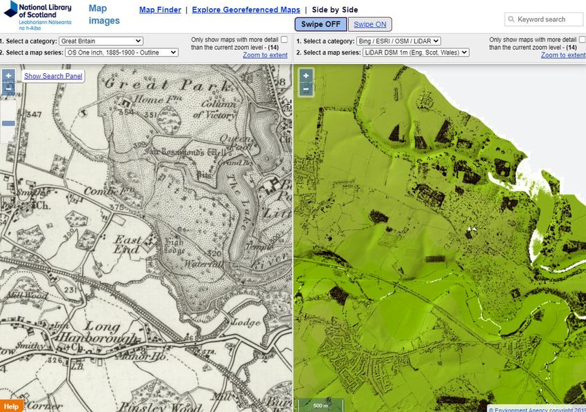
Remote sensing at NT

         • Over 100 remote sensing projects
           in last three years.
         • A strong emphasis on
           archaeology, built heritage and
           landscape.
         • Also used for ecology, habitat
           mapping, faunal survey, etc.
         • Remote Sensing Coordinator role
           (from 2019) to develop NT use of
           RS to support strategic aims.

National Trust is a prolific user of remote
sensing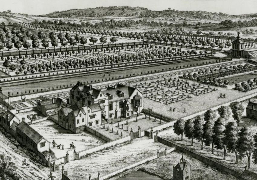
What is Remote Sensing?
What is it?

“Remote sensing is the
science of obtaining the
physical properties of an area
without being there.”
Why does it work?
                                                                     The properties of materials
                                                                     • Most remote sensing depends on the ability to
                                                                       detect variations in the properties of materials.
                                                                     • E.g. texture, colour, density, moisture content,
                                                                       temperature, conductivity, magnetism.
                                                                     • Spectral reflectance – different materials reflect the
                                                                       sun’s energy to a varying degree across the
                                                                       spectrum.
                                                                     • In the visible spectrum we call this their colour!
                                                                     • Beyond visible variations in reflectance may be
                                                                       greater.
                                                                     • If we can distinguish reflectance properties we can
                                                                       distinguish between materials.
                                                                     • If materials have very distinctive reflectance profiles
                                                                       we can identify them.
Visible spectrum
                   The spectral reflection of different materials.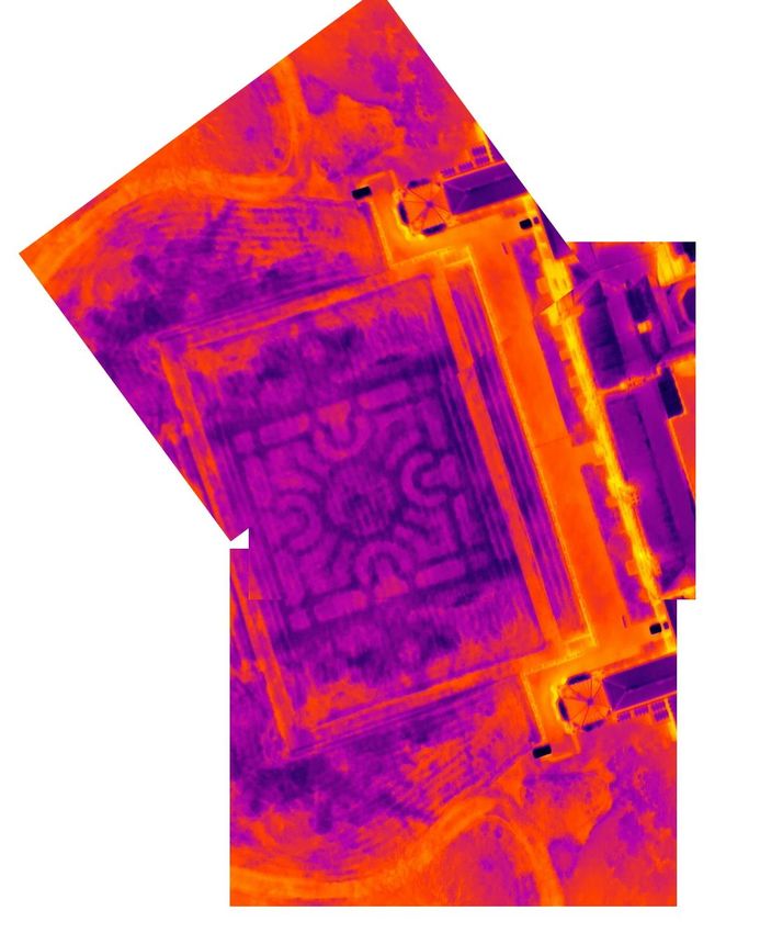
How do we do it?
Sensors, active and passive
• We use sensors to detect material properties.
• A camera is a sensor that detects reflected
  sunlight in the visible spectrum.
• Other sensors can detect beyond the visible
  spectrum.
• Sensors that detect reflected light or emitted heat
  are PASSIVE sensors.
• ACTIVE sensors emit energy and then detect its
  reflectance from a material.
• Example include radar (radio waves), lidar (laser
  light – Light Detection And Ranging) or even sonar
  (sound waves).

                                                        Optech Pegasus ALTM lidar sensor package.
                                                        MicaSense Altum multispectral sensor.
                                                        Proceq GS8000 ground penetrating radar.
How do we do it?
Platforms
• Most sensors can be mounted on a
variety of platforms.
• This might include:
• Orbiting satellites (Satellite Earth
Observation).
• Aircraft (including helicopters and
drones).
• Ground based, on tripods or
carried by an operator.
• Whatever the platform, the sensor
performs essentially the same job of
detection, but at a varying spatial scale.
ESA Sentinel 2A satellite.
Bluesky International Beechcraft King Air C90GTx survey aircraft.
Bartington Instruments Grad 601 fluxgate gradiometer.Designed Landscapes
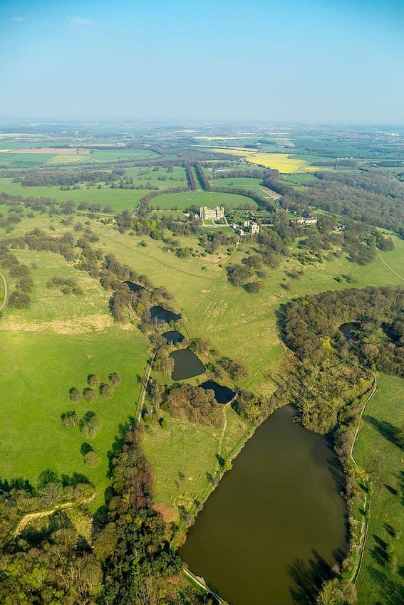
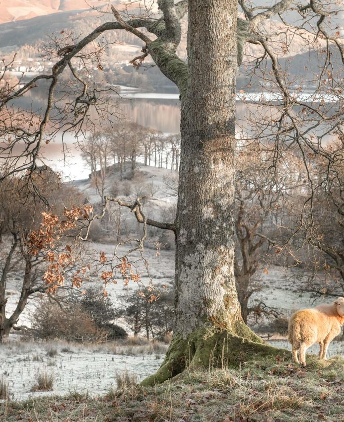
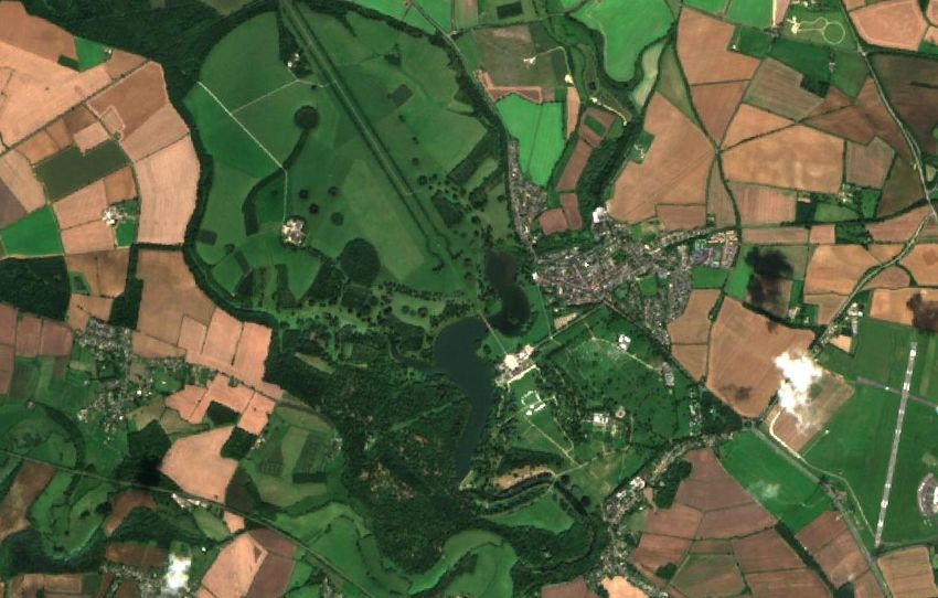
What can we look for?
 • Different remote sensing techniques
   are best suited to looking at
   different aspects of landscape.
 • The broad sweep of designed
   landscapes are best seen from
   above.
 • Garden structures and buildings can
   be photographed and modelled in
   three dimensions.
 • Airborne remote sensing and below
   ground geophysics might detect
   relict features of past garden
   layouts.

A frosty morning at Croome, Worcestershire. The
Parterre Garden at Blickling Estate, Norfolk. The
Eastern Lake Pavilion at Stowe, Buckinghamshire.
View of the Pantheon and lake in October at
Stourhead, Wiltshire. ©National Trust Images
Earthworks and landscape elements
• Many designed landscapes make use of geometric
  forms at scale or substantial earth movement to
  provide views and vistas.
• Aerial photography is great for viewing and
  mapping such features.
• Archaeologists often use air-photography for
  detecting features shown by shadows, crop and
  soils marks – similar principles can be applied to
  designed landscapes.
• Lidar, which produces a three-dimensional record
  of the ground, can help to detect subtle landscape
  modification and large scale earth movement.

Bird's Eye View Of Clandon by Leendert Knyff (1650-1722) in The Green Damask
Room at Clandon Park.
One of four views of the water garden at Studley Royal Water Gardens, North
Yorkshire, by A Walker after Balthazar Nebot (fl 1730-62), coloured mezzotints,
1758.
Relict landscapes

• The fine detail of designed landscapes, such as
  garden features, are often best appreciated
  from above.
• Even if no surface trace survives, the relict
  traces of past garden layouts are sometimes
  visible from the air, or using special airborne
  survey techniques.
• Ground-based geophysics has a good track
  record of detecting and mapping relict garden
  features such as former beds, paths and garden
  buildings.

A bird's eye view of Westbury Court
Garden by Johannes Kip, c. 1707.
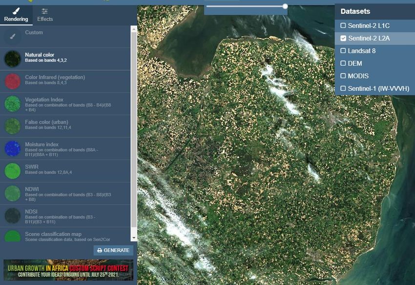
Looking from Space
Does it work?
                                                                     • Satellite imagery is a great way to obtain
                                                                       a broad overview of landscape.
                                                                     • The ESA Sentinel 2 satellites provide full
                                                                       colour (and multispectral) imagery
                                                                       covering most of the UK at 3-5 day
                                                                       intervals.
                                                                     • Sentinel imagery is free to access,
                                                                       download and use.
                                                                     • Other satellite systems offer free data at
                                                                       wider intervals (e.g. Landsat) or pay to
                                                                       use high resolution imagery (e.g.
                                                                       Worldview).
                                                                     • New systems are launched regularly,
                                                                       offering better, higher resolution images.
                                                                     • Using satellite imagery does require
                                                                       specialist software and some technical
                                                                       skill.
Blenheim Park, Oxfordshire. Early 18th century park and gardens by   • Much imagery (such as Sentinel) can be
Vanbrugh and improved by Capability Brown.
Sentinel 2A, 10m true colour composite. 25th August 2017.
                                                                       searched and viewed on-line – no
                                                                       specialist skill required.
What can we see? • You can see pretty much everything visible on a conventional photograph on a satellite image. • Since many systems look beyond the visible spectrum and into the infrared it is often possible to see landscape features either invisible or only faintly visible to the naked eye. • Free imagery such as Sentinel 2, is of limited spatial resolution. • For Sentinel 2 each pixel in the image represents a 10m square on the ground – zoom in and things quickly become fuzzy. • Other free imagery sources tend to have even lower spatial resolution. Blenheim Park. Sentinel 2A, 10m true colour composite. 25th August 2017.
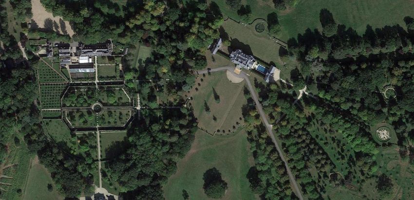
Problems and opportunities
• The greatest problem using satellite imagery in the UK is
  our weather – cloud often obscures the surface – so you
  will need to search for cloud free images.
• The low spatial resolution of free imagery is largely
  overcome by commercial high resolution satellite systems.
• Resolutions of 50cm are typical, with 30cm and below
  becoming the norm – this is getting close to a vertical aerial
  photography – typically 10-20cm.
• Commercial imagery can be bought for small areas (usually
  not less that 25km2) with costs typically about $20/km2.
• High resolution imagery covers a smaller area in each
  image (like looking through a telephoto lens) so it can be
  hard to find images of areas of interest.
• You can pay to “task” a satellite to image your area of
  interest – but you might need a second mortgage for this…

Sentinel 2a Blenheim Park 2nd September 2017 – a cloudy day!
Airbus Industries 50cm Pléiades Satellite Image of Machu Picchu, Peru.
Blenheim Park on Google Earth, showing part of Vanbrugh’s 1730s landscape
design.
Looking from the Air
Aerial photography
                                                                      • Aerial photography has been around for over a
                                                                        century with pioneers, often with military training,
                                                                        working in the period immediately following the
                                                                        First World War.
                                                                      • In England individuals such as OGS Crawford at the
                                                                        Ordnance Survey and Alexander Keiller – the
                                                                        marmalade millionaire – pioneered systematic
                                                                        aerial survey and the archaeological use of air
                                                                        photographs in the 1920s.
                                                                      • Systematic vertical aerial surveys of England were
                                                                        made every decade or so from 1945 to the 1990s.
                                                                      • As a result there are literally tens of millions of
                                                                        archive aerial photographs of the British Isles
                                                                        which provide a rich source of insight into past
                                                                        landscape – many taken at a period before
                                                                        wholesale suburban development or agricultural
                                                                        changes which swept away old parklands.
Fr. Antione Poidebard SOJ (1878 – 1955) in the 1920s in the Levant.
A pioneer of aerial photography.
Aerial photography • Vertical aerial photographs provide a plan view of the landscape. • Like a map they are a great way to appreciate how the various elements of landscape relate to each other. • Often taken from altitude and so fine detail may be hard to see. • Often stereo pairs which give a 3D effect using a stereoscope. • Oblique photographs are the “passenger window” view from an aeroplane. • Very useful for showing in detail the relationship between landscape elements – favoured by archaeologists. • Buried features might be revealed by parchmarks or other vegetation changes. Hardwick Hall, Derbyshire. A largely unimproved Elizabethan deer park with 19 th and early 20th century additions. Vertical and oblique aerial photographs and parchmarks of lost 19th century garden planting (seen from the roof).
Lidar
• Lidar (Light detection and ranging) uses an aircraft mounted
  laser to map the ground surface.
• The laser pulses many thousands of time a second and a mirror
  sweeps the beam across the landscape.
• Measurement of the time the pulse takes to return together
  with GPS coordinates and other flight information create a
  detailed 3D map composed of many millions of points.
• Typical surveys collect 20+ points/m2.
• Individual pulses can be reflected from multiple objects and may
  even pass through vegetation, mapping the surface beneath.
• Raw lidar surveys composed of millions of points require
  significant computer processing to produce images which can be
  interpreted.
• Computer processing can be used to “strip away” vegetation.
• While commissioning a lidar survey can cost many thousands of
  pounds, the Environment Agency has flown most of England and
  Wales with lidar, which is freely available to use.

The lidar principle and lidar profile of woodland.
Type your footnotes here, no smaller
   than 10pt
Buscot Park, Oxfordshire. Late 18th century gardens and pleasure grounds with early 20th century additions by Harold Peto- aerial photography from Google.
Type your footnotes here, no smaller
   than 10pt
Buscot Park, National Trust/Bluesky 25cm resolution lidar surface model.
Type your footnotes here, no smaller
   than 10pt
Buscot Park, lidar “bare earth” model with vegetation removed.
Lidar
• Laxton castle in Nottinghamshire,
  shown using Environment Agency 1m
  resolution lidar.
• Medieval castle earthworks are very
  visible on the ground, on aerial
  photography and lidar.
• The castle grounds were remodelled as
  an early formal garden around a new
  manor house built for the Roos family
  in the 1520s.
• Lidar reveals subtle detail of the
  gardens including boundaries, building
  locations, and ornamental features
  such as a possible parterre, belvedere
  and bowling green.
• All data used here are freely available
  for public use from Google, The
  Bodleian Library and Environment
  Agency.
Laxton, Nottinghamshire. Aerial photography, EA 1m lidar and map of 1635 an
unusual early post-medieval garden making use of a former motte and bailey castle.
Thermal infrared

• Thermal sensors detect the heat emitted by
  objects in the long wave infrared part of the
  spectrum.
• Thermal sensors can be mounted on any platform.
• Thermal images tend to be of lower resolution
  than visible spectrum images.
• Thermal surveys are best undertaken when the
  heat difference between materials are greatest –
  late in the day or at night.
• Because different materials absorb and emit heat
  to a different degree thermal imagery can often
  detect otherwise invisible features below the
  surface.
Crom Castle, County Fermanagh, Northern Ireland. Former garden
parterre adjacent to the early 19th century house by Edward Blore.
Night time TIR image captured by drone survey.
• Drones are small remotely piloted aircraft.
Drone photography
                                                                             • They can be fixed wing or, more often, rotary wing
                                                                               multicopters, which are highly manoeuvrable and provide a
                                                                               stable sensor platform.
                                                                             • Drones can carry many types of sensor, from cameras to
                                                                               multispectral and thermal sensors or even lidar.
                                                                             • One great strength of even simple drones is that
                                                                               conventional digital photographs can be processed using
                                                                               computer based Structure from Motion Photogrammetry
                                                                               to produce 3D data rather like lidar.
                                                                             • Unlike lidar the colour photography allows creation of
                                                                               highly detailed coloured landscape maps and models.

Darnley Mausoleum, Kent, a late 18th century burial place for the Earls of
Darnley by James Wyatt, providing a focus for Humphrey Repton’s later
garden design. Drone photography, 3D point cloud and 3D model.
Looking below the ground
Why it works
                                                                     Properties of buried materials
                                                                     • Geophysical survey largely depends on
                                                                       the ability to distinguish between the
                                                                       different properties of materials below
                                                                       the surface, e.g. density, moisture,
                                                                       magnetism.
                                                                     • Walls are dry, hard and rarely magnetic.
                                                                     • Ditches and pits are often filled with
                                                                       damp, soft, and magnetic material.
                                                                     • Buried roads and paths are usually hard
                                                                       and dry.
                                                                     • Different methods of geophysical survey
                                                                       provide a variety of means to
                                                                       systematically identify and map these
                                                                       differences in material property and so
                                                                       detect things beneath the surface.
An idealised cross section through buried archaeological deposits.
Magnetometry • A magnetometer measures very slight variations in the earth’s magnetic field. • Variations in the magnetic properties of materials, even if they are very slight, effect the broader magnetic field and can be detected and if systematically recorded and mapped can reveal buried features. • Archaeologists often use Fluxgate Gradiometers, a device with two vertically separated magnetometers which measures the gradient of the magnetic field. • Magnetometers are very quick to use and require no contact with the ground. • It’s essential to avoid wearing or using magnetic materials when using magnetometers – for obvious reasons. Belton House, Lincolnshire, early 18th century gardens for Sir John Brownlow by André Le Nôtre revealed in magnetic survey. © Allen Archaeology and National Trust.
Radar
• Radar – usually called ground penetrating radar or GPR
  transmits pulses of electromagnetic energy into the ground
  and measures their reflection or absorption by sub-surface
  features.
• Radar provides two-dimensional time and depth slices
  through the ground.
• Multiple vertical slices can be processed in software to
  produce progressive horizonal slices, rather like peeling
  away layers of the ground.
• Radar is very effective for identifying highly reflective hard
  surfaces.
• Damp or waterlogged ground tends
  to absorb the radar pulse.
• While easy to use in practice,
  radar surveys can be difficult
  to interpret.

GPR survey of garden features at Laxton
castle.
Earth resistance
 • An earth resistance survey measures variations
   in the electrical resistance of the ground using an
   array of stainless steel electrodes.
 • The pattern of resistance variation indicates
   variations in the sub-soil due to its moisture
   retention and/or mineral properties and
   indicates the presence or absence of sub-surface
   features.
 • Most archaeological survey uses a combination
   of fixed and hand-portable probes to inject a
   current into the ground and measure local
   potential voltage. This is converted to resistance
   using Ohms law (I=V/R).
 • Varying the spacing of the portable probes
   changes the depth at which measurements are
   made.
 • Because it’s easy to use, versatile and quite
   forgiving earth resistance survey is often
   favoured by amateur investigators.
Laxton Castle. Resistance survey of garden features in the former
outer bailey.
Geophysical surveys are often complementary. Laxton Castle, L-R, gradiometer,
radar and resistance surveys.
Doing it yourself
Finding resources
• Data that are “born digital” such as lidar and satellite
  imagery are usually discoverable, searchable and often
  downloadable from on-line resources.
• Increasingly older collections of mapping and aerial
  photography are being digitised and are searchable and
  accessible on-line.
• In England Defra provides searchable access to freely
  downloadable EA lidar data (there are similar services for
  Wales, Scotland and to some extent Northern Ireland).
• Don’t ignore unlikely sources. The NCAP hold a digitised
  collection of many thousands of Luftwaffe air photographs
  of the British Isles from the 1940s.
• As an example, Salisbury Hall and Park in Hertfordshire
  were photographed in August 1940 (the earliest known
  aerial photo of the park) probably because the de Havilland
  aircraft design team had been evacuated there!
Defra survey data download portal
https://environment.data.gov.uk/DefraDataDownload
Historic England Britain from above portal http://www.britainfromabove.org.uk
National Collection of Air Photos, German air force photos portal https://ncap.org.uk
Satellite imagery

• Sentinel playground provides free access to
  ESA Sentinel data (and some other systems)
  and a variety of pre-programmed analysis.
• It’s free to use, requires no specialist skills, and
  snapshots of images can be downloaded.
• The data is updated every 2 – 3 days with the
  latest imagery.

                                                         ESA Sentinel Playground: https://apps.sentinel-hub.com/sentinel-playground
Aerial photography
• Google earth is the best source of free aerial photography.
• Historic England and the other UK-nation heritage bodies
maintain archives of many millions of images.
• These can be searched and visited to view photographs
and copies ordered.
• Some collections are available digitally on-line for search
and download or purchase of images.
• Regional record offices and council planning departments
are other good sources of aerial photographs (although
they may deny this!).
• Any systematic use of aerial photography is improved by
getting to grips with some software to assemble and
manage collections of digitised photographs and map from
them.
• Using Geographical information system (GIS) software is
one way to achieve this.
Historic England’s designed landscapes aerial photography resource:
https://services.historicengland.org.uk/designed-landscapes-mapLidar
• Downloading and using lidar can be
complicated and requires special software and
specialist knowledge.
• There are some great, free, on-line resources
for viewing and “tinkering” with lidar.
National Library of Scotland, historic maps, lidar
and aerial imagery: https://maps.nls.uk Houseprices Lidar Lab:
https://houseprices.io/lab/lidar/mapDIY drones • Drones are an affordable and efficiency means of collecting dramatic and useful photography and 3D data. • You need no special qualifications to operate small drones, but you will need a pilot ID and operator ID from CAA and insurance. • There are regulations about where and when you can fly drones and for complex flying and larger drones, training, qualifications and CAA certification is required, even for non professionals. • Working with drone photography requires specialist software, which can be complex and requires patience to master. • There are several free software tools which provide most of the functions needed to fly and operate drones and process drone photography. SNAPTAIN SP500 - more of a toy, but less than £100 with a 4k camera. DJI Mavic Mini Combo, entry level enthusiast drone with a 12mp camera for £360.
DIY geophysics
• Buying geophysical survey equipment is probably not
  realistic as even simple systems cost thousands of pounds.
• It is possible to hire survey equipment commercially.
• Resistivity survey is the best place to start as the
  equipment is relatively easy to use, versatile and provides
  reasonable results in most garden settings.
• If you are ambitious and technically adept you could build
  your own resistivity meter – Google for it!
• Soil moisture meters can be a good proxy for resistivity
  survey. Take readings systematically on a grid and digitise
  the results to create maps.
• Professional systems are expensive, but many gardens will
  have access to these.
• Cheaper resistive soil moisture sensors require some
  technical expertise and connection to a small computer
  such as a Raspberry Pi for use.

Geoscan Research RM85 Resistivity Meter.
Delta-T Devices SM150 Soil Moisture Sensor, about £500.
Icstation Resistive Soil Moisture Sensor, £35 and Raspberry Pi 3, £40.
Do…try this at home

Survey and geophysics of 16th century garden
features at Laxton castle.
Resources                                 Lidar                                    Geophysics
                                          Defra Survey Data Download:              Geoscan Research: http://www.geoscan-
Satellite Imagery
                                          https://environment.data.gov.uk/DefraD   research.co.uk
ESA Copernicus Open Access Hub:           ataDownload                              Bartington Instruments:
https://scihub.copernicus.eu/dhus
                                          Lle – Welsh Government Geo-portal:       https://www.bartington.com
(requires registration)
                                          https://lle.gov.wales/home               Allied Associates: https://www.allied-
Sentinel Playground:
                                          Scottish Remote Sensing Portal:          associates.com
https://apps.sentinel-hub.com/sentinel-
                                          https://remotesensingdata.gov.scot
playground                                                                         Computer Software
                                          National Library of Scotland Maps
USGS Earth Explorer:                                                               QGIS – Free GIS for working with satellite
                                          (including lidar): https://maps.nls.uk
https://earthexplorer.usgs.gov                                                     imagery, lidar and other digital data:
                                          Houseprices.io Lidar Lab:                https://www.qgis.org
Google Earth:
                                          https://houseprices.io/lab/lidar/map
https://earth.google.com/web                                                       Quick Terrain Reader – For viewing lidar
                                                                                   point clouds: https://appliedimagery.com
Aerial Photography
                                                                                   Snuffler - Free Geophysics Software:
Historic England – National Air Photo
                                                                                   http://www.sussexarch.org.uk/geophys/s
Library:
                                                                                   nuffler.html
https://historicengland.org.uk/images-
books/archive/collections/aerial-photos                                            Open Drone Map for mapping and
                                                                                   modelling from drone photography:
NCAP: https://ncap.org.uk
                                                                                   https://www.opendronemap.org
If you have any questions feel free to contact me. Keith.Challis@nationaltrust.org.uk Images © National Trust Images unless stated. © National Trust 2021 Registered charity no. 205846
You can also read