VEGETATION ASSESSMENT - LOT 6 OCEAN VIEW DRIVE, WEST NARRAWONG PREPARED FOR: MYERS PLANNING GROUP - Glenelg Shire Council
←
→
Page content transcription
If your browser does not render page correctly, please read the page content below

VEGETATION
ASSESSMENT
LOT 6 OCEAN VIEW DRIVE, WEST NARRAWONG
PREPARED FOR: MYERS PLANNING GROUP
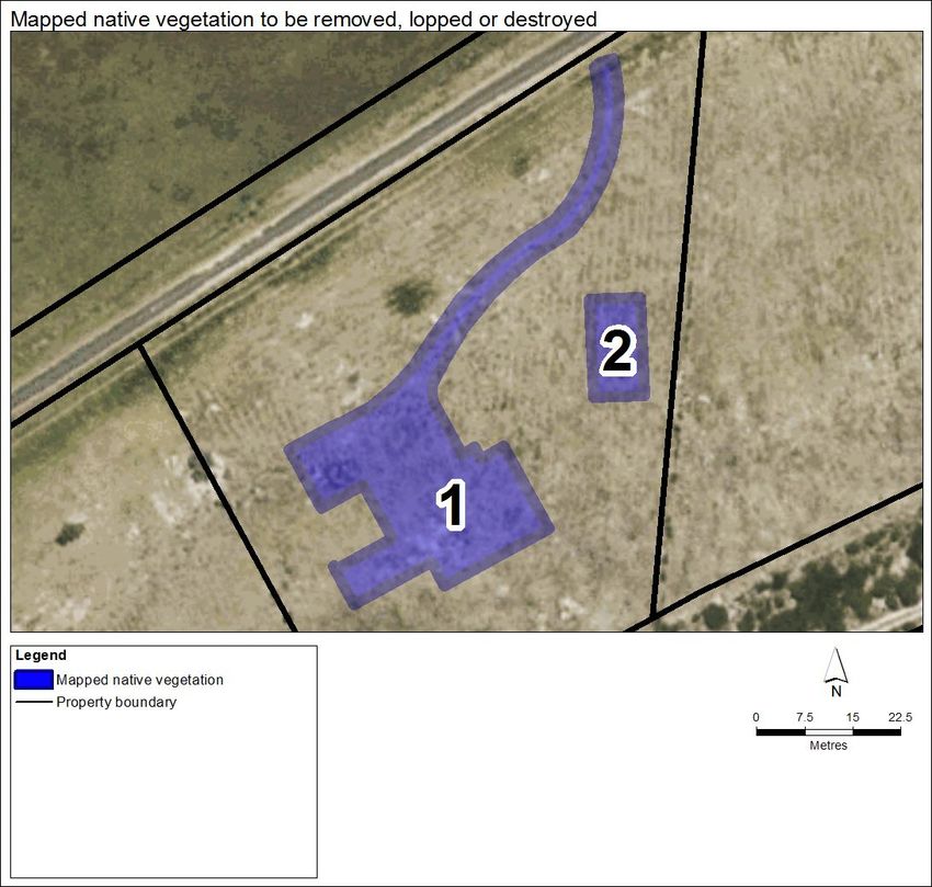
Table of Contents

Document Information                                                          3
Summary                                                                      4
1     Introduction                                                            5
      1.1 Project Background                                                  5
      1.2      Objectives                                                     5
      1.3      Site Description                                               5
    Figure 1 – Site Location                                                  7
2     Methodology                                                             8
      2.1    Species Information                                              8
      2.2    Desktop Assessment                                               8
      2.3    Field Assessment                                                 8
      2.4    Assessment Guidelines                                            9
      2.5    Limitations                                                     10
3     Results                                                                11
      3.1     Ecological Vegetation Classes                                  11
      3.2     Vegetation Condition                                           11
      3.3     Threatened Flora Species                                       11
      3.4     Threatened Fauna Species                                       12
      3.5     Threatened Ecological Communities                              12
    Figure 2 – Ecological Values                                             15
4     Environmental Legislation and Policy Implications                      16
      4.1    Environment Protection and Biodiversity Conservation Act 1999   16
      4.2    Flora and Fauna Guarantee Act 1988                              16
      4.3    Planning and Environment Act 1987                               16
5     Conclusion                                                             23
6     References                                                             24
Appendices                                                                   25
    Appendix 1 – Likelihood of Occurrence                                    25
    Appendix 2 – Flora Species Recorded                                      26
    Appendix 3 – Threatened Flora Records                                    27
    Appendix 4 – Threatened Fauna Records                                    28
    Appendix 5 – Native Vegetation Removal Application                       30

M782_WestNarrawong_Vegetation_Assessment_Report_25022021_V1                   2
Document Information

Vegetation assessment for the property at Lot 6 Ocean View Drive, West Narrawong

Report prepared by Okologie Consulting Pty Ltd for Myers Planning Group

Okologie Consulting Pty Ltd
32 Nicholson Crescent
Jan Juc, Victoria, 3228

ACN: 618 785 336
Web: www.okologie.com.au
Email: mark@okologie.com.au
Phone: 0419 786 533

Document Control
        Version                           Review                  Author                   Approval                     Date
M782_WestNarrawong_
Vegetation_Assessment                  Luke Hynes           Mark Stockdale                                        25/02/2021
_Report_25022021_V1

Acknowledgements
Okologie Consulting acknowledges the following people in their contribution to this
project:

     •    Dan Pech (Myers Planning Group) for project information.

                                                    © Okologie Consulting
This document was prepared for the sole use of the party identified on the cover sheet and may only be used for the purposes for
which it was commissioned in accordance with the Terms of the Engagement. This document is subject to copyright and no
section or element of this document may be removed, reproduced, electronically stored or transmitted in any form without the
prior written permission of Okologie Consulting.

                                                              Disclaimer
Okologie Consulting has taken all necessary steps to ensure that an accurate document has been prepared in accordance with
relevant legislation and current industry best practice. Okologie Consulting accepts no liability for any damages or loss incurred
as a result of reliance placed upon the report content or for any purpose other than that for which it was intended.

M782_WestNarrawong_Vegetation_Assessment_Report_25022021_V1                                                                     3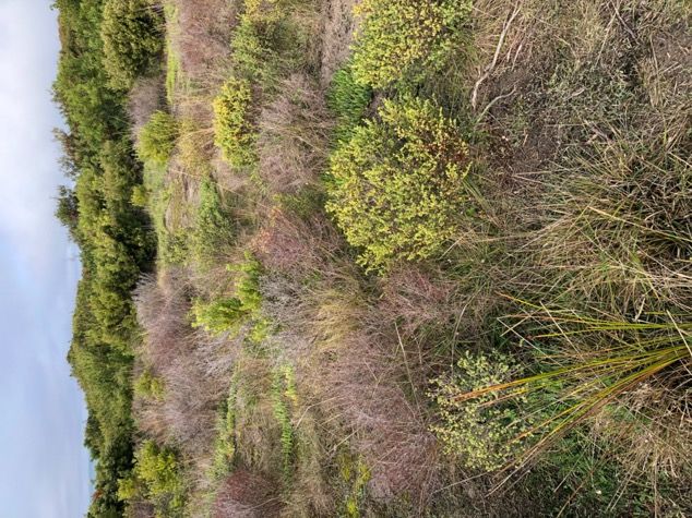
Summary
Okologie Consulting Pty Ltd was engaged by Myers Planning Group to undertake a
vegetation assessment for Lot 6 Ocean View Drive, West Narrawong.

The development proposal is for construction of a single residential dwelling. The
vegetation assessment was undertaken to determine the extent of native vegetation
for removal and ascertain the presence of any threatened flora or fauna species or
associated habitats.

The project area was characterised by a modified cover of Coastal Dune Scrub,
interspersed with exotic dominated vegetation. The quality and extent of native
vegetation varied across the property as a result of previous disturbance. The northern
section of the site was of lower quality from historic agricultural use and land
clearing, whereas southern section comprised a relatively intact cover of Coastal Dune
Scrub that was contiguous with the Narrawong Coastal Reserve.

No listed threatened flora or fauna species or associated habitats were recorded the
field assessment, and none are considered likely to occur due to the absence of
suitable habitat. An Environment Protection Biodiversity Conservation Act 1999
referral to the Commonwealth Environment Minister is not required as no Matters of
National Environmental Significance are present or likely to be significantly impacted
by future works in the project area.

The proposed design indicates the development will require the removal of 0.103
hectares of Coastal Dune Scrub. The effluent system and access track are located in
modified areas of native vegetation in the northern section. The dwelling is located in
the northern section and partially in the southern section of higher quality vegetation.
There are no feasible opportunities to further avoid removal or minimise impacts to
native vegetation without compromising the proposed development plan.

The proposed removal of 0.103 hectares of native vegetation requires a permit under
Clause 52.17 (Native Vegetation) of the Glenelg Planning Scheme. A basic assessment
pathway application has been prepared to meet the requirements of the Guidelines for
the removal, destruction or lopping of native vegetation.

The native vegetation removal report identified a general offset of 0.048 general
habitat units is required. The general offset must have a minimum strategic
biodiversity value score of 0.258 and be within the Glenelg Hopkins Catchment
Management Authority or Glenelg Shire Council.

The required offset will be secured as an allocated credit extract (third party offset)
through the Native Vegetation Credit Register. Evidence of offset availability has been
provided.

M782_WestNarrawong_Vegetation_Assessment_Report_25022021_V1                           4

1 Introduction

1.1       Project Background

Okologie Consulting Pty Ltd was engaged by Myers Planning Group to prepare a
vegetation assessment for the property at Lot 6 Ocean View Drive, West Narrawong.

The development proposal is for construction of a single residential dwelling. The
vegetation assessment was undertaken to determine the extent of native vegetation
for removal and ascertain the presence of any threatened flora or fauna species or
associated habitats.

The proposed removal of native vegetation requires a permit under Clause 52.17
(Native Vegetation) of the Glenelg Planning Scheme and an application under the
Guidelines for the removal, destruction or lopping of native vegetation (the Guidelines)
(DELWP 2017).

The property was subject to planning permit approval TP250/03 associated with a
nine-lot subdivision that has since expired. A preliminary flora and fauna assessment
was completed of part of a revised permit application to Glenelg Shire Council in 2009
(GHD 2009). Amendment C93 (4 October 2012) granted planning approval for the use
and development of the site, subject to works commencing by September 2016.

This report details the findings of the vegetation assessment and discusses
environmental legislation and policy implications associated with the proposed
development.

1.2       Objectives

The objectives of the assessment were to:

      •    Assess terrestrial ecological values (i.e. vegetation communities, flora and fauna
           species and associated habitats) within the project area.
      •    Address the application requirements under Clause 52.17 and the Guidelines.
      •    Ensure ecological values are identified in the early planning phase.
      •    Identify environmental legislation and policy requirements.

1.3       Site Description

The project area comprises the property at Lot 6 Ocean View Drive, West Narrawong
(PS522386) (Figure 1). The property covers approximately 0.6 hectares and is bound by
Ocean View Drive to the north, private property to the east and west, and Narrawong
Coastal Reserve (Crown Reserve 0304479) to the south.

M782_WestNarrawong_Vegetation_Assessment_Report_25022021_V1                                5
The project area is located on the secondary and tertiary dune system. The topography
comprises low to moderate undulating slopes towards the north. The project area and
adjacent residential lots have been subject to previous disturbance (agricultural use,
land clearing). The surrounding land use consists of agriculture, semi-rural
development and conservation (Narrawong Coastal Reserve).

The project area occurs within the Warrnambool Plain bioregion, the Glenelg Hopkins
Catchment Management Authority boundary and the Glenelg Shire municipality
(DELWP 2021a). The Native Vegetation Location mapping shows the project area
occurs within Location 1 (DELWP 2021b). The project area is zoned Rural Living Zone
and is partially subject to Environmental Significance Overlay – Schedule 1 (ESO1)
under the Glenelg Planning Scheme (DELWP 2021c).

M782_WestNarrawong_Vegetation_Assessment_Report_25022021_V1                         6

Figure 1
 Site Location
 Lot 6 Ocean View Dr,
 West Narrawong

 Legend
                                                                                                   W
                                                                                            IV E
              Subject Site                                                            W
                                                                                          DR
                                                                             N   V IE
                                                                           EA
                                                                         OC

                                      MELBOURNE

       PORTLAND

              0        5        10                 20

                           Metres
           Coordinate System: GDA 1994 MGA Zone 55
           Map Scale when printed @ A4 1:700

VicMap Data: The state of Victoria does not warrant the accuracy or
correctness of information in this publication and any person using or
relying upon such informationdoes so on the basis that the State of
Victoria shall bear no responsibilty or liability whatsoever for any                                   Source: Esri, DigitalGlobe, GeoEye, Earthstar Geographics, CNES/Airbus DS, USDA,
errors, faults, defects or omissions in the information.                                               USGS, AeroGRID, IGN, and the GIS User Community
2 Methodology

2.1       Species Information

Scientific and common names of flora species and terrestrial vertebrate fauna species
follow the Victorian Biodiversity Atlas (VBA) (DELWP 2021d). Vegetation communities
follow the Ecological Vegetation Class (EVC) bioregion benchmarks (DELWP 2021a).

Native flora and fauna referred to as ‘threatened’ include species:

      •    Listed as critically endangered, endangered or vulnerable under the
           Environment Protection Biodiversity Conservation Act 1999 (EPBC Act) (DAWE
           2021).
      •    Listed as threatened under the Flora and Fauna Guarantee Act 1988 (FFG Act)
           (DELWP 2021e).
      •    Listed as critically endangered, endangered, vulnerable or rare on Victoria’s
           rare or threatened flora and fauna advisory lists (DEPI 2014; DSE 2013).

2.2       Desktop Assessment

A desktop assessment was undertaken of relevant databases and other resources,
including:

      •    NatureKit for modelled biodiversity data (DELWP 2021a).
      •    Native Vegetation Information Management system tool for native vegetation
           information (DELWP 2021b).
      •    Planning Schemes Online for planning information (DELWP 2021c).
      •    The VBA for threatened flora and fauna species records (DELWP 2021d).
      •    The Protected Matters Search Tool (PMST) for information relating to Matters
           of National Environmental Significance (MNES) (listed species and
           communities) under the EPBC Act (DAWE 2021).
      •    Relevant environmental legislation, policies and strategies.

2.3       Field Assessment

The vegetation assessment was undertaken on 4 February 2021. The project area was
traversed on foot to determine the extent of native vegetation and ascertain the
presence of any listed threatened flora or fauna species or associated habitats. The
extent of native vegetation was mapped using a Trimble Catalyst DA1 differential GPS
(sub-metre accuracy post-processing) and recorded to MGA 94, Zone 55 coordinate
system. EVCs were determined by reference to the relevant bioregion mapping and
benchmarks descriptions (DELWP 2021a), and review of remnant vegetation in the
local area.

M782_WestNarrawong_Vegetation_Assessment_Report_25022021_V1                           8
2.4       Assessment Guidelines

The Guidelines (DELWP 2017) has been incorporated into the Victoria Planning
Provisions and all planning schemes in Victoria. The purpose of the Guidelines is to set
out and describe the application of Victoria’s statewide policy in relation to assessing
and compensating for the removal of native vegetation in response to permit
applications under Clause 52.17.

Native vegetation is defined in Clause 72 of the Victoria Planning Provisions as plants
that are indigenous to Victoria, including trees, shrubs, herbs and grasses. Plants from
other states or overseas are not native and the permitted clearing regulations do not
apply if they are being removed (DELWP 2017).

The Guidelines considers the biodiversity value of native vegetation by measuring the
following two components:

      •    Site-based information that can be measured or observed at a site.
      •    Landscape scale information that cannot be measured or observed at the site
           and is included in maps and models (DELWP 2017).

Under the Guidelines native vegetation is classified as a patch or scattered tree.

A patch of native vegetation is:

      •An area of vegetation where at least 25 per cent of the total perennial
       understorey plant cover is native1; or
   • Any area with three or more native canopy trees2 where the drip line3 of each
       tree touches the drip line of at least one other tree, forming a continuous
       canopy; or
   • Any mapped wetland included in the Current wetlands map.
A scattered tree is:

      •    A native canopy tree that does not form part of a patch (DELWP 2017).

The assessment pathway for an application to remove native vegetation reflects its
potential impact on biodiversity and is determined from the location and extent of the
native vegetation to be removed.

1
  Plant cover is the proportion of the ground that is shaded by vegetation foliage when lit from directly above. Areas that include
non-vascular vegetation (such as mosses and lichens) but otherwise support no native vascular vegetation are not considered to
be a patch for the purposes of the Guidelines. However, when non-vascular vegetation is present with vascular vegetation, it does
contribute to cover when determining the percentage of perennial understorey plant cover.
2
  A native canopy tree is a mature tree (i.e. it is able to flower) that is greater than 3 metres in height and is normally found in the
upper layer of the relevant vegetation type.
3
  The drip line is the outermost boundary of a tree canopy (leaves and/or branches) where the water drips on to the ground
(DELWP 2017).

M782_WestNarrawong_Vegetation_Assessment_Report_25022021_V1                                                                            9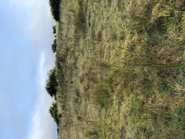
The three assessment pathways are:

      •    Basic – limited impacts on biodiversity.
      •    Intermediate – could impact on large trees, endangered EVCs, and sensitive
           wetlands and coastal areas.
      •    Detailed – could impact on large trees, endangered EVCs, sensitive wetlands
           and coastal areas, and could significantly impact on habitat for rare or
           threatened species.

The assessment pathway of an application is determined in accordance with the
requirements in Table 2.

Table 2: Assessment pathways
                                                                            Location Category
                Extent of native vegetation
                                                               Location 1       Location 2    Location 3

Less than 0.5 hectares and not including any large trees          Basic        Intermediate     Detailed

Less than 0.5 hectares and including one or more large trees   Intermediate    Intermediate     Detailed

0.5 hectares or more                                             Detailed        Detailed       Detailed
Source: DELWP (2017).

2.5       Limitations

The preferred survey period for undertaking vegetation assessments in Victoria is
spring, which maximises the likelihood of detecting all flora species within a site.
Flora surveys provide a valuable ‘snapshot’ of vegetation at a point in time; however,
the limitations of seasonal influence (summer) on the presence/absence of flora
species (particularly annuals or cryptic species) must be considered. The short
duration of the assessment limited the opportunity to observe migratory, transitory or
uncommon fauna species.

The information outlined in this report relies on the accuracy of ecological database
information, GIS layers and spatial imagery. To minimise potential errors, the most
current available data was obtained from relevant sources.

The Department of Environment, Land, Water and Planning (DELWP) bioregion and
EVC mapping are subject to inherently broad environmental and ecological
parameters used in the mapping process. Where the observed EVC was not reflective
of what would be expected from EVC mapping and classification, it was attributed to
the most appropriate EVC based on combination of its floristic, life form and
ecological characteristics, and particular environmental conditions.

M782_WestNarrawong_Vegetation_Assessment_Report_25022021_V1                                                10
3 Results 3.1 Ecological Vegetation Classes NatureKit modelling identifies the pre-1750 EVC mapping for the project area would have predominantly comprised of Coastal Dune Scrub (EVC 160), with Freshwater Meadow (EVC 680) and Swamp Scrub (EVC 53) in the immediate surrounds. Extant (2005) EVC mapping shows a sparse cover of Coastal Dune Scrub (DELWP 2021a). Remnant vegetation within the project area was attributed to Coastal Dune Scrub based on floristic, life form and ecological characteristics (Figure 2). 3.2 Vegetation Condition The project area was characterised by a modified cover of Coastal Dune Scrub, interspersed with exotic dominated vegetation. The quality and extent of native vegetation varied across the property as a result of previous disturbance. The northern section of the site was of lower quality from historic agricultural use and land clearing, whereas southern section comprised a relatively intact cover of Coastal Dune Scrub that was contiguous with the Narrawong Coastal Reserve (Figure 2). Coastal Dune Scrub in the southern section was dominated by Coast Wattle Acacia longifolia subsp. sophorae to three metres tall, with Coast Beard-heath Leucopogon parviflorus, Thyme Rice-flower Pimelea serpyllifolia subsp. serpyllifolia, Seaberry Saltbush Chenopodium candolleanum also present in the shrub layer. The ground layer consisted of Coast Tussock-grass Poa poiformis, Bent Reed-grass Deyeuxia quadriseta, Coast Sword-sedge Lepidosperma gladiatum, Knobby Club-sedge Ficinia nodosa, Karkalla Carpobrotus rossii, Coast Swainson-pea Swainsona lessertiifolia and Bower Spinach Tetragonia implexicoma. Exotic species included Marram Grass Ammophila arenaria, Hare’s-tail Grass Lagurus ovatus, Yorkshire Fog-grass Holcus lanatus, Panic Veldt-grass Ehrharta erecta and Paspalum Paspalum dilatatum (identified as Habitat Zone 1) (Plates 1 to 4). The northern section supported a highly modified cover of Coastal Dune Scrub, consisting of Coast Wattle, Coast Beard-heath, Thyme Rice-flower, Coast Tussock- grass, Bent Reed-grass, Knobby Club-sedge and Bidgee-widgee Acaena novae-zelandiae, interspersed with exotic Cocksfoot Dactylis glomerata, Kikuyu Cenchrus clandestinus, Perennial Ryegrass Lolium perenne, Marram Grass, Paspalum, Hare’s-tail Grass, Ribwort Plantago lanceolata and Sow Thistle Sonchus oleraceus (identified as Habitat Zone 2) (Plates 5 to 8). 3.3 Threatened Flora Species M782_WestNarrawong_Vegetation_Assessment_Report_25022021_V1 11
The VBA (DELWP 2021d) contains records of eight listed threatened flora species in
local area (within a five-kilometre radius of the project area). The PMST (DAWE 2021)
identified 11 EPBC Act listed flora species or species habitats as likely to occur within
the local area (Appendix 3).

No listed threatened flora species were recorded during the field assessment. There is
a low likelihood of occurrence for any listed threatened flora species as the project
area has been modified from historic agricultural use and disturbance from slashing,
which reduces or eliminates the habitat potential for many species.

3.4       Threatened Fauna Species

The VBA (DELWP 2021d) contains records of 22 listed threatened fauna species in the
local area. The PMST (DAWE 2021) identified 45 EPBC Act listed fauna species or
species habitats (terrestrial) as likely to occur within the local area (Appendix 4).

No listed threatened fauna species were recorded during the field assessment. There is
a low likelihood of occurrence for any listed threatened fauna species due to the
absence of suitable habitat. The project area has been modified from historic
agricultural use, which limits habitat availability to generalist species adapted to
modified habitats.

3.5       Threatened Ecological Communities

Commonwealth Listed Ecological Communities

Review of the PMST (DAWE 2021) identified three EPBC Act listed ecological
communities may or are known to occur within the local area:

      •    Grassy Eucalypt Woodland of the Victorian Volcanic Plain (Critically
           Endangered).
      •    Natural Temperate Grassland of the Victorian Volcanic Plain (Critically
           Endangered).
      •    Assemblages of species associated with open-coast salt-wedge estuaries of
           western and central Victoria ecological community (Critically Endangered).

Native vegetation within the project area does not meet the criteria or condition
thresholds for any EPBC Act listed ecological communities.

3.6       Native Vegetation Proposed for Removal

The project design indicates the works associated with development of the site will
require the removal of 0.103 hectares of Coastal Dune Scrub (Plates 3 to 8) (Figure 2).

M782_WestNarrawong_Vegetation_Assessment_Report_25022021_V1                           12
Plate 1: Coastal Dune Scrub for retention - southern section Plate 2: Coastal Dune Scrub for retention - southern section Plate 3: Coastal Dune Scrub for partial removal southern section Plate 4: Coastal Dune Scrub for partial removal southern section M782_WestNarrawong_Vegetation_Assessment_Report_25022021_V1 13
Plate 5: Modified Coastal Dune Scrub for removal   Plate 6: Modified Coastal Dune Scrub for removal

Plate 7: Modified Coastal Dune Scrub for removal   Plate 8: Modified Coastal Dune Scrub for removal

M782_WestNarrawong_Vegetation_Assessment_Report_25022021_V1                                           14
Figure 2
 Ecological Features
 Lot 6 Ocean View Dr,
 West Narrawong

 Legend
                                                                                                   W
                                                                                            IV E
              Subject Site                                                            W
                                                                                          DR
                                                                             N   V IE
                                                                           EA
              Coastal Dune Scrub                                         OC

              Predominantly
              Introduced
              Vegetation
              Vegetation for
              Removal

                                      MELBOURNE

       PORTLAND

              0        5        10                 20

                           Metres
           Coordinate System: GDA 1994 MGA Zone 55
           Map Scale when printed @ A4 1:700

VicMap Data: The state of Victoria does not warrant the accuracy or
correctness of information in this publication and any person using or
relying upon such informationdoes so on the basis that the State of
Victoria shall bear no responsibilty or liability whatsoever for any                                   Source: Esri, DigitalGlobe, GeoEye, Earthstar Geographics, CNES/Airbus DS, USDA,
errors, faults, defects or omissions in the information.                                               USGS, AeroGRID, IGN, and the GIS User Community
4 Environmental Legislation and Policy Implications 4.1 Environment Protection and Biodiversity Conservation Act 1999 The EPBC Act provides a process for assessment of proposed actions that may have a significant impact on a MNES, which includes EPBC Act listed flora, fauna and ecological communities (DoE 2013). The EPBC Act affects any group or individual (including companies) whose actions (i.e. proposal or project) are assessed for environmental impacts under the EPBC Act. An action requires approval from the Commonwealth Environment Minister if it is considered likely to have a significant impact on a MNES (DoE 2013). No EPBC Act listed threatened ecological communities or flora, or fauna species were recorded within the project area, and none are considered likely to occur due to the absence of suitable habitat. An EPBC Act referral to the Commonwealth Environment Minister is not required as no MNES are present or likely to be significantly impacted by future works in the project area. 4.2 Flora and Fauna Guarantee Act 1988 The FFG Act is the key Victorian legislation for the conservation of threatened species and communities and for the management of potentially threatening processes. A permit is required from DELWP to 'take' (kill, injure, disturb or collect) listed flora species, flora species that are members of listed threatened communities or protected flora from public land. Protected flora species includes all members of the following plant families Asteraceae (Daisies), Epacridaceae (Heaths) and Orchidaceae (Orchids), all clubmosses, ferns and fern allies (excluding Pteridium esculentum). All species of the following genera are also protected: Acacia (excluding Acacia dealbata, Acacia decurrens, Acacia implexa, Acacia melanoxylon and Acacia paradoxa), Baeckea, Calytrix, Correa, Darwinia, Eremophila, Eriostemon, Gompholobium, Grevillea, Prostanthera, Sphagnum, Thryptomene, Thysanotus and Xanthorrhoea (DELWP 2021e). Two FFG Act listed protected flora species (Coastal Wattle and Coast Beard-heath) occur within the project area. However, an FFG Act permit is generally not required for private land. 4.3 Planning and Environment Act 1987 The purpose of the Planning and Environment Act 1987 is to establish a framework for planning the use, development and protection of land in Victoria. Native M782_WestNarrawong_Vegetation_Assessment_Report_25022021_V1 16
vegetation clearance is managed under the Act and through municipal planning
schemes (DELWP 2021c).

A permit is required under Clause 52.17 (Native Vegetation) to remove, destroy or lop
native vegetation, including dead vegetation, unless the action is exempt. To ensure
that there is no net loss to biodiversity as a result of the removal, destruction or
lopping of native vegetation, the following three step approach is applied in
accordance with the Guidelines:

   1. Avoid the removal, destruction or lopping of native vegetation.
   2. Minimise impacts from the removal, destruction or lopping of native
      vegetation that cannot be avoided.
   3. Provide an offset to compensate for the biodiversity impact if a permit is
      granted to remove, destroy or lop native vegetation.

If native vegetation removal is required, a permit application must be categorised as a
basic, intermediate or detailed assessment pathway as specified in the Guidelines
(DELWP 2017). Each assessment pathway has specific application requirements and
decision guidelines that must be considered by the responsible authority.

Clause 66 (Referral and Notice Provisions) requires that the following applications to
remove native vegetation be referred to the Secretary to DELWP:

   •   To remove, destroy or lop native vegetation in the Detailed Assessment
       Pathway
   •   To remove, destroy or lop native vegetation if a Property Vegetation Plan
       applies to the site.
   •   To remove, destroy or lop native vegetation on Crown land, which is occupied
       or managed by the responsible authority (DELWP 2021c).

Clause 52.17 – Native Vegetation

The project area was characterised by a modified cover of Coastal Dune Scrub,
interspersed with exotic dominated vegetation. Two separate habitat zones were
identified within the project area, where the quality and extent of native species cover
varied from previous disturbance.

The project design indicates the works associated with development will require the
removal of 0.103 hectares of Coastal Dune Scrub (Plates 3 to 8) (Figure 2). The siting
and location of the dwelling, effluent system and access track are located in the
central section of the property. This location was informed by the Climate Change
Management Plan (Eco-tainable 2021a), which assessed potential sea level rise and
climate change impacts, erosion potential, and the Land Capability Assessment (Eco-
tainable 2021b) that considers the capability of the land to support a wastewater
disposal system.

M782_WestNarrawong_Vegetation_Assessment_Report_25022021_V1                          17
The siting of the development works has considered the impact on native vegetation. The effluent system and access track are located in modified areas of native vegetation in the northern section. The dwelling is located in the northern section and partially in the southern section of higher quality vegetation. The siting of the dwelling was constrained by issues identified in the Climate Change Management Plan (Eco-tainable 2021a). There are no feasible opportunities to further avoid removal or minimise impacts to native vegetation without compromising the proposed access design and development plan. The proposed removal of 0.103 hectares of native vegetation requires a permit under Clause 52.17 (Native Vegetation) of the Glenelg Planning Scheme (DELWP 2021c). The native vegetation removal report (Appendix 5) (DELWP 2021e) identified a basic assessment pathway application is required in accordance with the Guidelines (DELWP 2017) (Table 3). Environmental Significance Overlay – Schedule 1 The project area is partially subject to ESO1 (Coastal Areas) under the Glenelg Planning Scheme (DELWP 2021c). A permit will not be required under ESO1 in this instance, as the proposed development occurs outside the ESO1 overlay. M782_WestNarrawong_Vegetation_Assessment_Report_25022021_V1 18
Table 3: Basic assessment pathway application
Number    Application Requirement                               Response

1.        The assessment pathway and reason                     The       application     is    under    the        basic
          for       the    assessment         pathway.   This   assessment pathway as the vegetation
          includes the location category of the                 removal         occurs    in     Location      1.    The
          native vegetation to be removed.                      assessment pathway is for construction of
                                                                a dwelling, provision of an effluent system
                                                                and an access track, which requires the
                                                                removal of native vegetation. The location
                                                                of native vegetation for removal is shown
                                                                on Figure 2.

          A description of the native vegetation to                   •    The native vegetation proposed for
          be removed that includes:                                        removal is classified as a patch
                •     Whether it is a patch or a                           under the Guidelines.
                      scattered tree (or both).                       •    The extent of the patch of native
                •     The extent (in hectares).                            vegetation (Coastal Dune Scrub)
                                                                           covers 0.103 hectares.
                •     The number and circumference
                      (in centimetres measured at 1.3                 •    No large trees in a patch require
                      metres above ground level) of                        removal.
                      any large trees within a patch.                 •    No     scattered      indigenous         trees
                •     The number and circumference                         require removal.
                      (in centimetres measured at 1.3                 •    The    strategic      biodiversity       value
                      metres above ground level) of                        score of all mapped vegetation is
                      any        scattered      trees,   and               0.323.
                      whether each tree is small or                   •    The condition score of all mapped
                      large.                                               vegetation is 0.472.
                •     The strategic biodiversity value                •    Coastal Dune Scrub is listed as
                      score                                                Depleted in the Warrnambool Plain
                •     The condition score.                                 bioregion.
                •     If    it     includes     endangered            •    The project area does not include
                      Ecological Vegetation Classes.                       any sensitive wetland areas. It
                •     If it includes sensitive wetland or                  occurs in a coastal area contiguous
                      coastal areas.                                       with     the        Narrawong       Coastal
                                                                           Reserve.

          Maps showing the native vegetation and                      •    The location of native vegetation
          property in context and containing:                              for removal is shown on Figure 2.
                •     Scale, north point and property                 •    No large trees in a patch require

M782_WestNarrawong_Vegetation_Assessment_Report_25022021_V1                                                           19
Number Application Requirement Response
boundaries. removal.
• Location of any patches of • No scattered indigenous trees
native vegetation and the require removal.
number of large trees within the
patch proposed to be removed.
• Location of scattered trees
proposed to be removed,
including their size.
The offset requirement, determined in The offset requirement is for a general
accordance with section 5 of the offset amount of 0.048 general habitat
Guidelines, that will apply if the native units. The general offset must have a
vegetation is approved to be removed minimum strategic biodiversity value score
of 0.258 and be within the Glenelg Hopkins
CMA or Glenelg Shire Council.
2. Topographic and land information The topography comprises low to
relating to the native vegetation to be moderate undulating slopes towards the
removed, showing ridges, crests and north. It does not contain any wetlands or
hilltops, wetlands and waterways, slopes waterways, ridges or hilltops, steep slopes,
of more than 20 percent, drainage lines, low lying areas, saline discharge areas or
low lying areas, saline discharge areas, any areas of existing erosion.
and areas of existing erosion, as
appropriate. This may be represented in
a map or plan.
3. Recent photographs of the native Photographs of native vegetation assumed
vegetation to be removed. lost are shown on Pages 13 and 14.
4. Details of any other native vegetation No permitted removal of other native
approved to be removed, or that was vegetation has been undertaken on the
removed without the required same contiguous parcel of land within the
approvals, on the same property or on past five years.
contiguous land in the same ownership
as the applicant, in the five-year period
before the application for a permit is
lodged.
5. An avoid and minimise statement. The The site has not been subject to a strategic
statement describes any efforts to planning process. The siting of the
avoid the removal of and minimise the development works has considered the
impacts on the biodiversity and other impact on native vegetation. The effluent
M782_WestNarrawong_Vegetation_Assessment_Report_25022021_V1 20Number Application Requirement Response
values of native vegetation, and how system and access track are located in
these efforts focussed on areas of modified areas of native vegetation in the
native vegetation that have the most northern section. The dwelling is located in
value. The statement should include a the northern section and partially in the
description of the following: southern section of higher quality
• Strategic level planning – any vegetation. The siting of the dwelling was
regional or landscape scale constrained by issues identified in the
strategic planning process that Climate Change Management Plan. There
the site has been subject to that are no feasible opportunities to further
avoided and minimised impacts avoid removal or minimise impacts to
on native vegetation across a native vegetation without compromising
region or landscape. the proposed access design and
development plan.
• Site level planning – how the
proposed use or development
has been sited or designed to
avoid and minimise impacts on
native vegetation.
• That no feasible opportunities
exist to further avoid and
minimise impacts on native
vegetation without undermining
the key objectives of the
proposal.
6. A copy of any Property Vegetation Plan A property vegetation plan does not apply
contained within an agreement made to the site.
pursuant to section 69 of the
Conservation, Forests and Lands Act
1987 that applies to the native
vegetation to be removed.
7. Where the removal of native vegetation The application to remove native
is to create defendable space, a written vegetation is not associated with
statement explaining why the removal defendable space management
of native vegetation is necessary. This requirements.
statement must have regard to other
available bushfire risk mitigation
measures. This statement is not
required when the creation of
defendable space is in conjunction with
M782_WestNarrawong_Vegetation_Assessment_Report_25022021_V1 21Number Application Requirement Response
an application under the Bushfire
Management Overlay.
8. If the application is under Clause 52.16, a The application to remove native
statement that explains how the vegetation is not associated with Clause
proposal responds to the Native 52.16
Vegetation Precinct Plan considerations
at decision guideline 8.
9. An offset statement providing evidence
The offset will be sourced as an allocated
that an offset that meets the offset
credit extract (third party offset) through
requirements for the native vegetation
the Native Vegetation Credit Register.
to be removed has been identified and
can be secured in accordance with the
Guidelines.
A suitable statement includes evidence
that the required offset: Is available to
purchase from a third party or will be
established as a new offset and has the
agreement of the proposed offset
provider or can be met by a first party
offset.
M782_WestNarrawong_Vegetation_Assessment_Report_25022021_V1 225 Conclusion The project area was characterised by a modified cover of Coastal Dune Scrub, interspersed with exotic dominated vegetation. The quality and extent of native vegetation varied across the property as a result of previous disturbance. The northern section of the site was of lower quality from historic agricultural use and land clearing, whereas southern section comprised a relatively intact cover of Coastal Dune Scrub that was contiguous with the Narrawong Coastal Reserve. No listed threatened flora or fauna species or associated habitats were recorded the field assessment, and none are considered likely to occur due to the absence of suitable habitat. An EPBC Act referral is not required as no MNES are present or likely to be significantly impacted by future works in the project area. The proposed design indicates the development will require the removal of 0.103 hectares of Coastal Dune Scrub. The effluent system and access track are located in modified areas of native vegetation in the northern section. The dwelling is located in the northern section and partially in the southern section of higher quality vegetation. There are no feasible opportunities to further avoid removal or minimise impacts to native vegetation without compromising the proposed development plan. The proposed removal of 0.103 hectares of native vegetation requires a permit under Clause 52.17 (Native Vegetation) of the Glenelg Planning Scheme. A basic assessment pathway application has been prepared to meet the requirements of the Guidelines. The native vegetation removal report identified a general offset of 0.048 general habitat units is required. The general offset must have a minimum strategic biodiversity value score of 0.258 and be within the Glenelg Hopkins Catchment Management Authority or Glenelg Shire Council. The offset has been sourced as an allocated credit extract (third party offset) through the Native Vegetation Credit Register. M782_WestNarrawong_Vegetation_Assessment_Report_25022021_V1 23
6 References
DELWP 2017. Guidelines for the removal, destruction or lopping of native vegetation.
Department of Environment, Land, Water and Planning.

DELWP 2021a. NatureKit. Department of Environment, Land, Water and Planning.

DELWP 2021b. Native Vegetation Information Management System tool. Department
of Environment, Land, Water and Planning: https://nvim.delwp.vic.gov.au

DELWP 2021c. Planning Schemes Online. Department of Environment, Land, Water
and Planning: http://planning-schemes.delwp.vic.gov.au

DELWP 2021d. Victorian Biodiversity Atlas. Version 3.2.6. Publication date: 30 January
2021. Department of Environment, Land, Water and Planning:

DELWP 2021e. Flora and Fauna Guarantee Act 1988. Department of Environment,
Land, Water and Planning.

DELWP 2021f. Native Vegetation Removal Report. Department of Environment, Land,
Water and Planning.

DEPI 2014. Advisory List of Rare or Threatened Plants in Victoria. Department of
Sustainability and Environment, Victoria.

DoE 2013. Matters of National Environmental Significance – Significant Impact
Guidelines: Significant impact guidelines 1.1. Environment Protection and Biodiversity
Conservation Act 1999. Department of the Environment, Canberra.

DAWE 2021. Protected Matters Search Tool. Department of Agriculture, Water and the
Environment: http://www.environment.gov.au/epbc/pmst/

DSE 2013. Advisory List of Threatened Vertebrate Fauna in Victoria. Department of
Environment and Primary Industries: http://www.dse.vic.gov.au

Eco-tainable 2021a. ‘Climate Change Management Plan for Lot 6 Ocean View Drive
West, Narrawong, Victoria’. Report prepared for Myers Planning Group.

Eco-tainable 2021b. ‘Land Capability Assessment for Lot 6 Ocean View Drive West,
Narrawong, Victoria’. Report prepared for Myers Planning Group.

GHD 2009. ‘Preliminary flora and fauna assessment. Report for Lot 6, Ocean View
Drive, West Narrawong’. Report prepared for Clement-Stone Town Planners.

M782_WestNarrawong_Vegetation_Assessment_Report_25022021_V1                        24
Appendices

Appendix 1 – Likelihood of Occurrence

One or more of the following criteria was used to establish the likelihood of
occurrence for threatened flora and fauna species within the project area.

Present: Recorded during the field survey.

High likelihood:
   • Previously recorded within the site.
   • Likely to visit the site during seasonal movements.
   • Frequently recorded within the local area.
   • Known or likely to maintain resident populations in the local area.
   • Presence of preferred habitat within the site.

Moderate likelihood:
  • May regularly move through or visit the site as a seasonal visitor.
  • Previous records within the local area.
  • Some characteristics of a species preferred habitat is present although in a
     modified condition.
  • Unlikely to maintain a population within the site.

Low Likelihood:
   • Species likely to occur as a rare or opportunistic visitor.
   • Few previous records within the local area.
   • Habitat within the site is highly modified and does represent the species
      preferred habitat.

Unlikely:
  • No suitable habitat present on the site or in the surrounding area.
  • No species records in the local area.
  • Beyond the species natural distribution or considered locally extinct.

The outcome of the assessment of likelihood of occurrence for threatened flora is
Appendix 3 and Appendix 4 for threatened fauna.

M782_WestNarrawong_Vegetation_Assessment_Report_25022021_V1                         25
Appendix 2 – Flora Species Recorded
Table 4: Flora species recorded during the field assessment
Scientific Name Common Name
Acacia longifolia subsp. sophorae Coast Wattle
Acetosella vulgaris Sheep Sorrel*
Agrostis capillaris Brown-top Bent*
Ammophila arenaria Marram Grass*
Arctotheca calendula Cape weed*
Briza minor Lesser Quaking-grass*
Bromus catharticus Prairie Grass*
Bromus hordeaceus subsp. hordeaceus Soft Brome*
Carpobrotus rossii Karkalla
Cenchrus clandestinus Kikuyu*
Chenopodium album Fat Hen*
Clematis microphylla s.l. Small-leaved Clematis
Coprosma repens Mirror Bush*
Cynodon dactylon var. dactylon Couch*
Dactylis glomerata Cocksfoot*
Distichlis distichophylla Australian Salt-grass
Ficinia nodosa Knobby Club-sedge
Holcus lanatus Yorkshire Fog*
Hypochaeris radicata Flatweed*
Lagurus ovatus Hare's-tail Grass*
Lepidosperma gladiatum Coast Sword-sedge
Leucopogon parviflorus Coast Beard-heath
Lolium perenne Perennial Rye-grass*
Lycium ferocissimum Africa Boxthorn**
Myoporum insulare Common Boobialla
Phalaris aquatica Toowoomba Canary-grass*
Pimelea serpyllifolia subsp. serpyllifolia Thyme Rice-flower
Plantago lanceolata Ribwort*
Poa poiformis Coast Tussock-grass
Rhagodia candolleana subsp. candolleana Seaberry Saltbush
Rytidosperma caespitosum Common Wallaby-grass
Rytidosperma racemosum var. racemosum Slender Wallaby-grass
Sonchus oleraceus Common Sow-thistle*
Spinifex sericeus Coast Spinifex
Stenotaphrum secundatum Buffalo Grass*
Tetragonia implexicoma Bower Spinach
Westringia fruticosa Coast Rosemary
Notes: *Exotic species; **Listed noxious weed
M782_WestNarrawong_Vegetation_Assessment_Report_25022021_V1 26Appendix 3 – Threatened Flora Records
Table 5. Threatened flora records
Count of Last Likely
Scientific Name Common Name Status Sightings Record Occurrence Comments
Exocarpos syrticola Coast Ballart r 1 18/5/11 L Modified habitat present
Logania ovata Oval-leaf Logania r 1 01/01/1770 U No suitable habitat present
Thelymitra benthamiana Blotched Sun-orchid vu 1 30/6/06 U No suitable habitat present
Billardiera scandens s.s. Velvet Apple-berry r 1 01/01/1894 U No suitable habitat present
Pterostylis chlorogramma Green-striped Greenhood VU vu L 1 9/8/93 U No suitable habitat present
Grevillea micrantha Small-flower Grevillea r 1 13/10/59 U No suitable habitat present
Eucalyptus falciformis Western Peppermint r 2 2/4/99 U No suitable habitat present
Boronia pilosa subsp. torquata Hairy Boronia r 2 01/01/1894 U No suitable habitat present
Notes: Threatened species records were sourced from the VBA (DELWP 2021d), within a 5 km radius of the project area. Likelihood of occurrence: P = Present;
H = High likelihood; M = Moderate likelihood; L = Low likelihood; U = Unlikely to occur (Appendix 1).
EPBC Act listed species (DAWE 2021) FFG Act listed species (DELWP 2015) DEPI listed species (DEPI 1014):
Cr Critically Endangered L Listed as Threatened cr Critically endangered
En Endangered e Endangered
V Vulnerable v Vulnerable
r Rare
M782_WestNarrawong_Vegetation_Assessment_Report_25022021_V1 27Appendix 4 – Threatened Fauna Records
Table 6. Threatened fauna records
Scientific Name Common Name Status Count of Last Likely Comments
Sightings Record Occurrence
Pachyptila turtur Fairy Prion vu 1 17/9/78 U No suitable habitat present
Diomedea exulans Wandering Albatross VU en L 1 22/7/78 U No suitable habitat present
Thalassarche melanophris Black-browed Albatross VU vu 1 10/11/78 U No suitable habitat present
Thalassarche carteri Indian Yellow-nosed Albatross VU vu L 1 2/2/78 U No suitable habitat present
Thalassarche cauta Shy Albatross VU vu L 3 22/1/99 U No suitable habitat present
Sternula albifrons Little Tern vu L 1 3/1/03 U No suitable habitat present
Arenaria interpres Ruddy Turnstone vu 2 1/9/01 U No suitable habitat present
Thinornis cucullatus Hooded Plover VU vu L 18 13/1/19 U No suitable habitat present
Calidris ferruginea Curlew Sandpiper CR en L 1 3/10/98 U No suitable habitat present
Egretta garzetta Little Egret en L 1 22/5/78 U No suitable habitat present
Ardea intermedia plumifera Plumed Egret en L 2 29/6/07 U No suitable habitat present
Botaurus poiciloptilus Australasian Bittern EN en L 6 17/2/19 U No suitable habitat present
Spatula rhynchotis Australasian Shoveler vu 3 3/5/19 U No suitable habitat present
Biziura lobata Musk Duck vu 5 29/5/06 U No suitable habitat present
Accipiter novaehollandiae Grey Goshawk vu L 1 20/3/07 U No suitable habitat present
Haliaeetus leucogaster White-bellied Sea-Eagle vu L 1 27/7/12 U No suitable habitat present
Ninox strenua Powerful Owl vu L 5 27/4/09 U No suitable habitat present
Hirundapus caudacutus White-throated Needletail VU vu L 6 12/3/04 U No suitable habitat present
Anthochaera phrygia Regent Honeyeater CR cr L 3 26/4/58 U No suitable habitat present
Macronectes giganteus Southern Giant-Petrel EN vu L 2 15/1/05 U No suitable habitat present
Dasyurus maculatus maculatus Spot-tailed Quoll EN en L 1 7/3/08 U No suitable habitat present
Ardea alba Great Egret vu L 14 12/7/18 U No suitable habitat present
M782_WestNarrawong_Vegetation_Assessment_Report_25022021_V1 28Notes: Threatened species records were sourced from the VBA (DELWP 2021d), within a 5 km radius of the project area. Likelihood of occurrence: H = High likelihood;
M = Moderate likelihood; L = Low likelihood; U = Unlikely to occur (Appendix 1).
EPBC Act listed species (DAWE 2021) FFG Act listed species (DELWP 2015) DEPI listed species (DSE 2013):
Cr Critically Endangered L Listed as Threatened cr Critically endangered
En Endangered e Endangered
V Vulnerable v Vulnerable
r Rare
M782_WestNarrawong_Vegetation_Assessment_Report_25022021_V1 29Native vegetation removal report
A report to support an application to remove, destroy or lop native vegetation in the
Basic Assessment Pathway using the modelled condition score
This report provides information to support an application to remove native vegetation in accordance with
the Guidelines for the removal, destruction or lopping of native vegetation. The report is not an assessment
by DELWP or local council of the proposed native vegetation removal. Biodiversity information and offset
requirements have been calculated using modelled condition scores contained in the Native vegetation
condition map.
Date and time: 25 February 2021 09:46 AM
Lat./Long.: -38.2640089704679,141.686856316286 Native vegetation report ID:
Address: WILLIAM DRIVE NARRAWONG 3285 323-20210225-002
OCEAN VIEW DRIVE W NARRAWONG
3285
Assessment pathway
The assessment pathway and reason for the assessment pathway
Assessment pathway Basic Assessment Pathway
Extent of past plus 0.103 hectares
proposed native
vegetation removal
No. large trees 0 large tree(s)
Location category Location 1
The native vegetation is not in an area mapped as an endangered Ecological Vegetation Class,
sensitive wetland or coastal area. Removal of less than 0.5 hectares will not have a significant
impact on any habitat for a rare or threatened species.
Offset requirement
The offset requirement that will apply if the native vegetation is approved to be removed
Offset type General offset
Offset amount 0.048 general habitat units
Offset attributes
Vicinity Glenelg Hopkins Catchment Management Authority (CMA) or Glenelg Shire Council
Minimum strategic biodiversity 0.258
value score
Large trees 0 large tree(s)
Native vegetation removal report ±report ID 323-20210225-002Native vegetation removal report
Biodiversity information about the native vegetation
Description of any past native vegetation removal
Any native vegetation that was approved to be removed, or was removed without the required approvals, on the same property or
on contiguous land in the same ownership, in the five year period before the application to remove native vegetation is lodged is
detailed below.
Permit/PIN number Extent of native vegetation (hectares)
None entered 0 hectares
Description of the native vegetation proposed to be removed
Extent of all mapped native vegetation 0.103 hectares
Condition score of all mapped native vegetation 0.472
Strategic biodiversity value score of all mapped native vegetation 0.323
Extent of patches native vegetation 0.103 hectares
1 0.091 hectares
2 0.012 hectares
Extent of scattered trees 0 hectares
No. large trees within patches 0 large tree(s)
No. large scattered trees 0 large tree(s)
No. small scattered trees 0 small tree(s)
Additional information about trees to be removed, shown in Figure 1
Tree ID Tree circumference (cm) Benchmark Scattered / Patch Tree size
circumference (cm)
N/A
Native vegetation removal report ±report ID 323-20210225-002Native vegetation removal report
Other information
Applications to remove, destroy or lop native vegetation must include all the below information. If an
appropriate response has not been provided the application is not complete.
Photographs of the native vegetation to be removed
Recent, dated photographs of the native vegetation to be removed must be provided with the application. All photographs must
be clear, show whether the vegetation is a patch of native vegetation or scattered trees, and identify any large trees. If the area
of native vegetation to be removed is large, provide photos that are indicative of the native vegetation.
Ensure photographs are attached to the application. If appropriate photographs have not been provided the application is not
complete.
Topographical and land information
Description of the topographic and land information relating to the native vegetation to be removed, including any ridges, crests
and hilltops, wetlands and waterways, slopes of more than 20 percent, drainage lines, low lying areas, saline discharge areas,
and areas of existing erosion, as appropriate. This may be represented in a map or plan. This is an application requirement
and your application will be incomplete without it.
The topography comprises low to moderate undulating slopes towards the north. It does not contain any wetlands or waterways,
ridges or hilltops, steep slopes, low lying areas, saline discharge areas or any areas of existing erosion.
Avoid and minimise statement
This statement describes what has been done to avoid the removal of, and minimise impacts on the biodiversity and other values
of native vegetation. This is an application requirement and your application will be incomplete without it.
The siting of the development works has considered the impact on native vegetation. The effluent system and access track are
located in modified areas of native vegetation in the northern section. The dwelling is located in the northern section and partially
in the southern section of higher quality vegetation. The siting of the dwelling was constrained by issues identified in the Climate
Change Management Plan. There are no feasible opportunities to further avoid removal or minimise impacts to native vegetation
without compromising the proposed access design and development plan
Defendable space statement
Where the removal of native vegetation is to create defendable space, a written statement explaining why the removal of native
vegetation is necessary. This statement must have regard to other available bushfire risk mitigation measures. This statement is
not required if your application also includes an application under the Bushfire Management Overlay.
Not applicable.
Offset statement
An offset statement that demonstrates that an offset is available and describes how the required offset will be secured. This is an
application requirement and your application will be incomplete without it.
The offset will be sourced as an allocated credit extract (third party offset) through the Native Vegetation Credit Register.
Native vegetation removal report ±report ID 323-20210225-002Native vegetation removal report
Next steps
Applications to remove, destroy or lop native vegetation must address all the application requirements
specified in Guidelines for the removal, destruction or lopping of native vegetation.If you wish to remove
the mapped native vegetation you are required to apply for a permit from your local council. This Native
vegetation removal reportmust be submitted with your application and meets most of the application
requirements. The following needs to be added as applicable.
Property Vegetation Plan
Landowners can manage native vegetation on their property in the longer term by developing a Property Vegetation
Plan (PVP) and entering in to an agreement with DELWP.
If an approved PVP applies to the land, ensure the PVP is attached to the application.
Applications under Clause 52.16
An application to remove, destroy or lop native vegetation is under Clause 52.16 if a Native Vegetation Precinct Plan
(NVPP) applies to the land, and the proposed native vegetation removal is not in accordance with the relevant
NVPP. If this is the case, a statement that explains how the proposal responds to the NVPP considerations must be
provided.
If the application is under Clause 52.16, ensure a statement that explains how the proposal responds to the NVPP
considerations is attached to the application.
© The State of Victoria Department of Environment, Land, Water and Planning Disclaimer
Melbourne 2021. This publication may be of assistance to you but the State of Victoria and
its employees do not guarantee that the publication is without flaw of any
This work is licensed under a Creative Commons Attribution 4.0 International licence. kind or is wholly appropriate for your particular purposes and therefore
You are free to re-use the work under that licence, on the condition that you credit the disclaims all liability for any error, loss or other consequence which may
State of Victoria as author. The licence does not apply to any images, photographs or arise from you relying on any information in this publication.
branding, including the Victorian Coat of Arms, the Victorian Government logo and
the Department of Environment, Land, Water and Planning logo. To view a copy of Obtaining this publication does not guarantee that an application will meet
this licence, visit http://creativecommons.org/licenses/by/3.0/au/deed.en the requirements of Clauses 52.16 or 52.17 of planning schemes in
Victoria or that a permit to remove native vegetation will be granted.
Authorised by the Victorian Government, 8 Nicholson Street, East Melbourne.
Notwithstanding anything else contained in this publication, you must
For more information contact the DELWP Customer Service Centre 136 186 ensure that you comply with all relevant laws, legislation, awards or orders
and that you obtain and comply with all permits, approvals and the like that
affect, are applicable or are necessary to undertake any action to remove,
lop or destroy or otherwise deal with any native vegetation or that apply to
matters within the scope of Clauses 52.16 or 52.17 of planning schemes in
www.delwp.vic.gov.au Victoria.
Native vegetation removal report ±report ID 323-20210225-002Native vegetation removal report
Figure 1 ±Map of native vegetation to be removed, destroyed or lopped
Native vegetation removal report ±report ID 323-20210225-002Native vegetation removal report
Figure 2 ±Map of property in context
Native vegetation removal report ±report ID 323-20210225-002You can also read