"Vigicrues" and the flood forecast in the Loire estuary - Services de Prévision des Crues Maine Loire Aval - Hazrunoff
←
→
Page content transcription
If your browser does not render page correctly, please read the page content below

Services de Prévision des Crues
Workshop
                   Maine Loire Aval
HazRunOFF

27 novembre 2019

                      “Vigicrues” and the
                      flood forecast in the
                         Loire estuary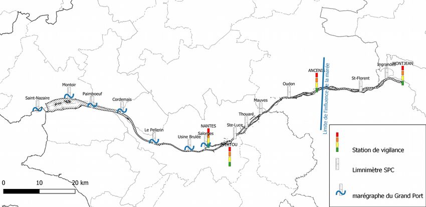
Introduction

- « Vigicrues » : French state device which aim to warn and forecast flood

    → the organization
    → the warning procedure
    → the forecast graphics

- la Loire : an example of forecasting in estuary

    → the estuary description and equipments
    → the model used to make forecast
Vigicrues
            The French warning flood device

                                                               METEOROLOGIST
                                                                     provide
                                                                meteorological data
                                                                (observations and
                                                                    forecasts)

        HYDROMETERS
 collect and analyze hydrological
 data (water level and flow) from
  the 1500 real-time measuring
       stations available on
      www.vigicrues.gouv.fr.
They perform the stream gauging

                           FLOOD FORECASTERS
            aggregate and evaluate these data. They make forecasts
                for the network of rivers supervised by the State.
            They produce and broadcast at least twice a day (at 10am
            and 4pm) and, if necessary, day and night, if the situation
                                    requires it.

                 A LOCAL AND NATIONAL REPORT AND THE
                    ASSOCIATED FLOOD WARNING MAP
FLOOD FORECASTERS

                Vigicrues
aggregate and evaluate these data. They make forecasts
 for the network of watercourses supervised by the State.
They produce and broadcast at least twice a day (at 10am
and 4pm) and, if necessary, day and night, if the situation
                        requires it.

    A LOCAL AND NATIONAL REPORT AND THE
       ASSOCIATED FLOOD WARNING MAP

                   FLOOD WARNING
         On the map, each stream is divided into
                   sections with a color :
               green, yellow, orange or red.
       It indicates the level of warning required to
      cope with the risk of flooding for the next 24
       hours. It is associated with behavioral tips.

        INFORMATION BROADCASTING

                           Mayors
           Following the alert triggered by the
         prefects, they warn the population and
                     mobilize rescue.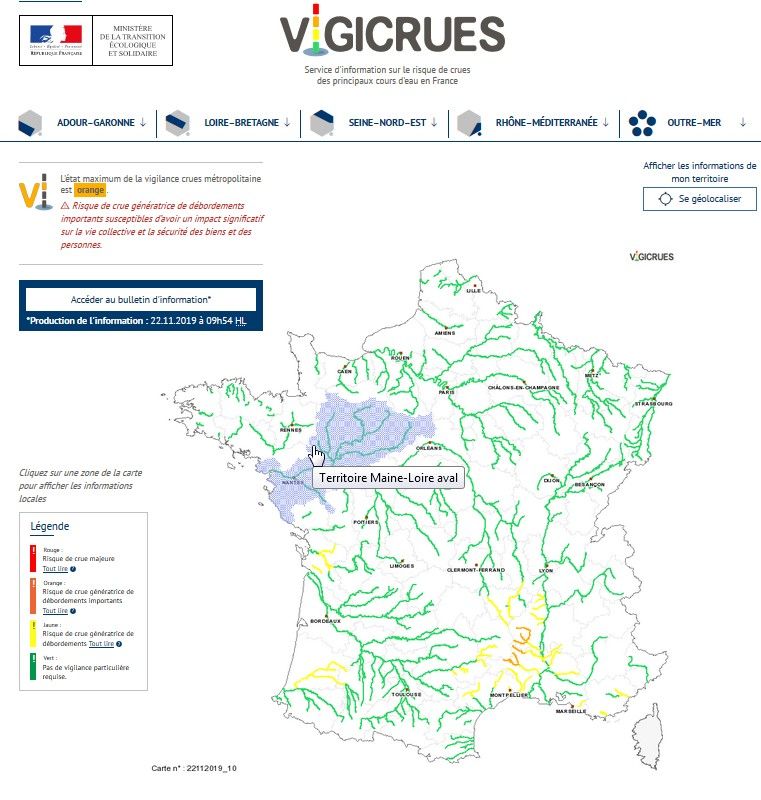
The flood warning procedure
!   Level 4 : RED                                          Rare and catastrophic
                                                           flood.
    Risk of major flood. Direct and widespread threat
    to the safety of people and goods.

!   Level 3: ORANGE                                       Generalized overflows,
                                                          highly disturbed circulation,
    Flood risk generating significant overflows likely to evacuations.
    have a significant impact on the collective life and
    the safety of property and people.

!   Level 2: YELLOW                                        Localized overflows,
                                                           isolated cuts of roads,
    Risk of flooding or rapid rise of waters not causing   isolated houses affected,
    significant damage, but requiring particular           disruption of activities
    warning in the case of seasonal and / or exposed       related to the river.
    activities.

!   Level 1: GREEN                                         Normal situation

    No special warning required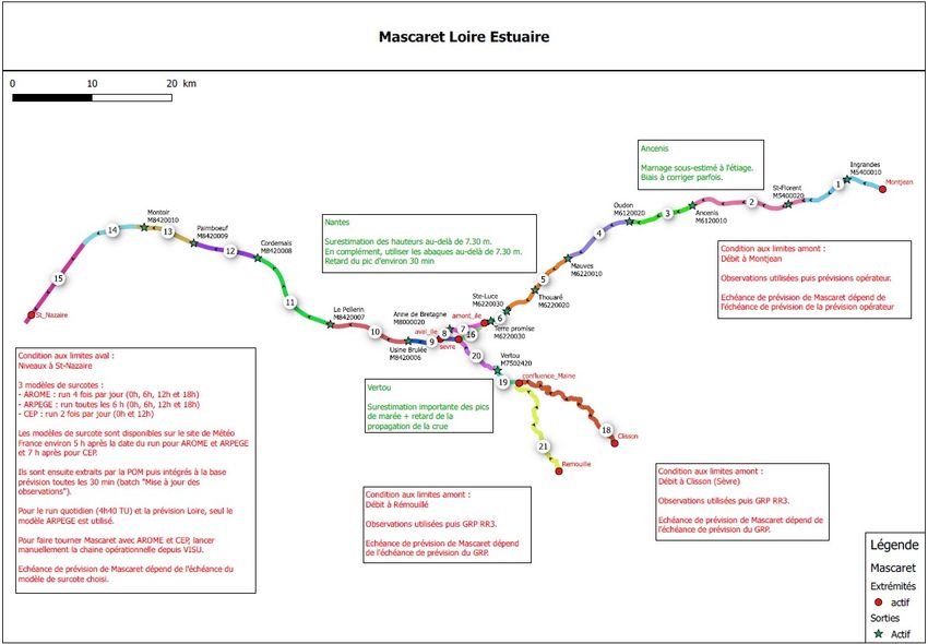
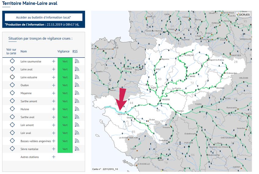
www.vigicrues.gouv.fr

  Vigicrues is divided in
  19 flood forecasting
  departments
Vigicrues
Vigicrues

The forecast are provided with 3 trends : the low, the high and the middle trend
The Loire estuary

                                                Vigicrues

           GPMNSN

Seaport of Nantes - Saint-Nazaire

                                                            Warning station

                                                            Vigicrues level sensor

                                                            GPMNSN level sensor
                         Last warning station
Flood forecast on Loire estuary

Today we make flood forecast 6 day a week all year long :
- Ancenis (low tide forecast)
- Nantes (high tide forecast)

To make forecast, we use a hydraulic model developped by EDF (French
electricity supplier) and CEREMA (French technical institute).

The MASCARET software is a one-dimensional hydraulic modeling code
with free surface, based on shallow water equations.

We still use abacuses made with historical flood.

  « A Finite Volume Solver for 1D Shallow-Water Equations Applied to an Actual River », N.
  Goutal and F. Maurel, Int. J. Numer. Meth. Fluids 2002; 38:1-19

  « MASCARET : a 1-D Open-Source Software for Flow Hydrodynamic and Water Quality in Open Channel Networks », N.
Goutal, J.-M. Lacombe, F. Zaoui and K. El-Kadi-Abderrezzak, River Flow 2012 – Murillo (Ed.), pp. 1169-1174
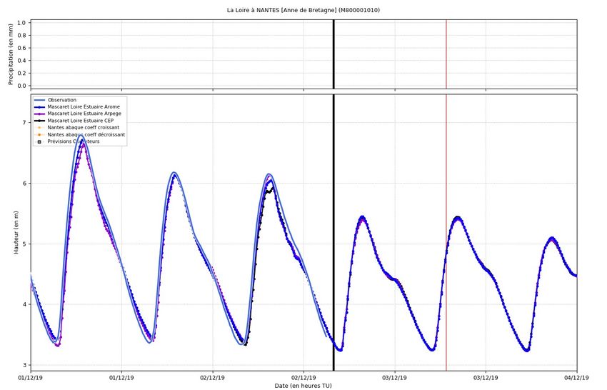
La prévision

         Aujourd’hui prévision 6J/7 toute l’année à :
         - Ancenis (prévision à basse mer si influence de la marée)
         - Nantes (prévision à pleine mer)
                                                                                 Upstream limit condition :
         Utilisation surtout d’un modèle Mascaret (de Montjean à St-Nazaire)    et
                                                                     Montjean observation flow
         utilisation d’abaque (pour des cotes importantes).          +
                                                                                 Flow forecast made by
                                                                                 Vigicrues
         Condition
Downstream              aux
           limit condition :   limites Mascaret :
Saint-Nazaire observation level
+          - débit à Montjean (Loire) : observé puis prévision opérateur
3 models of-levels
              Clisson      (Sèvre Nantaise) : observé puis GRP RR3
                   from Meteo
France (French weather forecast)
and ECMWF  - Rémouillé           (affluent de la Sèvre Nantaise) : observé puis GRP
              (European Centre for                                                    RR3
           - Hauteur
Medium-Range                à St-Nazaire
              Weather Forecasts ):           : observé puis ARPEGE/AROME/CEP
                                                                        Upstream limit condition :
AROME, ARPEGE and CEP                     Upstream limit condition :
                                                                        Clisson observation flow
                                          Remouillé observation flow    +
                                          +                             Hydrologic model
                                          Hydrologic model
Météo France level forecast
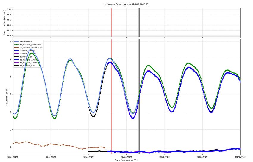
La Loire à Saint-Nazaire
Saint-Nazaire : the downstream limit condition with 3 models from Météo France
(AROME, ARPEGE, CEP)
Ob
ser
ved
le vel
e l
lev (Mo Mo
del del
c ted ed ed
i lev sto
r ed el – rm
P
pre surg
dic e
ted
lev
el)Model result La Loire à Nantes
Vigicrues level forecast
                             La Loire à Nantes
In the Loire estuary section, only one warning station.

If the forecast exceeds the yellow threshold in the next 24 hours
→ we will decide to put the yellow warning for the Loire estuary section.
Prospect A new warning and forecast station on the Loire Estuary section ? Industrial issues are present throughout the Loire from Nantes to Saint- Nazaire. Make forecasts in this zone could help these industries to cope with the risk of flooding and/or polluant spreading in Loire.
You can also read