Village of Larsen, WI - Supplemental Submittal in Support of the Incorporation of the - Wisconsin Department of Administration
←
→
Page content transcription
If your browser does not render page correctly, please read the page content below
RECEIVED
                                           April 2, 2021
                                        Municipal Boundary Review
                                        Wisconsin Dept. of Admin.

Supplemental Submittal in Support of the
                   Incorporation of the

         Village of Larsen, WI
                   Case Number 18-CV-990
                                       Petitioners:
      Arden E Schroeder, Designated Representative
        Mark E Luebke, Designated Representative

                                      Prepared by:
                              The Town of Clayton
                                 with support from
                          William L Forrest, AICP
                         Forrest & Associates, LLC

                                  Submission Date:
                                     April 2, 2021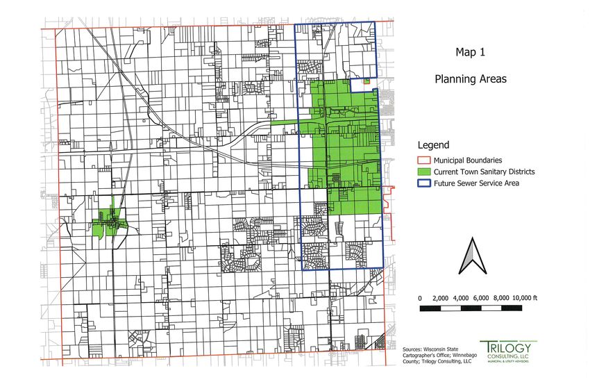
Village of Larsen                                                     ii

Table of Contents[SR1]
Executive Summary ………………………………………………..…………………….….
                                             1
Memorandum of Law ………………………………………………..…………………
                                            2
Affidavit of Trustee Russell Geise ………………………………………………………...
                                                      7
Section 1(b): Territory Beyond the Core …………………………………..………
                                                         11
    Waiver Request ……………………………………………………….…….……12
    Development Opportunities……………..………………………………….……14
    Village Size ……………………………………………………………………..…14
Section 2(a): Tax Revenue …………………………………………………………….…
                                                15
    Financial Response …………………………………..…………………….……16
Conclusion ………………….…………………………………………………………...19

                               Supplemental Incorporation Submittal
Village of Larsen                                                             iii

Maps
 Supplemental Map 10A Depth to Water Table Detail
 Supplemental Map 11A Soil Potential for Homes with Basements Detail

                                       Supplemental Incorporation Submittal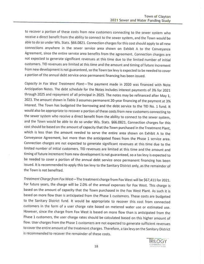
Village of Larsen                                                             iv

Supplemental Exhibits
 Supplemental Exhibit 1 Summary Budgets
 Supplemental Exhibit 2 Special Fund Budgets
 Supplemental Exhibit 3 Sewer and Water Funding Study

                                       Supplemental Incorporation Submittal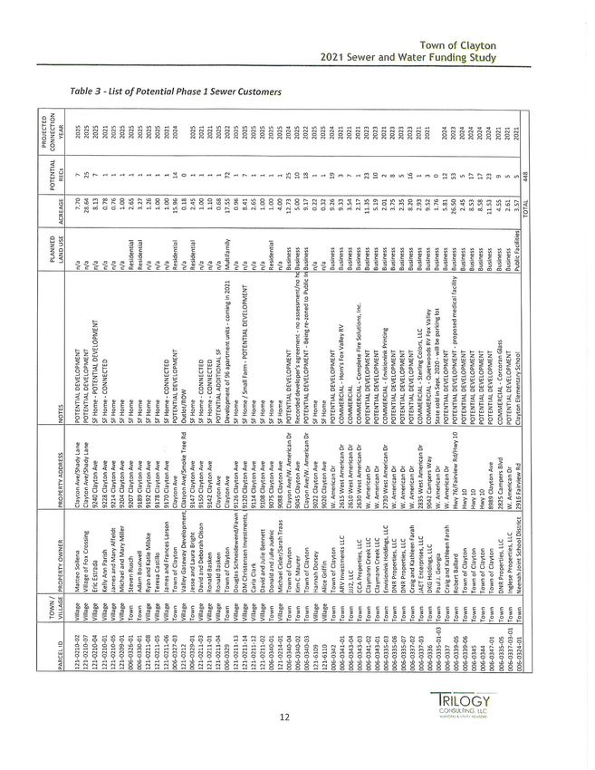
Village of Larsen                                                                           1

Executive Summary
This document is in response to testimony received at the WI DOA Incorporation Review
Board Public Hearing regarding the Incorporation of the Village of Larsen. Included is
supplemental information and analysis prepared by the Petitioners to demonstrate to the
Incorporation Review Board (IRB) that the Village’s petition for incorporation meets all
statutory standards in Section 66.0207, Wis. Stats. to incorporate the urbanizing portion
of the Town of Clayton into a metropolitan village, to be known as the Village of Larsen.
The incorporation of the Village is of vital importance to the management of orderly
western growth of the ever-expanding Fox Valley that is destined to occur in the ensuing
months and years.

                                            Supplemental Incorporation Submittal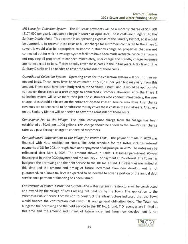
Village of Larsen                                                                                         2

 DALE W. ARENZ - Retired                      730 N. GRAND AVENUE                         PAUL E. ALEXY
 DONALD S. MOLTER, JR. - Retired            WAUKESHA, WISCONSIN 53186               MATTEO REGINATO
 JOHN P. MACY                                 Telephone (262) 548-1340               LUKE A. MARTELL
 H. STANLEY RIFFLE - Court Commissioner         Direct (262) 806-0212            SAMANTHA R. SCHMID
 ERIC J. LARSON                                Facsimile (262) 548-9211       CHRISTOPHER R. SCHULTZ
 REMZY D. BITAR                                Email: sriffle@ammr.net             ANTHONY J. GARCIA
                                                                                     SADIE R. ZURFLUH
                                                                                         -----------
                                                                             STEPHEN J. CENTINARIO, JR.
                                                                                    MICHAEL J. MORSE
                                                                                        JAMES P. WALSH

                                          MEMORANDUM OF LAW

                                              March 30, 2021

FROM:               Stan Riffle, Special Counsel to the Town of Clayton

Re:                 The Incorporation Petition of the Village of Larsen

       The purpose of this memorandum is to address legal arguments presented by Village of
Fox Crossing Attorney Andy Rossmeissl presented at the public hearing on the Petition held March
23, 2021. At that time, Attorney Rossmeissl opined that the holding in Incorporation of Town of
Pewaukee, 186 Wis. 2d 515 (Wis. Ct. App. 1994) is dispositive as to the authority of the
Incorporation Review Board to exercise its judgment for waiving standards of Wis stat.
§66.0207(1)(b) pertaining to a portion of the lands included in the boundaries of the proposed
Village of Larsen. My friend and colleague is wrong.

         Wis stat. §66.0207(1)(b) provides:

      Territory beyond the core. The territory beyond the most densely populated one-half
      square mile specified in s. 66.0205 (1) or the most densely populated square mile
      specified in s. 66.0205 (2) shall have an average of more than 30 housing units per

                                                         Supplemental Incorporation Submittal
Village of Larsen                                                                                                                   3

     quarter section or an assessed value, as defined in s. 66.0217 (1) (a) for real estate tax
     purposes, more than 25 percent of which is attributable to existing or potential
     mercantile, manufacturing or public utility uses. The territory beyond the most densely
     populated square mile as specified in s. 66.0205 (3) or (4) shall have the potential for
     residential or other urban land use development on a substantial scale within the next
     3 years. The board may waive these requirements to the extent that water, terrain
     or geography prevents the development.

As reported by Attorney Rossmeissl, the Court of Appeals addressed the waiver issue in
Incorporation of Town of Pewaukee.1 Mr. Rossmeissl read portions of the opinion, but for ease of
reference, I include all relevant excerpts here:

          Finally, we address the DOD's determination under the potential for development
          factor. Under § 66.016 (1)(b), STATS., the DOD determined that "[t]he territory
          beyond the most densely populated square mile" did not "have the potential for
          residential or other urban land use development on a substantial scale within the
          next 3 years." The DOD found that certain sections of land contained
          undevelopable lands zoned for conservancy, as floodland, and lands zoned
          exclusively agricultural. However, the DOD excluded such areas as conservancies
          or floodland in its analysis of potential "development on a substantial scale." The
          DOD determined that sections 29 through 32 did not have the potential for
          "development on a substantial scale" because of the Town's inability to provide
          sewer service to these sections. The DOD stated: "This area of the town is, by itself,
          too large to ignore."

          The Town's underlying argument under this criteria is based on the same contention
          it made under § 66.016 (2)(d), STATS., that there was no substantial evidence of
          the Town's inability to provide sewer service to this area. However, as we stated
          before, we hold that substantial evidence supports the DOD's finding that the Town
          could not provide sewer service to this area. Therefore, we hold that the DOD's
          ultimate conclusion that this area did not have the potential for development under
          the Town's incorporation was supported by substantial evidence.

          The Town also argues that the DOD should have waived the "potential for
          development" requirement for these lands. The DOD acknowledged that the
          standard in subsec. (1)(b) allows it to waive this requirement "to the extent that
          water, terrain or geography prevents such development." See § 66.016 (1)(b),

1 Please note that I represented the Town (now City) of Pewaukee in this case and statements made relating to the distinctions in
factual circumstances are from personal knowledge.

                                                                 Supplemental Incorporation Submittal
Village of Larsen                                                                            4

   STATS. However, the DOD concluded that the provision does not allow waiver for
   land which is excluded for policy reasons by zoning.

   The Town contends that the § 66.016 (1)(b), STATS., provision allows waiver for
   agricultural zoning because the word "geography" in the provision contemplates
   the "impact of man and his industries" on the physical characteristics of the area.
   The Town argues that agricultural zoning is such an impact on the physical
   characteristics of an area. We disagree.

   Whether the provision allows a waiver for land zoned for agriculture involves the
   interpretation of a statute which presents a question of law. See Murphy v. LIRC,
   183 Wis.2d 205, 211, 515 N.W.2d 487, 490 (Ct. App. 1994). Here, because the
   DOD did not set forth a definition of "geography," we address the issue without the
   benefit of an administrative agency's statutory interpretation. Thus, our review is
   de novo. See Kelley Co. v. Marquardt, 172 Wis.2d 234, 245-46, 493 N.W.2d 68,
   73-74 (1992).

   In interpreting a statute, we first look to the plain meaning of the statute. See Hainz
   v. Shopko Stores, Inc., 121 Wis.2d 168, 172, 359 N.W.2d 397, 400 (Ct. App. 1984).
   In ascertaining the plain meaning of a term, we may consult a dictionary definition.
   See Johnson v. City of Darlington, 160 Wis.2d 418, 427, 466 N.W.2d 233, 236
   (Ct.App. 1991). Although, as the Town argues, "geography" as a science deals with
   the distribution of "man and his industries" in relation to the land, sea and air,
   WEBSTER'S THIRD NEW INT'L DICTIONARY 948 (unabr. 1976), we do not
   discern from the statutory language that the legislature intended to invoke the entire
   science of geography as a reason to waive the requirement of this section. Under
   this construction, the exception would swallow the rule. See Wisconsin Power Light
   Co. v. Public Serv. Comm'n, 181 Wis.2d 385, 395, 511 N.W.2d 291, 295 (1994).
   As the City of Waukesha contends, any township seeking incorporation could
   simply zone certain areas as agricultural to avoid the "potential for development"
   requirement.

   We hold that the plain meaning of "geography" relates to "the natural features of a
   region." See THE NEW MERRIAM-WEBSTER DICTIONARY 315 (1989). If the
   natural features of the region, such as a hill composed of solid rock for example,
   made potential development of that area prohibitive, if not impossible, it would
   make sense to waive the "potential for development" criterion relating to that
   specific area. Agricultural zoning, however, is not a natural feature prohibiting
   development; zoning is a legislative choice limiting development. See Quinn v.
   Town of Dodgeville, 120 Wis.2d 304, 308, 354 N.W.2d 747, 750 (Ct.App. 1984),

                                              Supplemental Incorporation Submittal
Village of Larsen                                                                                          5

       aff'd, 122 Wis.2d 570, 364 N.W.2d 149 (1985). Therefore, we hold that § 66.016
       (1)(b), STATS., does not allow waiver on the basis of agricultural zoning.

       We conclude, when considering the DOD's determination as a whole, that its
       determination was consistent with the legislative objective to avoid the creation of
       governmental units too fragmented to supply necessary services and to perform
       necessary functions in an economically efficient manner. See Salbashian, 128
       Wis.2d at 354, 382 N.W.2d at 59-60. A reasonable reading from the DOD's
       incorporation determination under the three criteria is that the DOD concluded that
       the City of Waukesha and the Village of Pewaukee are better equipped than the
       proposed City of Pewaukee to supply certain services to the area residents. That
       determination is based upon substantial evidence and is not arbitrary or capricious.
       We will not disturb it. Incorporation of Town of Pewaukee, 186 Wis. 2d 515, 529-
       32 (Wis. Ct. App. 1994).

        Incorporation of Town of Pewaukee clearly does not bind the Board here for two reasons.
First, DOD (and the Court) focused on the fact that Pewaukee had not taken measures to allow for
the provision of sewer service to the areas in question. Here, the record is well established that the
Town of Clayton has expended tens of millions of dollars to secure the ability to provide sewer
service to the entirety of the prospective Village, and water to the majority of the territory sought
to be incorporated.

        Second, in Pewaukee, the Town did not argue that the soils within the waiver lands were
of a nature for designation as “prime agricultural lands” – they were not. Prime ag land, as defined
by the U.S. Department of Agriculture, is land that has the best combination of physical and
chemical characteristics for producing food, feed, forage, fiber, and oilseed crops and is available
for these uses. It could be cultivated land, pastureland, forestland, or other land, but it is not urban
or built-up land or water areas. "Prime farmland" is of major importance in meeting the Nation's
short- and long-range needs for food and fiber. Because the supply of high-quality farmland is
limited, the U.S. Department of Agriculture recognizes that responsible levels of government, as
well as individuals, should encourage and facilitate the wise use of our Nation's prime farmland.
https://www.nrcs.usda.gov/wps/portal/nrcs/detailfull/pr/soils/?cid=nrcs141p2_037285.

        Pewaukee argued that the waiver should be applied based upon the Town’s zoning of these
lands as farmland. The Court did not accept this argument, instead stating “agricultural zoning is
not a natural feature…”

                                                    Supplemental Incorporation Submittal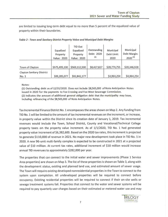
Village of Larsen                                                                                    6

       However, prime soils are indeed a natural feature, and the language of Wis stat.
§66.0207(1)(b) expressly authorizes the waiver by the Board the extent that water, terrain or
geography prevents the development. Prime soils are a feature of terrain, defined as:

(1) : a geographic area
(2) : a piece of land : ground
(3) : the physical features of a tract of land
https://www.merriam-webster.com/dictionary/terrain

        Soils are a components and physical features of a tract of land. Incorporation of Town of
Pewaukee does not address this distinction in any fashion. The Board has the authority to exercise
its judgment in this matter, and should do so.

MUNICIPAL LAW & LITIGATION GROUP, S.C.

H. Stanley Riffle

                                                 Supplemental Incorporation Submittal
Village of Larsen 7
Affidavit of Trustee Russell Geise
Response to IRB Hearing
Russell Geise, Trustee
April 2, 2021
This Affidavit is in response to statements made by City of Neenah Mayor Kaufert
during the Board’s public hearing March 23, 2021.
Supplemental Incorporation SubmittalVillage of Larsen 8
Supplemental Incorporation SubmittalVillage of Larsen 9
Supplemental Incorporation SubmittalVillage of Larsen 10
Supplemental Incorporation SubmittalVillage of Larsen 11
Section 1b: Territory Beyond the Core
§ 66.0207(1)(b) Wis. Stats.
“The territory beyond the most densely populated one-half square mile specified in s.
66.0205 (1) or the most densely populated square mile specified in s. 66.0205 (2) shall
have an average of more than 30 housing units per quarter section or an assessed value,
as defined in s. 66.0217 (1)(a) for real estate tax purposes, more than 25% of which is
attributable to existing or potential mercantile, manufacturing or public utility uses. The
territory beyond the most densely populated square mile as specified in s. 66.0205 (3) or
(4) shall have the potential for residential or other urban land use development on a
substantial scale within the next 3 years. The board may waive these requirements to the
extent that water, terrain or geography prevents the development.”
Supplemental Incorporation SubmittalVillage of Larsen 12
Area Requested for Waiver of Development Requirement from
66.0207(1)(b).
Response to IRB Hearing
William L. Forrest, AICP
March 30, 2021
Waiver Request
There were questions expressed at the Incorporation Review Board hearing regarding
the requested waiver from the Wis. Stat. 66.0207(1)(b). The waiver is requested to be
applied to all of Sections 20 and 21, and the north one-half of section 22. In response
to the question, it was expressed that this area presents moderate to severe constraints
for development due to water table and soil conditions.
With respect to water table, much of this area has a depth to the water table of less than
3.3 feet. Map #10 A – Depth to Water Table is being submitted showing further detail of
this condition for the above specified area.
Regarding limitations for basements, this area has substantial areas that are classified
as having “Somewhat Limited” to “Very Limited” conditions for homes with basements.
To illustrate this constraint, Map #11 A – Soil Potential for Homes with Basements is
provided. The source for these conditions is derived from soil mapping prepared and
distributed by the United States Soil Conservation Service. Due to these limitations, it is
likely much of this area will never be developed, and is perhaps best suited to
environmental preservation in the long term.
Of greater importance is the linkage this area provides between the main portion of the
Village (that being the larger area to the east), and the hamlet of Larsen. As was stated
at the hearing, it is imperative that the Village include the hamlet for several reasons:
1. It is the “namesake” for which the new Village is being named, i. e. Larsen. It
was further noted that there is no other Larsen within the State of Wisconsin, and
therefore, any possible confusion is avoided.
2. Existing municipal operations are located in the hamlet, avoiding duplication of
facilities in the future.
3. The Larsen Post Office is located within the hamlet, and has its ZIP Code of
54947.
Supplemental Incorporation SubmittalVillage of Larsen 13
4. There is a small concentration of local businesses in the hamlet, the main one
being the Larsen Cenex Cooperative.
5. The hamlet is served by the Larsen-Winchester Sanitary District. The District is
under orders to abandon the treatment facility in the future, and the extension of
new lines to connect the existing service area will extend east along CTH “II” and
Sections 20, 21, and 22.
In addition, there are other geographical features that limit development within the
proposed Village that were not identified and/or categorized as subject to the requested
development waiver, since it was presumed these areas were “not available for
development.”
In Table 14 – Airport Zoning District Acreages, there are 1,631.84 total acres impacted
by the Airport Overlay Districts. While some development is permitted within the zone, it
is limited, and should be concluded that it is generally not available for development.
Another primary category which caused considerable discussion was the inclusion of
“working lands.” These are generally characterized as highly productive prime farmland.
In retrospect, these lands should not have been included within the proposed
boundaries. This is similar to lands identified in the proposed Village of Greenville,
which then led to the request the boundaries be redefined and the petition be
resubmitted to eliminate the defined farmland, or “working lands.”
In developing the proposed boundary, the objective was to include as much of the
existing development as possible. Given new development to the east, such as the new
high school discussed below, the Petitioners felt that development of the vacant
farmland on a substantial scale is quite likely.
Should the Incorporation Review Board and staff of the Department of Administration
determine that the Village of Larsen is viable with modifications to the proposed
territory, the petitioners and Town of Clayton officials are agreeable to resubmitting a
modified Village Boundary to comply with Wis. Stats. 66.0207(1)(b).
Supplemental Incorporation SubmittalVillage of Larsen 14
Development Opportunities
Table 17 – Proposed Development Projects prompted discussion on the timing of
development within the proposed Village. Intervenors contend that several projects
under consideration were outside the 3-year time frame for meeting the standard.
Petitioners acknowledge that while the timeframe is somewhat vague, developers and
municipalities are aware that project timelines and goals are fluid, especially within the
time frame of concept to implementation. As expressed at the hearing, the petitioner’s
experts remain confident development will continue, and, in fact, is likely to accelerate.
The impetus for the development is the construction of a new High School on lands
adjacent to the proposed Village. The school is projected for completion in 2023. It is
noted that the High School development occurred after the petitioners filed the
Submittal. The school will have a significant impact on density and hasten the speed of
growth, especially residential.
Of further note, sewer and water has been in the planning stages for many years, and
with considerable dollars invested to make it happen. “Putting pipes in the ground” will
have a positive impact on physical development within the Village.
Village Size
The proposed Village is 18.5 square miles. It was implied that the Village was extremely
large and out of character with other incorporations. Below is a comparison of past
incorporations with Larsen:
• Weston 13.4 square miles
• Kronenwetter 11.04 square miles
• Lake Hallie 14.22 square miles
• Richfield 36.0 square miles
• Bristol 10.0 square miles
• Summit 25.0 square miles
• Bloomfield 12.0 square miles
• Somers 12.0 square miles
• Menasha 9.0 square miles
• Greenville 16.89 square miles
Supplemental Incorporation SubmittalVillage of Larsen 15
Section 2a: Tax Revenue
§ 66.0207 (2)(a), Wis. Stats. The present and potential sources of tax revenue appear
sufficient to defray the anticipated cost of governmental services at a local tax rate which
compares favorably with the tax rate in a similar area for the same level of services.
Supplemental Incorporation SubmittalVillage of Larsen 16
Response to IRB Hearing
Tori Straw, Administrator
March 30, 2021
Financial Response
Some testimony at the Incorporation Review Board public hearing raised questions
regarding the financial data presented for the Village of Larsen and the Remnant Town.
As a result, we have further updated our general and debt service fund budgets to
better reflect an assessed value split for the proposed Village and Remnant Town.
Attached as Supplemental Exhibit 1. The value split is based on our assessor’s review
of all parcels which assigns 87.91 percent to the Village and 12.09 percent to the
Remnant Town. Most revenue and expenses followed this proportional split unless
there was supporting data which justified a different division. Specifically, transportation
aid revenue, licenses and permit revenue, public safety expenses, and public works
expenses were some categories which did not follow the proportional split.
The updated budget data continues to confirm the Remnant Town will function with a
general property tax levy which is similar to other Towns in the area as supported in
Table 22 – Comparable Towns with Population, Taxes, and Equalized Value. These
operations will be without any significant changes in services.
Table 22 - Comparable Towns with Population, Taxes, and Equalized Value
2020 Estimated General Property
County Town Population Taxes Equalized Value
Winnebago Nepeuskun 743 $213,406 $71,367,100
Waupaca Union 815 $249,100 $63,524,500
Shawano Pella 886 $197,061 $82,258,300
Outagamie Maine 880 $114,808 $77,351,500
Marathon Plover 698 $208,313 $52,632,100
Green Cadiz 797 $292,930 $71,272,300
Fond du Lac Oakfield 718 $209,916 $67,283,600
Calumet Charlestown 782 $183,019 $75,935,400
Calumet Rantoul 816 $235,845 $80,568,100
Clayton
Winnebago (Remnant Town) 850 $111,184 $69,577,358
Source: Forrest & Associates, LLC; Wisconsin Department of Revenue; Revised 03/2021
Supplemental Incorporation SubmittalVillage of Larsen 17
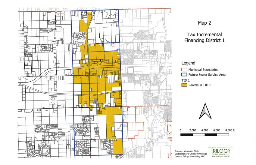
Also attached as Supplemental Exhibit 2 are summary budgets for the Solid Waste
Recycling Fund, Stormwater Management Utility Fund, TID Fund, and Sanitary District
#1 Fund.
Some questions were raised about the debt of the Town. Under the Fox Crossing
Agreements, the Town agreed to pay Fox Crossing a total of $11.5M in two
installments. The Town also entered into an agreement with the Fox West Sewerage
Commission to permit the conveyance of wastewater to the Fox West Regional
Wastewater Treatment Plant. Under the agreement, the Town paid a one-time buy-in
charge of $1.2M. The Town financed these payments and capitalized interest with a 5-
year Note Anticipation Note (NAN). The Town plans to refund/refinance the notes and
as the TID revenue increment grows, it will help to fund a portion of the debt payments.
The Town has also entered into an agreement with IPR Clayton LLC (IPR) to construct
the first phase of the sanitary sewer collection system in the Town. IPR will then lease
the system to the Sanitary District #1. The lease payments total $174,000 per year
which is reflected in the Sanitary Fund budget. The Town has the option to buy the
system after the third anniversary of the first year of the lease for the remaining amount
of the construction loan.
The Village of Fox Crossing agreed to provide water service to the area of the Town
within the Sanitary District. The Town is required to design and construct the water
distribution system within the Town, and then dedicate the improvements to the Village.
The Village Water Utility will own, operate, and maintain the water system within the
Town, and will directly bill customers in the Town as the utility’s retail customers.
Customers in the Town will pay the same rates for water service as customers in the
Village. The agreement further specifies that any future extensions of the water system
within the Town beyond the initial improvements will also be constructed and paid for by
the Town. The agreement also allows the Town the option to purchase the Town water
system from the Village for $1.00 in the future and will then become a wholesale
municipal customer when authorized to do so by the Wisconsin Public Service
Commission (PSC). The Authorization from the PSC to extend the Village water system
into the Town was granted on February 11, 2021. Total cost of the water distribution
system is currently estimated at $2.6M. This cost is substantially less than the originally
budgeted amount of $3.8M. The current estimated $2.6M along with the 2nd installment
of $5M to Fox Crossing will be financed with a Note Anticipation Note (NAN) and is
reflected in the TID Budget.
The Town anticipates the water distribution system to be fully functional in the fall of
2021. Sewer and water fees will be charged by the respective operating entity when
both systems are operational. The Town has completed a Sewer and Water Funding
Supplemental Incorporation SubmittalVillage of Larsen 18
Study in February 2021 to help identify funding strategies for recovery of costs and set
appropriate rates. The study is attached as Supplemental Exhibit 3. Strategies for
recovery of costs include sanitary district general property tax levies, user charges,
sewer availability charges, connection fees – Fox West, and connection fees – sewer
imbursement. These strategies along with the TID increment, the Village of Larsen
general fund, and anticipated land sales will fund the future debt payments.
The petitioners maintain the Village of Larsen as well as the Remnant Town will not only
be financially viable, but will continue to exceed the expectations of their respective
residents. Additionally, the current and anticipated growth and development in the
Village of Larsen will further shore up the financial stability of the Village.
Supplemental Incorporation SubmittalVillage of Larsen 19
Conclusion
The Incorporation Review Board has clearly recognized that this immediate area will be
a rapidly expanding urban area. This development is inevitable. Management of this
growth will best be managed by an incorporated municipality. The proposed Village will
be able to strengthen its land use authority by utilizing all the tools available to that of an
incorporated village. The financial capabilities of a Village will minimize the burden on
taxpayers and maximize the available infrastructure to support this development. An
incorporated village affords the surrounding municipalities the ability to plan efficiently for
the metropolitan area and create strong partnerships that will contribute to developing
solutions to regional problems.
Supplemental Incorporation SubmittalVillage of Larsen
Winnebago County, Wisconsin
Friendship Tra il Incorporation Submittal
Map #10 A
ORCHID LN Depth to Water Table
a il
ta te Tr
16 15 Legend
UMLAND RD WA SH
S 17 0 feet
0.50 feet
W I OU
CENTER RD
1.0 feet
HICKORY AVE
2.5 feet
3.3 feet
Greater than 5.8 feet
COUNTY RD II Depth to Water Table at
WHIS PERING MEAD OWS DR
ROLLING MEAD OWS
selected sites and on evidence
of a saturated zone in the soil.
22
PIONEER RD
21
DEKALB LN
20
R FONDOTTO DR
COUNTY RD T EST D
H ARV
CHA LLENGER DR
EN
GOL D
COUNTY RD T
GALAXY DR
LARSEN RD
PRAIRIEWOOD TR
µ
Y
W
PK
G
ROYAL SIERRA TR
N
N
W
SI
O
CR
OAKWOOD AVE
OS
D
AL
CR
ER Approximate Scale
EM
S
W O
27
0 500 1,000 2,000 3,000 4,000
AD
28
Feet
ME
29
HILLCR EST DR
NDA
The base map was created by the Winnebago County
GR
Geographic Information Systems. Any other use/application
by others, is the responsibility of the user. Winnebago County
disclaims all liability regarding fitness of the information.
CENT ER RD
COUNTY RD T
pnac267559lu_ad2015.dwg_Adopted 8/17/2016
pnac267559lu_ad2015.dwg_Revised_10/09/2017
printed_arcgis10018045gis2017.mxd_6/17/2020Village of Larsen
Winnebago County, Wisconsin
Friendship Tra il
Incorporation Submittal
Map #11 A
ORCHID LN Soil Potential for Homes
a il
with Basements
ta te Tr
16 15
UMLAND RD WA SH
S 17 Soils Ratings
W I OU
Not limited
CENTER RD
HICKORY AVE
Somewhat limited
Very limited
COUNTY RD II
Rating class terms indicate the extent to
WHIS PERING MEAD OWS DR
ROLLING MEAD OWS
which the soils are limited by all of the
soil features that affect the specified use.
22
PIONEER RD
21
DEKALB LN
20
R FONDOTTO DR
COUNTY RD T EST D
H ARV
CHA LLENGER DR
EN
GOL D
COUNTY RD T
GALAXY DR
LARSEN RD
PRAIRIEWOOD TR
µ
Y
W
PK
G
ROYAL SIERRA TR
N
N
W
SI
O
CR
OAKWOOD AVE
OS
D
AL
CR
ER Approximate Scale
EM
S
W O
27
0 500 1,000 2,000 3,000 4,000
AD
28
Feet
ME
29
HILLCR EST DR
NDA
The base map was created by the Winnebago County
GR
Geographic Information Systems. Any other use/application
by others, is the responsibility of the user. Winnebago County
disclaims all liability regarding fitness of the information.
CENT ER RD
COUNTY RD T
pnac267559lu_ad2015.dwg_Adopted 8/17/2016
pnac267559lu_ad2015.dwg_Revised_10/09/2017
printed_arcgis10018045gis2017.mxd_6/17/2020SUMMARY BUDGETS 1- and 5-Year Projections
2021 TOWN 2021 REMNANT 2026 REMNANT
2021 VILLAGE 2026 VILLAGE
FUND, SOURCE & FUNCTION DESCRIPTIONS Existing Approved TOWN TOWN
Proposed Budget Projected Budget
Budget Proposed Budget Proposed Budget
GENERAL FUND REVENUE
TAX LEVY $ 919,639 $ 808,455 $ 111,184 $ 892,579 $ 122,777
TAX LEVY - MANUFACTURED HOUSING and MFL $ 14,800 $ 14,000 $ 800 $ 15,523 $ 817
LOAN PROCEEDS $ 1,462,050 $ 1,462,050 $ - $ - $ -
INTERGOVERNMENTAL REVENUES $ 337,535 $ 370,199 $ 68,169 $ 398,234 $ 75,264
LICENSE AND PERMIT REVENUES $ 95,950 $ 85,986 $ 9,964 $ 94,935 $ 11,001
PUBLIC CHARGES REVENUE $ 11,700 $ 11,011 $ 689 $ 12,157 $ 761
INTEREST INCOME $ 10,000 $ 8,800 $ 1,200 $ 10,541 $ 500
MISCELLANEOUS REVENUE/CARRYOVER BAL $ 324,173 $ 301,536 $ 22,637 $ 210,792 $ 25,864
TOTAL REVENUES $ 3,175,847 $ 3,062,037 $ 214,643 $ 1,634,762 $ 236,983
GENERAL FUND EXPENDITURES
GENERAL GOVERNMENT $ 584,182 $ 511,875 $ 83,332 $ 552,979 $ 92,005
PUBLIC SAFETY EXPENSES $ 414,113 $ 386,751 $ 30,989 $ 423,000 $ 34,214
PUBLIC WORKS EXPENSES $ 642,683 $ 631,656 $ 97,206 $ 602,251 $ 107,323
HEALTH & HUMAN SERVICES EXPENSE $ 7,769 $ 7,676 $ 93 $ 8,475 $ 103
CULTURE, RECREATION AND EDUCATION EXPENSES $ 21,550 $ 21,550 $ - $ 23,793 $ -
CONSERVATION AND DEVELOPMENT EXPENSES $ 25,000 $ 21,979 $ 3,023 $ 24,264 $ 3,338
CAPITAL IMPROVEMENT EXPENSES: $ 1,480,550 $ 1,480,550 $ -
TOTAL EXPENDITURES $ 3,175,847 $ 3,062,037 $ 214,643 $ 1,634,762 $ 236,983
GENERAL FUND TAX LEVY $ 919,639 $ 808,455 $ 111,184 $ 892,579 $ 122,777
DEBT SERVICE FUND REVENUE
DEBT SERVICE LEVY $ 826,973 $ 726,992 $ 99,981 $ 1,323,250 $ 90,543
SPECIAL ASSESSMENTS $ 24,887 $ 21,878 $ 3,009 $ 24,887 $ -
SPECIAL ASSESSMENTS INTEREST $ 4,500 $ 3,956 $ 544 $ 1,500 $ -
DEBT RESERVE FUND (ESTAB. FOR $8.565 (NAN) 5/4/20 $ 256,950 $ 225,885 $ 31,065 $ - $ -
TOTAL DEBT SERVICE REVENUES $ 1,113,310 $ 978,711 $ 134,599 $ 1,349,637 $ 90,543
DEBT SERVICE FUND EXPENDITURES
TRANSFER TO TID FUND $ 664,888
PRINCIPAL PAYMENTS $ 594,868 $ 522,948 $ 71,920 $ 623,810 $ 85,791
INTEREST $ 518,442 $ 455,762 $ 62,680 $ 34,552 $ 4,752
$ - $ -
TOTAL DEBT SERVICE EXPENDITURES $ 1,113,310 $ 978,711 $ 134,599 $ 1,323,250 $ 90,543
TOTAL PROPERTY TAX LEVY $ 1,746,612 $ 1,535,447 $ 211,165 $ 2,215,829 $ 213,319
MILL RATE (In Dollars Per Thousand) Equalized Value 3.07 3.07 3.03 4.01 2.78
EQUALIZED VALUE (TID out for Village only) $ 569,112,500 $ 500,306,799 $ 69,577,358 $ 552,379,132 $ 76,819,025SUMMARY BUDGETS 1- and 5-Year Projections
2021 TOWN 2021 REMNANT 2026 REMNANT
2021 VILLAGE 2026 VILLAGE
FUND, SOURCE & FUNCTION DESCRIPTIONS Existing Approved TOWN TOWN
Proposed Budget Projected Budget
Budget Proposed Budget Proposed Budget
SOLID WASTE RECYCLING SPECIAL REV FUND
SPECIAL ASSESSMENTS $ 368,200 $ 323,685 $ 44,515 $ 357,374 $ 49,149
RECYCLING GRANTS/REBATES/OTHER $ 10,850 $ 9,538 $ 1,312 $ 10,531 $ 1,448
INTERGOVERMENT REVNEUE $ 45,827 $ 50,597
TOTAL SOLID WASTE RECYCLING REVENUES $ 379,050 $ 379,050 $ 45,827 $ 418,502 $ 50,597
SOLID WASTE RECYCLING EXPENSES
CONTRACTED GARBAGE SERVICES $ 293,738 $ 293,738 $ 324,310
PAYROLL EXPS $ 25,779 $ 25,779 $ 28,462
CAPITAL EQUIP/DEVELOPMENT/RESERVE $ 49,183 $ 49,183 $ 54,302
ADMIN/SUPPLIES/OTHER $ 10,350 $ 10,350 $ 11,427
INTERGOVERMENT EXPENDITURE $ 45,827 $ 50,597
TOTAL SOLID WASTE RECYCLING EXPENDITURES $ 379,050 $ 379,050 $ 45,827 $ 418,502 $ 50,597
STORMWATER MANAGEMENT UTILITY
SPECIAL ASSESSMENTS $ 309,166 $ 309,166 $ 341,344 $ -
CULVERT AND ACCESS PERMITS $ 3,500 $ 3,500 $ 3,864 $ -
SALE OF SALVAGE MATERIAL $ 250 $ 250 $ 276
TOTAL STORMWATER MANAGEMENT REVENUES $ 312,916 $ 312,916 $ - $ 345,485 $ -
STORMWATER MANAGEMENT UTILITY EXPENSES
UTILITY PROJECTS $ 113,634 $ 113,634 $ 125,461 $ -
PAYROLL EXPS $ 161,067 $ 161,067 $ 177,831
CAPITAL EQUIP $ 20,815 $ 20,815 $ 22,981
MAINTENANCE/FUEL $ 9,000 $ 9,000 $ 9,937
ADMIN/SUPPLIES/OTHER $ 8,400 $ 8,400 $ 9,274
TOTAL STORMWATER EXPENSES $ 312,916 $ 312,916 $ - $ 345,485 $ -
TID FUND
TAX LEVY INCREMENT $ 110,000 $ 110,000 $ 282,344 $ -
PROCEEDS FROM BORROWING (FOX CROSSING PAYMENTS - GO $ 5,210,000 $ 5,210,000 $ 8,565,000 $ -
NAN)
PROCEEDS FROM BORROWING (NAN - water sytem construction $ 3,845,000 $ 3,845,000
TRANSFER FROM GENERAL FUND $ 664,888
TRANSFER FROM SANITARY DISTRICT $ 135,647
TOTAL TID REVENUES $ 9,165,000 $ 9,165,000 $ - $ 9,647,879 $ -
TID FUND
DEBT PAYMENT/INTEREST/FINANCING $ 210,000 $ 210,000 $ 9,612,378
CAPITAL IMPROVEMENTS $ 8,769,500 $ 8,769,500
DEVELOPER PROJECTS INCENTIVES $ 150,000 $ 150,000 $ -
ADMIN/PLANNING/SUPPLIES/OTHER $ 35,500 $ 35,500 $ 35,500
TOTAL TID EXPENSES $ 9,165,000 $ 9,165,000 $ - $ 9,647,878 $ -
SANITARY DISTRICT #1
TAX LEVY $ 100,000 $ 100,000 $ 8,548
USER CHARGES $ 254,111
SEWER AVAILABILITY CHARGE/SPECIAL ASSESSMENTS $ 45,000 $ 45,000 $ 17,539
HOOK UP FEES/CONNECTION FEES - FOX WEST $ 45,000 $ 45,000 $ 133,704
HOOK UP FEES/ CONNENCTION FEES - SEWER IMBURSEMENT $ 30,000 $ 30,000 $ 1,943
TOTAL SANITARY DISTRICT REVENUES $ 220,000 $ 220,000 $ - $ 415,845 $ -
SANITARY DISTRICT #1 EXPENSES
LEASE PAYMENT $ 145,000 $ 145,000 $ 174,000 $ -
FOX WEST TREATMENT PLANT ANNUAL COSTS $ 67,411 $ 67,411 $ 72,968
ADMIN/SUPPLIES/OTHER $ 7,580 $ 7,580 $ 33,231
TRANSFER TO TID $ 135,647
TOTAL SANITARY DISTRICT EXPENSES $ 219,991 $ 219,991 $ - $ 280,199 $ -You can also read