Virtual navigation tested on a mobile app (Sea Hero Quest) is predictive of real-world navigation performance: preliminary data - bioRxiv
←
→
Page content transcription
If your browser does not render page correctly, please read the page content below
bioRxiv preprint first posted online Apr. 22, 2018; doi: http://dx.doi.org/10.1101/305433. The copyright holder for this preprint
(which was not peer-reviewed) is the author/funder, who has granted bioRxiv a license to display the preprint in perpetuity.
                                  It is made available under a CC-BY 4.0 International license.

          Virtual navigation tested on a mobile app (Sea Hero
          Quest) is predictive of real-world navigation performance:
          preliminary data
          Coutrot, A.1,2 , Schmidt, S.1 , Pittman, J.1 , Hong, L.1 , Wiener, J. M.3 , Hölscher, C.4 , Dalton,
          R.C.5 , Hornberger, M.6 , Spiers, H. J.1

          1 Institute of Behavioural Neuroscience, Department of Experimental Psychology, Division
          of Psychology and Language Sciences, University College London, London, United Kingdom.
          2 Laboratoire des Sciences du Numérique de Nantes - CNRS - Université de Nantes, France.
          3 Department of Psychology, Ageing and Dementia Research Centre, Bournemouth University,
          Poole, United Kingdom.
          4 ETH Zürich, Swiss Federal Institute of Technology, Zürich, Switzerland.
          5 Department of Architecture and Built Environment, Northumbria University, Newcastle upon
          Tyne, United Kingdom.
          6 Norwich Medical School, University of East Anglia, Norwich, United Kingdom.

              Abstract
          Virtual reality environments presented on smart-phone and tablet devices have po-
          tential to aid the early diagnosis of conditions such as Alzheimer’s dementia by
          quantifying impairments in navigation performance. However, it is unclear whether
          performance on mobile devices can predict navigation errors in the real-world. In
          a preliminary study we tested 30 participants (15 female, 18-30 years old) on their
          wayfinding ability in our mobile app ‘Sea Hero Quest’ and on novel real-world
          wayfinding task in London (UK). We find a significant correlation between vir-
          tual and real-world navigation performance and a male advantage on both tasks,
          although smaller in the real-world environment. These results are consistent with
          prior studies which have reported navigation in the virtual environments are predic-
          tive of real-world navigation performance and a consistent male advantage. Future
          research will need to test a larger sample size and older participants.

          Keywords: spatial cognition, virtual environment, real world environment, gender differences,
          dementia

          1      Introduction
          Virtual reality (VR) provides a powerful mean to study how humans navigate, because the
          properties of virtual environment can be completely controlled and repeated across participants.
          Testing neuropsychological patients with VR and recording brain activity during VR have allowed
          numerous important insights to be gained in understanding how brain regions support navigation
          [6]. VR also provides the potential to act as an early stage diagnostic tool for Alzheimer’s dementia
          (AD), because spatial disorientation is one of the earliest symptoms [10, 16, 18, 22]. Currently
          there is no standardized test for navigation deficits with AD patients. Until recently most VR
          used in research was presented on a desk-top display and movement controlled via a joystick or

                                                                       1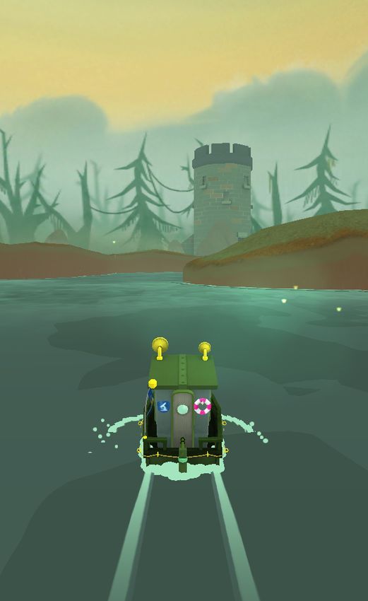
bioRxiv preprint first posted online Apr. 22, 2018; doi: http://dx.doi.org/10.1101/305433. The copyright holder for this preprint
(which was not peer-reviewed) is the author/funder, who has granted bioRxiv a license to display the preprint in perpetuity.
It is made available under a CC-BY 4.0 International license.
keyboard. Such an interface presents difficulties for people who are in the age range where AD may
likely onset (50-70 years old) [8]. However, with the advent of tablet and smart-phone touch screen
mobile devices, old participants have found engaging in VR tasks much easier [19]. We recently
developed a VR navigation task for mobile and tablet devices – Sea Hero Quest [4]– with aim that
this may provide an early diagnostic for AD. For this test to be useful it is important that it has
real-world validity, with errors on the VR task predicting errors in real-world navigation experience.
Past research comparing navigation in real and VR environments has generally found a good
concordance in performance across both tests [1–3, 5, 11, 14, 15, 17, 20, 24]. They have also
found a male advantage for navigation in VR tasks [4, 7, 9, 13] and in real-world tasks [12, 21].
However, prior studies comparing VR and real-world performance have used desk-top VR or
immersive VR to simulate environments. Thus it remains unknown whether virtual navigation
performance, as measured on mobile or tablet device, is also correlated with real-world navigation
behavior. Moreover, when assessing ‘real world navigation behavior’, most prior studies actually
used paper and pencil tests such as line orientation, road map, or delayed recall. A few authors
designed actual navigation tasks but often in a limited spatial range, like the lobby of a hospital
[5]. In this study we designed an ecological navigation task in a large environment covering a
whole neighborhood of London.
2 Methods
The experiment was split into 2 main parts, see Figure 1. First, participants were tested on
specific wayfinding levels from Sea Hero Quest [4] on a tablet. Second, they were tested on a real
world wayfinding task in London. The whole experiment lasted around three hours.
2.1 Participants
We tested 30 participants (15 males), aged 18-30 y.o. (M= 21.96, s.d.= 2.55). We discarded data
from two participants (one male and one female) due to recording problems. Participants had
normal or corrected to normal vision and gave their written consent to participate. The study
was approved by UCL ethics committee. Participants received 3 class credits or £20 for their
participation.
2.2 Virtual task
We devised a mobile video game designed to measure human spatial navigation ability through
gameplay - Sea Hero Quest (SHQ)1 . This video game involves navigating a boat in a virtual
environment (lake or river networks) and has been extensively described in [4]. In brief, the main
levels of the game require participants to view a map displaying current position and future goal
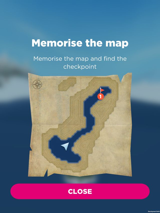
locations to find (Figure 2). Participants could study the map without time restrictions and had
to navigate to the goal locations in the order indicated, e.g. goal 1 must be found first, then goal
2, etc. Goals were buoys with flags marking the goal number. The task is complete when all
goals have been located. If the participant takes more than a set time, an arrow indicates the
direction along the Euclidean line to the goal to aid navigation. On basis of the data from the
online version, we selected a subset of 6 of the total 75 levels in the game that varied in difficulty:
instruction level 1, and wayfinding tasks levels 6, 8, 11, 16, 43 (see Figure 2).
1 www.seaheroquest.com
2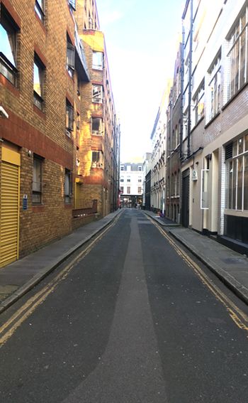
bioRxiv preprint first posted online Apr. 22, 2018; doi: http://dx.doi.org/10.1101/305433. The copyright holder for this preprint
(which was not peer-reviewed) is the author/funder, who has granted bioRxiv a license to display the preprint in perpetuity.
                                  It is made available under a CC-BY 4.0 International license.

          Figure 1. First person view of the virtual (left) and real world (right)
          environments.

          2.3      Real world task
          Akin to the virtual task, our real-world navigational task consisted of 6 wayfinding trials which
          varied in difficulty in terms of the number of streets to be navigated, the number of goals and
          the relative location of the goals to each other (Figure 3). Each trial was located in a different
          street network in the Covent Garden London neighborhood. We chose less busy streets to avoid
          traffic and made sure the participants were not familiar with them. Before each trial, participants
          were shown a map that only indicated the facing direction, the network of the local streets and
          the location and the order of the goals (Figure 3). The goals were doors and gates with distinct
          features (e.g. specific colour, size, or material). Participants had up to 1 min to memorize the
          map (maximum length for Sea Hero Quest) before walking to located the goals. During navigation
          they were provided colour photographs of the goal location doors. Based on pilot testing we set
          specific time limits for each route. Route one: 6 minutes, route two: 6 minutes, route three: 6:30
          minutes, route four: 6:30 minutes, route five: 12 minutes, route six: 14 minutes. We chose these
          time limits to allow for a few mistakes at a reasonable walking pace. Pilot testing indicated that
          if participants required any longer than that these times they were likely guessing and had failed
          to remember the goal locations or street layout. If participants reached the limits of the defined
          region set by the experiment they were told by the experiment they had reached the edge of the
          search area and should turn back.

          2.4      Navigation performance measures
          Virtual task - Performance was quantified with the distance travelled in each level (in pixels).
          We averaged the distance travelled over levels 6 to 16. We did not include level 1 because it
          did not require any spatial ability (the goal was visible from the starting point) and was only
          designed to assess participants’ ability to learn to control the boat. We did not include level 43
          because it was too difficult with only 40% of participants finishing it (see also Figure 5). The
          coordinates of participants’ trajectories were sampled at Fs = 2 Hz.
          Real World task - Because we were not able to reliably measure the metric distance walked we

                                                                       3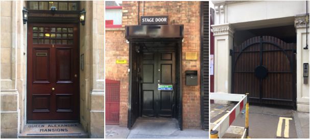
bioRxiv preprint first posted online Apr. 22, 2018; doi: http://dx.doi.org/10.1101/305433. The copyright holder for this preprint
(which was not peer-reviewed) is the author/funder, who has granted bioRxiv a license to display the preprint in perpetuity.
                                  It is made available under a CC-BY 4.0 International license.

          Figure 2. Virtual task Maps of wayfinding levels 1, 6, 8, 11, 16 and 43. Map of level 8 was
          partly blurred as part of our organized structure of testing various properties of the maps and
          environments in Sea Hero Quest (see [4]). Starting position and facing direction are indicated by
          a pale blue arrow, ordered checkpoints by red flags. Participants must memorize the map, and
          then navigate towards the checkpoints in the right order as quick as possible.

                                                                       4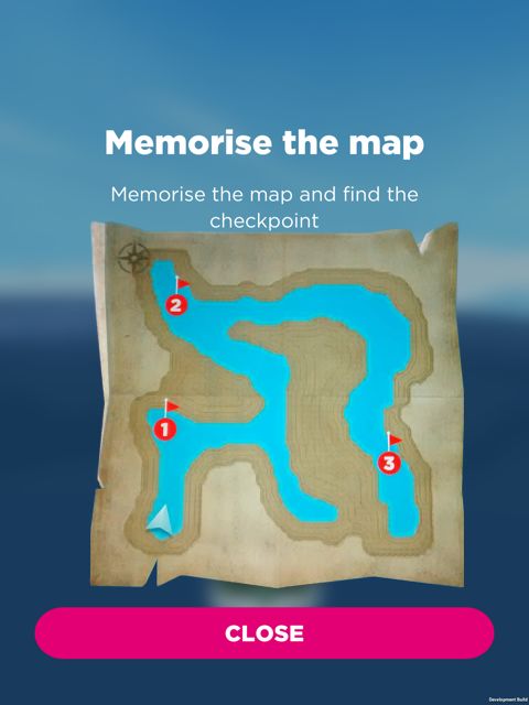
bioRxiv preprint first posted online Apr. 22, 2018; doi: http://dx.doi.org/10.1101/305433. The copyright holder for this preprint
(which was not peer-reviewed) is the author/funder, who has granted bioRxiv a license to display the preprint in perpetuity.
                                  It is made available under a CC-BY 4.0 International license.

             Simple Route

                                                                                3
                                    2

                                                                                                                                       2

                                    3
                                                                                            2

                                                                                                             3

                                         1

                                                                                                START
                                                                                                                        1

                                                START
                                                                                    1
                                                                                                                               START

                                                            Route 4 :

                                                                                                             Route 5

                                                                                                        !"
                                                                                                                                               4

                                2                                                       2

                                                                                                                 3

                                                        1                                                                                  2

                                        START

                            3

                                                                                                                                1

                                                                                        1
                                                                                                                       START
                                                                        Start

          Figure 3. Real wayfinding task Maps of wayfinding routes. Starting position and facing
          direction are indicated by a yellow arrow, ordered checkpoints by red dots. Participants must
          memorize the map, and then walk towards the checkpoints in the right order as quick as possible.
          Checkpoints are materialized by remarkable doors (bottom row).

                                                                                        5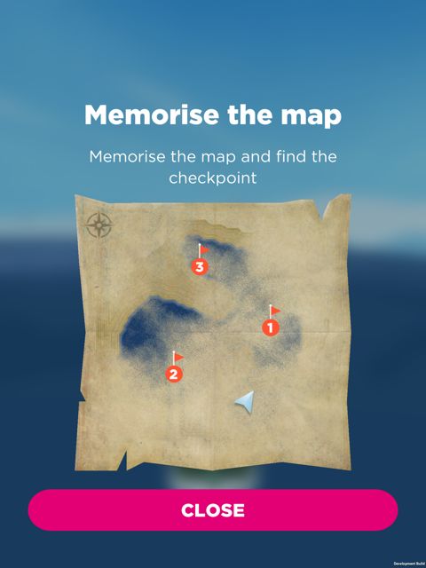
bioRxiv preprint first posted online Apr. 22, 2018; doi: http://dx.doi.org/10.1101/305433. The copyright holder for this preprint
(which was not peer-reviewed) is the author/funder, who has granted bioRxiv a license to display the preprint in perpetuity.
                                  It is made available under a CC-BY 4.0 International license.

                                                                     20

                                                                     18

                                                                     16

                                          Wrong Turns in Real Life
                                                                     14

                                                                     12

                                                                     10

                                                                      8

                                                                      6

                                                                      4

                                                                      2

                                                                      0
                                                                      500   600    700   800   900   1000   1100   1200   1300   1400   1500
                                                                                  Travelled Distance in the Game (pixels)
          Figure 4. Spatial ability at a wayfinding task in real world vs virtual environment

          chose to quantify performance using the number of wrong turns. Wrong turns included going
          into streets that led away from the goal, waling beyond the perimeter set by the experiment and
          being ask to turn round. Across the trials we summed all of the wrong turns to provide a score
          for each participant.

          3      Results
          Performance data for the two tasks was close to being normally distributed (Kolmogorov-Smirnov
          test for the real-world performance: p = 0.46, for the virtual environment performance: p =
          0.06).
          We compared participants’ performance in the game and in real life and found a positive correla-
          tion between the number of wrong turns in our real-world task and the travelled distance in Sea
          Hero Quest (r = 0.62, p < 0.001), see Figure 4. We broke down this global correlation score for
          each Sea Hero Quest level, comparing participants’ performance in real life with the distance they
          travelled in levels 1-6-8-11-16-43, see Figure 5. The correlation coefficient is close to 0 in level
          1, confirming that this instruction level does not measure spatial ability. It then increases with
          level difficulty, before dropping in level 43, suggesting that this level is too hard and participants
          performed homogeneously poorly.

          We also found that in both tasks male participants had an advantage. For comparison purposes
          we scaled the real world and the virtual environment performance between 0 (worst) and 1 (best)
          and found that the gender difference is stronger in the virtual environment (M ± SE males:
          0.54 ± 0.02, females: 0.39 ± 0.05, Cohen’s d = 0.98) than in the real world environment (males:
          0.67 ± 0.06, females: 0.61 ± 0.07, Cohen’s d = 0.22), see Figure 6.

          4      Discussion and future work
          We report preliminary evidence that navigation performance on a mobile app based VR navigation
          task (Sea Hero Quest) is significantly correlated with performance in a real-world city street

                                                                                                     6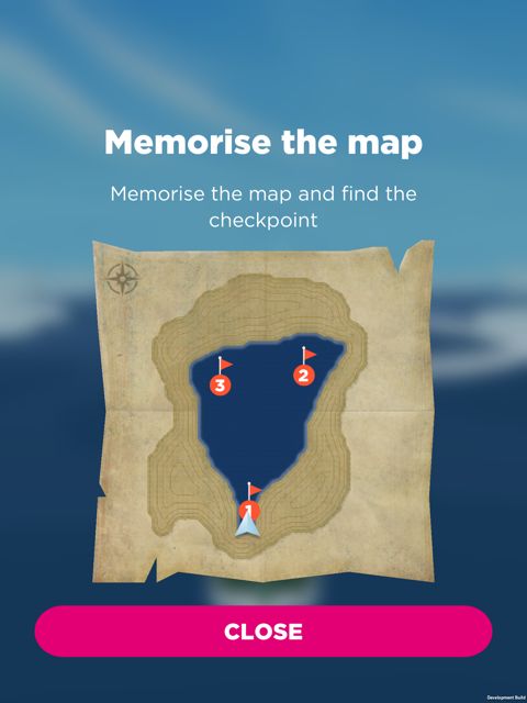
bioRxiv preprint first posted online Apr. 22, 2018; doi: http://dx.doi.org/10.1101/305433. The copyright holder for this preprint
(which was not peer-reviewed) is the author/funder, who has granted bioRxiv a license to display the preprint in perpetuity.
                                  It is made available under a CC-BY 4.0 International license.

          Figure 5. Correlation coefficient between real world performance (number of wrong turns) and
          virtual performance (travelled distance) in levels 1-6-8-11-16-43.

                                            1

                                           0.9

                                           0.8

                                           0.7
                             Performance

                                           0.6

                                           0.5

                                           0.4

                                           0.3

                                           0.2

                                           0.1

                                            0

                                                 Real World - Females   Real World - Males   Virtual - Female   Virtual - Males

                                                                               Environment and Gender

          Figure 6. Gender differences in virtual and real environments. Performance have been scaled
          from 0 (worst) to 1 (best). Dots correspond to individual data points. Error bars correspond to
          95% confidence intervals.

                                                                                         7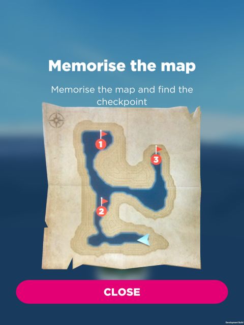
bioRxiv preprint first posted online Apr. 22, 2018; doi: http://dx.doi.org/10.1101/305433. The copyright holder for this preprint
(which was not peer-reviewed) is the author/funder, who has granted bioRxiv a license to display the preprint in perpetuity.
                                  It is made available under a CC-BY 4.0 International license.

          wayfinding task. Given that patients with Alzheimer’s Disease experience real-world wayfinding
          problems early in the disease onset [10, 16, 18, 22], our results provide a useful indication that
          our potential test has real-world ecological validity.

          Our findings are consistent with a number of studies that have compared real-world and VR
          navigation [1–3, 5, 11, 14, 15, 17, 20, 24], and extend the findings to tablet device presentation
          and real world spatial task spanning complex street networks. This is a useful step since it
          increases the ability to remotely test people. This is particularly valuable when certain categories
          of the population have difficulties in mobility, like older people. Currently our results focused on
          young university students. It will be useful to extend to a broader population including older
          participants. Based on this preliminary data and our online data, we will be able to predict
          the average number of wrong turns they will make in our real-world task from their Sea Hero
          Quest test scores (using the levels selected here). An important next step will be to extend this
          preliminary data sample to a larger sample and use another environment to replicate these findings
          in. Future analysis using GPS tracking could potentially provide a more fine-grain analysis of
          errors that goes beyond our current measure of wrong turns. Similarly in future research it will
          be useful to examine how the performance relates to questionnaires about self-rated navigation
          ability, as has been done in recent work [23]. In a follow up study it will also be interesting to
          examine how performance in other levels of Sea Hero Quest (path integration levels and spatial
          working memory levels [4]) relate to this newly developed real-world equivalent task performance.

          References
          1. Astur, R. S., Tropp, J., Sava, S., Constable, R. T., and Markus, E. J. (2004). Sex differences
            and correlations in a virtual morris water task, a virtual radial arm maze, and mental rotation.
            Behavioural brain research, 151(1-2):103–115.
          2. Claessen, M. H., Visser-Meily, J. M., de Rooij, N. K., Postma, A., and van der Ham, I. J.
            (2016). A direct comparison of real-world and virtual navigation performance in chronic stroke
            patients. Journal of the International Neuropsychological Society, 22(4):467–477.
          3. Conroy, R. A. (2001). Spatial navigation in immersive virtual environments. PhD thesis,
            University College London.
          4. Coutrot, A., Silva, R., Manley, E., de Cothi, W., Sami, S., Bohbot, V., Wiener, J., Hölscher,
            C., Dalton, R. C., Hornberger, M., and Spiers, H. (2018). Global determinants of navigation
            ability. bioRxiv, doi:10.1101/188870.
          5. Cushman, L. A., Stein, K., and Duffy, C. J. (2008). Detecting navigational deficits in cognitive
            aging and alzheimer disease using virtual reality. Neurology, 71(12):888–895.
          6. Epstein, R. A., Patai, E. Z., Julian, J. B., and Spiers, H. J. (2017). The cognitive map in
            humans: spatial navigation and beyond. Nature neuroscience, 20(11):1504–1513.
          7. Goeke, C., Kornpetpanee, S., Köster, M., Fernández-Revelles, A. B., Gramann, K., and König,
            P. (2015). Cultural background shapes spatial reference frame proclivity. Scientific Reports,
            5(11426):1–13.
          8. Gordon, B. A., Blazey, T. M., Su, Y., Hari-Raj, A., Dincer, A., Flores, S., Christensen, J.,
            McDade, E., Wang, G., Xiong, C., et al. (2018). Spatial patterns of neuroimaging biomarker
            change in individuals from families with autosomal dominant alzheimer’s disease: a longitudinal
            study. The Lancet Neurology, 17(3):241–250.

                                                                       8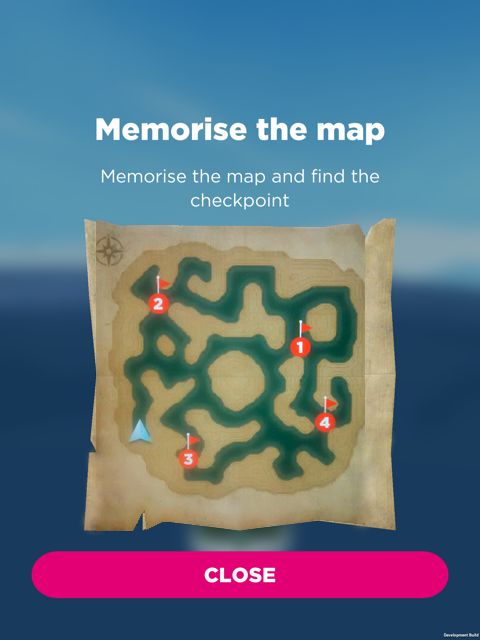
bioRxiv preprint first posted online Apr. 22, 2018; doi: http://dx.doi.org/10.1101/305433. The copyright holder for this preprint
(which was not peer-reviewed) is the author/funder, who has granted bioRxiv a license to display the preprint in perpetuity.
                                  It is made available under a CC-BY 4.0 International license.

          9. Grön, G., Wunderlich, A. P., Spitzer, M., and Tomczak, R. (2000). Brain activation during
            human navigation: gender-different neural networks as substrate of performance. Nature
            Neuroscience, 3(4):404–408.
          10. Lithfous, S., Dufour, A., and Després, O. (2013). Spatial navigation in normal aging and the
            prodromal stage of alzheimer’s disease: insights from imaging and behavioral studies. Ageing
           Research Reviews, 12(1):201–213.
          11. Livingstone, S. A. and Skelton, R. W. (2007). Virtual environment navigation tasks and the
            assessment of cognitive deficits in individuals with brain injury. Behavioural Brain Research,
           185(1):21–31.
          12. Malinowski, J. C. and Gillespie, W. T. (2001). Individual differences in performance on a
            large-scale, real-world wayfinding task. Journal of Environmental Psychology, 21(1):73–82.
          13. Moffat, S. D., Hampson, E., and Hatzipantelis, M. (1998). Navigation in a “Virtual” Maze:
            Sex Differences and Correlation With Psychometric Measures of Spatial Ability in Humans.
           Evolution and Human Behavior, 19(2):73–87.
          14. Richardson, A. E., Montello, D. R., and Hegarty, M. (1999). Spatial knowledge acquisition
            from maps and from navigation in real and virtual environments. Memory & cognition, 27(4):741–
            750.
          15. Ruddle, R. A., Payne, S. J., and Jones, D. M. (1997). Navigating buildings in” desk-top”
            virtual environments: Experimental investigations using extended navigational experience.
           Journal of Experimental Psychology: Applied, 3(2):143–159.
          16. Serino, S. and Riva, G. (2013). Getting lost in alzheimer’s disease: a break in the mental
            frame syncing. Medical Hypotheses, 80(4):416–421.
          17. Sorita, E., N’Kaoua, B., Larrue, F., Criquillon, J., Simion, A., Sauzéon, H., Joseph, P.-A.,
            and Mazaux, J.-M. (2013). Do patients with traumatic brain injury learn a route in the same
           way in real and virtual environments? Disability and Rehabilitation, 35(16):1371–1379.
          18. Tu, S., Spiers, H. J., Hodges, J. R., Piguet, O., and Hornberger, M. (2017). Egocentric
            versus allocentric spatial memory in behavioral variant frontotemporal dementia and alzheimer’s
            disease. Journal of Alzheimer’s Disease, 59(3):883–892.
          19. Tu, S., Wong, S., Hodges, J. R., Irish, M., Piguet, O., and Hornberger, M. (2015). Lost in
            spatial translation–a novel tool to objectively assess spatial disorientation in alzheimer’s disease
            and frontotemporal dementia. Cortex, 67:83–94.
          20. van der Ham, I. J., Faber, A. M., Venselaar, M., van Kreveld, M. J., and Löffler, M. (2015).
            Ecological validity of virtual environments to assess human navigation ability. Frontiers in
           Psychology, 6(637):1–6.
          21. Vashro, L. and Cashdan, E. (2014). Spatial cognition, mobility, and reproductive success in
            northwestern Namibia. Evolution and Human Behavior, 36(2):123–129.
          22. Vlček, K. and Laczó, J. (2014). Neural correlates of spatial navigation changes in mild
            cognitive impairment and alzheimer’s disease. Frontiers in Behavioral Neuroscience, 8(89):1–6.
          23. Weisberg, S. M., Schinazi, V. R., Newcombe, N. S., Shipley, T. F., and Epstein, R. A. (2014).
           Variations in cognitive maps: Understanding individual differences in navigation. Journal of
           Experimental Psychology: Learning, Memory, and Cognition, 40(3):669–682.

                                                                       9
bioRxiv preprint first posted online Apr. 22, 2018; doi: http://dx.doi.org/10.1101/305433. The copyright holder for this preprint
(which was not peer-reviewed) is the author/funder, who has granted bioRxiv a license to display the preprint in perpetuity.
It is made available under a CC-BY 4.0 International license.
24. Wolbers, T. and Hegarty, M. (2010). What determines our navigational abilities? Trends in
Cognitive Sciences, 14(3):138–146.
10You can also read