Snowmelt and snow sublimation in the Indus basin - Preprints ...
←
→
Page content transcription
If your browser does not render page correctly, please read the page content below
Preprints (www.preprints.org) | NOT PEER-REVIEWED | Posted: 26 July 2021
Communication
Snowmelt and snow sublimation in the Indus basin
Simon Gascoin 1
1 CESBIO, Université de Toulouse, CNRS/CNES/IRD/INRAE/UPS, Toulouse, France; simon.gascoin@ces-
bio.cnes.fr
Abstract: The Indus basin is considered as the one with the highest dependence on snowmelt runoff
in High Mountain Asia. The recent High Mountain Asia snow reanalysis enables to go beyond pre-
vious studies by evaluating both snowmelt and snow sublimation at the basin scale. Over 2000-2016,
basin-average snowmelt is 101 11 Gt.a-1 (121 ± 13 mm.a-1), which represents about 25-30% of basin-
average annual precipitation. Snow sublimation accounts for 11% of the mean annual snow abla-
tion, but with a large spatial variability across the basin.
Keywords: snow; snowmelt; snow cover; sublimation; Indus; High Mountain Asia
1. Introduction
Available water resources in the Indus river basin are abstracted almost entirely,
mostly for crop irrigation in Pakistan [1]. Whereas the population and crops are concen-
trated in the low elevation plain of the Indus, a large part of runoff and groundwater re-
charge comes from the high elevation regions of the basin in the Hindu Kush, Karakoram
and the Himalayas [2–4]. This is due to the orographic enhancement of precipitation and
the reduction of evaporative demand with elevation (Figure 1). In the Indus basin, how-
ever, the precipitation trend with elevation is not monotonous because a vast high eleva-
tion region in the north east lies in the rain shadow area of the Himalayas.
In the upper Indus basin, snowmelt is the dominant contributor to water resources,
providing 74% of annual runoff above 2000 m during the period 2001-2014 (23% rainfall,
3% ice melt) [5]. Another study estimated the contribution of snowmelt to annual stream-
flow to 55.4 ± 2.4% [6], but this estimate excluded seasonal snowmelt from glacier area
which may explain the lower percentage. Snowmelt contribution to runoff is also signifi-
cant in the high elevation regions of the Ganges and Brahmaputra basins, but not as much
as in the Indus [5–7]. Above estimates of snowmelt in the Indus basin were obtained using
temperature-index models [5,6]. These empirical models rely on air temperature to com-
pute snowmelt while the energy balance of the snow cover is also controlled by additional
meteorological variables such as shortwave and longwave radiation, wind speed and air
humidity [8,9]. Another limitation of such models is that they do not account for the sub-
limation of the snow cover. Field studies suggest that sublimation can be a significant
component of the snowpack mass balance at the highest elevations of the Himalayas
[10,11].
The recent release of the High Mountain Asia UCLA Daily Snow Reanalysis
(HMASR) [12,13] enables to advance knowledge on snow-related hydrological processes
in the Indus basin. This reanalysis is based on an energy balance model which computes
sublimation [14]. Another advantage is that this reanalysis also correct biases in the pre-
cipitation input data by assimilating remote sensing observations of the snow covered
area [15]. Hence this dataset provides the opportunity to reevaluate snowmelt and to eval-
uate snow sublimation in the Indus basin.
© 2021 by the author(s). Distributed under a Creative Commons CC BY license.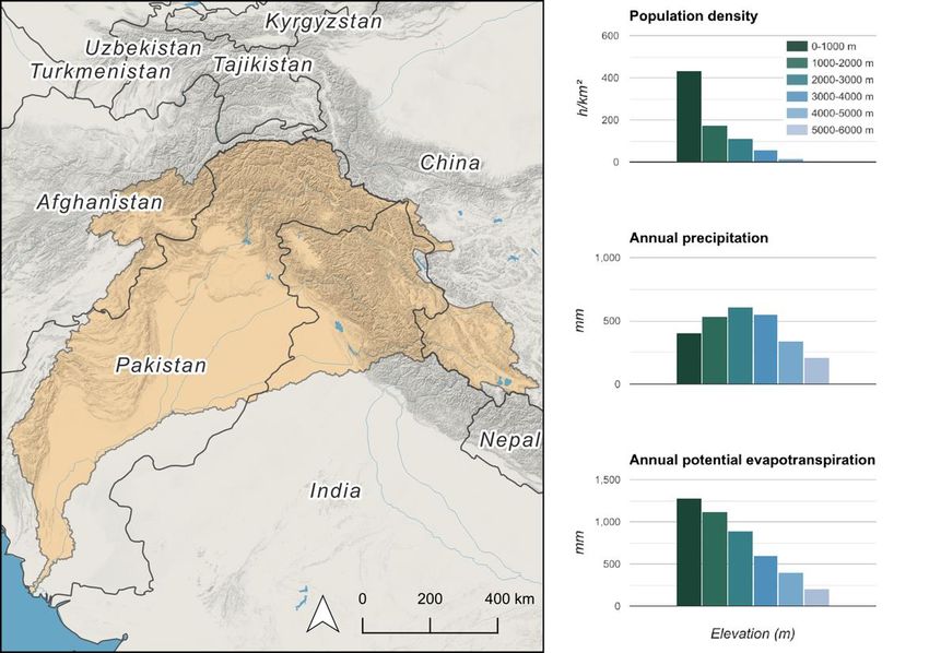
Preprints (www.preprints.org) | NOT PEER-REVIEWED | Posted: 26 July 2021
Figure 1. Indus basin map and distribution of population density, annual precipitation and poten-
tial evaporation by elevation. Data sources: Global Runoff Data Centre [16] (basin polygon modi-
fied in the northeast following [17]), OpenStreetMap (base map), Gridded Population of the
World, Version 4 [18], TerraClimate [19].
2. Materials and Methods
The HMASR provides several snow cover variables (albedo, snow depth, snowmelt,
snow water equivalent and snow sublimation) at a spatial resolution of 16 arc seconds
(~500 m) and a temporal resolution of 1 day. The dataset spans the entire High Mountain
Asia region including the headwaters of the Indus basin. The lower regions of the Indus
basin (tile-average elevation lower than 1500 m) were not processed due to the unlikely
occurrence of snowfall [13]. The dataset covers the period from 01 October 1999 to 30 Sep-
tember 2017.
The HMASR products are distributed by tile of 1° longitude by 1° latitude. Each tile
is a netCDF file containing the daily estimates of a variable over a water year (starting on
01 October) [12]. Using NCO [20], GDAL [21], OTB [22] and GNU parallel [23], I merged
the tiles containing the daily snowmelt and sublimation estimates, cropped the resulting
multiband mosaics to the Indus river basin outline and computed temporal and spatial
averages (source code is provided in the Data availability section). I used the Indus basin
shapefile provided by the Global Runoff Data Centre [16], which I modified to remove a
small region in the northeast following [5,17]. The modified basin has an area of 8.31105
km2 instead of 8.65105 km2. To avoid latitudinal distortion in spatial average computa-
tion, I also resampled the data from their original geographic coordinate system to an
equal area projection system. I used a custom equal area coordinate reference system cen-
tered over the HMA region. Since the objective of this study is to compute basin-averaged
variables and analyze large scale spatial patterns, the resampling method to interpolate
the data on the equal area grid is expected to have a marginal impact on the results. Thus,
I used the nearest neighbor resampling method to reduce the computation cost. The snow-
melt and sublimation were aggregated to daily basin-scale fluxes (units: gigatons per day)
and time cumulated specific fluxes (units: millimeters water equivalent since 01 October)
using the average of all valid pixels in the basin. The resulting timeseries were plotted by
day of water year (DOWY), i.e. day since 01 October. In addition, all the daily products
were aggregated along the time axis to characterize the spatial variability of mean annual
snowmelt and sublimation in the basin. The sublimation ratio was defined as the fraction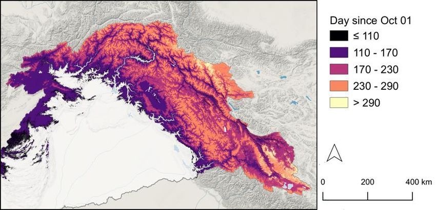
Preprints (www.preprints.org) | NOT PEER-REVIEWED | Posted: 26 July 2021
of snow ablation due to sublimation, where ablation is the sum of snowmelt and sublima-
tion.
3. Results
3.1. Snowmelt
Figure 2 shows that basin-average snowmelt exceeds 100 mm every year except wa-
ter year (WY) 2000-2001. The average annual snowmelt over 2000-2016 (17 water years) is
121 mm with a standard deviation of 13 mm. This corresponds to 101 11 gigatons of
water per year. Snowmelt is minimal in December (between DOWY ~ 60 and ~ 90) and
starts to rise in early February (near DOWY 150). The basin-scale annual maximum daily
snowmelt is reached on DOWY 225, i.e. on 14 May 20 days (standard deviation). How-
ever, Figure 3 shows that peak snowmelt dates vary across the basin depending on eleva-
tion (earlier dates at low elevation) and following an east-west gradient (earlier dates in
the west).
Figure 2. Stacked graphs of cumulated snowmelt and snowmelt timeseries in the Indus basin (the
legend indicates the year of the beginning of the water year)
Figure 3. Median date of the annual maximum daily snowmelt
3.2. Snow sublimation
Figure 4 shows that the total annual sublimation ranges from 10 to 17 mm over the
study period, with an average value standard deviation of 15 2 mm. This corresponds
to 12 2 gigatons of water that return to the atmosphere every year in average. The annual
daily sublimation peak occurs on 15 March 46 days. This is about a month earlier than
the peak snowmelt but with a larger variability since the standard deviation of the annual
maximum date is more than twice the one obtained for the snowmelt. In contrast with
snowmelt, daily sublimation rates are minimal during August (~ DOWY 300 to 330).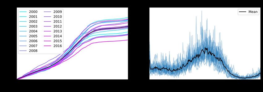
Preprints (www.preprints.org) | NOT PEER-REVIEWED | Posted: 26 July 2021
Figure 4. Stacked graphs of cumulated sublimation and sublimation timeseries in the Indus basin
(the legend indicates the year of the beginning of the water year)
3.2. Contribution of sublimation to snow ablation
Figure 5 shows the relative contribution of snowmelt and sublimation to the seasonal
snow cover ablation. The annual sublimation ratio is relatively stable between 8% and
14% over the study period (average 11%). However, the daily sublimation ratio is highly
variable since it can vary from 0% in August to 50% in December. The sublimation gener-
ally peaked in April, about a month before snowmelt.
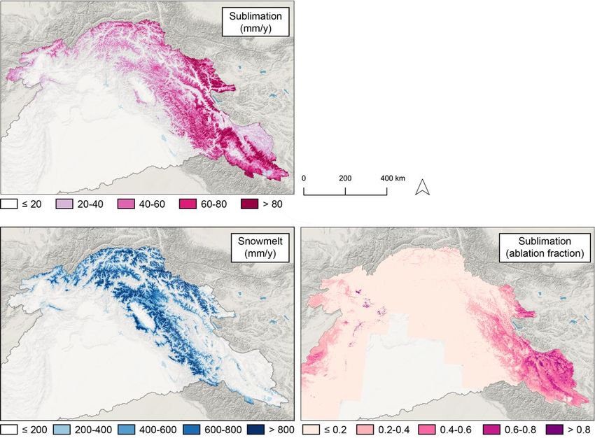
Figure 6 illustrates the spatial variability of snowmelt, sublimation and sublimation
ratio across the mountainous regions of the Indus basin. Both snowmelt and sublimation
exhibit a large spatial variability. Annual snowmelt exceeds 800 mm on the southern
slopes of the Hindu Kush and the Western Himalayas such as the Pir Panjal Range in the
south of the Kashmir valley, the Dhauladhar range (Himachal Pradesh) and the Swat val-
ley (Khyber Pakhtunkhwa). In contrast, largest sublimation values are found in the north
and eastern region of the basin, especially in the high elevation regions of the Karakoram
and the northern slope of the Himalayas (Zanskar, Ladakh). The sublimation ratio is be-
low 0.2 over most of the domain but increases sharply in the northeastern area of the basin,
exceeding 60% over large regions of Ladakh and Western Tibet where annual snowmelt
rate is low and sublimation is high.
Figure 5. Partition of the seasonal snow cover ablation in snowmelt and sublimation. Timeseries of
annual snowmelt and sublimation (left) and timeseries of the mean daily snowmelt and sublima-
tion (right).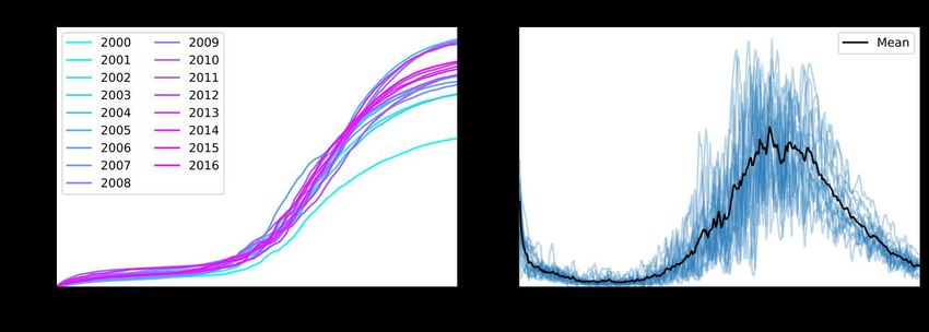
Preprints (www.preprints.org) | NOT PEER-REVIEWED | Posted: 26 July 2021
Figure 6. Maps of the mean annual snowmelt, sublimation and sublimation ratio in the upper In-
dus basin over 2000-2016.
4. Discussion
The mean annual snow ablation (sum of snowmelt and sublimation) is 113 Gt (stand-
ard deviation 12 Gt), which is close but lower than the annual snowfall value of 121.8 ±
7.7 Gt estimated by [6] over the period 1979-2019. This discrepancy can be due to (i) dif-
ferent periods of study (2000-2016 versus 1979-2019) (ii) differences in the basin delimita-
tion [17] (iii) net accumulation of snowfall in the glacier accumulation areas.
The mean annual snowmelt value of 121 13 mm represents a significant but not
dominant fraction of the Indus basin water balance (Figure 7). In comparison, average
basin precipitation from the WorldClim database is 424 mm [24]. Although there is prob-
ably a large uncertainty on this reference precipitation value [3], it falls within the range
of previous estimates (392 to 461 mm) reported by [1]. The basin-average rainfall can be
roughly estimated to 300 mm by subtracting snowmelt and sublimation from this precip-
itation value, which means that snowmelt accounts for about 40% of rainfall in the Indus
basin.
Although snowmelt is lower than rainfall in the Indus basin, it largely exceeds glacier
melt over the same period (2000-2016) [25]. The imbalance ablation (i.e. the release of wa-
ter due to glacier shrinkage) was estimated to 6.2 Gt.a-1. Neglecting glacier mass losses
due to ice and snow sublimation, the glacier imbalance ablation would represent 4% of
the annual snowmelt at the basin scale. The total glacier ablation (17.7 Gt.a-1) from [25] is
also reported in Figure 5 but it is less directly comparable to snowmelt estimated here
because (i) both estimates include the melting of seasonal snowpack on the glacier surface,
(ii) glacier ablation also includes a fraction of sublimation. Also, this study did not use
Indus basin as delimitated by [17].Preprints (www.preprints.org) | NOT PEER-REVIEWED | Posted: 26 July 2021
Figure 7. Maps of the mean annual snowmelt, sublimation and sublimation ratio in the upper In-
dus basin over 2000-2016.
The seasonal cycle of snowmelt is defined by a single peak between May and July
which is similar to previous studies [5,26] but the peak seems to occur earlier than the
snowmelt hydrograph simulated by [26] and it seems to be more concentrated in time
than the one obtained by [5]. In the Indus, snowmelt rates are the high during the summer,
which is also the monsoon season. During that period, the combination of heavy rainfalls
and meltwater runoff can cause flooding [1]. However, snowmelt rates remain high after
the monsoon, hence contributing to sustain river flow after the monsoon flood.
The spatial variability of the peak snowmelt date primarily reflects the effect of ele-
vation but also contrasting climate seasonality between the humid part of the basin in the
west and the arid region in the northeast. This spatial heterogeneity is also evident in the
distribution of the sublimation ratio which is the highest in the dry and cold regions in
the northeast of the basin.
5. Conclusions
The HMASR provides the opportunity to better characterize snow processes and the
hydrological balance in the Indus river basin. Snowmelt is a significant but not dominant
input to the water balance of the Indus river basin over the period 2000-2016. In addition,
the melt season overlaps with the monsoon season, when the issue is more the excess of
water than a lack of water. The data indicate that 11% the seasonal snow is "lost" by sub-
limation over this period. Although the effects of climate change on snow accumulation
and melt in this region are now well understood [6], it remains to evaluate how the subli-
mation fraction could evolve under future climate scenarios.
Data Availability Statement: The HMASR is freely available from the National Snow and Ice Data
Center [12]. This study can be replicated and applied to other river basins of High Mountain Asia
using the scripts provided in this repository: https://github.com/sgascoin/HMA-Snow-Reanalysis-
scripts/tree/1.
Acknowledgments:
Conflicts of Interest: The author declares no conflict of interest
1. Laghari, A.N.; Vanham, D.; Rauch, W. The Indus Basin in the Framework of Current and Future Water Resources Management.
Hydrol. Earth Syst. Sci. 2012, 16, 1063–1083, doi:10.5194/hess-16-1063-2012.
2. Karim, A.; Veizer, J. Water Balance of the Indus River Basin and Moisture Source in the Karakoram and Western Himalayas:
Implications from Hydrogen and Oxygen Isotopes in River Water. J. Geophys. Res. 2002, 107, 4362, doi:10.1029/2000JD000253.Preprints (www.preprints.org) | NOT PEER-REVIEWED | Posted: 26 July 2021
3. Immerzeel, W.W.; Wanders, N.; Lutz, A.F.; Shea, J.M.; Bierkens, M.F.P. Reconciling High-Altitude Precipitation in the Upper
Indus Basin with Glacier Mass Balances and Runoff. Hydrol. Earth Syst. Sci. 2015, 19, 4673–4687, doi:10.5194/hess-19-4673-2015.
4. Ahmad, Z.; Hafeez, M.; Ahmad, I. Hydrology of Mountainous Areas in the Upper Indus Basin, Northern Pakistan with the
Perspective of Climate Change. Environ. Monit. Assess. 2012, 184, 5255–5274, doi:10.1007/s10661-011-2337-7.
5. Armstrong, R.L.; Rittger, K.; Brodzik, M.J.; Racoviteanu, A.; Barrett, A.P.; Khalsa, S.-J.S.; Raup, B.; Hill, A.F.; Khan, A.L.; Wilson,
A.M.; et al. Runoff from Glacier Ice and Seasonal Snow in High Asia: Separating Melt Water Sources in River Flow. Reg. Environ.
Change 2018, doi:10.1007/s10113-018-1429-0.
6. Kraaijenbrink, P.D.A.; Stigter, E.E.; Yao, T.; Immerzeel, W.W. Climate Change Decisive for Asia’s Snow Meltwater Supply. Nat.
Clim. Change 2021, 1–7, doi:10.1038/s41558-021-01074-x.
7. Biemans, H.; Siderius, C.; Lutz, A.F.; Nepal, S.; Ahmad, B.; Hassan, T.; Bloh, W. von; Wijngaard, R.R.; Wester, P.; Shrestha, A.B.;
et al. Importance of Snow and Glacier Meltwater for Agriculture on the Indo-Gangetic Plain. Nat. Sustain. 2019, 2, 594,
doi:10.1038/s41893-019-0305-3.
8. Snow and Climate: Physical Processes, Surface Energy Exchange and Modeling; Armstrong, R.L., Brun, E., Eds.; Cambridge University
Press, 2008; ISBN 978-0-521-85454-2.
9. Stigter, E.E.; Steiner, J.F.; Koch, I.; Saloranta, T.M.; Kirkham, J.D.; Immerzeel, W.W. Energy and Mass Balance Dynamics of the
Seasonal Snowpack at Two High-Altitude Sites in the Himalaya. Cold Reg. Sci. Technol. 2021, 183, 103233,
doi:10.1016/j.coldregions.2021.103233.
10. Stigter, E.E.; Litt, M.; Steiner, J.F.; Bonekamp, P.N.J.; Shea, J.M.; Bierkens, M.F.P.; Immerzeel, W.W. The Importance of Snow
Sublimation on a Himalayan Glacier. Front. Earth Sci. 2018, 6, doi:10.3389/feart.2018.00108.
11. Litt, M.; Shea, J.; Wagnon, P.; Steiner, J.; Koch, I.; Stigter, E.; Immerzeel, W. Glacier Ablation and Temperature Indexed Melt
Models in the Nepalese Himalaya. Sci. Rep. 2019, 9, 5264, doi:10.1038/s41598-019-41657-5.
12. Liu, Y.; Fang, Y.; Margulis, S.A. High Mountain Asia UCLA Daily Snow Reanalysis 2021.
13. Liu, Y.; Fang, Y.; Margulis, S.A. Spatiotemporal Distribution of Seasonal Snow Water Equivalent in High-Mountain Asia from
an 18-Year Landsat-MODIS Era Snow Reanalysis Dataset. Cryosphere Discuss. 2021, 1–25, doi:10.5194/tc-2021-139.
14. Margulis, S.A.; Girotto, M.; Cortés, G.; Durand, M. A Particle Batch Smoother Approach to Snow Water Equivalent Estimation.
J. Hydrometeorol. 2015, 16, 1752–1772, doi:10.1175/JHM-D-14-0177.1.
15. Liu, Y.; Margulis, S.A. Deriving Bias and Uncertainty in MERRA-2 Snowfall Precipitation Over High Mountain Asia. Front. Earth
Sci. 2019, 7, doi:10.3389/feart.2019.00280.
16. BfG - The GRDC - Major River Basins of the World - Major River Basins of the World, 2nd Ed. (GRDC, 2020) Available online:
https://www.bafg.de/GRDC/EN/02_srvcs/22_gslrs/221_MRB/riverbasins_2020.html;jsessionid=654401DB461D8774CCEE33021
A528DD7.live21301?nn=201762#doc2731742bodyText7 (accessed on 23 July 2021).
17. Khan, A.; Richards, K.S.; Parker, G.T.; McRobie, A.; Mukhopadhyay, B. How Large Is the Upper Indus Basin? The Pitfalls of
Auto-Delineation Using DEMs. J. Hydrol. 2014, 509, 442–453, doi:10.1016/j.jhydrol.2013.11.028.
18. Center For International Earth Science Information Network-CIESIN-Columbia University Gridded Population of the World,
Version 4 (GPWv4): Population Density, Revision 11 2017.
19. Abatzoglou, J.T.; Dobrowski, S.Z.; Parks, S.A.; Hegewisch, K.C. TerraClimate, a High-Resolution Global Dataset of Monthly
Climate and Climatic Water Balance from 1958–2015. Sci. Data 2018, 5, 170191, doi:10.1038/sdata.2017.191.
20. Zender, C.S. Analysis of Self-Describing Gridded Geoscience Data with NetCDF Operators (NCO). Environ. Model. Softw. 2008,
23, 1338–1342, doi:10.1016/j.envsoft.2008.03.004.
21. OSGeo/Gdal; Open Source Geospatial Foundation, 2021;
22. Grizonnet, M.; Michel, J.; Poughon, V.; Inglada, J.; Savinaud, M.; Cresson, R. Orfeo ToolBox: Open Source Processing of Remote
Sensing Images. Open Geospatial Data Softw. Stand. 2017, 2, 15, doi:10.1186/s40965-017-0031-6.
23. Tange, O. Gnu Parallel 20150322 ('Hellwig’); Zenodo, 2015;Preprints (www.preprints.org) | NOT PEER-REVIEWED | Posted: 26 July 2021
24. Hijmans, R.J.; Cameron, S.E.; Parra, J.L.; Jones, P.G.; Jarvis, A. Very High Resolution Interpolated Climate Surfaces for Global
Land Areas. Int. J. Climatol. 2005, 25, 1965–1978, doi:10.1002/joc.1276.
25. Miles, E.; McCarthy, M.; Dehecq, A.; Kneib, M.; Fugger, S.; Pellicciotti, F. Health and Sustainability of Glaciers in High Mountain
Asia. Nat. Commun. 2021, 12, 2868, doi:10.1038/s41467-021-23073-4.
26. Kraaijenbrink, P.D.A.; Stigter, E.E.; Yao, T.; Immerzeel, W.W. Climate Change Decisive for Asia’s Snow Meltwater Supply. Nat.
Clim. Change 2021, 11, 591–597, doi:10.1038/s41558-021-01074-x.You can also read