Probabilistic Modelling of Icebergs in the Russian Arctic Seas
←
→
Page content transcription
If your browser does not render page correctly, please read the page content below
IOP Conference Series: Earth and Environmental Science

PAPER • OPEN ACCESS

Probabilistic Modelling of Icebergs in the Russian Arctic Seas
To cite this article: O Sabodash et al 2019 IOP Conf. Ser.: Earth Environ. Sci. 272 022088

View the article online for updates and enhancements.

                               This content was downloaded from IP address 46.4.80.155 on 16/05/2021 at 21:19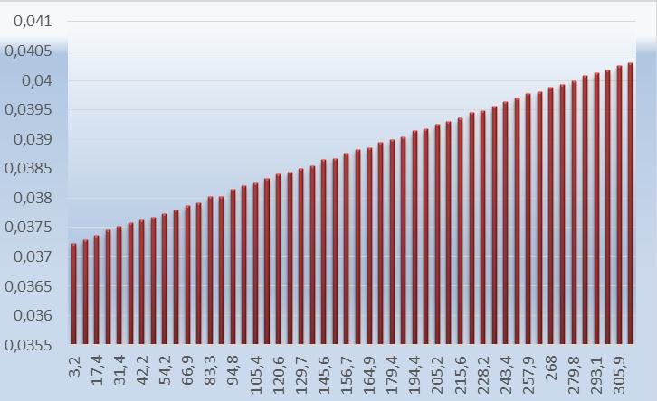
International science and technology conference "Earth science"                                                IOP Publishing
IOP Conf. Series: Earth and Environmental Science 272 (2019) 022088                        doi:10.1088/1755-1315/272/2/022088

Probabilistic Modelling of Icebergs in the Russian Arctic Seas

                     O Sabodash1, S E Zagorodnyaya1, Yu A Krikunova2
                     1
                       School of Engineering, Far Eastern Federal University, 8, Sukhanova Street,
                     Vladivostok, 690092, Russia
                     2
                       School of Regional and International Studies, Far Eastern Federal University, 8,
                     Sukhanova Street, Vladivostok, 690092, Russia

                     E-mail: sabodash.oa@dvfu.ru

                     Abstract. The paper aims at providing safe development of oil and gas deposits in the offshore
                     area of the Kara and Barents seas where promising hydrocarbon deposits are located. For these
                     water areas marine oil and gas structures construction projects are designed, primarily in
                     connection with the plans for oil and gas fields’ development. Icebergs belong to such kind of
                     drifting ice features, the action of which in most cases neither floating, nor stationary marine
                     hydraulic structures can withstand.
                     The danger of a large drifting iceberg effect on exploration and production platforms, oil and
                     gas pipelines is obvious, therefore, the iceberg – structure hit probability prediction is of great
                     applied importance.
                     The aim of the paper is probabilistic modelling of icebergs to prevent their collision with
                     structures, the Kara and Barents seas taken as an example.

1. Introduction
Continental shelf of Kara and Barents seas is the world’s largest source of unexplored hydrocarbon
resources. Natural features of this region directly affect implementation of projects. Thus, in the Kara
Sea water depth is 40–350 metres, ice conditions are as follows: ice holds up 10 months a year, its
thickness reaches one and a half metres, and winter temperature is around 46˚С below zero. In
addition, water areas of Barents and Kara seas feature hummocks, stamukhas and icebergs
[1,3,8,13,16].
    Ice features study is a necessary condition of design, construction and operation of structures in the
arctic seas offshore area. However, so far ice features, including hummocks, multiyear ice floes,
stamukhas and icebergs in the Russian arctic seas water areas have not been studied fully enough.
Icebergs are one of the most dangerous elements of natural environment both for navigation and for
functioning of engineering structures and service lines located in the offshore zone of arctic and
subarctic seas. Without taking into consideration this phenomenon the development of natural
resources entails high risk both from the point of view of maritime safety and oil&gas production and
from the point of view of limitation of damage caused to the natural environment by possible iceberg –
structure collisions in sea [10]. Currently, in Russian practice [14] there are no techniques for
calculating force impact of icebergs on marine hydraulic structures. Foreign design codes [7,9] contain
only approximate methods of evaluating icebergs impact on structures based on probabilistic and
statistical methods.

              Content from this work may be used under the terms of the Creative Commons Attribution 3.0 licence. Any further distribution
              of this work must maintain attribution to the author(s) and the title of the work, journal citation and DOI.
Published under licence by IOP Publishing Ltd                          1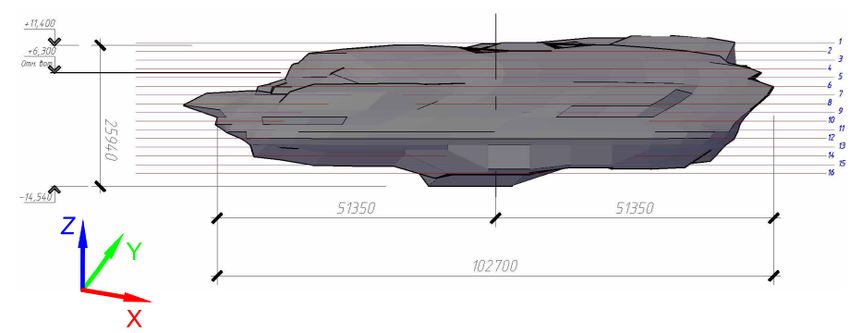
International science and technology conference "Earth science"                           IOP Publishing
IOP Conf. Series: Earth and Environmental Science 272 (2019) 022088   doi:10.1088/1755-1315/272/2/022088

   Thereby, it seems promising on the basis of field material obtained by several researchers in recent
years to assess morphometric characteristics of ice features and their internal structure as well as to
evaluate the danger for facilities in the offshore area of the Russian arctic seas caused by icebergs.
   The aim of the paper is probabilistic modelling of icebergs to prevent their collision with structures,
the Kara and Barents seas taken as an example.
   The main tasks are: probabilistic analysis of morphological and kinematic parameters of icebergs in
the promising areas of the deposits; tabular iceberg theoretical model development on the basis of
CAD–technologies; probabilistic modelling of iceberg – structure collision for developing schemes of
iceberg towing in the regions of promising hydrocarbon deposits in the offshore area of the Kara and
Barents seas.

2. Background of problem
A common definition of iceberg is as follows: a massive broken off from a glacier fragment of an ice
feature of random shape which, as a rule, is more than 5 m above sea level and can be either afloat or
aground [2]. Icebergs are distributed on the territory constituting around 20% of World Ocean area;
they have a great range of shapes and dimensions. In northern latitudes large icebergs are 200 m in
diameter and 25 m above sea level; their underwater part has up to 200 m draught. Icebergs 1-5 m
above sea level are called floebergs, icebergs less than 1 m is growlers. Depending on water density
87-90% of iceberg is underwater [16].
   In the Kara Sea the main sources of icebergs formation are the Severnaya Zemlya and Novaya
Zemlya archipelagos [2]. The length of the largest outlet glaciers is 50–56 kilometres; the area is more
than 1000 square kilometres (Nordenskiöld Glacier on the Novaya Zemlya). It is known that the
largest number of icebergs in the Barents Sea is registered near the sources of their formation – the
Franz Josef Land, Spitsbergen and Novaya Zemlya archipelagos. But during certain years icebergs
may spread far south and reach Norwegian and Russian coasts. The detailed description of such
extreme cases based on the analysis of various sources is given in paper [3].
   Figure 1 shows the scheme of icebergs repeatability and distribution lines in the Kara Sea [16].

Figure 1. Icebergs repeatability lines in the Kara Sea (according to the data for the period from 1928
to 1991) and distribution of icebergs registered in 1% repeatability area.

                                                     2
International science and technology conference "Earth science" IOP Publishing
IOP Conf. Series: Earth and Environmental Science 272 (2019) 022088 doi:10.1088/1755-1315/272/2/022088
A significant parameter for designing is icebergs shapes repeatability in the region of promising
deposits [2]. Foreign and Russian researchers from 1988 to 1992 in the Norwegian sector of the
Barents Sea registered 8 varieties of icebergs shapes: floeberg, tabular iceberg, growler, pyramidal
iceberg, dome-shaped iceberg, rounded iceberg, inclined slopе-shaped iceberg and breaking iceberg
[1,3,8]. Analysis reveals that the most common shapes of icebergs in the Kara Sea are floebergs and
tabular icebergs.
Statistical characteristics of morphometric shapes of icebergs depending on year are given in tables
1–3 [13]. Characteristic calculated parameters of iceberg shapes are:
- iceberg height above sea level;
- iceberg waterline breadth;
- iceberg waterline length;
- iceberg’s keel draught.
As research results showed [13], empirical data of height, breadth and length of icebergs are well
approximated by lognormal distribution with parameters given in tables 1-3. The data on iceberg’s
keel draught are given in paper [3]. According to the definitions [3], the prevailing shape of icebergs
in the Barents Sea is floebergs and growlers. The area along the waterline of such icebergs does not
exceed 300 square metres, their height does not exceed 5 m, and their mass is 11 thousand tons.
Therefore, the draught of floebergs and growlers does not exceed 22 m. Mean draught of icebergs
(except floebergs and growlers) is 50 m at standard deviation of 28 m, (interquartile range) is from 30
to 70 m.
Iceberg height. Statistical characteristics of yearly icebergs heights distributions are given in table
1.
Table 1. Icebergs heights distribution, 2003–2009
Year of observation
Characteristic, metres 2003 2004 2005 2006 2007 2008 2009
Mean value 9,4 4,3 11,1 7,7 11,2 16,2 12,5
Minimum /maximum 5/ 1,6/ 2/ 2/ 2/ 9/ 2/
20,8 13,2 33,8 25,3 30,0 45,0 27,2
Standard deviation 4,2 3,0 6,7 4,8 5,9 11,6 6,1
Iceberg breadth. Yearly icebergs breadths distributions are given in table 2.
Table 2. Icebergs breadths distribution, 2003–2009
Year of observation
Characteristic, metres 2003 2004 2005 2006 2007 2008 2009
Mean value 57,0 15,3 44,5 36,2 57,6 91,0 47,4
Minimum /maximum 10/ 2/ 5/ 4/ 5/ 30/ 10/
200 46 210 245 315 163 234
Standard deviation 50,4 11,1 35,5 41,7 49,2 67,2 39,0
Icebergs length. Yearly icebergs lengths distributions are given in table 3.
Table 3.Icebergs lengths distribution, 2003–2009
Year of distribution
Characteristic, 2003 2004 2005 2006 2007 2008 2009
metres
Mean value 84,1 24,2 71,4 65,1 89,1 121,7 97,9
Minimum 10/ 5/ 5/ 5/ 5/ 40/ 10/
/maximum 430 166 414 749 933 330 463
Standard deviation 85,6 23,2 64,9 83,6 105,3 96,1 78,5
3International science and technology conference "Earth science" IOP Publishing
IOP Conf. Series: Earth and Environmental Science 272 (2019) 022088 doi:10.1088/1755-1315/272/2/022088
3. Geometrical model
Actual iceberg shape consideration is one of the most complicated and formidable tasks while
designing structures and navigation operations scheduling in the arctic seas. This is explained by the
fact that icebergs have various and random shapes difficult to observe, predict and somehow take into
consideration in engineering design. Besides, in spite of an almost 100-years long history of icebergs
observations, there is still no reliable data base on icebergs shapes. Nevertheless, information on
icebergs physical shapes and drift is of great applied importance, particularly, it is used for iceberg –
offshore structures hit probability estimation as well as for prevention of such hits and development of
sea operations on icebergs towing tactics [4].
In available literary sources icebergs shapes are described by idealized geometric figures and in
most cases are far from the reality. Thus, for instance, in the paper [13] tabular icebergs are simulated
as a prism, floebergs – as a cone, spherical segment or ellipsoid of revolution segment. As a rule, in
these elementary iceberg models keel draught is unreasonably overestimated, while the wetted
perimeter of the underwater part, the mass and volume of iceberg are, on the contrary, underestimated,
which leads to substantial structural loads miscalculations.
The solution to the problem is seen in using up-to-date computer technologies, application software
for modeling solid-state objects in CAD-systems, such as AutoCAD.
The improved iceberg models proposed by authors aim at correcting loads from these ice features
on offshore structures and vessels; they can also be used for towing icebergs in other programs of ice
management.
This calculation offers iceberg projections and shapes for calculating iceberg – platform hit
probability and for iceberg towing. Figures 2 and 3 show tabular iceberg shapes models built with the
aid of AutoCAD software. As the initial data for geometric modeling the statistical parameters of
icebergs were chosen which are presented in tables 1-3 and in papers [3,16].
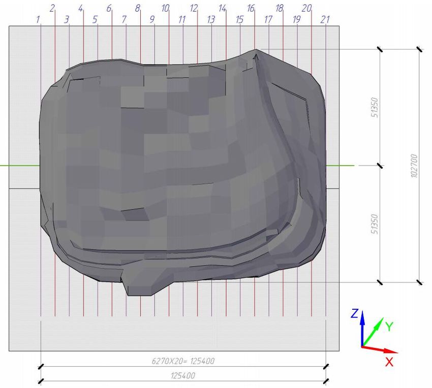
Figure 2. Three-dimensional model of tabular iceberg shape (top view).
Figures 4 and 5 give geometric parameters of iceberg with dimensions 102.7×125.4×25.94m,
accepted further for iceberg – structure hit probability calculation and subsequent iceberg towing in
the water areas of the Barents and Kara seas.
4. Probabilistic model
One of the tasks is assessment of iceberg danger for platforms being installed in the water areas where
icebergs occurrence is possible.
From the designing point of view iceberg – platform collision should be considered as a special
load. Design codes [7] indicate that for collision prevention it is necessary to provide such activities as
towing or stopping by a vessel.
Besides, collisions should be taken into consideration even in case of towing. Thus, iceberg towing
is the most effective method of managing ice situation in the water area.
4International science and technology conference "Earth science" IOP Publishing
IOP Conf. Series: Earth and Environmental Science 272 (2019) 022088 doi:10.1088/1755-1315/272/2/022088
Figure 3. Three-dimensional model of tabular iceberg shape (side view).
Figure 4. Transverse section scheme of tabular iceberg shape (top view).
5International science and technology conference "Earth science" IOP Publishing
IOP Conf. Series: Earth and Environmental Science 272 (2019) 022088 doi:10.1088/1755-1315/272/2/022088
Figure 5. Longitudinal section scheme of tabular iceberg shape (side view).
Currently more than 1500 towing operations have been registered in the waters of arctic offshore
area [12].
The characteristics of iceberg danger can serve:
- platform – iceberg hit probability in the course of one year;
- hit probability in the course of year with the iceberg having dimensions or mass not less than
specified value;
- hit probability in the course of year with the iceberg having kinetic energy not less than specified;
- probability for the iceberg approaching the platform to distance L to hit the platform;
- hit probability with the iceberg in the course of year when global load on the platform will be not
less than specified, etc.
It should be noted that “probabilistic” design is referred to in the last definition from the above
mentioned list describing possible factors of iceberg danger. Iceberg – platform contact interaction
resultant load greatly depends on shape characteristics of the iceberg surface local segment directly
coming in contact with platform body.
Paper [5] notes that hit probability with iceberg (or more exactly, estimated probability, calculated
on the basis of available statistical information with the aid of one or another probabilistic model)
cannot of itself give comprehensive information for offshore platform design implementation.
Indeed, if only small icebergs’ (or their fragments’) occurrence is possible in the offshore field
zone, the corresponding calculated situation, apparently, will not be crucial for designing. If there are
reasons to expect, though not very often, the occurrence of large icebergs, this design situation should
be taken into consideration. For instance, in is possible to calculate such characteristics as platform –
iceberg hit probability during the given period of time. The iceberg should have kinetic energy not less
than the given value [9].
It should be mentioned that the design situation of platform – iceberg collision is a rare event. It
means that an actual structure, whose service life in most cases is 25-50 years, will practically never
be exposed to iceberg impact. Nevertheless, hit probability is more than zero.
In this paper the probability for the iceberg approaching the platform to the distance L, to hit the
platform is calculated. For modeling iceberg danger various probabilistic approaches can be used [5].
In most of them Monte-Carlo statistic modeling technique is applied.
For the probabilistic modeling the initial data of iceberg breadth given in table 2 were chosen [13].
At the first stage according to Monte-Carlo method a series of iceberg breadths amounting N=1000
values was modeled under lognormal distribution function (figure 6). As a result of modeling the
following series statistical characteristics Pa B were obtained: breadth mean value m=30.8 m,
standard deviation =41.9 m.
6International science and technology conference "Earth science" IOP Publishing
IOP Conf. Series: Earth and Environmental Science 272 (2019) 022088 doi:10.1088/1755-1315/272/2/022088
According to the authors’ calculation data, the breadth of tabular iceberg 1% probability in Kara
and Barents seas makes up 240.5m.
At the second stage iceberg – structure hit probability was calculated depending on its breadth.
When values for all variables were determined, hit probability was calculated on the equation
according to the «rain drop» model [11], and for N simulations it is defined by expression:
F W Dk W Dk 1
p k N (1)
H W Da N
W Dk
k 1
where W is structure’s width, m; Dk is ice feature’s diameter, m; Da is ice feature’s mean diameter, m.
Equation (1) takes into account higher expectancy of hitting for large icebergs than for small ones.
Iceberg – structure hit probability distribution bar chart is given in figure 7. For probabilistic analysis
out of the series of N=1000 values 50 iceberg breadth values were selected as the most dangerous for
structure in case of collision.
At the third stage joint event probability – the appearance of k–wide iceberg in the given water area
zone, Рa(B), and its collision with the structure, Рhit(В), was determined on the basis of conditional
probability theorem use [15]. The probability of the fact that k–wide iceberg occurs and hits the
structure is determined according to probability multiplication theorem. It follows from the theorem
that probability of joint events is equal to unconditional probability of the first event (in our case
probability Рa(B)), multiplied by conditional probability of the second event (in our case probability
F
p k ), calculated on condition that the first event took place:
H
F
Phit Pa B p k (2)
H
The analysis of iceberg breadth probabilistic distributions (figure 6) and iceberg joint occurrence
and structure hit probability (figure 8) showed good agreement with icebergs statistical data obtained
by [13,16].
Hit probability of design iceberg with dimensions 102.7×125.4×25.94m with the structure made up
0.004 (figure 8). Data analysis of figure 8 shows that iceberg – structure hit probability grows as
iceberg breadth increases. Consequently, we can draw the conclusion that icebergs more than 50m
wide represent the greatest danger. Further, breadth values of 50-240m may be used for icebergs
towing calculations and for ice management techniques development.
Iceberg breadth, m
Figure 6. Histogram of icebergs occurrence probability Pa B in the water area.
7International science and technology conference "Earth science" IOP Publishing
IOP Conf. Series: Earth and Environmental Science 272 (2019) 022088 doi:10.1088/1755-1315/272/2/022088
Iceberg breadth, m
F
Figure 7. Histogram of icebergs – structure hit probability p k .
H
Iceberg breadth, m
Figure 8. Histogram of joint event probability: icebergs occurrence and hitting the structure Phit .
5. Conclusions
The article presents morphological and kinematic parameters investigation analysis of icebergs in
promising deposit areas of Russian Arctic. Icebergs shapes are described according to the
classification met in paper of [16] and other researchers.
Theoretical model of tabular iceberg has been developed on the basis of AutoCAD software. The
theoretical model was generated on the basis of statistical observations data of icebergs parameters
such as breadth, height, length over the period of 2003-2009.
Iceberg – structure hit probabilistic modeling was carried out by Monte-Carlo method, and ice
situation management techniques are presented. For probabilistic modeling icebergs breadth
parameters were chosen. Iceberg breadth series of value number N=1000 was modeled by Monte-
Carlo method under lognormal distribution law.
Data analysis has shown that iceberg – structure hit probability grows as iceberg breadth increases.
Consequently, we can draw the conclusion that icebergs more than 50 m wide represent the greatest
danger.
As a result, design sizes of icebergs have been chosen for calculating their towing and ice
management operations.
8International science and technology conference "Earth science" IOP Publishing
IOP Conf. Series: Earth and Environmental Science 272 (2019) 022088 doi:10.1088/1755-1315/272/2/022088
6. References
[1] Abramov V 1992 Russian Iceberg Observations in the Barents Sea, 1933-1990 Polar Research
vol 11 2 p 93-97
[2] Borodulin V V 2009 Some Data of Glaciers Frontal Zones Aerial Photography of the Franz
Josef Land and Novaya Zemlya (AARI Transactions vol 450) p 132–136
[3] Buzin I V 2008 Icebergs and Glaciers of the Barents Sea: Latest Investigations. Part 1. Main
Producing Glaciers, Distributions and Morphometric Features of Icebergs (Problems of the
Arctic and the Antarctic № (1) 78) p 66-79
[4] Dementyev A A 1997 Climatic Conditions of Iceberg Formation and Drift in the Barents and
Kara seas (AARI Transactions vol 439) p 197–215
[5] Dunwoody А В 1983 The Design Ice Island for Impact against an Offshore Structure Proc. 15th
Offshore Technology Conference vol 2 p 325-330 4550 (Houston, TX)
[7] GL 2005. Guideline for the Construction of Fixed Offshore Installations in Ice Infested Waters
(Germanischer Lloyd Oil and Gas GmbH. Rules and Guidelines. Industrial Services) 29
[8] Gudoshnikov Yu P 1995 Iceberg Danger Estimation for Certain Areas of the Barents Sea. Brief
Outline Report II Int. Conference “Russian Arctic offshore development”(Spb.: SpbSTU) p
110–111
[9] ISO/FDIS 19906:2010(E) 2010 Petroleum and Natural Gas Industries – Arctic Offshore
Structures, Final Draft (International Organization for Standardization, ISO TC 67 / SC 7) 474 p
[10] Mathiesen M 1992 Iceberg Collision - Risk Analysis (Report on Project № 605254) 42
[11] Nevel D E 1989 Probabilistic Ice Forces on Offshore Structures. IAHR/IUTAM Symposium of
Ice-Structure Interaction (St. John's)
[12] Rudkin P, Boldrick C and Barron Jr P 2005 PERD Iceberg Management Database. PERD/ CHC
Report 20–72, Report prepared by Provincial Aerospace Environmental Services (PAL) (St.
John's, NL) 71
[13] Skutin А А 2011 The Barents Sea Icebergs Morphometric Characteristics Estimation over Full-
Scale Data for their Drift Simulation Int. Conference RAO-2011 (Spb)
[14] SP 38.13330.2012 2012 Loads and Effects on the Waterworks (Wave, Ice and from Ships), the
updated edition of SNiP 2.06.04-82*, (Moscow: Minregionrazvitiya) 116
[15] Vadzinskii R N 2001 Probabilistic Distributions Handbook (Spb: Nauka) p 186-190
[16] Zubakin G K, Gudoshnikov Yu P, Naumov А К, Buzin I V, Skutin А А and Skutinа Е А 2006
Ice Features of Western Arctic Seas: Monograph (Spb: AARI) 272
9You can also read