Small Stream Ecosystem Variability in the Sierra Nevada of California
←
→
Page content transcription
If your browser does not render page correctly, please read the page content below
Small Stream Ecosystem Variability
in the Sierra Nevada of California
Carolyn T. Hunsaker, Sean M. Eagan
Abstract                                                     Introduction

The quality of aquatic and riparian ecosystems is a          Sixty percent of California’s water originates from
function of their condition and the integrity of adjacent    small streams in the Sierra Nevada, yet very little
uplands in their watersheds. While small streams make        information is known about how these streams are
up a large proportion of the overall stream network, our     affected at the source. This water is considered some of
knowledge of how they function is still limited. The         the highest quality water in the state. The quality of
Kings River Experimental Watershed (KREW) was                aquatic and riparian (near-stream) ecosystems
initiated in 2000 to quantify the variability in             associated with streams is directly related to the
characteristics of small stream ecosystems and their         condition of adjacent uplands within their watersheds.
associated watersheds in the Sierra Nevada of                The degradation of forest streams and their associated
California. The primary management questions to be           watersheds is often the result of nonpoint sources such
answered are the effects of prescribed fire and              as past timber harvesting, roads, fire suppression, and
mechanical thinning on the riparian and stream               catastrophic wildfires. Restoration of the Sierra
physical, chemical, and biological conditions.               Nevada’s forest watersheds to historic or desired
                                                             conditions requires active management such as
Two mixed conifer sites are being developed. Data will       reintroduction of frequent, cool fires and removal of
be gathered for at least a 3-year reference period. After    accumulated fuel loads.
fire and harvest treatments are applied, data will be
gathered for at least seven years. Each site has a control   The Kings River Experimental Watershed (KREW) is a
watershed that receives no treatments, a watershed that      long-term watershed research study being designed and
is burned, a watershed that is harvested, and a              implemented on the Sierra National Forest to provide
watershed that is both burned and harvested. We are          much needed information for forest management plans
interested in assessing the integrated condition of the      regarding water quantity and quality. This experimental
streams and their associated riparian and watershed          watershed research is designed to: (1) quantify the
areas (i.e., physical, chemical, and biological              variability in characteristics of headwater stream
characteristics). The watersheds range in size from 49       ecosystems and their associated watersheds, and (2)
to 228 ha (120 to 562 acres); a size that can be             evaluate the effect of fire and fuel-reduction treatments
consistently treated.                                        on the riparian and stream physical, chemical, and
                                                             biological conditions. This is an integrated ecosystem
Keywords: stream ecosystem, watershed                        project at the watershed scale and is part of a larger
experiment, prescribed fire, mechanical thinning,            adaptive management study that began in 1994 as a
sustainable forests                                          collaborative effort between the Sierra National Forest,
                                                             Southern California Edison, and the Pacific Southwest
                                                             Research Station of the Forest Service to evaluate the
                                                             effects of approaches for creating an uneven-aged
                                                             forest similar to that present before European
                                                             settlement, circa 1850. The experiment will implement
                                                             mechanical thinning, prescribed fire, and thinning with
                                                             fire combination treatments on headwater areas.

                                                             "Aquatic/riparian systems are the most altered and
Hunsaker is a Research Ecologist and Eagan is a              impaired habitats of the Sierra" (University of
Hydrologist, both with the U.S. Department of                California, Davis 1996). However, what is considered
Agriculture, Forest Service, Pacific Southwest               appropriate management for such ecosystems is
Research Station, Sierra Nevada Research Center,             currently a point of debate and quantitative information
Fresno, CA 93710. E-mail: chunsaker@fs.fed.us.
716
is needed (USDA Forest Service 2001). While and D102 (Figure 1). A grid with 150-m (492-ft)
watershed research and stream monitoring have been spacing has been placed within each watershed; for the
ongoing, much of the work addresses larger streams. small size of P304 the grid was densified in the north-
Much of the information on effects from forest south directions with a 75-m (246-ft) spacing.
management activities likely is not applicable for Sampling for physical soil characteristics, upland
Sierran forests because it comes from wetter forests vegetation, and fuel loads are all located using this
and severe treatments (e.g., clearcuts and wildfire). grid. All measurements are made in the same manner at
Also, few integrated ecosystem studies exist; these are both sites, but the Providence Site has evolved to have
essential for understanding stream/watershed more types of measurements (i.e., sediment ponds in
ecosystem processes and functions for adaptive the streams, sediment fences to quantify upland
management, thus critical information is lacking erosion, vacuum lysimeter collectors for shallow soil
(Naiman and Bilby 1998). water, and riparian microclimate).
Methods Stream discharge is measured using two fiberglass
Parshall-Montana flumes in each stream, a large and a
The KREW recognizes that measurements of physical, small, because the streams have approximately a 500-
chemical, and biological variables are necessary to fold difference between lowest and highest flow for a
accomplish a holistic watershed study and has carefully 20-year time span. We can measure precisely flows
tried to include those attributes critical to detect change from 0.75 l/s (0.03 cfs) to 900 l/s (32 cfs) and with less
in both patterns and processes in atmospheric inputs, precision flows from 0.3 l/s (0.01 cfs) to 1,400l/s (49
watershed uplands and riparian areas, and stream cfs). These flumes are good at passing debris and do
channels. Human actions jeopardize the biological not require large upstream ponds to accurately measure
integrity of water resources by altering one or more of flow. Stage is measured with the Isco 730 bubbler;
five principal factors: physical habitat, seasonal flow Sequoia Scientific Aquarods provide backup data for
of water, the food base of the system, interactions stage measurements.
within the stream biota, and chemical contamination
(Karr 1998). We are taking measurements for each of Measuring the seasonal variation in air temperature,
these factors. solar radiation, and precipitation is considered basic to
all hydrologic and natural resource studies (Hanson et
The experimental watershed is planned as a 15-year al. 2001). Each site has a high elevation and a low
study and has two sites, the Providence Creek Site and elevation meteorological station with a 6 m (20 ft)
the Bull Creek Site, located in mixed-conifer forest tower, a precipitation gage, and a telemetry antenna.
between 1,500 (5,000 ft) and 2,134 m (7,000 ft) The high elevation stations also have a snow pillow to
elevation on granitic-based soils. As such, these sites measure snow water equivalence. Each tower has
are very typical of the central Sierra Nevada and instruments to measure relative humidity, temperature,
forested headwaters that provide a substantial amount wind speed, wind direction, wind run, solar radiation,
of source water to the San Joaquin River basin of and snow depth.
California. The Providence Site typically experiences
rain and snow events while the higher elevation Bull Universal physical laws govern streams, yet every
Site is a snow-dominated location. Each site consists of stream exists in a unique way within its watershed.
four watersheds, one for each of the three management Differences in watershed size, climate, location,
treatments and one control. Core field measurements geology, and past management activities are only a few
on each watershed comprise the following components: of the factors that create the range of fluvial forms we
stream discharge, water chemistry, sediment loading, see. Each stream must balance erosion, transport and
stream invertebrates, soil characterization, deposition in the context of these factors. To
meteorology, vegetation, and fuel loading. understand the effects of a given management practice,
Instrumentation began in 2000, baseline data collection a baseline of existing physical conditions must be
(3 years minimum) began in 2002, the first treatments established for the stream channel. With this
should occur in the fall of 2005, and post-treatment foundation of technically correct and comparable data,
data collection is planned to continue for 5-7 years. it is possible to track changes in the character of the
A site consists of four adjacent headwater watersheds; stream (Harrelson et al. 1994). A 100-m (328-ft) reach,
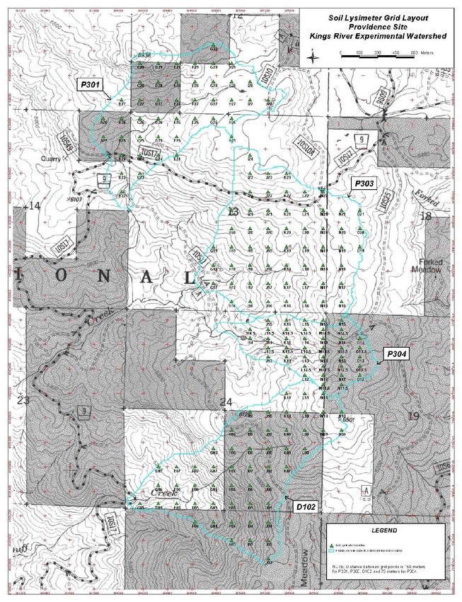
the Providence Site is made up of P301, P303, P304 often just upstream of the flumes, is being
717Figure 1. The Providence Site has four adjacent headwater watersheds (P301, P303, P304, and D102). The sampling grid is displayed against the landscape’s topography and is used to locate resin lysimeters, vegetation, fuel loading, and physical soil characteristic measurements. 718
used as a representative reach for stream invertebrate   We are using two types of lysimeters to characterize
and geomorphology measurements. These                    the nutrient fluxes and chemistry of shallow soil
measurements are taken annually. Permanent cross         water. The soil resin lysimeters are placed on a
sections are planned.                                    uniform grid spaced at one depth, 13 cm (5 in), to
                                                         measure the annual flux of nutrients through the
Natural deposition areas that existed directly           forest litter and soil layers above them. These
downstream of the flumes were transformed into           lysimeters provide information about soil nutrient
sediment ponds with 12 to 40 m3 (423 to 1,412 ft3)       flux. The Prenart vacuum lysimeter provides a
of storage space. We will be estimating the annual       continuous measurement of soil water chemistry at
load for each sediment basin, the relative percentage    one location from depths of 13 cm (5 in) and 26 cm
of organic versus inorganic material in that load, and   (10 in). The vacuum lysimeter data provides
the class size distribution within the inorganic         information on the variability of chemistry fluxes
fraction. Upland sediment fences will provide            during the wet season.
information on the proportion of sediment coming
from different upland sources such as roads and          Similar to soil water, we have two types of
other erosional areas. Some existing headcuts are        collection devices for atmospheric wet chemistry.
also being characterized and monitored.                  The snowmelt collectors give an estimate of the
                                                         variability in the precipitation chemistry during the
Soil physical properties profoundly influence the        wet season. The precipitation resin collectors give an
growth and distribution of vegetation through their      annual measure of the total input from rain and snow
effects on soil moisture regimes, aeration,              during the period they are in the field. Soil
temperature profiles, soil chemistry, and even the       lysimeters and precipitation collectors are placed in
accumulation of organic matter. These properties         the field at the same time; they are built according to
also influence erosion potential and the chemical        a design published by Susfolk and Johnson (2002).
composition of water that reaches streams. In
general, the dominant soil type by watershed             The major objective of our vegetation research is to
accounts for 50% or more of the area: Shaver and         examine the treatment effects on the vegetation
Gerle-Cagwin soils dominate the Providence Site,         within the watersheds. A secondary objective is to
and Cagwin soil dominates the Bull Site. Soil            determine effects on riparian vegetation in
sampling begins in 2003 and will be colocated with       particular, and characterize the transition from
vegetation and fuels loading measurements.               riparian to upland vegetation. Riparian transects are
                                                         placed perpendicular to the stream channel, starting
Within a watershed the chemical composition of           at the bankfull edge, and extending 20 m (66 ft) into
stream water serves as an integrator or expression of    the upland. Upland transects are placed at a subset of
the condition of the watershed both in the uplands       the grid points extending 20 m at a randomly chosen
and in the stream. Our goal is to measure water          azimuth. The number of riparian and upland
chemistry in several parts of the hydrologic cycle—      transects varies depending on the length of the
incoming precipitation, in shallow soil, and in the      channel and size of the watershed, respectively. At
stream. Currently KREW is measuring several              each transect herbaceous vegetation will be sampled
anions and cations; however, after one water year we     in 1x1 m quadrats, shrubby vegetation by line
will evaluate the need to continue this entire set of    intercept, and trees by a 10x20 m belt transect.
measurements. In general, water chemistry                Riparian and upland transects follow an identical
measurements are taken every two weeks although          protocol.
during or after a storm event samples may be more
frequent. Stream water samples are either collected      Ground, surface, understory, and overstory fuels will
as a grab sample by a person or by an Isco 6712          be measured at the same subset of grid points as
automated sampler that draws water from the stream       vegetation and soils. The protocol for these
and stores up to 24 un-refrigerated samples before       measurements has to be defined; however, methods
retrieval.                                               for the fuel components will closely match those of
                                                         the Sequoia National Park site of the Fire/Fire
                                                         Surrogate study.

                                                                                                            719
Figure 2. Ammonium and nitrate fluxes are
measured with resin lysimeters; replicate 5 is
high in both snowmelt and in both measured
soil horizons. Preliminary sampling at
Providence 303 revealed evidence that there are
“hotspots” of high nitrogen availability within a
fine spatial scale (meters).
Figure 3. Stream discharge hydrographs for Providence 303 and Duff 102 streams. The base flow of these
streams is between 0.05 and 0.1 cubic feet per second (cfs) and is controlled by groundwater sources. Duff has
the lowest average elevation, and the January storms came mostly as rain that caused brief, large discharges.
720Results and Conclusions California, Santa Barbara; California State
University, Fresno; and U.S. Geological Survey,
Preliminary sampling at Providence 303 revealed Sacramento. Funding is provided by the Joint Fire
evidence that there are “hotspots” of high nitrogen Sciences Program, the Pacific Southwest Research
availability within a fine spatial scale (Figure 2); Station, and the California Water Institute.
replicate 5 is high for both incoming precipitation
and both soil depths. The causes of this hotspot are References
not known at present, but the knowledge that such
hotspots occur is important in guiding sampling Hanson, C.L., D. Marks, and S.S. Van Vactor. 2001.
plans and in assessing potential sources of nitrogen Long-term climate database, Reynolds Creek
for the streams. Experimental Watershed, Idaho, United States.
Water Resources Research 37:289-2841.
One of the challenges of a landscape-scale
experiment is the similarity between study units, in Harrelson, C.C., C.L. Rawlins, and J.P. Potyondy.
this case, headwater watersheds. Stream discharge 1994. Stream channel reference sites: An illustrated
hydrographs for P303 and D102 during 2002 are guide to field technique. U.S. Department of
shown in Figure 3. While the discharges differ for Agriculture, Forest Service, General Technical
the two streams, the timing of peaks follows a Report RM-245. Fort Collins, CO.
similar pattern. For January, these hydrographs also
illustrate the difference between discharge patterns Karr, J.R. 1998. Rivers as sentinels: Using the
when one stream receives snow (P303) and another biology of rivers to guide landscape management. In
receives rain (D102). R.J. Naiman and R.E. Bilby, eds., River Ecology and
Management: Lessons from the Pacific Coastal
The intention of KREW is to be as holistic and Ecoregion, pp. 502-528. Springer-Verlag, New
integrated as possible with a focus on physical, York.
chemical, and biological variables of headwater
stream ecosystems and their associated watersheds. Naiman, R.J., and R.E. Bilby. 1998. River ecology
Much needed information for both basic and applied and management in the Pacific Coastal Ecoregion. In
science questions will be developed for the southern R.J. Naiman and R.E. Bilby, eds., River Ecology and
Sierra Nevada and sustainable forestry in general. Management: Lessions from the Pacific Coastal
Attention has been given to developing a suite of Ecoregion, pp. 1-10. Springer-Verlag, New York.
measurements that will facilitate modeling in several
disciplines: hydrology, meteorology and climate Susfolk, R.B., and D.W. Johnson. 2002. Ion
change, fire behavior and effects, soil erosion, and exchange resin based soil solution lysimeters and
biogeochemistry. An exciting opportunity will be to snowmelt solution collectors. Community Soil
calibrate and run models in the pretreatment phase Science Plant Analysis 33:1261-1275.
and then verify their predictive capabilities after the
management treatments. University of California, Davis. 1966. Summary of
the Sierra Nevada Ecosystem Project. Centers for
Acknowledgments Water and Wildland Resources.
The authors appreciate the efforts of our dedicated USDA Forest Service. 2001. Sierra Nevada forest
staff: Jeff Anderson, Chris Dolanc, Marie Lynch and plan amendment: Final environmental impact
Chad Johnson. Current collaborators are at statement. USDA Forest Service, Pacific Southwest
University of Nevada, Reno; University of Region, Vallejo, CA
721You can also read