Visual Impact Assessment in support of - AP56/2019
←
→
Page content transcription
If your browser does not render page correctly, please read the page content below
Visual Impact Assessment in support of
AP56/2019

Contents

Introduction .................................................................................................................................................. 3
Methodology................................................................................................................................................. 3
   Study area ................................................................................................................................................. 3
   Survey........................................................................................................................................................ 4
   Impact assessment.................................................................................................................................... 5
Baseline environment summary ................................................................................................................... 7
Impact Assessment ....................................................................................................................................... 8
   Introduction .............................................................................................................................................. 8
   Potential impacts ...................................................................................................................................... 8
   Impacts scoped out ................................................................................................................................... 9
   Parameters used for assessment ............................................................................................................ 10
   Measures adopted as part of the Project ............................................................................................... 10
   Impact Categorisation ............................................................................................................................. 10
       Impaired view- Scenic Route............................................................................................................... 14
       Impaired view- Local Residences ........................................................................................................ 14
   Cumulative Impact Assessment .............................................................................................................. 14
Conclusion ................................................................................................................................................... 15
References .................................................................................................................................................. 15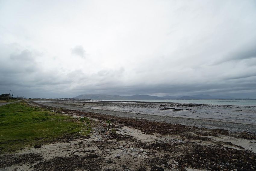
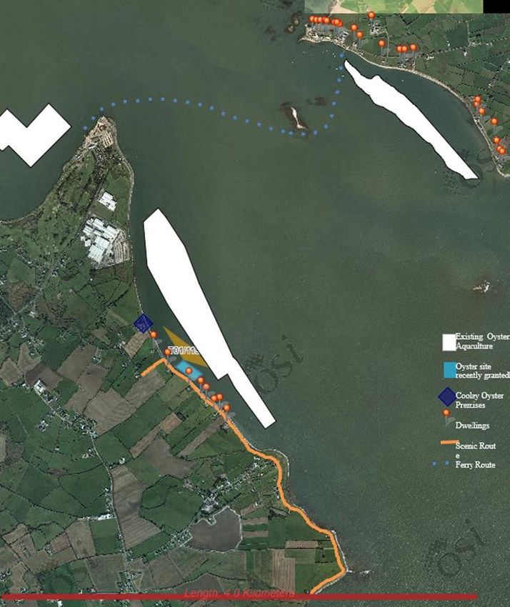
Introduction
I have carried out this visual assessment in line with the guidelines for Landscape and Visual Impact
Assessment of Marine Aquaculture (ERM, 2001).

Methodology
Study area
The study area for the assessment of impacts on landscape and visual amenity was calculated in
accordance with the Guidelines for the Assessment of the Landscape and Visual Impacts of Marine
Aquaculture Operations (DMNR & ERM, 2001). In line with the guidelines (DMNR & ERM, 2001), the
assessment is limited to a zone of visual influence (ZVI), 4 km distant from site T01/119A.

Local knowledge and a desk study were combined to identify sensitive receptors within 4km of the
proposed site. Data sources included: the Louth County Development Plan 2015-2021, National
Monuments Service and Ordnance Survey maps. Photos were taken of the proposed site from
surrounding roads. Graphics of the trestles were overlaid onto these images to give a visual representation
of the proposed activity.

Fig 1- Visual Envelope
The landscape and visual sensitivity of each receptor was then assessed as either high, moderate or low
based on its vulnerability and distance from the site (Table 1) The magnitude of the impact or change was
also assessed as high, moderate or low (Table 2).

Survey
Photographs were obtained from various positions that could be affected, visually, by the siting of the
proposed enclosures. During the survey a 2m high visibility yellow sleeve was deployed at the central
point and boundary corners of the site using GPS technology.

Photographs taken were overlaid and combined to produce a single image with precise plotting marks to
indicate site dimension. A CAD drawing of the enclosures was then introduced as a three-dimensional
model and scaled to the site, ensuring that relevant camera lens and camera orientation matched that of
the photograph. Once placed in position the plotting marks were erased and the image was adjusted to
compensate for atmospheric distortion. The final image is an accurate representation of what the
proposed site would look like if photographed.

Fig 2 – Survey locations and shot direction

Impact assessment
The degree of any impact on the landscape or visual amenity of the surrounding areas has been based
on a number of factors these include:

    1. Distance.
    2. Duration of viewing opportunities; and
    3. Amenity expectations.

Table 1 Sensitivity categorisation

 Sensitivity   Receptor      Definition/Description
 category
 Low           Landscape     Landscape that can accommodate aquaculture developments without
                             detriment to its character or features. No special landscape qualities or
                             values apply

               Visual        Viewers have limited viewing opportunities and/or low amenity
                             expectations, such as farmers, fishermen, aquaculture or other workers.
 Medium        Landscape     Landscape that can accommodate carefully sites, small scale aquaculture
                             development that respects existing landscape character and features.
                             May have some special qualities or values at a local level

               Visual        Viewers have moderate amenity expectations and/or short or
                             intermittent viewing opportunities, such as passing motorists, ferry users
                             and temporary residents
 High          Landscape     Landscape that is vulnerable to change as a result of aquaculture
                             development. Change may damage landscape feature(s) that are
                             important or distinctive in a regional or national context. Special qualities
                             or values at a regional or national scale apply.

               Visual        Viewers have high amenity expectations and/or prolonged viewing
                             opportunities, such as tourists, people involved in recreational pursuits
                             such as walking or sailing and local communities.

The magnitude of an effect is the degree of change caused by an event from baseline conditions. For
the purposes of this assessment, the magnitude of effect can be quantified using the criteria in Table
2.

Table 2 Magnitude categorisation

 Magnitude Receptor           Definition/Description
 category
 Low           Landscape      Limited or virtually imperceptible change in landscape elements and
                              features, giving rise to negligible change in landscape character and
                              qualities.

               Visual         Narrow visual envelope and/or few viewers affected.
                              Generally long-distance views and/or limited changes in view.
 Medium        Landscape      Moderate change in landscape elements and features, giving rise to a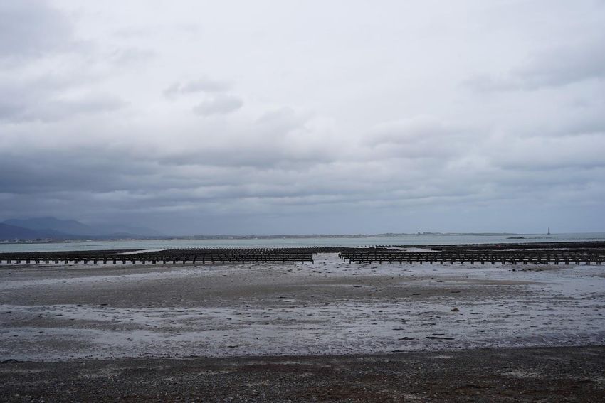
noticeable change in landscape character and qualities.

               Visual           Visual envelope of moderate size and/or moderate number of viewers
                                Affected. Some short or middle distance and/or moderate changes in view.
 High          Landscape        Extensive change in landscape elements and features, giving rise to a
                                marked change in landscape character and qualities.

               Visual           Extensive visual envelope and/or high number of viewers affected.
                                Short distance views and/or major changes in view.

The significance of an impact is determined by combining the site-specific sensitivity of the receptor and
magnitude of effect. This follows the approach in the National Guidelines (DMNR & ERM, 2001).

The significance ratings used in this assessment are presented in Table 3.

Table 3 Significance matrix

 Sensitivity of                                           Magnitude of change
 landscape or visual                    High                   Medium                              Low
 receptor
 High                         Very Substantial           Substantial                  Moderate
 Medium                       Substantial                Moderate                     Slight
 Low                          Moderate                   Slight                       Negligible

According to the Guidelines for the Assessment of the Landscape and Visual Impacts of Marine
Aquaculture Operations (DMNR & ERM, 2001), where impacts are identified as of “Substantial or Very
Substantial” significance, these are considered “Unacceptable” whilst potential impacts assessed as of
Moderate significance or lower (Slight and Negligible) are considered “Acceptable”, subject to satisfactory
conditions on detailed siting layout, design and environmental management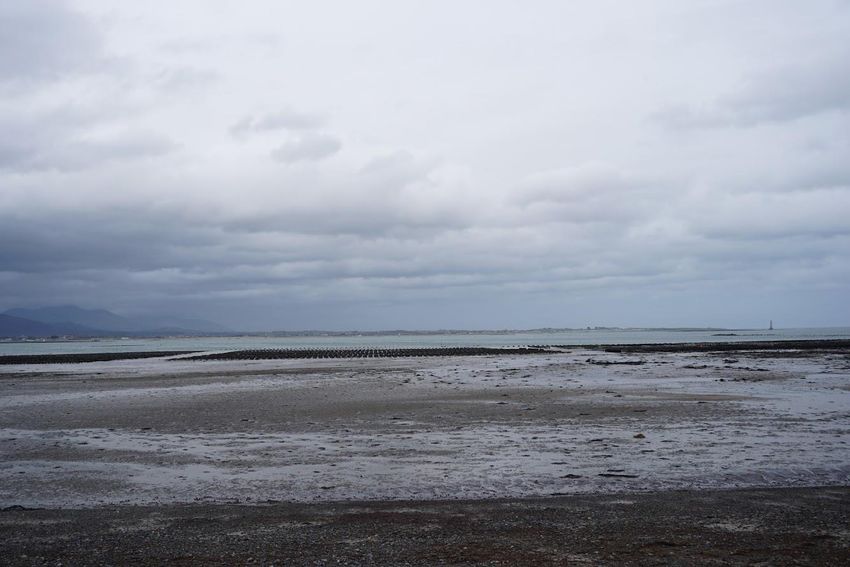
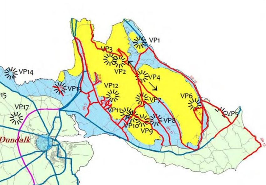
Baseline environment summary
In the Louth County Development Plan 2015-2021, the roadway adjacent to site T01/119A is designated
as a scenic route (SR 15). These views and prospects are reflective of Louth’s unique scenic quality and
are notable for their natural scenery and striking landscapes. Developments should not interfere with or
adversely affect these scenic routes.

Aquaculture sites are already visible from this route and were visible at the time of designation, one site
closer to the scenic route applied for by another oyster farmer has recently been subject to a positive
determination. Louth co. co. did not object to any oyster licence applications or renewals in this area.

The shore at this location is used by local walkers, it is not used as a swimming location.

Fig 3 - Viewpoints and scenic routes (Louth County Development Plan 2015-2021)

The Carlingford Lough Ferry route passes to the north of the site

There are approximately 35 properties within the visual envelope that are within 4km of the application
area will potentially have views of the site.
Impact Assessment
Introduction
This section presents an assessment of the potential impacts identified arising from the Project on
landscape and visual amenity.

Potential impacts
In the case of marine aquaculture, the key impacts to be considered are (DMNR & ERM, 2001):

    •   Effects on the intrinsic character and quality of remote unspoilt landscapes
    •   Physical change and damage to landscape elements for example through the provision of new
        slipways or access tracks; and
    •   Effects on the visual amenity of residents, tourists and other water users – which in turn may
        adversely affect the livelihoods of those dependent on tourism.

Impact prediction was undertaken in line with Departmental Guidelines (DMNR & ERM, 2001). The
guidance document states that impact prediction involves the systematic identification and description of
effects including:

    •   Direct effects on landscape features, such as the removal of vegetation or other features;
    •   Indirect effects on landscape character and qualities from the introduction of the Project; and
    •   The effect of a single farm on the character of the seascape but cumulative impacts must be
        considered for one or more farms.

Effects on visual amenity enjoyed by people as a result of changes in landscape features, character and
qualities must be considered. These depend on factors such as the nature of the change, the degree of
intrusion in the field of view, the numbers and type of viewers affected, the viewing distance and
cumulative impacts. In addition, the landscape appraisal recommends that particular attention should be
given to the preservation of the character and distinctiveness of these coastal areas as viewed from scenic
routes and the environs of archaeological and historic sites (CAAS, 2008).

Potential impacts identified for landscape and visual amenity associated with the operation phase of the
Project, demonstrating the source – pathway – receptor route to potential impacts are summarised in
Table 4.
Table 4 - Potential impacts identified
Potential Impact Source Pathway Receptor
Short distance views 2km
Impaired view Presence of the Project Long distance view 2.5-3.5 Residents on the NI side of
km the Lough
Impaired view Presence of the Project Long distance view >3km Cranfield Beach NI
Impaired view Presence of the project Long distance view >3km Greencastle Road – NI
Impaired view Presence of the Project Long distance view >3km Fair Rd – NI
No archaeological and historic sites are in the vicinity of the project
Impacts scoped out
Those effects and impacts that have been scoped out are described in this section and justification for
this decision given (Table 5)
Table 5 - Justification for impacts scoped out
Potential impact Justification for scoping out
Visual
Impaired view by ferry passengers and The structures on the proposed site will be screened by existing
passengers of leisure sailing vessels trestles on licenced area seaward of the proposed site
Impaired view from residents, The structures on the proposed site will be screened by existing
roadways, beaches and roads in NI trestles on licenced area seaward of the proposed site
Impaired view from residential Local topography, screening by existing oyster farming structures
properties in IE outside the immediate and/or distance eliminates any viewing opportunities
vicinity of the projectParameters used for assessment
The key parameters used for assessment of the potential impacts identified on landscape and visual
amenity as a result of the Project are described in Table .
Table 6 Parameters used for assessment
Potential impact Assessment parameters Justification
Visual amenity from this location
Location of structures - survey
Impaired view – SR15 will be affected by the introduction
conducted to define viewpoint
of structures in the site area
Impaired view – Residential Location of structures - survey Visual amenity from this location
properties conducted to define viewpoint will be affected by the introduction
of structures in the site area
Measures adopted as part of the Project
The assessment within this chapter takes into account mitigation measures that are incorporated into
the design of structures and their placement on the shore. These are part of the design process and
other measures that are considered standard practice.
Measures adopted as part of the Project relevant to landscape and visual amenity, are in line with
project design criteria listed in National Guidance (DMNR, 2001) as set out below:
• All structures/trestles and bags on the site will be approximately the same size
• Trestles are aligned parallel to the shore in the same configuration as currently permitted
structures on the shore at Ballagan
• Trestles are low-profile structures.
• As the site sits behind the exiting culture area, no additional navigational beacons will be
required
• The substate in the area is dark and thus the structures will not be contrasting against a bright
substrate.
• On the east coast of Ireland, the majority of tides which will expose this site to viewers occur
during the hours of darkness
Impact Categorisation
The impacts of placing structures on this site have been assessed on landscape and visual amenity in the
study area. A description of the potential changes on landscape and visual amenity receptors caused by
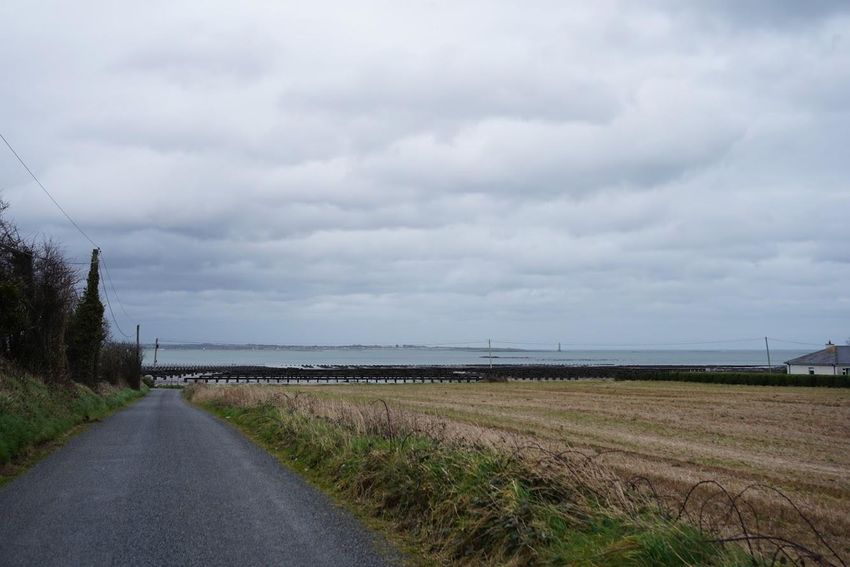
each identified impact is given below.Fig 4 – Existing view from crest of hill on scenic route Fig 5 – Projected view from crest of hill on scenic route
Fig 6 – Existing view from slipway

Fig 7 – Projected view from slipway
Fig 7 – Existing view from corner

Fig 7 – Projected view from corner
Impaired view- Scenic Route
The Sensitivity of tourists to landscape and visual amenity impacts associated with the placing of
structures on this site is Medium owing to the intermittent nature of viewing opportunities and the
presence of oyster farming structures already in this area. The Magnitude of change is Medium due to the
size of the visual envelope (Large), the fact that the site will be covered by seawater most of the time and
the presence of existing oyster structures in this area. This gives an overall risk Significance of Moderate
for the Ferry passengers and is therefore Acceptable subject to standard licence conditions on site layout,
design and environmental management.

Impaired view- Local Residences
The Sensitivity of local residents to landscape and visual amenity impacts associated with the placing of
structures on this site is Medium owing to the intermittent nature of viewing opportunities and the
existing presence of oyster farming structures in this area. The Magnitude of change is Medium due to
the size of the visual envelope (Large), the fact that the site will be covered by seawater most of the time
and the presence of existing oyster structures in this area. This gives an overall risk Significance of
Moderate for the Ferry passengers and is therefore Acceptable subject to standard licence conditions on
site layout, design and environmental management.

Cumulative Impact Assessment
The following section describes the potential for the Project to result in cumulative impacts with other
projects and proposed developments on landscape and visual amenity.

As described above, impacts on landscape and visual amenity as a result of the Project will be confined to
a 4 km Zone of Visual Amenity. There are existing oyster aquaculture sites within this zone. But the current
proposal is not considered to be a significant addition in terms of visual or landscape intrusion but rather
a small addition to an existing culture block.

Visual amenity has never been raised as a concern in this area by the local council or residents as a result
of oyster culture activities

Cumulatively Sensitivity is Low and the Magnitude of change is Low, therefore the cumulative impacts will
be of Negligible Significance and therefore Acceptable.
Conclusion

The impact assessment in respect of landscape and visual amenity did not identify potential for significant
impacts to occur as a result of the Project either alone or cumulatively with other projects. A summary of
the conclusions of the impact assessment is provided in Table 7.

Table 7 Conclusions of EIS in respect of landscape and visual amenity

 Potential impact      Receptor     Sensitivity    Magnitude        Significance   Conclusion
                                                                    Rating
 Operation
 Impaired view –       Landscape    Medium         Medium           Moderate       Acceptable
 SR15                  Visual       Medium         Medium           Moderate       Acceptable
 Impaired view –       Landscape    Medium         Medium           Moderate       Acceptable
 SR15                  Visual       Medium         Medium           Moderate       Acceptable
 Cumulative Impacts
 Cumulative with       Landscape    Low            Low              Negligible     Acceptable
 other oyster          Visual       Low            Low              Negligible     Acceptable
 aquaculture in the
 Zone of visual
 influence

References
CAAS Ltd (2008) Landscape Appraisal of County Mayo.

DMNR and ERM (2001) Guidelines for the Assessment of the Landscape and Visual Impacts of Marine
Aquaculture Operations, Department of Marine & Natural Resources.

http://webgis.archaeology.ie/historicenvironment/

https://dahg.maps.arcgis.com/apps/webappviewer/index.html?id=89e50518e5f4437abfa6284ff39fd640
You can also read