TEMA JOURNAL OF - JOURNAL OF LAND USE, MOBILITY ...
←
→
Page content transcription
If your browser does not render page correctly, please read the page content below
TeMA
The Times They Are a-Changin' and cities have to face challenges which may
not be further postponed. The three issues of the 13th volume will collect
                                                                                   Journal of
                                                                                   Land Use, Mobility and Environment
                                                                                   TeMA is the Journal of Land Use, Mobility and Environment and offers
                                                                                   papers with a unified approach to planning, mobility and environmental su-
articles concerning the challenges that cities are going to face in the            stainability. With ANVUR resolution of April 2020, TeMA journal and the arti-
immediate future, providing readings and interpretations of these phenomena        cles published from 2016 are included in the A category of scientific jour-
and, mostly, methods, tools, technics and innovative practices (Climate proof      nals. From 2015, the articles published on TeMA are included in the Core
cities, Zero consumption cities, Car Free cities, ...) oriented to gain and keep   Collection of Web of Science. It is included in Sparc Europe Seal of Open
a new equilibrium between cities and new external agents.
                                                                                   Access Journals, and the Directory of Open Access Journals.

THE CITY CHALLENGES AND EXTERNALAGENTS.
METHODS, TOOLS AND BEST PRACTICES

Vol.13 n.1 April 2020                                                                                            print ISSN 1970-9889 e-ISSN 1970-9870
                                                                                                                           University of Naples Federico II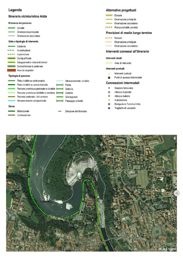
TeMA                                                                     Journal of
                                                                         Land Use, Mobility and Environment

THE CITY CHALLENGES AND EXTERNAL AGENTS.
METHODS, TOOLS AND BEST PRACTICES
1 (2020)

Published by
Laboratory of Land Use Mobility and Environment
DICEA - Department of Civil, Architectural and Environmental Engineering
University of Naples "Federico II"

TeMA is realized by CAB - Center for Libraries at “Federico II” University of Naples using Open Journal System

Editor-in-chief: Rocco Papa
print ISSN 1970-9889 | on line ISSN 1970-9870
Licence: Cancelleria del Tribunale di Napoli, n° 6 of 29/01/2008

Editorial correspondence
Laboratory of Land Use Mobility and Environment
DICEA - Department of Civil, Architectural and Environmental Engineering
University of Naples "Federico II"
Piazzale Tecchio, 80
80125 Naples
web: www.tema.unina.it
e-mail: redazione.tema@unina.it

The cover image is a photo of a street in the city of Naples during the COVID-19 pandemic quarantine (April 2020)

TeMA Journal of Land Use Mobility and Environment 1 (2020)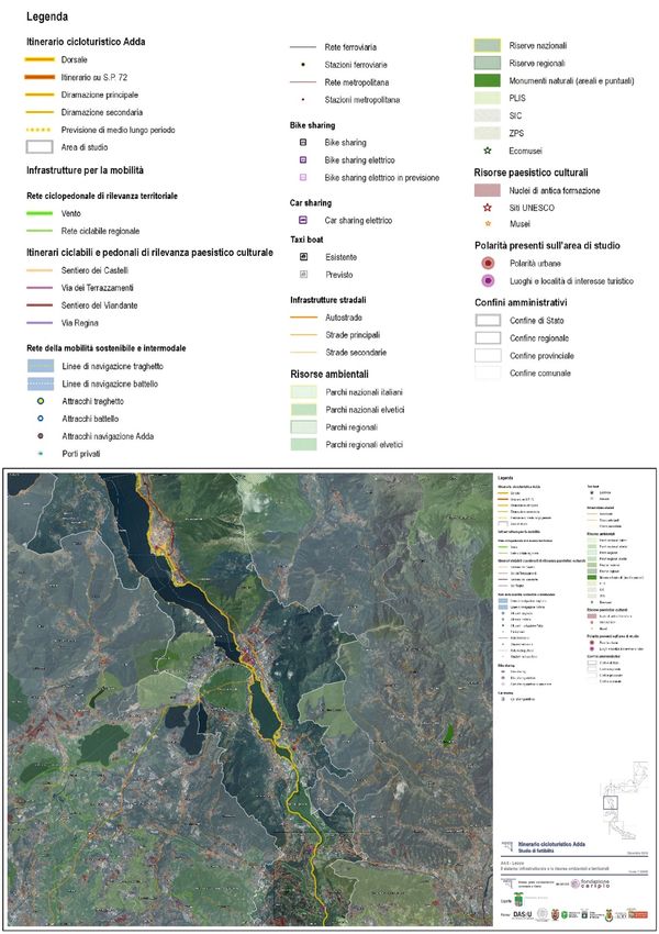
TeMA. Journal of Land Use, Mobility and Environment offers researches, applications and contributions with a unified approach to planning and
mobility and publishes original inter-disciplinary papers on the interaction of transport, land use and environment. Domains include: engineering,
planning, modeling, behavior, economics, geography, regional science, sociology, architecture and design, network science and complex
systems.
With ANVUR resolution of April 2020, TeMA Journal and the articles published from 2016 are included in A category of scientific journals. From
2015, the articles published on TeMA are included in the Core Collection of Web of Science. TeMA Journal has also received the Sparc Europe
Seal for Open Access Journals released by Scholarly Publishing and Academic Resources Coalition (SPARC Europe) and the Directory of Open
Access Journals (DOAJ). TeMA is published under a Creative Commons Attribution 3.0 License and is blind peer reviewed at least by two
referees selected among high-profile scientists. TeMA has been published since 2007 and is indexed in the main bibliographical databases and
it is present in the catalogues of hundreds of academic and research libraries worldwide.

E DITOR IN-CHIEF
Rocco Papa, University of Naples Federico II, Italy

E DITORIAL A DVISORY B OARD
Mir Ali, University of Illinois, USA
Luca Bertolini, University of Amsterdam, Netherlands
Luuk Boelens, Ghent University, Belgium
Dino Borri, Polytechnic University of Bari, Italy
Enrique Calderon, Polytechnic University of Madrid, Spain
Roberto Camagni, Polytechnic University of Milan, Italy
Derrick De Kerckhove, University of Toronto, Canada
Mark Deakin, Edinburgh Napier University, Scotland
Aharon Kellerman, University of Haifa, Israel
Nicos Komninos, Aristotle University of Thessaloniki, Greece
David Matthew Levinson, University of Minnesota, USA
Paolo Malanima, Magna Græcia University of Catanzaro, Italy
Agostino Nuzzolo, Tor Vergata University of Rome, Italy
Rocco Papa, University of Naples Federico II, Italy
Serge Salat, Urban Morphology and Complex Systems Institute, France
Mattheos Santamouris, National Kapodistrian University of Athens, Greece
Ali Soltani, Shiraz University, Iran

A SSOCIATE E DITORS
Rosaria Battarra, National Research Council, Institute of Mediterranean studies, Italy
Gerardo Carpentieri, University of Naples Federico II, Italy
Luigi dell'Olio, University of Cantabria, Spain
Isidoro Fasolino, University of Salerno,Italy
Romano Fistola, University of Sannio, Italy
Carmela Gargiulo, University of Naples Federico II, Italy
Thomas Hartmann, Utrecht University, Netherlands
Markus Hesse, University of Luxemburg, Luxemburg
Seda Kundak, Technical University of Istanbul, Turkey
Rosa Anna La Rocca, University of Naples Federico II, Italy
Houshmand Ebrahimpour Masoumi, Technical University of Berlin, Germany
Giuseppe Mazzeo, National Research Council, Institute of Mediterranean studies, Italy
Nicola Morelli, Aalborg University, Denmark
Enrica Papa, University of Westminster, United Kingdom
Dorina Pojani, University of Queensland, Australia
Floriana Zucaro, University of Naples Federico II, Italy

E DITORIAL S TAFF
Gennaro Angiello, Ph.D. at University of Naples Federico II, Italy
Stefano Franco, Ph.D. student at Luiss University Rome, Italy
Federica Gaglione, Ph.D. student at University of Naples Federico II, Italy
Carmen Guida, Ph.D. student at University of Naples Federico II, Italy
Rosa Morosini, Ph.D. student at University of Naples Federico II, Italy
Andrea Tulisi, Ph.D. at Second University of Naples, Italy

TeMA Journal of Land Use Mobility and Environment 1 (2020)
TeMATHE CITY CHALLENGES AND EXTERNAL AGENTS.
                                                                     Journal of
                                                                     Land Use, Mobility and Environment

        METHODS, TOOLS AND BEST PRACTICES

        1 (2020)

        Contents
5

        3          EDITORIAL PREFACE
                   Rocco Papa

                   FOCUS

        5          Accessibility Analysis for Healthcare Centers using Gravity Model and Geospatial
                   Techniques
                   Shanmathi Rekha Raju, Shayesta Wajid, Nisha Radhakrishnan, Samson Mathew

                   LAND USE, MOBILITY AND ENVIRONMENT

        21         Analysis of commuting in Attica
                   Maria Stefanouli, Serafeim Polyzos

        41         Evaluating metropolises grow and their impact on the around villages using
                   Object-Oriented Images
                   Bahram Imani, Farshid Sattari, Jafar Jafarzadeh

        55         How Italian metropolitan cities are dealing with the issue of climate change?
                   Walter Molinaro

        81         “Itinerario Cicloturistico Adda”. A route between a variety of territories,
                   landscapes and identities
                   Fulvia Pinto, Andrea Fossati

    TeMA Journal of Land Use Mobility and Environment 1 (2020)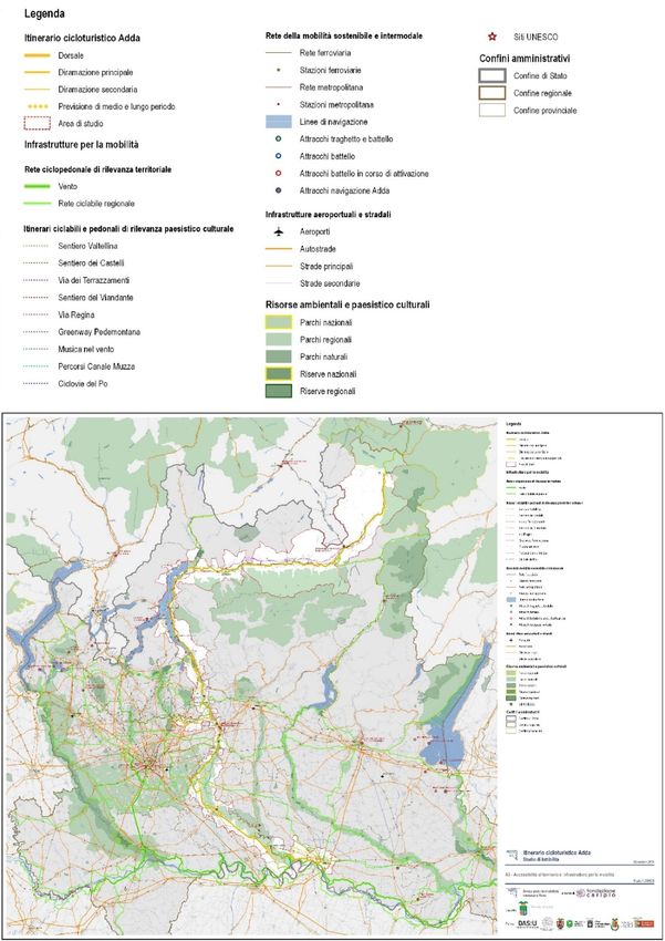
99         REVIEW PAGES
               Gennaro Angiello, Federica Gaglione, Carmen Guida, Rosa Morosini, Andrea Tulisi

TeMA Journal of Land Use Mobility and Environment 1 (2020)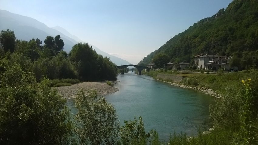
TeMA                                                        Journal of
                                                            Land Use, Mobility and Environment

A
TeMA 1 (2020) 81-97
print ISSN 1970-9889, e-ISSN 1970-9870
DOI: 10.6092/1970-9870/6608
Received 13th January 2020, Accepted 25th March 2020, Available online 30th April 2020
Licensed under the Creative Commons Attribution – Non Commercial License 3.0
www.tema.unina.it

“Itinerario Cicloturistico Adda”. A route between a
variety of territories, landscapes and identities

Fulvia Pinto*, Andrea Fossati
Department of Architecture and Urban Studies (DAStU)
Politecnico di Milano, Milan, Italy
e-mail: fulvia.pinto@polimi.it; andrea.fossati@polimi.it
ORCID: https://orcid.org/0000-0002-2179-1716
* Corresponding author

Abstract
Cycle tourism is a popular recreational activity in Europe where the distances between the places are
relatively short and the itineraries are full of attractions and points of interest. Tourism by bicycle is
expanding both at European and Italian level. At the basis of this phenomenon there is also an attitude of
awareness of the risks for the environment and a progressive evolution of critical awareness towards more
conscious consumption. Cycling in the suburban area, in particular for reasons related to leisure, sport and
tourism, is usually linked to medium - long distance itineraries, put into a system with short distances, often
also used by residents of the territories concerned. The cycling routes run along areas of great tourist
attraction and in which there are multiple opportunities to visit historic cities, UNESCO sites or places with
environmental value. The cycling route Adda project starts from the analysis and enhancement of the
environment and the existing cycle network. The main objective of the research concerns the construction
of a methodological tool to support the governance of the territory. The analysis and research developed
through the comparison with other experiences with a focus on intermodal dimension of mobility. The main
result of the project is that it provided a homogeneous and systematic framework of the efforts needed for
the completion of the cycle path, articulated according to a priority logic. A framework in which, in relation
to the specificities of each area, are indicated some of the design solutions, in the knowledge that a project
of this importance should be implemented in an incremental manner, acting in multiple directions, through
coordination of action and governance.

Keywords
Sustainable and intermodal mobility; Cycling route; landscape; multi-scale project.

How to cite item in APA format
Pinto, F., & Fossati, A. (2020). “Itinerario Cicloturistico Adda”. A route between a variety of territories,
landscapes and identities. Tema. Journal of Land Use, Mobility and Environment, 13 (1), 81-97.
http://dx.doi.org/10.6092/1970-9870/6608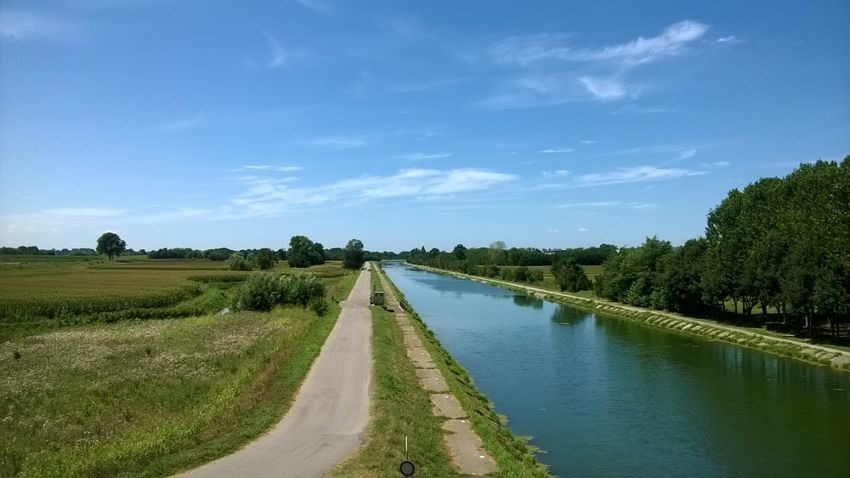
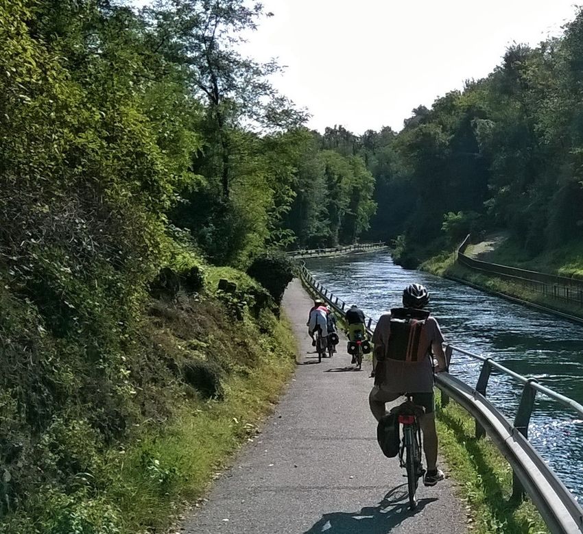
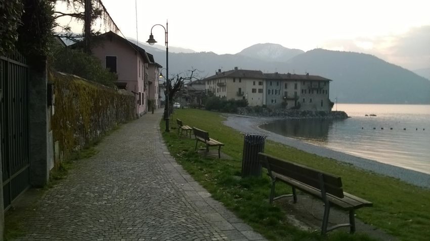
Pinto, F., & Fossati, A. – ”Itinerario Cicloturistico Adda”. A route between a variety of territories, landscapes and identities

1. The cycle-tourist itineraries for cultural dissemination
Promoting bicycle use is a fundamental part of the strategy of managing public transport and land use
development. There is a strong connection between cycling and landscape, as its slow speed affords us the
opportunity to enjoy the landscape.
The cycle paths form part of the concept of enhancement and awareness of places. Quality interventions are
needed that innervate the area, and, in this logic, the cycle route is intended as a framework of the territory.
Cycling mobility connects territories, uses and cultures, but the bicycle becomes a real alternative only if it is
well integrated with other transport systems.
Tourism, which involves the use of bicycles to explore the area to visited (cycling tourism), is booming both
at European and Italian level (Fig. 1).

Fig. 1 The “Itinerario Cicloturistico Adda” along the "Naviglio di Paderno"

Underpinning this phenomenon there is also a renewed attitude of awareness not to harm the environment
and a progressive evolution of conscience towards a more sustainable consumption.
Cycling outside urban areas, in particular for leisure, sport and tourism, is usually linked to medium-long
distance itineraries, consisting of short distances, often used also by residents of the interested territories. The
cycle touring itineraries “Vento” along paths with great tourist attractiveness and present ample opportunities
to visit historic cities, UNESCO sites or sites of environmental value.

82 - TeMA Journal of Land Use Mobility and Environment 1 (2020)
Pinto, F., & Fossati, A. – ”Itinerario Cicloturistico Adda”. A route between a variety of territories, landscapes and identities

Cycling tourism appears to be a widespread and growing recreational activity in the European context, a
context in which the distances between places appear to be relatively short and the itineraries are attractive
and through points of interest. It is therefore an excellent cultural dissemination vector capable of transmitting,
through the identity of its routes, the history and values of a place and a territory. If analyzed and promoted,
cycle tourism is a concrete opportunity for qualitative conversion of the entire local tourism system and a way
of sustainably developing the territories.
The approach to building a sustainable tourism mobility network involves the combined use and enhancement
of existing infrastructures. The improvement of internal mobility must be achieved through the integration of
multiple travel modes and means of transport, public or collective.
Intermodality must allow tourists to visit the area in a slow and non-polluting way, relying on the combination
of public or collective means to reach the places to visit.
In Europe the idea of a supra-national cycling network (Eurovelo) that can support new forms of green tourism
is taking shape.
At national level, the law 2/2018 has the dual objective of promoting the use of bicycles both as a means of
daily transportation and for tourism and recreational activities, in order to:
-     improve the efficiency, safety and sustainability of urban mobility, against traffic and pollution;
-     increase and develop tourism, protecting the natural and environmental heritage and enhancing the
      territory and cultural heritage.
The focus of the measure is the “general plan of cycling”. The plan identifies the measures to be taken to
promote the use of bicycles in urban and metropolitan areas on regional, national and European level routes.
The Regions will have to prepare and approve the “regional cycle mobility plan” every three years.
The Lombard territory contains some important back crossing axes, identified by the Regional Cycling Mobility
Plan, on which it is possible to create a cycle network model of tourist and territorial relevance.
The Adda Cycle-tourism itinerary allows the identification of a system of strategic routes for the connection
and accessibility of important natural, environmental and landscape features that characterize and distinguish
the territory.

2. Features and aim of the project
The “Itinerario Cicloturistico Adda” is a cycle route that runs from the Alps to the Po for 310 km, along the
Adda and Lake Como from Bormio to Cremona and crosses six provinces, the Metropolitan City of Milan and
105 municipalities. The main bike path is supplemented by four main branches and a series of secondary
connections that connect the inhabited centers, services and environmental and landscape-cultural resources.
This network of connections also guarantees access to the public transport network and the intermodal mobility
system. Considering the main and secondary branches, the cycling network planned by the project has a total
length of 401 km (Fig. 2).
The feasibility study of the itinerary was developed as part of the "BREZZA: cycling trails connected to the
VENTO"1 call for proposals, promoted and co-financed by the Cariplo Foundation in order to create a network
of cycle lanes between the VENTO cycle route and the territory.
The study was prepared by the local authorities directly involved in the itinerary and by the Politecnico di
Milano. More precisely from the province of Lecco (leader), from the Metropolitan City of Milan, from the
provinces of Sondrio, Monza and Brianza, Lodi and Cremona and from the Departments of Architecture and
Urban Studies (DAStU) and of Civil and Environmental Engineering (DICA) of the Politecnico di Milano.2

1
      VENTO is a cycle-touring route project that extends for 679 km, along the Po, from Venice to Turin.
2
      The itinerary also, even if for a short stretch, crosses the province of Como and more precisely the municipality of
      Gera Lario, located in the Alto Lario territory.

83 - TeMA Journal of Land Use Mobility and Environment 1 (2020)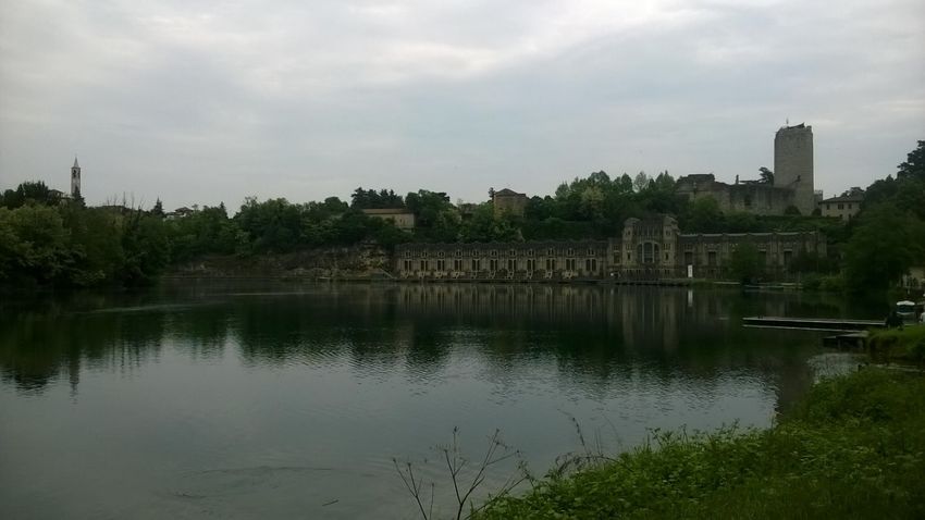
Pinto, F., & Fossati, A. – ”Itinerario Cicloturistico Adda”. A route between a variety of territories, landscapes and identities

Fig. 2 Accessibility to the territory and mobility infrastructures. The map represents the Adda Cycling Itinerary that stretches
from Bormio to Cremona

The cycle touring itinerary covers a vast area, characterized by a multitude of landscapes, rich in pre-existing
features that reflect different cultures and identities that have become stratified throughout history and that
today represent important tourist attractions.

84 - TeMA Journal of Land Use Mobility and Environment 1 (2020)
Pinto, F., & Fossati, A. – ”Itinerario Cicloturistico Adda”. A route between a variety of territories, landscapes and identities

A large part of the routes of the itinerary already exist, therefore the purpose of the project is to redevelop
and complete the existing cycle network and enhance the use of environmental and cultural landscape
resources, according to a priority logic aimed at solving the main discontinuities present along the way and
implementing the projects already present in the area.
Following these principles, the main objectives of the feasibility study are the following:
-     the construction of a reference framework for the completion of the cycle network along the Adda and
      the Lario, in order to support and promote territorial governance and participatory processes;
-     the development of the strengthening of the territory, through the enhancement and networking of
      historical, cultural, landscape environmental resources and of tourist and recreational facilities;
-     the promotion of sustainable and multimodal mobility aimed at enhancing the role of the bicycle in
      support of local mobility and tourist use of the territory;
-     the definition of a sustainable project in terms of both the implementation of the interventions and the
      management of the cycle route.

3. Contents and methodology

3.1 The structure of the study
The feasibility study was structured in a systematic way and in a multi-scale dimension, in order to offer a
reference framework for the priorities of intervention on the regional scale and for the works at local level.
Particular attention was paid to the ways of representing and describing the cycle network, the infrastructure
system and the environmental and territorial resources. The aim is to offer a unified and simultaneous reading
of the Adda cycle tourism route and of the multiple interrelations that are generated with the area, at different
territorial scales.
The work was structured in two parts. The first part is dedicated to the general description of the study, the
second to an analytical description of the six project areas, identified in relation to the administrative
boundaries of the territorial bodies involved in the project, to the characteristics of the territorial context, of
the cycle network and to the intervention strategies. Starting from the north, the following territorial areas
have been defined: Valtellina, Lake Como and Brianza Lecchese, Monza and Brianza, Metropolitan City of Milan
and Alto Lodigiano, Lodi, Cremona and Basso Lodigiano.
In relation to the specific territorial characteristics, some areas have been divided into sub-areas. The
articulation by areas offers each territorial entity a specific instrument for the implementation and governance
of the planned interventions. The work was structured in a homogeneous way in order to allow a simultaneous
and transversal reading of the different territorial areas and the possible aggregated and disaggregated
reading and of the various analysis and project data, in relation to specific needs.

3.2 The survey and the design of the cycle network
The cycling routes have been identified starting from the analysis of the existing network and by the relative
planning, at the territorial and local scale. In relation to what emerged from these analyses, in the parts of
the route where critical issues or solutions have been identified, project alternatives have been defined, as
regards to what is contained in the programmed framework.
The comparison between the design choices and the programmed framework was carried out analytically, on
the territorial and municipal scale and is represented and described in the cartography and in the analysis and
project sheets, drawn up for each territorial area affected by the cycling itinerary.
The functional technical characteristics of the routes have been described and represented with the aim of
providing an effective operational tool for the implementation of the interventions. To this end, a methodology

85 - TeMA Journal of Land Use Mobility and Environment 1 (2020)
Pinto, F., & Fossati, A. – ”Itinerario Cicloturistico Adda”. A route between a variety of territories, landscapes and identities
has been defined that allows a simultaneous reading of the main characteristics of the tracks. The analysis
and classification of the routes was determined in relation to the following criteria:
a) technical and functional categories of the cycle network defined by the Ministerial Decree 557/1999
Regulation for the definition of the technical characteristics of cycle paths, in order to verify the
compliance with the regulations of the existing routes and the feasibility of the hypothesized
interventions, as well as the level of safety and usability of these routes, in relation to the different types
of users;
b) route hierarchy, with the aim of identifying the priorities for action, in relation to the relevance of the
routes and the reference territorial context;
c) current status of the routes and type of planned interventions (existing, planned, redevelopment,
adjustments and minor interventions, acquisition of areas) in order to give an overview of the planned
interventions and their relevance and guide the design choices.
In relation to this classification, the pedestrian and cycle paths have been divided into sections that have
homogeneous characteristics. A code has been assigned to each section, showing the route hierarchy, the
province, the municipality and the progressive number of sections in the municipality.
In the papers relating to the "Representation and description of the cycle network and of the proposed
interventions" prepared for each territorial area, a graphic representation of the paths has been prepared
which allows a simultaneous reading of the previously described characteristics. There are also tables where,
for each section, the characteristics of the tracks and the planned interventions are described (including the
indications of any alternative projects) and the costs for the works to be carried out and for any areas to be
acquired. This system allows for an analytical and systematic overview of the cycling network (bike path, main
and secondary branch) and of the planned interventions, where the different information can be aggregated
and broken down according to specific needs (Figure 3). A summary with the indication of the intervention
priorities is then reported in the technical reports of the feasibility study.
3.3 The representation of the territory and of the attraction poles
The study of the area affected by the cycling path was carried out with a dual purpose. On the one hand, the
environmental, settlement and morphological conditions of the territory were analyzed to identify the most
appropriate design choices for the completion and enhancement of the cycle network, on the other hand all
the services, equipment and environmental resources were mapped and cultural landscapes that act as
attractors for the use of cycling in the area (Figure 4).
The methodology used for the representation is not only aimed at providing a systematic picture of territorial
services and resources, organized by categories and sub-categories, but also to bring out the multiple
synergies that are created between these elements. This has been possible thanks to a graphic representation
technique that allows an intuitive reading of the territory and at the same time allows multiple information to
be superimposed in the same thematic tables.
The information collected in the documents “Representation and description of the cycle network and of the
territorial context” drawn up for each territorial area, are supported by quantitative data, which, thanks to the
use of GIS, can be read and interpreted in various ways, in relation to the specific needs and the different
projects identified by the feasibility study.
The data collected and the indicators that supported the analysis of the territory and the design choices were
divided into thematic areas, in order to provide useful elements for the completion of the cycle network
involved in the project and concerned in particular:
- the state of conservation and the technical-functional characteristics of the existing and planned cycle
network;
- the presence of equipment to support the cycle-tourism use of the area, both traditional and electric;
86 - TeMA Journal of Land Use Mobility and Environment 1 (2020)Pinto, F., & Fossati, A. – ”Itinerario Cicloturistico Adda”. A route between a variety of territories, landscapes and identities Fig. 3 Representation and description of the cycle network and of the proposed interventions. The image represents an example of the mapping of the existing cycling network and the related redevelopment and completion interventions, relating to the territory of Trezzo d'Adda. The codes shown in the map, in scale 1: 5000, constitute a reference for the tables dedicated to the description of each individual section of the existing and project cycling network, shown after each map. 87 - TeMA Journal of Land Use Mobility and Environment 1 (2020)
Pinto, F., & Fossati, A. – ”Itinerario Cicloturistico Adda”. A route between a variety of territories, landscapes and identities

Fig. 4 The infrastructure system and environmental and territorial resources. The map shows, in scale 1:50000, the
infrastructural system and the environmental and territorial resources of the Lower Lario and Brianza. An analytical and
systematic representation of all the services and environmental resources, present along the cycling route, is represented,
in scale of 1: 10000, in the elaborates “Representation and description of the cycle network and of the territorial context”.

88 - TeMA Journal of Land Use Mobility and Environment 1 (2020)
Pinto, F., & Fossati, A. – ”Itinerario Cicloturistico Adda”. A route between a variety of territories, landscapes and identities

-     the infrastructures that allow accessibility to the territory and in particular the intermodality between
      train, bike and navigation;
-     environmental and landscape-cultural resources;

-     the presence of services and equipment for the resident population;
-     tourist services and equipment;

-     the provision of sports and recreational play equipment.
The information and data that emerged from the analysis of the territory which is particularly vast and complex,
extending from the Alps to the Po, were assessed and weighed in a diversified way in relation to the
characteristics of each specific territorial area, the planning guidelines and the interaction with the provinces
and with other interested actors.
The picture that emerged made it possible to highlight the various possible uses of the existing and planned
cycle network by tourists, city users and the resident population.
The aim is to create synergies between the different uses of the cycle network, coordinate design choices on
a local and territorial scale and optimize the use of available resources.
Recreational tourism is the key element of the project, but particular attention was also paid to the movements
of the permanent population (home-work trips, home-school trips , connections with services, ...), in order to
encourage the use of the network cycle path and, consequently, to increase investments on priority
interventions, both for the completion of the cycling route and its offshoots, and for urban mobility.
The needs of cycle-tourism mobility of a tourist-recreational and urban nature do not always coincide,3 but,
where possible, the identification of suitable solutions, allows to rationalize the design choices and the use of
resources and strengthens the possibility of accessing finance.

3.4 Interrelations with the sustainable and intermodal mobility system
The cycling and touring itinerary has been planned and designed in close relation with the sustainable and
intermodal mobility system, with the aim, on the one hand, of enhancing the accessibility of the cycling route
and on the other hand of improving synergies with navigation and the railway, which represent not only a
sustainable way of moving but also a form of recreational tourism enjoyment of the territory. Consider in
particular the “Trenino del Bernina”, a UNESCO heritage site and navigation on the Lario and the Adda.
Furthermore, the increasingly widespread presence of bike sharing, both traditional and electric, allows new
forms of use of the territory and landscapes, based on the alternation between bike, train and boat. No less
important is the fact that the presence of the railway and the navigation system, allow to overcome the
discontinuities of the route and facilitate the safe use, in the short-medium term, of the entire route. This
situation concerns in particular Lake Como, where the cycle network is discontinuous and fragmented, due to
the morphology of the territory and urban development, and consequently the interventions planned for the
completion of the cycle network can be fully implemented in the medium and long term.

4. Description of the cycling itinerary and planning strategies
The Adda cycle route is characterized by a multiplicity of beautiful landscapes and numerous environmental
and cultural landscape resources that are important tourist attractions. It is a series of territories, very different
from each other, which require diversified intervention strategies, in relation to the conditions of the cycle

3
      As is well known in recreational cycling tourism, there is a need to have routes characterized by high environmental
      quality and the presence of natural and landscape-cultural resources, while urban cycling prevails over the need to
      have short and safe routes for reach services, schools and workplaces. In both cases, various factors must be
      considered in relation to the specificities of each individual context, including: the extent of cycle flows, network
      characteristics, interference with pedestrian mobility and the presence of different attractors.

89 - TeMA Journal of Land Use Mobility and Environment 1 (2020)
Pinto, F., & Fossati, A. – ”Itinerario Cicloturistico Adda”. A route between a variety of territories, landscapes and identities
network and the morphological, settlement and infrastructural characteristics of each specific context. In the
following part, in a synthetic way, the territories, the landscapes and the main intervention strategies are
described.
Starting from the north, the first landscape encountered is the Alpine one. Here the cycling route coincides
with the “Sentiero Valtellina” which runs through the valley of the same name and the province of Sondrio,
from Bormio to Lake Como. The “Sentiero Valtellina” represents an important tourist attraction, as it develops
along the Adda, in agricultural areas and wooded areas of high natural importance (Fig. 5).
Fig. 5 View of the Adda and the “Ponte di Ganda” in Morbegno in Valtellina
This Path connects in several points to the “Sentiero dei Terrazzamenti” and to the “Sentiero dei Castelli”,
going to constitute a network of cycle and pedestrian connections of great tourist attractiveness. Of particular
importance, in Tirano, is the presence of the “Trenino del Bernina”, a UNESCO World Heritage Site.
Here the cycle touring itinerary is already almost totally usable, the discontinuities detected were the object
of planning and financing and are close to the construction site. Consequently, they are priority in this territorial
area:
- the promotion of cycling tourism and the enhancement of the use of environmental and cultural
landscape resources, to be implemented through the strengthening of secondary connections;
- the enhancement of the main access points to the cycling route consisting of the Tirano, Sondrio and
Morbegno railway stations, as well as the center of Bormio;
- strengthening relations with Lake Como, a tourist attraction of international importance.
Continuing, we arrive to Lake Como, which is the main tourist attraction, internationally known for its
landscapes, tourist locations and its natural and cultural attractions.
The cycle network, however, due to the morphology of the territory and the settlement system, is fragmented
and discontinuous and its completion requires complex interventions, from a technical and economic point of
view, which can be implemented in the medium and long term.
In the feasibility study to give continuity to the cycling itinerary, in the short term, an intermodal system of
tourist use of the territory was identified, consisting of the cycling, railway and navigation network.
Furthermore, it has been hypothesized to integrate this system with specific navigation services, in support of
90 - TeMA Journal of Land Use Mobility and Environment 1 (2020)Pinto, F., & Fossati, A. – ”Itinerario Cicloturistico Adda”. A route between a variety of territories, landscapes and identities
cycle use, complementary to public navigation and railways. These are electric platforms for transporting bikes
similar to bike sharing.4
This network is completed by the “Sentiero del Viandante”, an ancient medieval road, accessible on foot and
by mountain bike, which develops mainly along the coast and connects all the main inhabited centers from
Colico to Abbadia Lariana. This intermodal mobility system, in addition to networking the main cultural tourist
attractions on the east coast of Lake Como, including the "Castello di Lierna" (Fig. 6) Varenna, the fortified
village of Corenno Plinio, the “Abbazia di Piona” and the forts of Fuentes and Montecchio, allow you to reach
quickly important tourist resorts on the west coast of Lario and the Lariano Triangle, including Bellagio.5
Fig. 6 The “Riva Bianca” and in the background the peninsula of the "Castello di Lierna" on Lake Como
Regarding the medium-long term scenarios, in the feasibility study a hypothesis was made of completing the
cycle path along the eastern coast of the lake, which favors the design solutions along the lake shore, which
are less complex and onerous compared to the interventions that could be carried out, alternatively, in frieze
to the coastal road, to the railway and half coast. The design guidelines have been articulated, according to a
priority logic, which privileges the solutions that give continuity to the cycle and pedestrian paths, already
existing in the north and south of Lake Como.
From Lecco the cycling route continues southwards, on the eastern shore of the Garlate and Olginate lakes.
Here the main bike path, together with the branch that develops on the western shore, forms the cycling loop
of the Lakes of Garlate and Olginate. The area is characterized by the presence of Manzoni places and a
densely urbanized urban landscape that is distinguished by the presence of numerous green spaces, services
and equipment.
4
A reference model for this type of service consists of "RoBoat", a prototype of an electrically-guided platform, currently
being studied by MIT - Massachusetts Institute of Technology in partnership with AMS - Amsterdam Institute for
Advanced Metropolitan Solutions, Delft University of Technology and Wageningen University and Research. The
"RoBoat" project is aimed not only at transporting people and goods but also at multiple uses including, for example,
water monitoring.
5
In this scenario the possibility remains of using the coastal road S.P. 72, in sections where there are no "alternatives
on earth". This use, which effectively confirms the already existing situation, must be limited to expert users, and
must be considered as a complementary and temporary solution, since the provincial road presents some critical
issues in terms of safety, which can be solved effectively only by separating the bicycle mobility from vehicle mobility.
91 - TeMA Journal of Land Use Mobility and Environment 1 (2020)Pinto, F., & Fossati, A. – ”Itinerario Cicloturistico Adda”. A route between a variety of territories, landscapes and identities From Olginate to Cassano d'Adda, the itinerary is characterized by the presence of the Adda and, further south, by the “Naviglio della Martesana” which are configured as structuring elements of the territory, having generated, throughout history, suggestive landscapes, result of interaction between man and nature. Today these landscapes represent important attractive elements for cycle tourism. The existing structures in this area are many (hydraulic works, hydroelectric power stations, production facilities, fortifications, villas, religious architecture and rural buildings) and reflect the different roles that the Adda and Martesana have assumed over the course of history. The importance of this area is underlined by the presence, along the route, of the “Ecomuseo di Leonardo” which extends from Imbersago to Cassano d’Adda. Among the most emblematic resources, present in the area, there are the workers' village of Crespi d'Adda, Unesco Heritage, the “Ponte San Michele”, the “Canale di Paderno”, the system of hydroelectric power stations, the “Traghetto di Leonardo” and the castles of Trezzo d'Adda and Cassano d'Adda (Fig. 7). Fig. 7 “Castello Visconteo” and “Centrale Taccani” in Trezzo d’Adda In the stretch, between Lecco and Cassano d’Adda, the cycling itinerary is already accessible. Consequently, the interventions identified by the feasibility study are aimed at promoting the cycling itinerary, strengthening connections with railway stations and improving safety conditions and use of the routes. This concerns above all those parts, where discontinuities have been detected (present in particular in Vaprio d’Adda and in Cassano d’Adda) or where redevelopment work is needed. Of particular importance in this area is the branch that allows the Adda to be connected to the “Parco di Villa Reale” in Monza. This connection starts from Cornate d’Adda and, thanks to the use of some existing routes and the creation of new tracks, it allows the networking of important natural and cultural landscape resources that are concentrated in particular in Vimercate, Oreno and Arcore. Among these, just to name a few, are the “Ponte di San Rocco” and the “Villa Sottocasa” in Vimercate, “Villa Gallarati Scotti” and the “Convento di San Francesco” in Oreno and the “Villa Borromeo d’Adda” in Arcore. The cycling route between Cassano d’Adda and Villa Pompeiana is characterized by the presence of the “Canale della Muzza” and the agricultural landscape. In this area, a branch has been identified that, together with the main bike path, forms a cycle tourist loop that links the historic villages with the agricultural landscape and naturalistic resources. Characterizing element of this part of the itinerary, in addition to the landscapes that characterize the Muzza, is the presence of numerous areas of natural interest, located near the Adda and 92 - TeMA Journal of Land Use Mobility and Environment 1 (2020)
Pinto, F., & Fossati, A. – ”Itinerario Cicloturistico Adda”. A route between a variety of territories, landscapes and identities

connected to the branch, through a network of nature trails, accessible on foot or in mountain bike. Reference
is made, in particular, to the “Bosco e Lanca di Comazzo”, to the “Bosco e Garzaia del Mortone” and to the
river beaches of Boffalora. This system is complemented by the presence of the Adda Sud Park Visitor Center
and the Paradiso Fish Park.
The territory that develops from Villa Pompeiana to Cavacurta, as well as for the agricultural landscape and
historic villages, is characterized by the presence of the historic center of Lodi which represents the main
tourist and historical cultural attraction in this area.
The center of Lodi also appears as an element of discontinuity for the use of the cycling itinerary. This criticality
clearly emerges in the Regional Cycling Mobility Plan which, for the center of Lodi, does not identify a route
but refers the question to subsequent studies and design insights. In the feasibility study, a solution was
chosen that allows us to penetrate the historic center of Lodi, favoring the use of natural environments. The
identified path develops parallel to the Adda and can be realized through the redevelopment and adaptation
of the already existing paths and the realization of some new short tracks that allow to give continuity to the
itinerary. There is no shortage of areas of high natural value in this zone, usable along the Adda and further
south in the territories between Castiglione d'Adda and Camairago. The part of the itinerary is also striking,
including between “San Martino in Strada” and Castiglione d'Adda, where the route extends over a secondary
Muzza canal between historic villages and wooded areas.
The last part of the cycling route extends from Cavacurta to Cremona and connects to VENTO in Crotta d’Adda.
In this territorial area there is a branch that connects to VENTO in Castelnuovo Bocca d’Adda and forms a
cycle-tourism ring with the main bike path and VENTO.
Here the cycling tourist itinerary is characterized by the presence of the agricultural landscape, the Adda, the
Navigable Canal of Cremona and the historic centers of Pizzighettone and Cremona, which are particularly
important attractors for the entire cycling route (Figure 8). In particular, Cremona, with its historical heritage,
the Duomo and the City Hall, is the final destination of the Adda cycling route.

Fig. 8 The route along the Cremona Waterway

In this territory, the identification of the route has favored the use of paths and country roads and the use of
agricultural and natural environments. Apart from some discontinuities (present in particular in the areas of
Maccastorna, Crotta d’Adda and Cremona) for which design solutions have been identified, the itinerary is
already usable, although some redevelopment and adaptation interventions are needed.

93 - TeMA Journal of Land Use Mobility and Environment 1 (2020)
Pinto, F., & Fossati, A. – ”Itinerario Cicloturistico Adda”. A route between a variety of territories, landscapes and identities

5. Results, impacts and future developments
A first important result of the Adda cycle route project is to have provided, starting from the analysis of the
current state of affairs and the projects in the area, a homogeneous and systematic reference framework of
the interventions necessary for completing the cycle route it extends along the Adda and Lake Como,
articulated according to a logic of intervention priorities in the short, medium and long term.
A reference framework in which, in relation to the specificities of each territorial area, one or more short,
medium and long term planning solutions and actions are indicated, in the awareness that a project of this
relevance must be implemented incrementally, acting in more directions, but with a strong and clear action of
coordination and governance of projects and interventions.6
In these terms, the project of the cycling tourist itinerary is configured as the support tool for the realization
of the interventions. In particular, the structure of the feasibility study and the systematic and "modular"
organization of all the information, allows a continuous and easy update of the design choices and is effective
in coordinating both small works on the municipal scale and interventions of territorial importance.
The contents of the work and the methodology used in the analysis of the territory and in the identification of
design choices have been defined, as well as on technical-scientific and regulatory parameters, through the
continuous confrontation with the administrations interested in the Adda cycle route, project partners and local
government managers. The project is the result of strong interaction with municipalities, key stakeholders and
project partners, who have played a decisive role in the construction of the cognitive framework and the
definition of interventions. The work was supported by meetings with partners, stakeholders and the
population with particular attention to the design issues. Interviews were carried out and an economic
evaluation was carried out on the costs of the interventions necessary for the completion and requalification
of the cycle route and its branches. The potential economic return on investments was assessed with particular
reference to the attractiveness and recreational tourist potential of the various territorial areas affected by the
cycling route.
The itinerary project is not just a cycling route with its main and secondary branches, but as an important part
of an intermodal mobility system for the tourist use of the territory, characterized by the presence of
navigation, the railway and a network of cycle and pedestrian paths of natural, landscape, historical and urban
importance.
This system is described and reported in the feasibility study, in close synergy with the representation of
environmental resources and cultural landscape, of services and tourist facilities, both existing and planned.
In this study emerges a mapping of the attractiveness of the different territories, crossed by the itinerary that,
thanks to the methodology of description and representation of the documents, can be read synergistically
and according to different interpretations (environmental and urban attractors, cultural landscape, recreational
tourism) and as such, to guide investments and intervention strategies in a more conscious way.
In this framework it must be considered that the interventions identified by the project do not only concern
the completion and requalification of the pedestrian and bicycle paths, but also the construction and integration
of the equipment to support cycling tourism, including interventions aimed at enhancing network access and
the interchange nodes with the railway and navigation.

6
      Priority in identifying the interventions was the need to give continuity to the Adda cycling route to connect services,
      equipment, assets cultural and environmental-landscape resources, in order to make the territory more attractive for
      cycling. Some interventions for completing the cycling route are particularly complex, both technically and
      economically. In these cases, short and medium-term interventions have been identified with the aim of giving
      continuity to the route in reasonable times, subsequently intervening with more complex and expensive long-term
      interventions that represent the optimal solution for completing the itinerary. In some contexts, also in relation to the
      specific requests of public administrations and of the territory, project alternatives have been evaluated and selected.
      The design alternatives have been defined according to a multi-criteria analysis that takes into account the multiple
      environmental, economic and social factors, in order to evaluate both the sustainability of the interventions and the
      effectiveness of the actions to be taken.

94 - TeMA Journal of Land Use Mobility and Environment 1 (2020)
Pinto, F., & Fossati, A. – ”Itinerario Cicloturistico Adda”. A route between a variety of territories, landscapes and identities The information processed by the feasibility study was also put on the web, through the creation of a webGIS, in order to promote the use of the cycling route. This also in consideration of the fact that a good part of the route is already usable. Some interventions, identified by the feasibility study, are already being implemented, thanks to funding from the Cariplo Foundation relating to the Call for Major Emblematic Interventions destined for the Province of Lecco and the BREZZA Call 2 - Cycle-tourist tracks connected to VENTO - Implementation interventions. The feasibility study was also sent to the Lombardy Region and the Ministry of Infrastructure and Transport in order to evaluate the contents for the planning of interventions on the cycle network and to identify any funding channels. Acknowledgements The feasibility study of the “Itinerario Cicloturistico Adda” was developed as part of the call "BREZZA: piste cicloturistiche connesse a VENTO", promoted and co-financed by the Fondazione Cariplo (Grant n. 2014-2008). The study was prepared by the local authorities directly involved in the itinerary and by the Politecnico di Milano. More precisely from the province of Lecco (leader), from the Metropolitan City of Milan, from the provinces of Sondrio, Monza and Brianza, Lodi and Cremona and from the Departments of Architecture and Urban Studies (DAStU) and of Civil and Environmental Engineering (DICA) of the Politecnico di Milano. Author Contributions The paper is the result of the joint work of the two authors; however, sections 1, 2 and 3 can be attributed to F. Pinto, while sections 4 and 5 to A. Fossati. References AA.VV. (2013). Cycling in the city: a Compendium of international practice, Urban Movement, London. AA. VV. (2008). Cycle Infrastructure Design, TSO The Stationery Office, Norwich. Bendiks S., Degros A. (2013) Cycle Infrastructure, NAI010 Publishers, Rotterdam. Busi R., Pezzagno M. (2006) Mobilità dolce e turismo sostenibile. Un approccio interdisciplinare, Gangemi, Roma. Carpentieri, G., & Favo, F. (2017). The End-use Electric Energy Consumption in Urban Areas: A GIS-based methodology. An application in the city of Naples. Tema. Journal of Land Use, Mobility and Environment , 10 (2), 139-156. https://doi.org/10.6092/1970-9870/5173 Dijkstra A., Levelt P. Thomsen J. (1998). Best practice to promote cycling and walking, Danish road directorate, Copenhagen. European Greenways Association (2000). The European greenway good practice guide, European Commission, Madrid. Fleming S. (2012). Cycle Space: Architecture and Urban Design in the Age of the Bicycle, NAI010 Publishers, Rotterdam. Fossa G. (2006). Un atlante per Milano: riqualificare i contesti urbani di nodi infrastrutturali, An atlas for Milan: renewing the urban contexts of infrastructure nodes, Skira, Milano. Fossati A., Pinto F. (2012). Lago di Como. Per uno sviluppo dell'intermodalità, in Leone N. (a cura di) Itatour. Visioni territoriali e nuove mobilità. Progetti integrati per il turismo nella città e nell'ambiente, Franco Angeli, Milano. Fossati A. (2006). Mobilità pedonale e risorse paesistiche nei processi di riqualificazione della periferia di Lecco, in Pezzagno M., Sandrini K., Chiaf E. (a cura di), Atti della XII Conferenza internazionale “Vivere e camminare in città. Le periferie”, Bergamo e Brescia, 9-10 giugno 2005, Università di Brescia - CeSCAm, Brescia 2006. Pezzagno M., Maternini G. (2013) “Proposal of integration to the italian road regulation on cycle mobility: learning from foreign best practices” in Proceedings of 16th International Conference - Road safety on four continents, Beijing, China. Pileri P., Giacomel A., Giudici D. (2015). VENTO - La rivoluzione leggera a colpi di pedale e paesaggio, Corraini Edizioni, Mantova. Pinto, F. (2013). Mobilità dolce per una riqualificazione urbana sostenibile, in Moccia F.D. (ed.) La città sobria, INU, Edizioni Scientifiche Italiane (ESI), Napoli. 95 - TeMA Journal of Land Use Mobility and Environment 1 (2020)
Pinto, F., & Fossati, A. – ”Itinerario Cicloturistico Adda”. A route between a variety of territories, landscapes and identities

Pinto, F. (2013). Mobilità sostenibile e governo del territorio: le stazioni ferroviarie dismesse come occasione di
riqualificazione urbana. In XVI Conferenza Nazionale SIU. Urbanistica per una diversa crescita. Aporie dello sviluppo,
uscita dalla crisi e progetto del territorio contemporaneo (1-5). Planum. The Journal of Urbanism.

Pinto, F., & Fossati, A. (2019). Mobilità sostenibile per la valorizzazione del territorio: l’Itinerario cicloturistico Adda.
In Confini, movimenti, luoghi. Politiche e progetti per città e territori in transizione (83-88). Roma-Milano. ISBN:
9788899237172

Provincia di Cremona (2004). Piano dei percorsi ciclabili, Cremona.

Provincia di Lecco (2008). Piano provinciale della rete ciclabile, Lecco.

Provincia di Milano (2008). MIBICI Piano strategico della mobilità ciclistica, Milano.

Provincia di Monza e Brianza (2013). Progetto Moving Better, Indirizzi, strategie, obiettivi ed azioni per la mobilità sostenibile,
Monza.

Provincia di Monza e Brianza (2014). Progetto Moving Better, Piano strategico provinciale della mobilità ciclistica, Monza.

Regione Lombardia (2000). Manuale della rete ciclabile regionale, Milano.

Regione Lombardia (2014). Piano regionale della mobilità ciclistica, Milano.

Tira, M., Rossetti, S., & Tiboni, M. (2016). Managing mobility to save energy through parking planning. In Smart
Energy in the Smart City (103-115). Springer, Cham. https://doi.org/10.1007/978-3-319-31157-9_6

Tira M., Zazzi M. (2007). Pianificare le reti ciclabili territoriali, Gangemi, Roma.

Tira M., Lieutier G., (2007). “Interventi per incentivare la mobilità ciclabile”, in Maternini G., Foini S., Interventi per
incentivare la mobilità non motorizzata, (vol. IX), Egaf, Forlì.

Tira M. (2003). Safety of pedestrians and cyclists in Europe: the DUMAS approach, in Tolley R. (ed.) Sustainable transport,
Woodhead Publishing, Cambridge (UK).

Toccolini A., Fumagalli N., Senes G. (2004). Progettare percorsi verdi: manuale per la realizzazione di greenways. Percorsi
pedonali, piste ciclabili, vie d’acqua, ferrovie dismesse, vie equestri, greenways urbane, Maggioli, Rimini.

Transport for London (2014). London Cycling Design Standards, Transport for London, London.

Image Sources
Fig. 1: photo of the authors

Fig. 2: Feasibility Study Itinerario Cicloturistico Adda

Fig. 3: Feasibility Study Itinerario Cicloturistico Adda

Fig. 4: Feasibility Study Itinerario Cicloturistico Adda

Fig. 5: photo of the authors

Fig. 6: photo of the authors

Fig. 7: photo of the authors

Fig. 8: photo of the authors

Author’s profile
Fulvia Pinto
She is associate professor for the scientific disciplinary sector “Tecnica e Pianificazione Urbanistica” (Urban Planning
Techniques) at the Department of Architecture and Urban Studies – Politecnico di Milano. She specialized at the Monuments
Restoration School - Università Federico II di Napoli and she holds a PhD in "Urban Planning", at the Politecnico di Milano.
She teaches "Urban Planning" at the Politecnico di Milano. She is professor and member of the scientific committee of the
PolisMaker Master of the Politecnico di Milano. She is scientific coordinator of the Postgraduate Course in “Urbanistica
Tecnica”. She is coordinator and scientific responsible of a national research project "Itinerario ciclo-turistico Adda", financed
by the Fondazione Cariplo. Research activities are mainly focused on urban environment requalification, on the relationship

96 - TeMA Journal of Land Use Mobility and Environment 1 (2020)
Pinto, F., & Fossati, A. – ”Itinerario Cicloturistico Adda”. A route between a variety of territories, landscapes and identities

between city, mobility and environment, on the new energy certification protocols for urban planning tools. Recent research
experiences have been developed in a number of national and international projects. She is a member of research groups,
scientific and academic commissions, evaluator of research and teaching activities, reviewer for national and international
journals and research projects. She is author of more than 120 publications and speaker at International and National
Conferences.
Andrea Fossati
Architect and PhD in "Urban Planning", he is adjunct professor of Environmental Urban Design and Planning and of the
Urban Technique Laboratory at the Politecnico di Milano. He is a professor and member of the scientific committee of the
PolisMaker Master of the Politecnico di Milano. He conducts research activities in the Department of Architecture and Urban
Studies of the Politecnico di Milano and professional activity. The main research topics are sustainable mobility and urban
regeneration. In particular, on the topic of sustainable mobility, in last years, he has participated in the research projects
“PRIN - ITATOUR: Visioni territoriali e nuove mobilità, progetti integrati per il turismo nella città e nell'ambiente” (PRIN -
ITATOUR: Territorial visions and new mobility, integrated projects for tourism in the city and in the environment), “Itinerario
Cicloturistico Adda” (Adda Cycle-tourist Itinerary) and “Greenway dei Laghi Briantei” (Greenway of the Briantei Lakes).
Regarding professional activity, he is currently in charge of the technical-economic feasibility project and the definitive
project for the completion of the cycle-pedestrian system with a tourist, cultural and environmental value of the Municipality
of Dubino, located at the intersection of Valtellina and Valchiavenna.

97 - TeMA Journal of Land Use Mobility and Environment 1 (2020)
You can also read