Weak to Moderate La Niña Conditions Favored This Winter - National Weather Service
←
→
Page content transcription
If your browser does not render page correctly, please read the page content below
Weak to Moderate La Niña Conditions Favored This Winter
The outlook from the Climate Prediction Center for the upcoming winter of 2017-2018 is saying
that a weak to moderate La Niña is favored to develop and influence the weather across the
United States. La Niña is associated with cooler than normal water temperatures in the
Equatorial Pacific Ocean, unlike El Niño which is associated with warmer than normal water
temperatures. Both of these climate phenomena, which typically occur every 2-5 years,
influence weather patterns throughout the world and often lead to extreme weather events.
Over the United States this usually means that the jet stream is farther north, but more variable
in strength and position. Therefore, for this winter into early next spring the Pacific Northwest
should expect colder and wetter than average conditions, while most of the South and
Southeast should be warmer and drier than average.

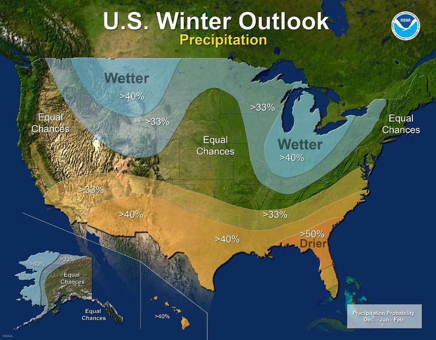
Outlook for Winter 2017-2018 into early Spring 2018:
The overall forecast for West Central and Southwest Florida for the upcoming winter and early
spring is for a better chance of below normal rainfall and near to slightly above normal
temperatures as seen in the Climate Prediction Center Winter Outlook graphics below.
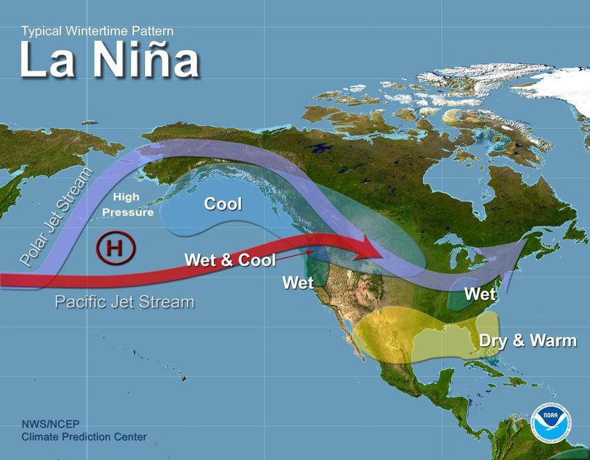
If we get a typical La Niña we should have numerous fair and mild days during this time which
will be great for the vacationers, but not so good for our landscapes. There will likely be a few
freezes across the region, especially over the Nature Coast, but prolonged cold weather is not
anticipated at this time. Drought conditions will also likely develop across some of the region
leading to water management issues along with an eventual increased wildfire threat next
spring.

On the following pages is information about how La Niña affects the weather across West
Central and Southwest Florida and what is expected during the upcoming winter/early spring.
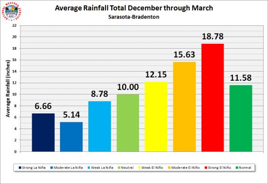
History:
We had weak La Niña conditions last winter, then neutral conditions developed this past
summer, and now a weak to moderate La Niña is expected to return this winter. As is typical
during La Niña winters we saw below normal rainfall with temperatures a couple of degrees
above average last year and this is what is expected this winter into next spring. Before this a
previous moderate to strong La Niña was a prolonged episode that lasted from the fall of 1998
to spring 2001. During these three winters rainfall across much of the area was below normal
with most areas receiving only about 50 percent of the normal rainfall.

Rainfall:
During La Niña there tends to be less stormy conditions across the Florida peninsula during the
winter and early spring. Cold fronts will move across the region, but since the mid/upper level
energy usually remains well north of the area, rainfall is limited and therefore below average.
This can be seen in the graphics below where rainfall totals during the dry season average much
lower during La Niña winters then during El Niño winters.

Another way to see this is by viewing the Box and Whisker Distribution Plots* for the three
climate zones across the Florida peninsula shown below:

   Northern Florida Peninsula        Central Florida Peninsula       Southern Florida Peninsula

       * To better understand these plots visit the following CPC web page:
       http://www.cpc.ncep.noaa.gov/products/precip/CWlink/ENSO/box_whiskers/info.php

Temperatures:
The link between ENSO and wintertime temperatures is a little bit weaker. With the average
storm track farther north during La Niña we usually see drier air over the state with more fair
weather days. This drier air leads to warmer daytime and slightly cooler nighttime
temperatures that overall result in slightly above average temperatures across the area. This is
in contrast to El Niño which tends to average slightly below normal thanks to the increased
clouds and rain that keep daytime highs cooler.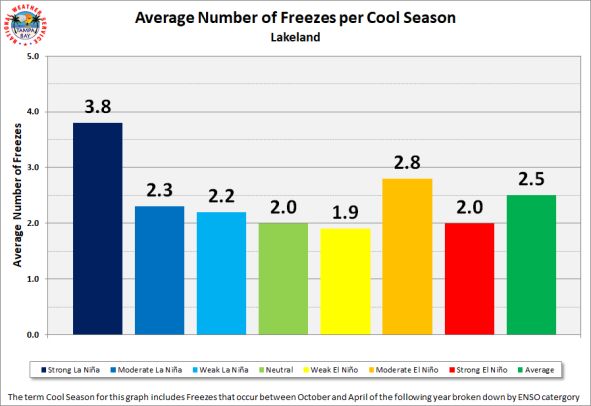
This can also be seen in the Box and Whisker Distribution Plots* for the three climate zones
across the Florida peninsula shown below:
Northern Florida Peninsula Central Florida Peninsula Southern Florida Peninsula
* To better understand these plots visit the following web page:
http://www.cpc.ncep.noaa.gov/products/precip/CWlink/ENSO/box_whiskers/info.php
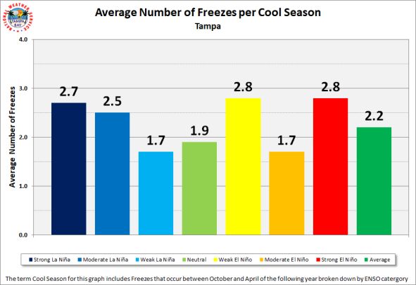
Freezes:
Freezing temperatures are possible into Central and South Florida during La Niña winters.
However, the impact of the Arctic Oscillation (AO) and North Atlantic Oscillation (NAO) play a
larger role in controlling temperatures across Florida during the winter and early spring as we
saw a few years ago (see the article about the January 2010 Cold Snap at the bottom of our
2010 Winter Newsletter for more details about the AO/NAO). These oscillations shift on a
monthly and sometimes weekly basis and typically are not included in long term forecasts.
During La Niña conditions the likely cause of freezing temperatures is radiational cooling under
clear skies and calm winds. This is unlike El Niño with advective freezes where cold air is
dragged southward behind low pressure systems that pass across the state.
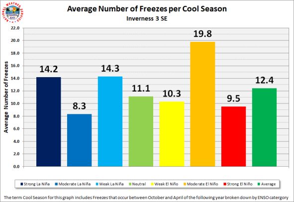
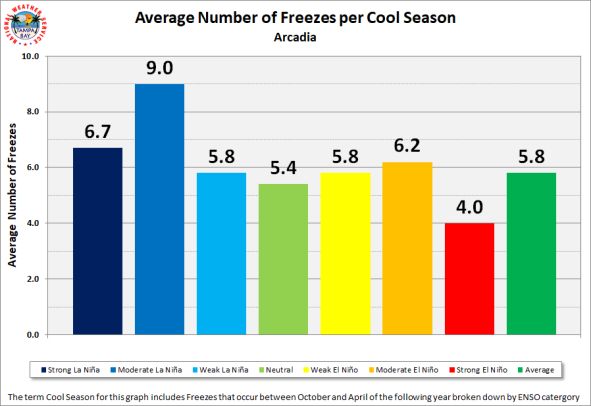
Long term averages indicate three to six days of freezing temperatures each winter across
inland portions of Central Florida with only about one freeze over Southwest Florida. Farther
north across the Nature Coast many more days of freezing temperatures occur with some
locations such as Inverness and Bushnell having on average around 12 days, while further north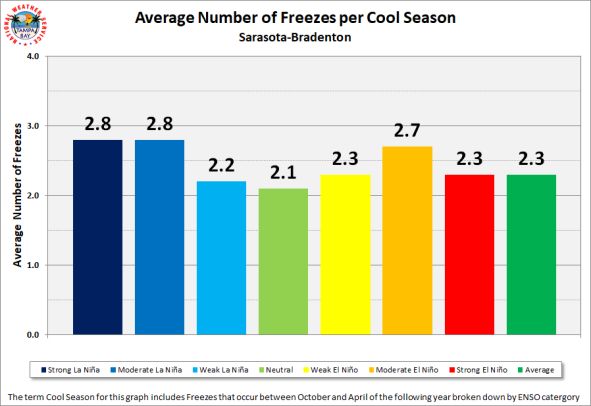
near Chiefland there are as many as 20 days with temperatures falling to or below freezing each
winter. Overall the difference in the number of days with freezing temperatures is not that
much between La Niña winters and El Niño winters as seen in the following graphics.

Residents of West Central and Southwest Florida should remain informed of potential weather
events this upcoming winter and early spring and stay tuned to local media outlets and NOAA
Weather Radio for the latest weather information.
Other Web Sites:
NOAA Winter Outlook Press Release
http://www.noaa.gov/media-release/us-winter-outlook-noaa-forecasters-predict-cooler-wetter-north-
and-warmer-drier-south

Current Drought Conditions in Florida
http://droughtmonitor.unl.edu/CurrentMap/StateDroughtMonitor.aspx?FL

Drought Outlook
http://www.cpc.ncep.noaa.gov/products/expert_assessment/sdo_summary.php

Drought Impact Reporter
http://droughtreporter.unl.edu/

NWS Tampa Bay Local Drought Page
http://www.weather.gov/tbw/droughtinfo

Climate Prediction Center
http://www.cpc.ncep.noaa.gov/

Florida Division of Forestry
http://www.freshfromflorida.com/Divisions-Offices/Florida-Forest-Service

Southwest Florida Water Management District
http://www.swfwmd.state.fl.us/

South Florida Water Management District
https://www.sfwmd.gov/

Suwannee River Water Management District
http://fl-suwanneeriver.civicplus.com/

USGS Water Information System
https://waterdata.usgs.gov/fl/nwis/
You can also read