From COP 21 to COP 22, new challenges for space agencies on climate: greenhouse gasses and water resources measurements from space - CNES - UNOOSA
←
→
Page content transcription
If your browser does not render page correctly, please read the page content below
CNES
  From COP 21 to COP 22, new challenges for
space agencies on climate: greenhouse gasses
and water resources measurements from space

                        CNES
   Authors: P. Ultre-Guerard, C. Deniel, S. Cherchali
          Presented by Dr. Paolo BAIOCCO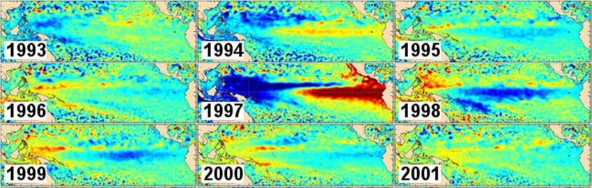
Objectives of EO : Advanced Earth Sciences

                                                        Oceanography
    Atmosphere                                          Cryosphere
    and Climate
    Monitoring

       Land areas

                                                     Solid Earth
        + Interfaces, Carbon cycles, Water cycles…   Geomagnetism
2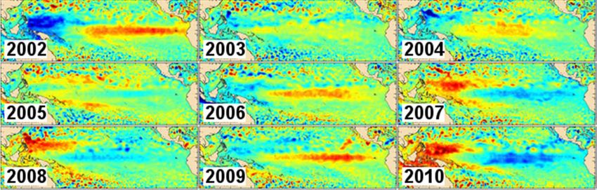
Objectives of EO: Inform decision (societal
    benefit)

3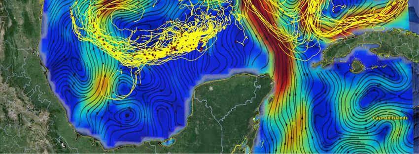
Success stories

Some examples…
Numerical
    weather prediction

5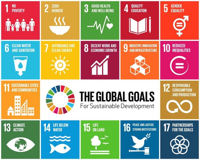
Observation
                                                                                          Atmosphere/Weather
                                                      IASI and IASI-NG
                                                       (Infrared Atmospheric Sounding
                                                                Interferometer)
                                                     Breakthroughs for meteorology and
© CNES/ill. D. Ducros
                                                     determining the composition of the
                                                                  atmosphere

                A CNES/EUMETSAT programme
                   An essential instrument in the payload of the 3 European polar-
                   orbiting meteorological satellites, MetOp (A & B) and MetOp-SG, due
                   to its Fourier transform interferometer.

                   Has resulted in improved 6-day weather forecasts. Provides air-
                   pollution alerts 1 or 2 days in advance.

                   First flight model launched in October 2006 on MetOp-A. Second
                   model launched on MetOp-B in September 2012.

                   The three IASI-NG models are under development.

                             Launch of the third IASI model in 2018
                             and of the first IASI-NG model in 2021
    6
Seasonal variations El Niño/La Niña using altimetry data

Monthly averages
maps (in cm) on
Novembers each
year since 1993, over
the Equatorial Pacific
from the El Niño
Bulletin. The time
series of the
standardized Sea
Level Anomalies is
also displayed and
updated on the
Indicator page.
Credits CLS/CNES

 7
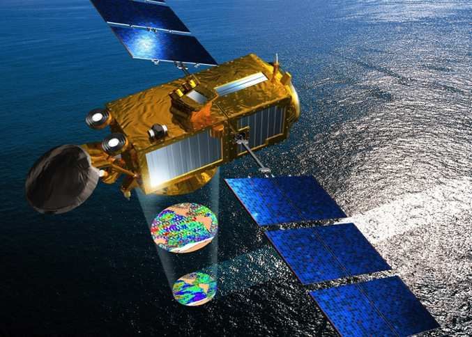
Observation
                                                                                                Oceanography

                           The Jason series
                                     Towards operational oceanography

           A CNES/NASA project (expanded to include NOAA
                                        and EUMETSAT).
          Following on from operational meteorology,
          Jason 2 was able to demonstrate operational
          oceanography.

          The programme is being continued with Jason 3,
          which shares many of Jason 2’s characteristics.

          The follow-up to Jason 3 is already planned. This
          will be Jason CS (for "Continuity of Service"), the           © CNES/ill. D. Ducros

          sixth Sentinel satellite of the Copernicus                    Jason 3 was launched on 17 January 2016
          programme.

8   General presentation of CNES – June 2016
New challenges : climate
UN Sustainable Development Goals

10
1) Greenhouse Gases observation
from Space
12 General presentation of CNES – July 2014
MICROCARB & MERLIN

                                                        MERLIN : CH4 Active measurement
                                                            Accuracy< 27 ppb Bias < 3,7 ppb
                                                   •   DIAL Lidar at 1,67 µm
                                                   •   Horizontal sampling accumulation: 50 km
                                                   •   To be launched in 2021

     MICROCARB : CO2 Passive measurement
            Accuracy< 1 ppm Bias < 0,1 ppm
      • XCO2 spatial gradients are small (< 10 ppm)
      • Error on measurement (regional bias) implies
                  wrong flux computation
     • To be launched in 2020
13   General presentation of CNES – July 2014
Growing interest in CO2 and CH4 Observations from
space
Japan:
GOSAT (JAXA/NIES/MoE), launched in 2009.
GOSAT-2 (JAXA/NIES/MoE), planned for 2018.
USA:
OCO-2 (NASA), launched in 2014.
OCO-3 (NASA), planned in or after 2018.
GEOCARB (NASA), planned for ?
ASCENDS (NASA), under study (2023+).
China:
TanSat (CAS, MOST, CMA) launched in 2016.
Europe:
COPERNICUS/Sentinel 5P (ESA) & 5 (UE) , planned for 2017 & 2021.
MERLIN (CNES-DLR), planned for 2021.
MICROCARB (CNES), planned for 2020.
14 General presentation of CNES – JulySentinel
2014 7 (ESA/UE), TBC, for 20252) Water cycle and fresh water resources from Space
16
Observation
                                                          Oceanography/Hydrology

                                      SWOT (Surface Water Ocean Topography Mission )
                                                       Monitoring the level of oceans and inland waters

                                        A joint CNES/NASA/UKSA/CSA/ project to map variations in
                                        the levels of inland and ocean waters.

                                        CNES is providing the platform and co-operating with NASA on
                                        the instruments, in particular the highly-innovative KaRIn wide-
                                        swath altimeter.

                                        CNES is also in charge of the satellite’s ground control
                                        segment and is developing (jointly with NASA) a mission
                                        ground segment for data processing.
                                        The French contribution is partly financed by the French future
© CNES/ill. D. Ducros                   investments programme (PIA).
          Launch scheduled for 2021

17
Going from large scale to smaller scale monitoring
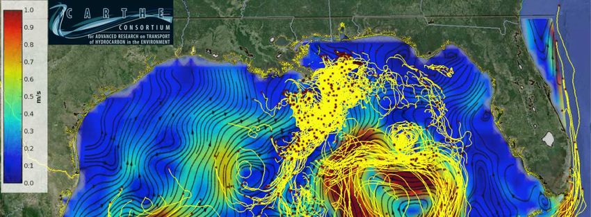
New generation of altimetry measurements for oceanography
Example: Ocean dynamics in the Gulf of Mexico
- The colored map depicts the ocean circulation as it is
monitored by current satellite altimetry
- Yellow lines shows the actual trajectory or surface
drifters
From nadir to wide swath
altimetry
18SWOT Coverage Leap - from local altimetry to topography
Conventional Nadir Altimeter SWATH Altimeter : SWOT
SWOT mission will address challenges and shortcomings of conventional altimetry (e.g.,
spatial coverage and resolution) in both oceanographic and hydrologic applications and
will enable a wide range of research opportunities in oceanography and land hydrology.
19
19International cooperation
From COP 21 to COP 22
Marrakech Declaration –
Water cycle and fresh water
resources
20Thank you for your attention! 21
You can also read