WHERE (EXACTLY) ARE MY THINGS? LEARN HOW GALILEO CAN EMPOWER YOUR IOT SOLUTION - CARMEN AGUILERA, JUSTYNA REDELKIEWICZ - EUROPEAN GNSS AGENCY - AIOTI

Page created by Danielle Barnes
 
CONTINUE READING
WHERE (EXACTLY) ARE MY THINGS? LEARN HOW GALILEO CAN EMPOWER YOUR IOT SOLUTION - CARMEN AGUILERA, JUSTYNA REDELKIEWICZ - EUROPEAN GNSS AGENCY - AIOTI
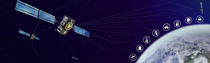
Where (exactly) are my things? Learn how Galileo can
empower your IoT solution

Carmen Aguilera, Justyna Redelkiewicz - European GNSS Agency

November 2018                                                  1
WHERE (EXACTLY) ARE MY THINGS? LEARN HOW GALILEO CAN EMPOWER YOUR IOT SOLUTION - CARMEN AGUILERA, JUSTYNA REDELKIEWICZ - EUROPEAN GNSS AGENCY - AIOTI
The European GNSS Agency (GSA) is responsible for
market development and operations of Galileo and EGNOS

• Staff: around 160
• Nationalities: 22
• Headquarters: Prague,
  Czech Republic
• Other Locations:
  • France
  • The Netherlands
  • Spain
  • United Kingdom
WHERE (EXACTLY) ARE MY THINGS? LEARN HOW GALILEO CAN EMPOWER YOUR IOT SOLUTION - CARMEN AGUILERA, JUSTYNA REDELKIEWICZ - EUROPEAN GNSS AGENCY - AIOTI
Galileo and EGNOS are the European GNSS programmes

                         Worldwide GNSS system “made in EU”
European GNSS (EGNSS)

                         Delivering free of charge Open service and High accuracy service
  location and timing

                         26 satellites already launched
                         Initial Service Capability declared in 2016 and Full Operational Capability planned in 2020

                                                       Regional Satellite Based Augmentation System
                                                       Improves GNSS performance by providing improved accuracy and integrity
                                                       European coverage
                                                       Fully operational, free of charge and widely used in Europe since 2011

                                                                                                                                 3
WHERE (EXACTLY) ARE MY THINGS? LEARN HOW GALILEO CAN EMPOWER YOUR IOT SOLUTION - CARMEN AGUILERA, JUSTYNA REDELKIEWICZ - EUROPEAN GNSS AGENCY - AIOTI
The Galileo implementation plan accelerates with Initial
Services in 2016 and Enhanced Services in 2019

                                        Galileo is implemented in a step-wise approach
                                 •    26 satellites have been launched
                                 •    4 satellites are in production/being procured:
                                       • The remaining ones by 2020
                                                               Initial Operational Capability
                                     2016
                                                      Initial services for Open Service (OS)
                                     2019
                                                          Search and Rescue Service (SAR)
                                                             Public Regulated Service (PRS)
                                          and demonstrator for High accuracy Service (HAS)
                                                                                 Test signal for
      Last Galileo launch:           2019
        25th of July 2018                               OS Navigation Message Authentication
   4 satellites launched in an                               (OS-NMA) and High Accuracy (HA)
    Ariane 5 launcher from                                         Full Operational Capability
              Kourou                   2020                          Full services, 30 satellites
                                                         An independent civilian infrastructure
                                                                                        4
WHERE (EXACTLY) ARE MY THINGS? LEARN HOW GALILEO CAN EMPOWER YOUR IOT SOLUTION - CARMEN AGUILERA, JUSTYNA REDELKIEWICZ - EUROPEAN GNSS AGENCY - AIOTI
Galileo is used today in professional and consumer
devices, including IoT chipset platforms
WHERE (EXACTLY) ARE MY THINGS? LEARN HOW GALILEO CAN EMPOWER YOUR IOT SOLUTION - CARMEN AGUILERA, JUSTYNA REDELKIEWICZ - EUROPEAN GNSS AGENCY - AIOTI
The continuous evolution of GNSS infrastructure responds to the
increasing user demand

                                             All global and regional GNSS
                                            constellations are developing,
                                             modernising and innovating,
                                              with more than 100 GNSS
                                                satellites now available

                                                                             6
WHERE (EXACTLY) ARE MY THINGS? LEARN HOW GALILEO CAN EMPOWER YOUR IOT SOLUTION - CARMEN AGUILERA, JUSTYNA REDELKIEWICZ - EUROPEAN GNSS AGENCY - AIOTI
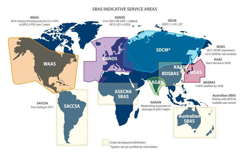
In addition to the global services, the SBAS coverage is increasing

                                                                      7
WHERE (EXACTLY) ARE MY THINGS? LEARN HOW GALILEO CAN EMPOWER YOUR IOT SOLUTION - CARMEN AGUILERA, JUSTYNA REDELKIEWICZ - EUROPEAN GNSS AGENCY - AIOTI
The users requirements for positioning
differ significantly by application area

                                           8
WHERE (EXACTLY) ARE MY THINGS? LEARN HOW GALILEO CAN EMPOWER YOUR IOT SOLUTION - CARMEN AGUILERA, JUSTYNA REDELKIEWICZ - EUROPEAN GNSS AGENCY - AIOTI
Several technologies can provide positioning capabilities
relevant to locate “things”
                          Main absolute positioning technologies and accuracy

       •   Network based: (Cell-ID, E-OTD, TDOA etc.) using the telecommunication networks

       •   Handset based: (GNSS) the handset itself is the primary means of positioning the user. The A-GNSS
           corresponds to a hybrid technology based on the GNSS but using the cellular network

       •   Infrastructure based: (Bluetooth, UWB, Wi-Fi or RFID) the position is computed by evaluating of
           the distance between the device and transmitters (for example a Bluetooth beacon or a Wi-FI
           router)
WHERE (EXACTLY) ARE MY THINGS? LEARN HOW GALILEO CAN EMPOWER YOUR IOT SOLUTION - CARMEN AGUILERA, JUSTYNA REDELKIEWICZ - EUROPEAN GNSS AGENCY - AIOTI
GNSS in IoT: the use today and in near future
                                     Global shipments of GNSS IoT devices by type
                     140
Millions

                     120

                     100
 Shipments (units)

                      80

                      60                                                                                                                                Global shipments of GNSS IoT devices by region
                                                                                                                                                  140

                                                                                                                                       Millions
                      40
                                                                                                                                                  120
                      20
                                                                                                                                                  100

                                                                                                                   Shipments (units)
                       0
                                                                                                                                                  80
                              2015          2016   2017           2018          2019           2020         2021

                                                                                                                                                  60
                       Wearable sports devices     Fixed / handheld sports devices     Tracking of things
                       Tracking of people          Bike sharing
                                                                                                                                                  40

                                                                                                                                                  20

                                                                                                                                                   0
                                                                                                                                                         2015         2016      2017           2018          2019        2020         2021

                                                                                                                                       EU28         Non-EU28 Europe   North America    Asia-Pacific   Middle East and Africa   South America
                                                                                                                                                                                                                                      10
The demand for better location performance is driving the
 evolution of GNSS technology along three main areas

         Ubiquity                            Accuracy                           Security

As PNT applications continue to   The development of new semi-       Addressing jamming and spoofing
expand in consumer and            professional applications          is key especially where PNT is at
commercial segments, demand is    supported by mobile devices is     the core of safety-critical or
also growing for uninterrupted,   pulling the demand for increased   commercially sensitive
ubiquitous, and seamless access   location accuracy                  applications
                                                                                                         11
to position information
Ubiquity:
    Ubiquity High availability of location information
is increasingly demanded by IoT applications

     Floating sharing
                                      Autonomous robots
                                                                            Elderly people
                                                                              monitoring

             Lone worker protection                       Law enforcement                    12
Ubiquity    What works best in geolocation?
           Multi-constellation for better availability

                                               Multi – constellation is already widely
                                                     used in many applications

                                                 The most popular way to provide
                                                 multi-constellation support is to
                                                  cover all constellations, which
                                                 represents over 30% of receivers

                                                      Main benefits include:
                                                      Increased availability
                                                       Increased accuracy
                                                      Improved robustness

                                                                                         13
AccuracyEmerging applications are more and more
demanding in terms of accuracy

     Augmented reality   Self-driving cars   Drones

        mHealth          Autonomous robots   Smart farming
                                                             14
Accuracy   Augmented Reality (AR) adds value both to
high precision and mass market applications
    The use of AR in high precision market includes:

    City Planning:
     In-situ design

    Construction:
     Showcase projects
     Control progress of work and anticipate
       problems

    Mining:
     Definition of mining area
     Assessment of environmental licensing
       scenarios

    In mass market AR is used by a large number of
    applications for:

     Image recognition                                GNSS receivers already meet the key
     Overlay basic information on outdoor locations   performance parameters required to
                                                       enable AR: Accuracy and Availability
                                                                                              15
Accuracy Autonomous vehicles drive the accuracy
and robustness requirements

     Audi and Italdesign presenting Pop.Up in 2018           NEXT self-driving pods – live tested in Dubai 2018

          Above innovations are not possible without high precision positioning and navigation:
                                  -management of autonomous fleet
                              -navigation to customer and to destination
                   -precise “docking” of drones on the vehicles and merging of pods
                                                                                                                  16
Accuracy Positioning is among the challenges that the
drone market has to address to develop to its full potential

                                  Challenges for the drone market:

                                     Precise and reliable tracking information
                                     Diverse connectivity requirements
                                     Hybridisation of various data sources
                                     Harmonisation of regulation

                                                                                  17
Accuracy Many mHealth applications rely on GNSS,
some of them with high accuracy needs
                                                Main mHealth application categories leverage fusion of
 Mobile Health (mHealth) is a sub-segment of
                                                big data with GNSS:
 eHealth and covers medical and public health
 practice supported by mobile devices
                                                Disability assistance:
                                                 Navigation solutions for the blind
                                                 Navigation solutions for upper/lower body-impaired
                                                   individuals
                                                 Tracking of Alzheimer patients

                                                Well-being:
                                                 Wearable tracking devices for leisure purposes
                                                 Wearable tracking devices for professional sports

                                                Emergency:
                                                 Personal location beacons for Search and Rescue (SAR)
                                                 Disaster management smartphone-based applications

                                                                                                          18
Accuracy   Autonomous robots require high levels
of precision to navigate
 Real world objects and their position in relation
  to the robot need to be understood with a high
  degree of precision

 To mitigate the risk of a robot entering an area it
  should not, GNSS-based geofencing is being
  increasingly utilised thanks to its accuracy and
  availability

                                                        19
GNSS is at the core of main Smart
         Accuracy

   Farming applications requiring high precision
                                AUTONOMOUS FARM

       Earth
       Observation              Drones         GNSS                              GNSS is used for:

                                                                                    • Navigating
Meteo Data                                                                          autonomous
                                                                                tractors/harvesters
                                                                                    • Positioning
                                                                 Precision            of drones
                                                                 Farming      • Navigation of swarm
                                                                                       robots
                                                    Big Data                   • Geotagging of earth
             IoT                                                                 observation data
                                         Connectivity                        • Positioning of assets on
                                                                                      the farm
                                                                                • Geotraceability of
                     Swarm                                                      agriculture products
                     Robotics            Advisors
                                                               Farmer
Accuracy          What works best in geolocation?

         Multi-frequency for better accuracy and robustness

    Receivers beyond traditional high-
precision applications are also demanding
 performance that can best be supported
           by multi-frequency

This has resulted in a drop of nearly 10%
 in the production of receivers that are
            single-frequency
      only, over the last two years

         Main benefits include:
          Increased accuracy
         Improved robustness

                                                              21
AccuracyDual-frequency entered mass market
addressing consumer demand for accuracy

First dual frequency phone was      Dual frequency enters the functional
      launched in May 2018           safety automotive grade receivers

             Xiaomi Mi8
                                       GSA funded project ESCAPE develops the
    Powered by Broadcom 4775
                                         highly automated positioning engine
   Dual frequency E1/L1 and E5/L5

                                                                                22
Accuracy   Why E5/L5 is the best second frequency of
choice for your solution?

  Wide band signal providing increased accuracy

  Exceptional resistance to multipath

  In combination with E1 providing iono-free
  solution

  All constellations support this frequency, the
  number of available signals will grow rapidly

  E1/E5 combination is recognized in all segments,
  professional, automotive and also mass market
Accuracy  Galileo can further contribute to IoT with its
  innovative High Accuracy Service
                                                     Characteristics
High Accuracy
    Based on PPP transmission in E6B   User positioning accuracy with decimeter
    FREE provision                     level error      (≈20cm)
                                        No need of additional ground
                                        communication channel (448 bps allocated
                                        on Galileo E6B)
                                        No need of proximity to base stations to
                                        access corrections (as opposite to RTK)

                                        Triple frequency to further increase accuracy
                                        and reduce PPP convergence time

                                        Improved line-of-sight and better coverage
                                        at high latitudes
Security   Authentication of position is expected to
reduce the associated spoofing and jamming risk in many
application categories

       Road                    Logistics                  Mobile
 (AD, PAYD, RUC)          (proof of delivery)            payments
                                                                                Timing &
                                                                             Synchronisation

      Commercial Marine              Augmented Reality              Drones
Security   Spoofing, the emerging threat

                                           26
OS-NMA, the unique Galileo
       Security

Authentication feature will bring more benefits to IoT
                                                                  Characteristics
Authentication
       Data level: Navigation Message Authentication   Contributes to mitigate a well known GNSS
         Integrated in the E1-B band for OS. Aimed at   vulnerability (spoofing)
         consumer users and offered for free. Already
         prototyped and under testing                   Clear differentiator w.r.t. other GNSS available
                                                        to the civil community

                                                        Fully backward compatible. Does not affect
“Navigation Message                                     users not interested
Authentication” is defined as the
ability of the system to guarantee                      Disseminated on the first Galileo frequency
to the users that they are utilising                    (E1B)
non-counterfeit navigation data
                                                        Open access: asymmetric cryptography. No
that comes from the Galileo                             need to store secret keys in the Rx, just public
satellites and not from any other                       key
(potentially malicious) source
                                                        Long-term cryptographically secure
                                                                                                           27
Security    OS-NMA is being prototyped

     Autonomous Driving positioning engine for
      vehicles (ESCAPE)

     Smart Tachograph OS-NMA enabled user
      terminal (PATROL)

     Autonomous driving positioning engine for
      trucks (ProPART)

     Professional grade GNSS technology (FANTASTIC)
                                                       28
Gradual implementation of Galileo new features

   2018     Dual/tripple frequency capability available

                             OS-NMA Live signals
                 2019        (TEST mode)

                                   2020       HAS Initial Services

                           TEST SIS OS-NMA

                                                                     29
Internet of Things segmentation
(from GNSS provider perspective)
                                                               TODAY         TOMORROW
  HIGH END
  Lower power consumption and cost constraints
                                                    Multi- constellation       Multi-frequency
    (fleet management, drones, smartphones)

 MID RANGE
 Medium power consumption and cost constraints
  (asset tracking, wearables, bike sharing, smart     GPS – only              Multi-constellation
                     lightning)

  LOW END

  High power consumption and cost constraints          No GNSS                Innovative concepts
   (low value asset management and tracking)                               (e.g. cloud processing)

                                                                                                     30
Get the GSA reports on GNSS market and technology to
support your planning and decision making

 The GNSS Market Report is a comprehensive    The GNSS User Technology Report, a sister
 source of knowledge and information on the   publication to the GSA’s GNSS Market Report, is
 dynamic, global GNSS market. The report is   published every two years and takes an in-
 published every two years, with the latest   depth look at the latest state-of-the-art GNSS
 edition released in 2017                     receiver technology

                                                              https://www.gsa.europa.eu/europ
  Download       https://www.gsa.europa.eu/    Download
                                                              ean-gnss/gnss-market/gnss-user-
  for free at    market/market-report          for free at
                                                              technology-report                 31
Support EU competitive offer: Funding mechanisms
promote the development of Galileo within apps
and receivers

    Aims to foster adoption of EGNSS via                                       Fundamental Elements projects focus
    content and application development                                        on fostering the development of
    and supports the integration of services                                   innovative Galileo- and EGNOS-enabled
    provided by these programmes into                                          receivers, antennas and chipsets
    devices and their commercialisation                                        technologies

                                        http://www.gsa.europa.eu/r-d/gnss-r-d-programmes
                                                                                                                       32
The new H2020 call is open! H2020-SPACE-
EGNSS-2019
                                                                Indicative
    Type of
    Action
                                  Topic                           budget          Funding rate
                                                                 (EUR mln)

              EGNSS applications fostering green, safe                                                              Participation of SMEs is strongly
      IA                                                          10.00                                             encouraged!
              and smart mobility
                                                                                       70%                          Proposals addressing PRS (Public
      IA      EGNSS applications fostering digitisation            4.00       (except for non-profit                Regulated Service) are not in the
                                                                              legal entities, where a               scope of this action
                                                                               rate of 100% applies)
              EGNSS applications fostering societal
                                                                                                                    A combination of EGNSS with
      IA      resilience and protecting the                        4.00                                             other technologies required to
              environment                                                                                           make the application(s) work, is
                                                                                                                    also encouraged
              EGNSS awareness raising and capacity
     CSA
              building
                                                                   2.00               100%
                                                                                                                 Opening: 16 October 2018
                                          TOTAL budget:              20.00                                       Deadline: 05 March 2019

      IA: activities aimed at producing plans and arrangements or designs for new, altered or improved products, processes or services
      CSA: consisting of accompanying measures such as standardisation, dissemination, awareness-raising and communication, networking, policy dialogues
      and studies
                                                                                                                                                           33
Linking space to user needs
How to get in touch:

             GSA Newsletter                      GNSS YouTube Channel

             GSA Twitter - @EU_GNSS              European GNSS Agency LinkedIn Page
             EGNOS Twitter - @EGNOSPortal        GNSS Market, Research & Development

             GNSS Facebook page                  GNSS Slideshare Page (presentations)

                                       www.GSA.europa.eu
                                                                                        34
Security  With OS-NMA, users can verify that signal
comes from a Galileo satellite and not from a potentially
malicious source

                                                            35
You can also read