Where the Wild Things Will Be: Adaptive Visualisation with Spatial Computing - VDE-Verlag
←
→
Page content transcription
If your browser does not render page correctly, please read the page content below
140                                                                                           Full Paper

Where the Wild Things Will Be:
Adaptive Visualisation with Spatial Computing
Adam Tomkins1, Eckart Lange2
1The   University of Sheffield/UK · a.tomkins@sheffield.ac.uk
2The   University of Sheffield/UK

Abstract: Augmented Reality is increasingly being used as a tool for education and communication.
However, applications tend to be limited to a single-use case, due to the complexity of adapting in-situ
visualisations to different environments and topographies. In this paper we propose a novel adaptive
visualisation workflow designed to embed large-scale visualisations with temporal dynamics within
arbitrary environments, using dynamic spatial mapping. We build a generic parameterised method to
create interactive, explorable visualisations of progressive environmental augmentations. We demon-
strate how this system could be used to simulate a simplified rewilding visualisation for use in education
and stakeholder participation, allowing participants to explore potential ecological changes in-situ.
Keywords: Augmented Reality, visualisation, spatial computing, occlusion, rewilding

1       Introduction
The United Nations General Assembly has recently declared 2021-2030 the decade of eco-
systems restoration (UNITED NATIONS 2019). Rewilding has been proposed as one path to
achieving the ambitious vision of a restored level of biodiversity by 2050. Rewilding is a
progressive approach towards nature restoration, which aims to restore complex ecosystems
while minimising human interventions (LORIMER et al. 2015). The widespread acceptance of
afforestation efforts will need innovative public policy solutions, backed by public under-
standing and support (SANDOM & WYNNE-JONES 2019). This is achieved by a communica-
tion strategy that involves affected communities in decision making as well as outreach ac-
tivities that inform the wider public about the outcomes of interventions, potentially including
opportunities for nature experiences such as guided tours through the area in question.
Visualisation plays an important role in stakeholder participation (LANGE 2011). Since the
early before-and-after visualisations of Humphry Repton (REPTON 1980), we have used de-
velopments in visualisation technology to improve the communication of the effects of pro-
posed landscape interventions. Augmented reality (AR) has been used since its inception, as
a method to enrich visualisation and communication techniques. Recent developments in AR
hardware has led to a resurgence of AR applications in landscape architecture (GOUDARZNIA,
PIETSCH & KRUG 2017, HAYNES, HEHL-LANGE & LANGE 2018, SORIA & ROTH 2018,
TOMKINS & LANGE 2019), however realistic occlusion has been a barrier to the effectiveness
of on-site visualisation (LI et al. 2018).
Realistic occlusion without environmental understanding is a difficult task in AR application
development. Marker-based AR is one widespread technique, which requires detailed mod-
elling and laborious spatial calibration ahead of time to get convincing results, leading to
either site-specific single-use applications without environmental occlusion (GOUDARZNIA et
al. 2017, SORIA & ROTH 2018), or more generic applications with no interaction with the
surrounding environment (TOMKINS & LANGE 2019, 2020).

Journal of Digital Landscape Architecture, 6-2021, pp. 140-147. © Wichmann Verlag, VDE VERLAG GMBH ·
Berlin · Offenbach. ISBN 978-3-87907-705-2, ISSN 2367-4253, doi:10.14627/537705011.
A. Tomkins, E. Lange: Where the Wild Things Will Be                                        141

Haynes et al. (2018) have demonstrated an innovative, yet time-consuming manual approach
to roughly mapping the spatial profile of an area using primitive shapes to create simple
occlusion geometries (HAYNES et al. 2018). While this approach is feasible for small areas,
its application would be problematic for complex or larger natural environments, and entirely
unsuited to free exploration. These limitations pose a problem in harnessing the immersive
power of Augmented Reality visualisation to affect change in large scale projects, such as
the Rewilding Britain Initiative (SANDOM & WYNNE-JONES 2019), which are spread across
many sites, or in projects with undefined sites, such as you find in outreach and education
programs.
Site-specific outcomes are heavily influential in the acceptance and success of rewilding en-
deavours (CEAUSU et al. 2019), severely limiting the transformational role of single-use ap-
plications across multi-site projects. If AR is to play a role in large scale projects, we need
an approach which can be applied to sites in which the environment is unknown in advance.
The development of spatial mapping in wireless AR headsets may offer the chance to develop
applications which work with the local topography, without prior knowledge, applicable
across multiple sites without spatial recalibration.
To assess the ability of the latest AR hardware to address these limitations, we must adapt
the way we build AR experiences, moving away from the visualisation of specific interven-
tions, to building adaptive visualisations through procedural generation reactive to the im-
mediate environment. We introduce the Adaptive Visualisation Workflow to dynamically
visualise landscape augmentations, through a user-guided exploration process, constrained
by pre-defined parameterized stages, which adapt to the local topography. By defining a set
of simplified temporal stages to approximate the progression through the natural succession
of plant recolonization of human-dominated landscapes (BILLINGS 1938), we show an exam-
ple of how this generic visualisation engine could be used to explore a phenomenological
visualisation of the rewilding process in-situ. With this work, we aim to let people experience
the evolution of their wild spaces, learning not in a lab, but upon the very land concerned.

2     Methods
For this project, we have created a new Augmented Reality application for the wireless Mi-
crosoft HoloLens 2 headset. We built our application within the Unity Game Engine, using
the Mixed Reality Toolkit (MRTK) Spatial Mapping library to build and interact with a con-
tinuously maintained spatial mesh of the world around the user. The dynamic mapping pro-
cess ensures that no prior knowledge of topography, nor prior modelling of the intervention
is required. To maintain a generic application, our experiences are designed by configuring
a set of independent visualisation stages akin to snapshots in time, which are incorporated
into the Adaptive Visualisation Workflow, as explained in section 2.1.

2.1   The Adaptive Visualisation Workflow
To create our AR experiences, we follow an adaptive visualisation workflow, driven by the
interplay of user exploration, local topography and a configuration based scenario, shown in
figure 1. The adaptive visualisation workflow aims to frame how we build AR experiences
which explore procedurally generated scenarios in response to the immediate environment,
using the on-site dynamic mapping process shown in figure 2. We create experiences which
142 Journal of Digital Landscape Architecture · 6-2021
can be used across sites, yet capture the underlying traits determined by pre-configured pa-
rameterisations, such as species variety, prevalence, density and dynamics.
Fig. 1:
The continuous loop of the Adaptive Vis-
ualisation Workflow, driven by the inter-
actions of the user, the immediate environ-
ment and the pre-defined scenario config-
uration parameters
During the experience, while wearing the headset, we begin the cyclic workflow. As the user
explores, through walking and casting their gaze around, we build up a spatial mesh of the
environment, as shown in figure 2. The spatial mapping is restricted to approximately 3 me-
ters range from the participant, ensuring exploration is a key process to create larger-scale
visualisations. With all newly mapped areas, we use a set of the pre-defined stages, to calcu-
late how many new assets (for example, tree species) should be visualised, and of which
types. We then spatially align the new visualisations such that they are embedded in the nat-
ural undulations of the generated mesh, as shown in figure 3. With each stage calculated, the
scenario is then pruned to show only the assets required in the current stage. Finally, the
results are visualised with the headset. This is an autonomous process, with the only user
input being exploration, and the explicit commands to change the currently displayed stage.
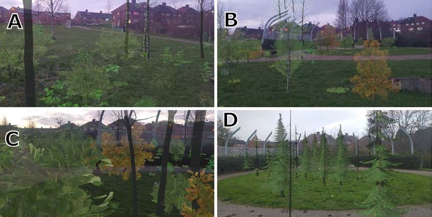
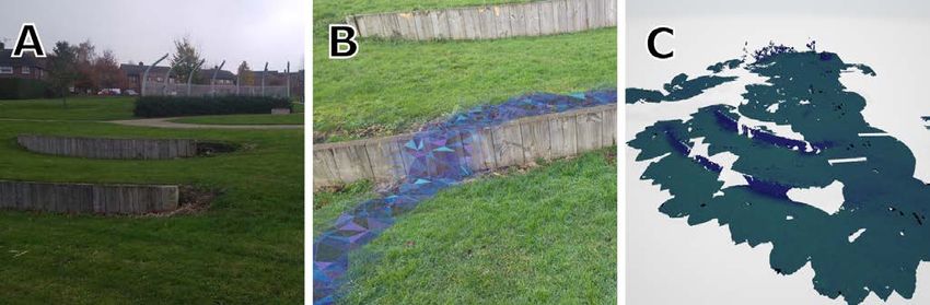
Fig. 2: On-Site Dynamic Spatial Mapping Process. (A) A multi-layered urban green space
with complex geometry. (B) The dynamic mapping process visualised as seen
through the HoloLens 2. (C) A snapshot of the 3D spatial mapping mesh of the urban
green space captured during a short walk, exported and rendered after the session.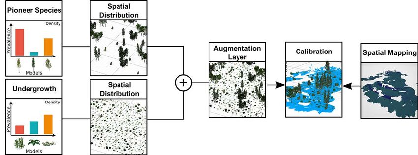
A. Tomkins, E. Lange: Where the Wild Things Will Be                                        143

2.2   Defining a Visualisation Stage
The Adaptive Visualisation Workflow is a procedurally generated process, which is adapted
to a specific scenario through the configuration of distinct stages. Stages consist of a user-
defined set of groups, or layers, which interact through their average density. Each associated
item within a group contains a 3D representation, and their associated relative prevalence
within the group, as shown in figure 3. All assets within a group share an average density
estimation, as such, stages which combine species with different dynamics, such as pioneer
trees and undergrowth, should be represented as different groups within a stage. In our ex-
ample, stages represent the temporal progression of natural plant succession seen in the re-
colonization of unmanaged land (BILLINGS 1938), with each stage including distinct tree
groups, and undergrowth groups.
The spatial distribution of items within a group is determined by iteratively adding models
as the space is mapped, ensuring the global density of items within one layer remains con-
sistent with the average density configured for the group. Individual items within a group are
picked at random, with respect to their respective prevalence. For example, varying the den-
sity and prevalence of species across succession stages can approximate the changing under-
lying make-up of forest biomass through time. An example configuration, as shown in figure
4, demonstrates a simplified progression of plant succession which can be adapted for spe-
cific sites and stages as required. Each stage after the first contains two groups, one for the
undergrowth (annual, perennial and shrub dynamics), and one for the tree species dynamics.

Fig. 3: Procedural generation of augmentations for a single-stage, build from two distinct
        groups configured with different species, prevalence and group-level densities

As stages are defined by a probability distribution through asset prevalence, each run of the
experience will create different variations on the scenario. Choosing to represent the distri-
bution in terms of prevalence and density of species groups enables a flexible way to config-
ure experience to approximate group dynamics. Parameters could be taken from theoretical
model predictions or site-specific measurements. Assets are free to be any set of objects
which can be rendered in Unity, including 3D models, billboard models and animated models
such as wildlife. In this example, we use the highly detailed European Vegetation resource
pack, from the Unity Asset Store. Stages can be progressed using a simple set of voice com-
mands giving audio feedback, which are less prone to environmental interference than holo-
graphic user interfaces. As such, the only interface to the participant is the augmentations
themselves.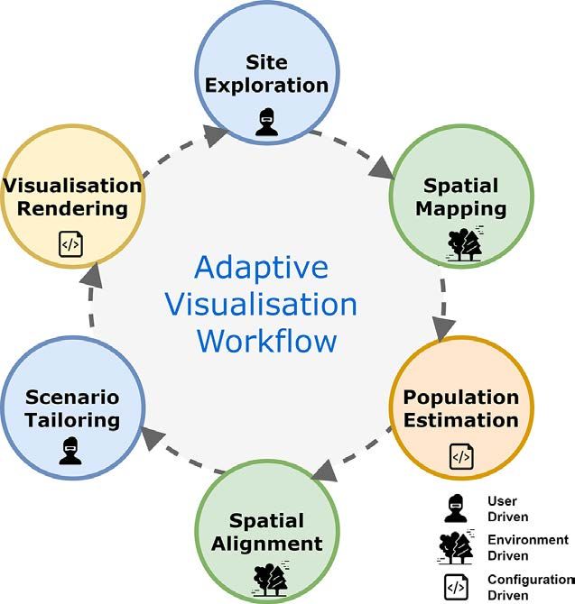
144 Journal of Digital Landscape Architecture · 6-2021
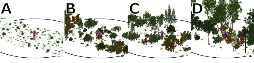
Fig. 4: An example configuration of stages to approximate plant successional stages. (A)
annual & perennial plants and grasses, (B) shrubs, (C) Early pioneer and (D) Mature
Pioneer species.
3 Results: Visualising Passive Rewilding for Education
Rewilding in the European context often emphasises a passive ecological approach to re-
wilding (SANDOM & WYNNE-JONES 2019), relying on the natural process of ecological suc-
cession for land management. Rewilding can occur in a variety of settings, and spatial scales,
from urban green spaces to abandoned agricultural landscapes (PRIOR & BRADY 2017). Here
we apply the Adaptive Visualisation Workflow to develop a proof-of-concept application to
determine the applicability of our approach to enhancing educational opportunities for nature
experiences, such as guided site tours in outreach. To achieve this, we use our procedural
visualisation engine to visualise a phenomenological configuration of plausible local out-
comes of natural plant succession, reminiscent of the unguided afforestation seen in the pas-
sive approach to rewilding.
Fig. 5: Examples of successional visualisations in an urban green space, taken through the
HoloLens headset. (A) Augmented mature pioneer Birch trees and shrubs alongside
established real trees, (B) Early pioneer species and shrubs, (C) Close up experience
of the shrub augmentations, (D) Alternative Pine dominated configuration.A. Tomkins, E. Lange: Where the Wild Things Will Be 145 We define a simplified 4 stage progression, annuals and perennials and grasses, shrubs, early pioneers and established pioneers inspired by the natural progressions found in BILLINGS, (1938), shown in figure 4. We represent the stages of pioneer succession as two separate stages, to smoothly capture the growth of the pioneer species from early colonisation to ma- turity. Each stage contains primary species, and residual species, such as undergrowth, show- ing the gradual reduction in species prevalence as the habitat becomes less favourable. In this configuration, we focus on a section of European grasses, shrubs and tree species based on what is present in the local area, mainly birch, oak and maple. Indicatively, we included the locally prevalent perennials, horsetail (Equisetum arvense) and dandelion (Ta- raxacum). Each simulation will result in a different experience, reflecting the spatially sto- chastic, but generally predictable stages of natural succession (BILLINGS 1938). Each out- come is shaped by the profile of the land itself, the path the participant has taken to explore the area, and how they have chosen to experience the progression of stages. Figure 5 shows 4 examples of the visualisations created by the HoloLens, with figures 5A, 5B and 5C showing the primary configuration based on a Birch dominated succession pro- gression. Figure 5A shows a possible pioneer stage, in conjunction with a small area of ex- ploration. We see the addition of several larger Birch trees, with smaller shrubs, and newly established maple saplings interspersed. Areas near the boundary of exploration can leave an abrupt gap in the augmentations. In contrast, figure 5B shows the early stages of pioneer growth, with augmentations present for ~30 meters in advance of the user. Figure 5C shows the visual effect of walking through the dense shrubbery, including the level of detail avail- able with close up inspection. Unfortunately, we found that the visual efficacy of the Ho- loLens is strongly affected by direct sunlight, as such these pictures were taken in the late afternoon. To create visually appealing tree models, leaves are generally created with translucent mate- rials, allowing the light behind to subtly influence the appearance of the leaves. While this produces excellent visualisations in general, when capturing the images from the HoloLens, this results in reduced visual definition. In contrast to this, Figure 5D shows a configuration using more rudimentary models of pine trees. In this case, the materials are solid and non- transparent, leading to a clearer image, but less realism. In all cases, due to the additive nature of the HoloLens, there will always be some degree of transparency, with 100% occlusion of the environment impossible. 4 Discussion In this paper we aimed to explore the applicability of an untethered headset based Augmented Reality for displaying, exploring, and interacting with changes in the immediate environ- ment, to address the drawback of single-use site-specific AR applications which are unsuited to larger project goals. We have proposed a new Adaptive Visualisation Workflow, which enables us to formulate the visualisation process in terms of the continuous interactions be- tween the user and the environment using a procedural visualisation engine. This approach avoids many site-specific requirements, such as mapping and calibration in advance, while remaining generic enough configure the engine to produce a large range of desired scenarios. The visualisation engine is model-independent, designed to spatially contextualise the pre- dictions of theoretical models, real-world measurements, or tailored scenarios (KUULUVAI-
146                                             Journal of Digital Landscape Architecture · 6-2021

NEN 2016). This allows users to visually experience representations of various scenarios in-
situ, a key benefit for communication of complex and widespread interventions (CEAUSU et
al. 2019).
As the visualisation engine is constrained by the parameterization of the experience, the ac-
curacy and rigour of the visualisations are largely dependent on the initial configuration. This
allows for experiences which range from general-purpose scenarios designed to visually
communicate the general principles and ideas of complex subjects, such as in our Rewilding
use-case, to more rigorous site-specific visualisations which would require detailed knowl-
edge about the ecosystem (soil, plants, animals, localization, climate, etc.), which would be
encoded in the parameterisations of the stages, species, prevalence, density and progressions
of the stages, a simple example of which is shown in figure 3.
In section 3, we demonstrate the capability of creating spatially widespread and complex
visualisations which arise entirely in a closed loop of interactions between the participant,
and the environment. In order to assess the applicability of the Adaptive approach to visual-
isation in communication exercises, we built a proof-of-concept application aimed at com-
municating the phenomenological process of natural species succession associated with the
passive rewilding process, to illustrate the conceptual afforestation process of an urban green
space using locally prevalent species. For this paper, we have presented results from an urban
green space, however, this approach is equally applicable to larger open areas. We show that
the dynamic spatial mapping can successfully augment an environment, without prior
knowledge of site topography. This workflow could largely eliminate the barrier of dynamic
occlusion found in other spatial communication tasks, such as small-scale flood visualisation,
and support novel applications of in-situ visualisation. With the initial technological barriers
of generic in-situ visualisations in place, further investigations will be continued to capture
specific data-driven model predictions in a spatial visualisation.
We found that the HoloLens creates an effective medium for free exploration of augmented
natural landscapes. However, in its current iteration, the hardware does present some signif-
icant limitations. Primarily, effective use of the hardware is hampered by bright sunny days,
as the over-saturation of natural light limits the ability to see visualisations clearly. This is
not an issue with hand-held AR devices, and as such an effective communication strategy
may still require both hand-held and headset AR until the hardware improves.

5     Conclusion
Augmented reality has been used as a tool to enhance communication and education since its
inception, focusing on handheld AR devices in recent years. However, in this instance, we
demonstrated a headset-based experience that is both embedded in the natural world and, like
rewilding, applicable to a large range of sites, from small urban green spaces, to open aban-
doned farmlands, without prior topographical knowledge.
We have proposed a new Adaptive Visualisation Workflow designed to support generalised
AR applications, with the widespread applicability required for large, multi-site projects and
educational applications. We find that while the HoloLens 2 hardware is extremely capable
in terms of mapping environments in real-time, and has the necessary computing power to
perform such experiments, the environmental requirements, such as low light levels pose the
biggest issues in creating an effective and widely applicable experience in this current device.
A. Tomkins, E. Lange: Where the Wild Things Will Be                                       147

This research is supported by the Newton Fund / Engineering and Physical Sciences Re-
search Council (EPSRC) as part of the Sustainable Deltas award (No. P/R024979/1), a col-
laborative project with South China University of Technology and TU Delft

References
BILLINGS, W. D. (1938), The structure and development of old field shortleaf pine stands and
    certain associated physical properties of the soil. Ecological Monographs, 8 (3), 437-499.
CEAUSU, S., GRAVES, R. A., KILLION, A. K., SVENNING, J.-C. & CARTER, N. H. (2019), Gov-
    erning trade-offs in ecosystem services and disservices to achieve human-wildlife coex-
    istence. Conservation Biology, 33(3), 543-553.
GOUDARZNIA, T., PIETSCH, M. & KRUG, M. A. R. (2017), Testing the Effectiveness of Aug-
    mented Reality in the Public Participation Process: A Case Study in the City of Bernburg.
    Journal of Digital Landscape Architecture, 2-2017, 244-251.
    https://doi.org/10.14627/537612025.
HAYNES, P., HEHL-LANGE, S. & LANGE, E. (2018), Mobile Augmented Reality for Flood
    Visualisation. Environmental Modelling and Software, 109, 380-389.
    https://doi.org/10.1016/j.envsoft.2018.05.012.
KUULUVAINEN, T. (2016), Conceptual models of forest dynamics in environmental education
    and management: keep it as simple as possible, but no simpler. Forest Ecosystems, 3 (1),
    18. https://doi.org/10.1186/s40663-016-0075-6.
LANGE, E. (2011), 99 volumes later: We can visualise. Now what? Landscape and Urban
    Planning, 100 (4), 403-406. https://doi.org/10.1016/J.LANDURBPLAN.2011.02.016.
LI, W., HAN, Y., LIU, Y., ZHU, C., REN, Y., WANG, Y., … CHEN, G. (2018), Real-Time Loca-
    tion-Based Rendering of Urban Underground Pipelines. ISPRS International Journal of
    Geo-Information, 7 (1), 32. https://doi.org/10.3390/ijgi7010032.
LORIMER, J., SANDOM, C., JEPSON, P., DOUGHTY, C., BARUA, M. & KIRBY, K. J. (2015). Re-
    wilding: Science, practice, and politics. Annual Review of Environment and Resources,
    40, 39-62.
PRIOR, J. & BRADY, E. (2017). Environmental aesthetics and rewilding. Environmental Val-
    ues, 26 (1), 31-51.
REPTON, H. (1980), Observations on the theory and practice of landscape gardening. Phaidon.
SANDOM, C. J. & WYNNE-JONES, S. (2019), Rewilding a country: Britain as a study case. In:
    PETTORELLI, N., DURANT, S. M. & DU TOIT, J. T. E. (Eds.), Rewilding (pp. 222-247).
    Cambridge University Press. https://doi.org/10.1017/9781108560962.012.
SORIA, C. & ROTH, M. (2018), Unreal Reality : An Empirical Investigation of Augmented
    Reality Effects on Spatial Cognition in Landscape Architecture. Journal of Digital Land-
    scape Architecture, 3-2018, 150-162. https://doi.org/10.14627/537642016.
TOMKINS, A. & LANGE, E. (2019), Interactive Landscape Design and Flood Visualisation in
    Augmented Reality. Multimodal Technologies and Interaction, 3 (2), 43.
TOMKINS, A. & LANGE, E. (2020), Bridging the Analog-Digital Divide: Enhancing Urban
    Models with Augmented Reality. Journal of Digital Landscape Architecture, 5-2020,
    366-373.
UNITED NATIONS (2019), United Nations Decade on Ecosystem Restoration (2021-2030).
    https://undocs.org/A/RES/73/284 (09.01.2021).
You can also read