Xitle Volcano Geoheritage, Mexico City: Raising Awareness of Natural Hazards and Environmental Sustainability in Active Volcanic Areas ...
←
→
Page content transcription
If your browser does not render page correctly, please read the page content below
Geoheritage          (2021) 13:6
https://doi.org/10.1007/s12371-020-00525-9

    ORIGINAL ARTICLE

Xitle Volcano Geoheritage, Mexico City: Raising Awareness of Natural
Hazards and Environmental Sustainability in Active Volcanic Areas
Marie-Noëlle Guilbaud 1          &   María del Pilar Ortega-Larrocea 2 & Silke Cram 3 & Benjamin van Wyk de Vries 4

Received: 18 June 2020 / Accepted: 4 December 2020
# The European Association for Conservation of the Geological Heritage 2021

Abstract
The conservation of geosites in a region can foster its sustainability and develop geotourism. These geosites provide
geoeducation, raise people’s awareness on natural hazards, and increase their resilience. Low-income cities located in tectonically
active areas combine high geohazards with high vulnerability and low sustainability. Geosites in these cities should be a tool to
decrease people’s vulnerability and foster sustainable development. Mexico City is an ideal case study for its environmental and
social issues and its setting in an active continental volcanic arc. The 1700-year-old Xitle volcano, located in the city’s SW corner,
is a small scoria cone that erupted once, feeding an extensive lava field on which > 600,000 people now live. The lavas are very
well exposed due to thin soils and extensive quarrying. The Xitle lavas covered the first urban center in the Mexico basin, except
for the main pyramid that has become a major archeological site. The cone and lavas have significant geodiversity, sustaining a
unique and biodiverse ecosystem. The country’s largest university preserves the lavas in an ecological reserve. We describe four
exceptional geosites, assess their values, and discuss their relevance for addressing issues such as nature preservation, environ-
mental sustainability, social inequalities, and natural hazards. The Xitle volcano provides a wide range of benefits for the city that
are nonetheless unknown to its inhabitants. We describe ongoing initiatives to disseminate such information, such as the
Geopedregal site, and propose ways that this heritage could be further protected and used by the city in a sustainable way.

Keywords Volcanic geosites . Geoeducation . Geodiversity . Geohazards . Sustainability

Introduction                                                                  elements for attaining these benefits is widely recognized, yet
                                                                              geological elements (such as rocks, landforms, fossils, etc.) are
The preservation, recuperation, and valuing of natural sites in               generally not or hardly considered in environmental policies and
cities is a way to promote nature conservation, environmental                 urban planning (e.g., Boothroyd and McHenry 2019; Gray 2013;
sustainability, and human well-being (e.g., Hough 2004; Jim                   Brilha et al. 2018; Gray 2018; Gordon et al. 2018). Accordingly,
2004; van den Berg et al. 2010). The importance of biological                 protected green spaces are relatively common in cities (e.g., Jim
                                                                              2013; Zambrano et al. 2019), whereas analogous places for rocks
                                                                              and landforms are rare (Portal and Kerguillec 2018).
* Marie-Noëlle Guilbaud                                                       Construction works continuously expose new outcrops, but these
  marie@igeofisica.unam.mx; marienoelle.guilbaud@gmail.com                    are generally viewed as unaesthetic and a source of danger
                                                                              through falling blocks; hence, exposures are frequently destroyed
1
     Departamento de Vulcanología, Instituto de Geofísica, Universidad        or covered, losing their potential value (Reynard et al. 2017;
     Nacional Autónoma de Mexico, Ciudad de México, Mexico                    Vereb et al. 2020). In the long term, the original topography
2
     Departamento de Ciencias Ambientales y del Suelo, Instituto de           and landscape is altered significantly, alienating people from their
     Geología, Universidad Nacional Autónoma de Mexico, Ciudad de             local geology, territory, and natural setting (e.g., Reynard et al.
     México, Mexico                                                           2017; Ticar et al. 2017; Clivaz and Reynard 2018), with poten-
3
     Instituto de Geografía, Universidad Nacional Autónoma de Mexico,         tially disastrous consequences for their environmental well-being
     Ciudad de México, Mexico                                                 and their awareness of natural hazards.
4
     Laboratoire Magmas et Volcans, Observatoire du Physique du Globe             Geoparks are good examples of how the conservation of
     de Clermont, Université Clermont Auvergne, IRD,                          remarkable geological elements of a territory (i.e.,
     UMR6524-CNRS, Aubière, France
                                                                              geoheritage) can be used through education and tourism to
6    Page 2 of 27                                                                              Geoheritage       (2021) 13:6

promote sustainability (e.g., McKeever and Zouros 2005).             society, improving geoeducation and reducing the risk of
These programs are based on the identification of sites that         disasters.
contain geological elements either with high scientific value            The general aim of this paper is to demonstrate the wide
(geosites) or with limited scientific value but high touristic       range of benefits associated with preserving and developing
and educational potential (geodiversity sites) (Brilha 2016).        urban geosites with the remarkable case of the Xitle volcano in
The conservation and valuing of geosites in cities could help        SW Mexico City. Xitle is a young volcano that formed on the
them reach greater environmental sustainability, increase            edge of the Mexico basin by a single, uninterrupted eruption
human wellness, as well as develop new sources of revenue            less than 1700 years ago (Siebe 2000). Its eruption produced a
through geotourism (Rodrigues et al. 2011; Górska-                   large lava field that hosts the last remaining natural sites in the
Zabielska and Zabielski 2017; Ticar et al. 2017; Reynard             southern part of Mexico City, as well as the central campus of
et al. 2017). Urban geosites can also enhance knowledge              Mexico’s national university that is a major World Heritage
and people’s perception of the relationship between urban            cultural site (Pezzoli 2000; Cano-Santana et al. 2006). Palacio
development, culture, and natural processes (Del Monte               and Guilbaud et al. (2015) identified nine geosites related to
et al. 2013; Pica et al. 2016, 2017; Reynard et al. 2017).           the volcano that have high geological, archaeological, cultur-
Such initiatives are particularly relevant in areas with high        al, and educational relevance. In this paper, we present a more
georisks, because they provide geoeducation and strengthen           complete, holistic assessment of the geoheritage value of this
local communities, improving social awareness and resil-             volcano, by emphasizing its relevance to conservation, educa-
ience to hazards and reducing disaster risk (Eiser et al.            tion, and research on the global Earth system, including an-
2012; Fassoulas et al. 2018; Pavlova 2019; Petrosino et al.          thropogenic activity. We select and describe in detail four
2019). Identifying geosites in cities of developing countries        geosites that should be considered a priority for conservation
that are located in tectonically active areas (i.e., close to tec-   and promotion due to their high values of representativeness,
tonic plate edges) is crucial because these cities combine           integrity, association with additional values (environmental,
multiple geohazards (such as earthquakes, volcanoes, land-           archaeological, etc.), observation conditions, and didactic po-
slides, flooding) with high vulnerability and low sustainabil-       tential. We also name other sites that have lower scientific
ity due to a wide range of socio-economic, educational, and          value but which could be used for local outreach and touristic
political issues (e.g., Hardoy et al. 2013). The metropolis of       activities. All these sites are threatened with serious damage
Mexico City is one of the largest urban areas in the world (>        due to the densification of the city and the need of new land for
20.9 million inhabitants, INEGI 2010), with infamous envi-           housing and educational infrastructure (Pezzoli 2000; Cano-
ronmental problems (e.g., Schteingart 1989). Because of its          Santana et al. 2006; Aguilar and Santos 2011; Pérez-Galicia
location in a lake basin at the center of an active volcanic arc,    and Pérez-Campuzano 2015). The specific goal of this study is
the city is exposed to numerous natural hazards including            to provide the necessary elements to the university and the
earthquakes, volcanic eruptions, water shortages, subsi-             local authorities to plan specific actions in order to guarantee
dence, landslides, and flooding (e.g., Siebe and Macías              the preservation and popularization of the Xitle geoheritage,
2006; Aragón-Durand 2007; Mancebo 2007; Ortiz-Zamora                 which in turn would help protect the city itself from natural
and Ortega-Guerrero 2010). Although these hazards affect             hazards.
the society as a whole, poor people living in the city’s out-
skirts are particularly vulnerable (e.g., Mancebo 2007; Eakin
et al. 2016).                                                        The Xitle Volcano
   Recent events such as the series of large earthquakes in
2017 have shown that most people in Mexico City lack basic           Xitle volcano consists of a small scoria cone (140 m high,
knowledge on geology and natural processes in general, and           500 m wide) and a large lava field (ca. 80 km2) that were
distrust official information. In contrast, they are particularly    produced by a single basaltic eruption less than 1670
susceptible to influence from deformed, inaccurate, or false         years ago (Delgado et al. 1998; Siebe 2000). The volcano
information (fake news) diffused through the Internet, which         erupted at 3000 m asl, on the northern flank of the Sierra
decreases their ability to understand scientifically validated       Chichinautzin mountain range that borders the south of
information and take appropriate measures for their own pro-         Mexico Basin (Fig. 1). After an initial explosive phase,
tection. Scientists lack time to transmit their knowledge at the     the volcano effused lavas that flowed down into, and in-
scale and constancy needed, and the medias often distort their       vaded the southwest part of the Mexico basin, burying
message for their convenience. In this context, geosites could       most of a pre-Hispanic city (Cuicuilco) and reaching the
be a tool to improve both sustainability and awareness on            shores of the ancient, now mostly drained, Xochimilco
geohazards by preserving natural spaces and facilitating con-        and Texcoco lakes at ca. 2250 m asl, 12 km from source.
tinual communication between the science community and               The lava field is complex and consists of multiple units
                                                                     indicating a pulsing effusive activity punctuated by minor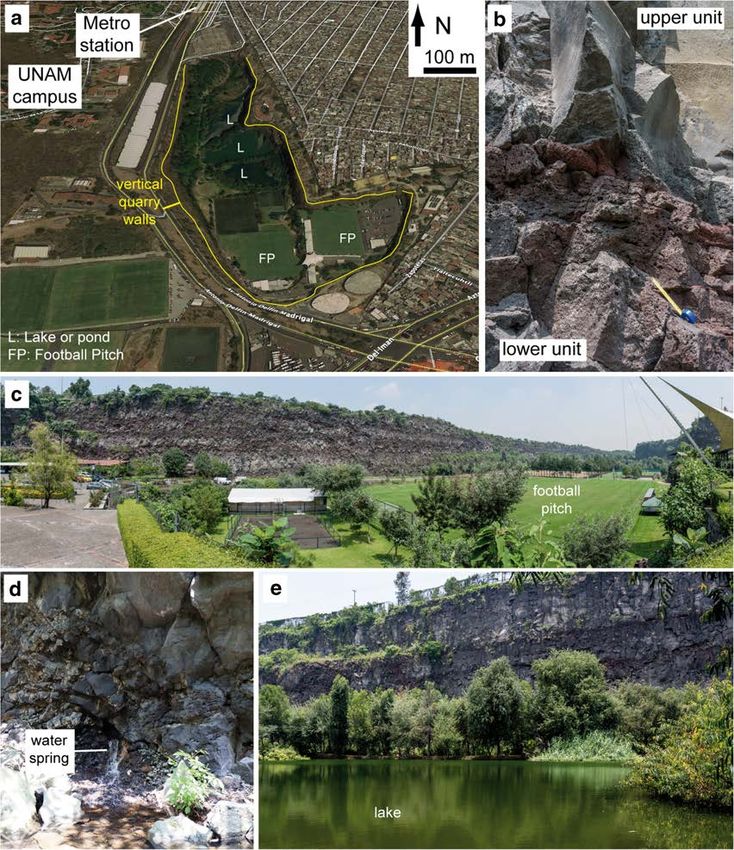
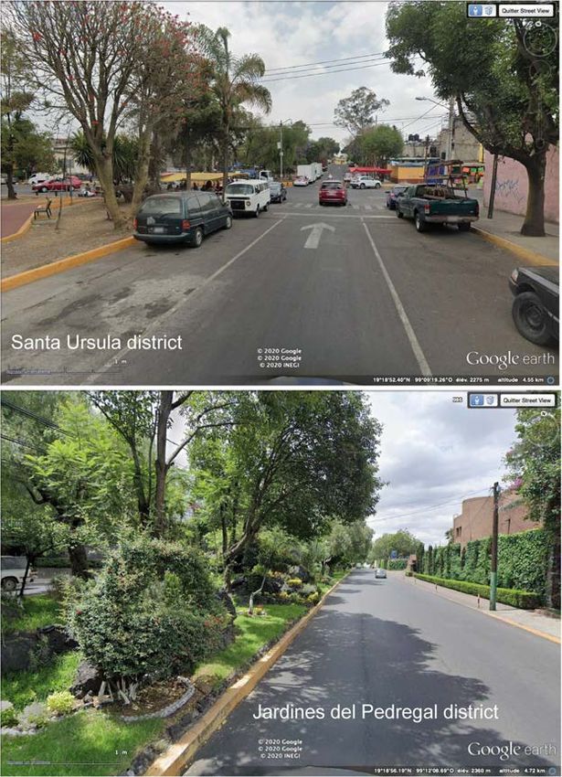
Geoheritage         (2021) 13:6                                                                         Page 3 of 27   6

Fig. 1 a Localization of the Xitle
volcano and Mexico City in the
Trans-Mexican Volcanic Belt and
associated arc-type tectonic sys-
tem. Dark filled triangles indicate
mayor stratovolcanoes along the
belt. Black filled points indicate
main cities with millions of in-
habitants. Note that most of these
are located in the volcanic belt
and hence at risks from new and
ongoing eruptions. b Localization
of Xitle volcano (yellow triangle)
and Xitle lava field (yellow poly-
gon) including the UNAM cam-
pus, in the SW corner of the
Mexico Basin host to Mexico
City. White triangles are volca-
noes of the Sierra Chichinautzin
formed during the last 15,000
years. Blue and white triangles are
stratovolcanoes. Popocatépetl is
in eruption since 1994, while the
Nevado de Toluca last erupted
10,000 years ago. Ajusco is
extinct

explosive phases. The large volume erupted (> 1 km3)          live on the lava field (Hernández-Robles 2019), most of
suggests that the eruption lasted a decade or more. The       them without knowing that they sleep on a bed of lava.
lavas form barren, rocky land with irregular topography
that was mostly left un-populated, until the central cam-
pus of the National University of Mexico (UNAM) was           Characterization of the Xitle Volcano Area:
built in 1948–1952 on the far end of the flow (Fig. 2a, b;    Geological, Environmental, and Additional
Carrillo-Trueba 1995; Salas Portugal 2006). At about the      Values
same time, the Jardines del Pedregal (gardens of the rocky
place), an exclusive residential area just west of UNAM,      Geological Processes and Volcanology
was constructed under the guidance of world-renowned
architects and artists (e.g., Rivera 1952; Pérez-Méndez       Xitle volcano is located in an area of intense and highly
2007). The urbanization of the lava continued southwards      active volcanic, tectonic, and sedimentary processes (Fig.
and towards the volcano, with the construction of housing     1). It is part of the Quaternary Sierra Chichinautzin vol-
and infrastructure for the Olympic games of 1968 (Fig.        canic field, which consists of more than 200 small volca-
2c), followed by extensive residential areas and commer-      nic edifices, most of them scoria cones and lavas (e.g.,
cial centers in the early 1970s (Fig. 2d). By now, the city   Bloomfield 1975; Martín del Pozzo 1982; Márquez et al.
has incorporated almost the entire lava field, except for a   1999; Siebe 2000; Arce et al. 2013). This volcanic field
few patches, which are under high stress (Cano-Santana        forms the central part of the active Trans-Mexican volca-
et al. 2006). The largest and best conserved of these         nic belt, a wide band that crosses Mexico east-west and
patches is the Reserva Ecológical de San Ángel or             includes stratovolcanoes, vast fields of small, monogenet-
REPSA, an ecological reserve with a core zone of              ic volcanoes, and some calderas (Fig. 1). The axial part of
171 ha and a buffer zone of 66 ha that was created in         the belt is affected by extensional forces that created a
1983 inside UNAM (http://www.repsa.unam.mx;                   series of high-altitude (> 2000 m asl) tectonic basins, in-
Zambrano et al. 2016). About 660,000 people currently         cluding the Mexico basin where the city is located (Fig.
6 Page 4 of 27 Geoheritage (2021) 13:6
Fig. 2 a Vertical aerial photo of the present location of the central part of southern peripheric road of Mexico City (Periferico sur), just after its
the UNAM campus in 1941 (FICA foundation). The location of the construction on the lavas in 1961 (provided by A. Lentz). d Vertical aerial
agricultural fields where the Olympic University stadium and the photo of the lava field to the south of the Periferico sur in 1973. Note the
Central Campus were constructed few years later is indicated. Note also road tracks of an exclusive residential area (Fuentes del Pedregal) and a
the concave shape of large quarries into the lavas that are now urbanized. mall (Perisur) in the northern part, and a more extensive popular area
The entire area is virtually unrecognizable in today’s photographs. b (Heroes de Padierna) to the southeast. The area is now entirely urbanized,
Oblique aerial photo of the first university building constructed over the except for few remaining patches including the Los Encinos area (LE),
lava field (taken from Salas Portugal 2006). c Oblique aerial photo of the the summit of Cerro Zacatépetl hill (CZ), and the Bosque de Tlalpan (BT)
1). The basins are filled by lacustrine and volcaniclastic formed by single (mono) eruptions with one cause (genetic).
sediments and were occupied by shallow endorheic lakes While scoria cones are abundant along the Trans-Mexican
that have largely disappeared due to anthropogenic activ- volcanic belt, basalts are atypical in subduction settings, and
ity. The Xitle volcano is a strong marker of this highly especially so the alkaline, Ocean Island Basalt-type erupted at
dynamic setting, as its cone was built on the border of the Xitle. This drives strong interest on this particular volcano for
graben and its lava interacted with one of the preexisting geochemical studies on the source of magmatism in this re-
lakes in the basin. gion (e.g., Straub et al. 2008).
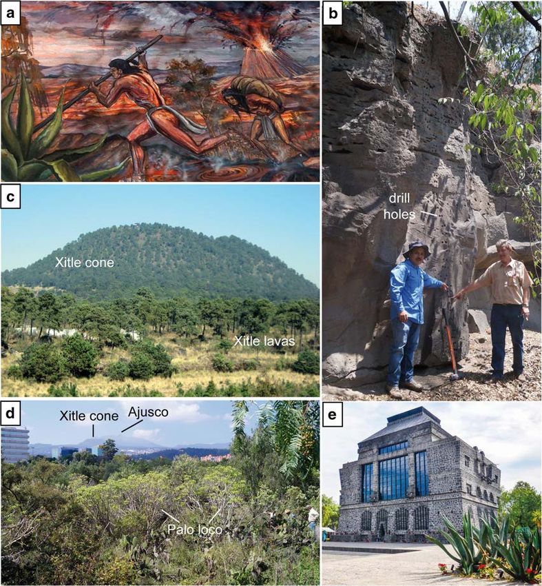
In terms of volcanology, Xitle is a fine example of a basal- Both the surface and the interior of Xitle lavas are excep-
tic scoria cone and associated lavas, which are the most com- tionally well exposed, because soils are barely formed, due to
mon volcanic structures on Earth (Fig. 3c; Wood 1980). This the young age of the basaltic lava that is hard to erode in the
type of volcano is commonly called monogenetic, as they are arid climate, and because of abundant quarrying due to the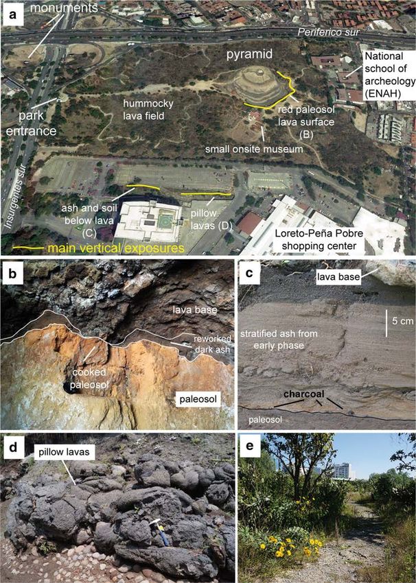
Geoheritage         (2021) 13:6                                                                                                   Page 5 of 27   6

Fig. 3 a Detail of a painting on the facade of the town hall building of      flow preserved in the Cuicuilco archaeological site. Note the Xitle cone
Tlalpán featuring pre-Hispanic people fleeing the Xitle eruption. b           and Ajusco stratovolcano in the distance. e Photograph of the Anahuacalli
Photograph of a vertical cut into a sheet lobe along the Insurgentes avenue   museum built by Diego Rivera to expose its collection of archaeologic
in UNAM. Men point to a vertical line of holes drilled for paleomagne-        pieces. It is made entirely by stones from the Xitle lava and preserves a
tism studies. c Photograph of the Xitle cone and proximal lavas covered       patch of the lava field around it
by a pine tree forest, from the south. d Photograph of the vegetated lava

expansion of Mexico City. Excavations have taken different                    however covered up when the work ends, which reduces the
forms with time. Large quarries made to extract building                      number of long-lasting exposures that can be of use for re-
stones were most prominent prior to the urbanization of the                   search or education. Early on, the outcrops resulting from the
area. Important road cuts were made when large avenues                        active quarrying have motivated the pioneering works of
(Insurgentes sur, Periferico sur) were constructed, and now                   Waitz and Wittich (1910), Wittich (1919), Schmitter (1953),
excavation is restricted to small private areas, with the aim                 and Badilla-Cruz (1977), and the more recent works of
to construct underground parking areas and to anchor struc-                   George Walker, the father of modern volcanology, who
tures against earthquakes. Most of these excavations and any                  revisited the early interpretations (Walker 1993, 2009). The
resulting exposures of the internal structure of the lava are                 many sections cut though the lavas have also permitted
6    Page 6 of 27                                                                         Geoheritage      (2021) 13:6

numerous studies on the internal magnetic properties of basal-    Hydrogeology, Water Resources, and Flood Hazards
tic lava flows (e.g., Cañon-Tapia et al. 1995, 1996). The quar-
rying is an example of how geoheritage can be promoted by         Typical for young basaltic lavas, the Xitle lavas have high
extraction, if the exposures are accessible and preserved.        hydraulic connectivity, which means that water infiltrates
                                                                  quickly and percolates in the porous rock, forming aquifers
                                                                  (Peterson 1972). For their specific topographic setting, the
Volcanic and Seismic Hazards                                      Xitle lavas act as a natural conductor of rainwater from more
                                                                  humid, higher parts of the Sierra Chichinautzin, to the drier,
Due to its tectonic setting, Mexico City is surrounded by many    lower-elevation basin where springs occur (e.g., the Pumas
young, active volcanoes and hence exposed to significant vol-     quarry site, see pictures and descriptions below). They also
canic hazards (Fig. 1, Siebe and Macías 2006). The most           serve as a buffer to floods that occur every summer rainy
obvious source of hazards is the Popocatépetl stratovolcano,      season in the basin, because the lavas soak up water. Despite
which has been in eruption since 1994 and the ash of which        the shortage of water resources in the basin and common
occasionally reaches the city. However, the dormant Nevado        interference of construction works in them, the aquifer in the
de Toluca volcano located 50 km west of the city and not          Xitle lava is poorly studied and strongly impacted by anthrop-
visible from it (Fig. 1) has deposited thick pumice layers in     ic pollution (Canteiro et al. 2019). Its existence should be
the Mexico basin, and is hence also a potential hazard that is    valued, and recognized as a means to increase the city’s
unknown to city dwellers. Another potential, yet unknown          sustainability.
hazard is that of the formation of a new monogenetic volcano
within the Sierra Chichinautzin volcanic field. This is also a    Biodiversity, Ecology, and Environment
probable impact even on Mexico City, as 14 such volcanoes
(including Xitle) have erupted during the last 15,000 years       Young basaltic lavas are a very peculiar substrate on which
(Fig. 1, Siebe et al. 2004a, 2005; Arce et al. 2015; Guilbaud     plant colonization is slow and selective, hence fostering the
et al. 2015). These volcanoes are poorly known by the public,     formation of a specific ecosystem (e.g., Del Moral and Grishin
despite the famous eruption of the Paricutin volcano in           1999). The vegetation of the Xitle lava field has been mapped
Michoacán in 1943–1952 (Luhr and Simkin 1993), being a            by Carrillo-Trueba (1995), revealing a diverse plant pattern
classic Mexican example. Xitle volcano is the most recent         that varies mostly with altitude. While high-standing areas
example of such type of volcano near the city, its products       (> 2500 m asl) are dominated by forests of pine tree, oak,
are well-exposed, and there is clear evidence for its direct      and fir (e.g., the vent area, Fig. 3c), low-altitude areas (<
impact on human settlement (see below). Hence, it is key to       2500 m asl) are mainly covered by a xeric scrub dominated
study and educate about hazards linked to monogenetic erup-       by Pittocaulon praecox that is native to Central Mexico
tions in this area.                                               (Rzedowski 1954) (e.g., the distal lavas, Fig. 3d). The
   About seismic hazards, during the past centuries,              Pittocaulon praecox is a peculiar bush locally named palo
Mexico City has been affected by large magnitude earth-           loco or mad branch, in Spanish, because it flowers in the dry
quakes that have caused serious material damage and loss          season when the rest of the vegetation is almost completely
of life (e.g., Campillo et al. 1989; Singh et al. 2018). During   dry. This vegetation type is associated with a high biodiversi-
those, the uneven distribution of the damage revealed the         ty, having almost 1820 species of all taxonomic groups rec-
crucial role of the ground firmness, the so-called site effect,   ognized, 32 of which are under protection by Mexican laws
on the intensity and magnitude of the ground shaking. This        and 54 of which are endemic to Mexico (e.g., Lot and Cano-
then resulted in the zoning of the Mexico basin in terms of       Santana 2009; Zambrano et al. 2016). The specifics of this
seismic hazards and associated construction rules (e.g.,          ecosystem strongly rely on the peculiar microtopography of
Campillo et al. 1989; Flores-Estrella et al. 2007). By being      the lava, which yields variable conditions of temperature, hu-
firm and located on the edge of the basin, Xitle lavas are a      midity, light, and organic soil depth, promoting many biolog-
safe area to live and work, and thus a testimony of the           ical adaptations in a climate alternating between clear dry and
natural factors affecting seismic hazards. It is noteworthy       rainy seasons (e.g., Castellanos-Vargas et al. 2017).
that the UNAM campus in the city hosts the Servicio
Sismológico Nacional (SSN) that is in charge of surveying         Archaeology and Radiometric Dating
the seismic activity in the whole country and informing
authorities and population (www.ssn.unam.mx). It is               Xitle has a profound significance for archaeology, as its erup-
hence a key actor for the mitigation of seismic risks.            tion destroyed the first large urban center of the Mexico basin
                                                                  (Cuicuilco). The abandonment of this site as a possible con-
                                                                  sequence of the eruption coincides with the expansion of the
                                                                  city of Teotihuacan, located further north, that became one of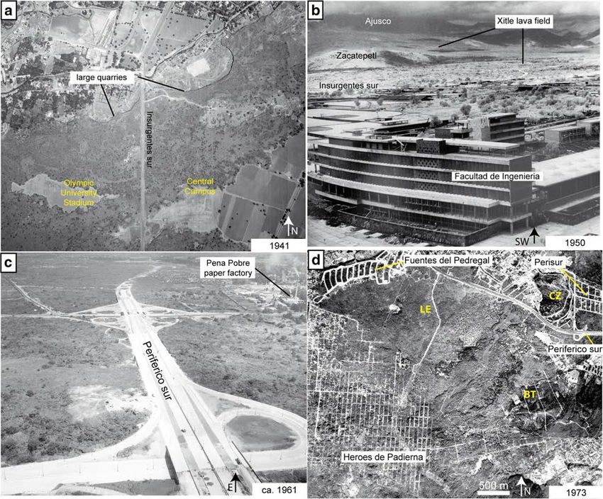
Geoheritage      (2021) 13:6                                                                                     Page 7 of 27   6

the largest urban areas in the world in the Classic period, AD       been described as “a green oasis in the middle of a mega-
350–650 (e.g., Cummings 1926; González et al. 2000; Siebe            lopolis” (Krieger 2008).
2000). Although it is yet to be validated, as there are no his-         As for architecture and cultural heritage, the Xitle lava
torical accounts and radiometric dates for the eruption are          has been used abundantly as building stone for its aesthetic
variable (see discussion in Siebe 2000), the eruption is pic-        value, resistance to erosion, and direct availability at con-
tured as responsible for a major human disaster, as portrayed        struction sites. The rocks hence form part of the architec-
in paintings located in a small museum in the Cuicuilco ar-          tural heritage of the area and contribute to its identity in-
chaeological site and on the town hall of Tlalpán, a district of     side the immense, multi-cultural megalopolis. In planning
Mexico City that was originally a village at the edge of the city    the exclusive Jardínes del Pedregal residential area that
(Fig. 3a).                                                           was constructed over the Xitle lava, Diego Rivera, proba-
   Due to its archaeological significance and excellent expo-        bly Mexico’s best known and most emblematic artist along
sure, the Xitle lava is the most dated in Mexico, both by            with his wife Frida Kahlo, highlighted the benefits of the
radiocarbon and paleomagnetic methods (e.g., Siebe 2000;             use of locally derived lava blocks that are valuable for their
Urrutia-Fucugauchi et al. 2016). The first radiocarbon age that      homogeneity, solidity, low cost, and beauty (Rivera 1952).
was acquired for this eruption (2422 ± 250 years BP) was one         The Anahuacalli museum that he built still hosts his col-
of the first ages obtained by the radiocarbon method world-          lection of pre-Hispanic objects and is a clear demonstration
wide (Arnold and Libby 1951), which shows its importance             of these precepts (Fig. 3e). These same ideas directed the
for the development of a key dating method for the Holocene          planning of the central part of the UNAM campus, which is
and Late Pleistocene. Series of holes drilled in nearly every        considered as one of the most important architectural
major vertical section in the lavas reflect also its extensive use   works of the last century, and which was declared World
for the paleomagnetism calibration that has a wide range of          Heritage site in 2007 (World Heritage Committee 2007).
applications worldwide (Fig. 3b).                                    Another example is the house called casa del Indio in the
                                                                     Coyoacán district that was built mostly by lava, by a fa-
                                                                     mous architect, Manuel Parra, for an emblematic Mexican
Arts and Aesthetics, Architecture, and Cultural                      actor (Emilio Fernández) and that can be visited. Besides
Heritage                                                             these sites, the distinct light to dark grey microvesiculated
                                                                     Xitle stone is part of many buildings, walls, stairs, and
The Xitle lava has been the source of abundant creative              platforms in the SW corner of Mexico City, which highly
work, which expresses its significance for the cultural              contributes to the aesthetics and sense of identity of this
identity of this area and makes it part of the intangible            area of the city. Nevertheless, its use is declining, and ef-
heritage. The peculiar landscape formed by the lavas (lo-            forts should be made to promote it in the construction of
cally called Pedregal de San Ángel) has inspired many                new buildings, in order to conserve the area’s identity.
artists in the past, including painters like Diego Rivera,
David Alfaro Siqueiros, Gerardo Murillo (Dr Atl) and
Joaquin Clausell, photographers (Hugo Brehme and                     Description of the Geosites
Armando Salas Portugal), sculptors (Federico Silva,
Helena Escobedo, Mathias Goeritz, Francisco Soto), poets             Palacio and Guilbaud et al. (2015) identify and describe
(e.g., Carlos Pellicer), and architects (Luis Baragan, Max           nine geosites in products from the Xitle volcano, six of
Cetto house studio). It remains an inspiration for artists           them located within UNAM’s ecological reserve. We re-
today such as Abraham Cruzvillegas, with his provocative             vised this work, redefined the areas of interest, and de-
wall of trash named Reconstrucción (2016), illustrators              scribe below four sites that present the highest scientific,
like Aslam Narvaez and Elvia Esparza, and many photog-               touristic, and educational values, and hence highest sig-
raphers who recognize the unique beauty of both the lava             nificance for valuing and conservation, and are here con-
forms and biodiversity. Several monuments of the Ruta de             sidered as primary geosites or geosites sensus stricto ac-
la amistad (route of friendship), a series of 20 sculptures          cording to Brilha (2016). We also briefly refer to other
made by renowned artists in the southern part of Mexico              sites with similar scientific values that generally have
City for the 1968 Olympic games, were strongly inspired              more limited size and poorer state of preservation but
by the lava outcrops on which they were built, and some of           can have local cultural, educational, or ecological signif-
the artistic works remain placed where the lavas are nicely          icance. These could be considered as geodiversity sites
exposed (Camarena-Berruecos 2010). The natural ecosys-               following Vereb et al. (2020). While Palacio and
tem formed over the lava and preserved in the ecological             Guilbaud et al. (2015) focused on volcanological aspects,
reserve makes UNAM’s main campus to be mentioned as                  here we adopt a more holistic assessment and incorporate
the most beautiful university in Latin America, and has              archaeological, historical, educational and biological,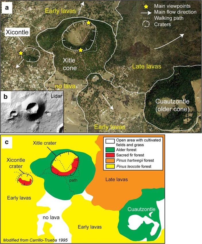
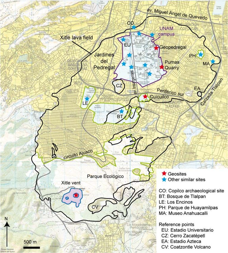
6     Page 8 of 27                                                                                             Geoheritage        (2021) 13:6

Fig. 4 General map of the Xitle cone and lava flow field with the location       correspond to places where the lava surface and its vegetation can still be
of important reference points in the city and the sites described in the text.   observed, although illegal settlements are commonly found and
Note that the topographic map used as background indicate in yellow the          deteriorate the sites
constructed areas, while “natural” areas are left in white. Most of these

ecological, and pedological considerations to highlight the                      Xitle Vent Geosite
multiple and diverse sources of interest of the sites and
underline their importance for geoconservation and                               This site is located at high altitude, on the northern flank of the
geoeducation. Descriptions are rather long and complete                          Sierra Chichinautzin range (Figs. 1 and 4). We first provide a
at the sites where these features had not been described                         short summary, and then describe the area in details, present-
before, to make a sound record and encourage further                             ing maps of the volcanological elements (Fig. 5a, b) and the
investigation. The sites are located on Fig. 4 for further                       related vegetation pattern (Fig. 5c), and showing photographs
reference. We present a quantitative assessment of the                           of the main elements (Fig. 6). As developed below, this site
values of these geosites in the following section.                               has high geodiversity which is strongly and clearly linked with
Geoheritage         (2021) 13:6                                                                                 Page 9 of 27   6

Fig. 5 Vent area geosite: maps. a
Cartography of main volcanic
elements along with the walking
paths and location of early- and
late-formed lavas on a slightly
inclined view of satellite images
draped over an elevation model
from Google Earth. b Shaded re-
lief from a 5-m resolution digital
elevation model that shows clear-
ly the shape and inner crater of the
main scoria cone and the Xicontle
spatter-lava cone. c Vegetation
cover map modified from
Carrillo-Trueba (1995) and drawn
from satellite images and field
observations. See the text for
more explanation

elements of pedodiversity and biodiversity, of significant sci-    have importance for their educational value. The position of
entific and educational interest.                                  the main cone on an elevated plateau directly south of the city
                                                                   provides panoramic views of the Mexico basin and surround-
Summary This site contains typical, proximal products of           ing volcanoes that are both aesthetic and instructive. As for
Strombolian-style basaltic activity (the weakest form of explo-    touristic values, this site is a pleasant, green area with low
sive volcanic activity) that are particularly well preserved and   atmospheric contamination that is easily accessible by city
exposed. The area also features a range in vegetation cover        dwellers. Numerous people go to this area in the weekends
and dominant tree species that are correlated with variations in   to enjoy small restaurants and outdoor activities such as horse
the parental material (lava, scoria or tephra) and the overlying   riding, hiking, and mountain biking. The walking paths are
developed soil, the orientation of the cones’ slopes (slope        easy and do not require specific equipment. For the cultural
aspect) that controls the amount of solar insulation and humid-    aspect, we have witnessed locals engaged in religious ceremo-
ity, and with the variation in altitude that allows different      nies that take place near the main crater, but this aspect needs
rainfall and humidity regimes. The dominant tree species are       to be investigated further in the future. Scientific values are
either endemic to Mexico or to Central Mexico, which is of         described in more detail below, distinguishing between volca-
biological relevance because of their associations and also        nological, biological, and pedological aspects.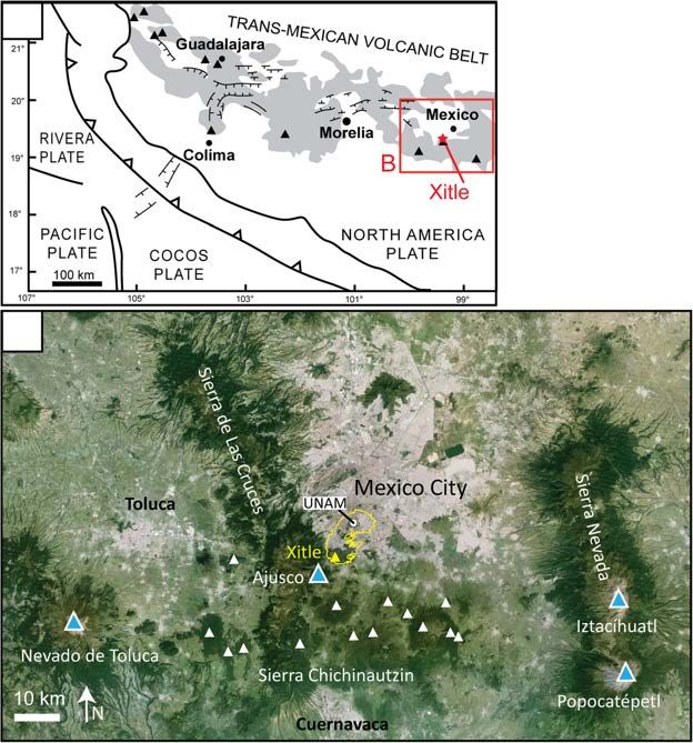
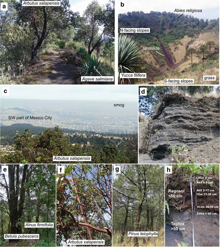
6     Page 10 of 27                                                                                         Geoheritage        (2021) 13:6

Fig. 6 Vent area geosite: pictures. a Photograph showing the path             southern part of Mexico City covered by smog. d Photograph of a ca. 1-m
surrounding the crater rim of the Xitle cone on its west side and the         deep exposure into the outermost layers of the Xitle cone that consist of
associated vegetation pattern. b Photograph taken from the south part of      layers of tephra, from ash to lapilli in size. e–g Photographs of important
the crater rim, looking north, showing the N- and S-facing crater slopes      tree species on the Xitle cone. h Photograph of the soil section described
and their contrast in vegetation and erosional pattern. c Photograph on the   in detail in Table 2 and in the text
view from the southern part of the Xitle crater rim looking N, showing the

Scientific Interests: Volcanology The vent area consists of a                 in the crust (faults), forming dikes that create a line of eruptive
scoria cone (Xitle proper) and a spatter and lava cone                        vents when intersecting the surface. The scoria cone has a
(Xicontle) that are aligned in a broad east-west direction, sug-              deep internal crater (50 m) and relatively steep (ca. 30°)
gesting a fissure (Fig. 5a, b). This type of “monogenetic”                    smooth outer slopes (Fig. 5b), which probably explain the
volcano is the most abundant on the planet, and its compo-                    name of Xitle that means belly button in the indigenous
nents are particularly well-preserved and well-exposed here.                  Nahuatl language. This morphology reflects the young age
The alignment of the Xitle and Xicontle vents highlights the                  of the cone whose original aspects have not been significantly
ascent of the magma driving the eruption along tectonic planes                affected by weathering. Small paths allow the ascent of
Geoheritage      (2021) 13:6                                                                                     Page 11 of 27   6

Xicontle and Xitle and follow their crater rim (Fig. 6a), and at    In contrast, slopes with southern, sun exposure are drier and
Xitle, descend to the bottom of the crater (Fig. 6b). The slopes    have light-colored soils (Porta et al. 2019). Hence, the south-
of the scoria cone’s crater have gullies and small-scale land-      facing hillside inside the crater with a 35° slope, has low
slides made of loose, bomb-size scoria, indicative of erosion       material accumulation, greater sun exposure, less humidity
by colluvial transport that controls the morphological evolu-       and a vegetation of grass and few trees. The result is a shallow,
tion of the crater (Fig. 6b). Viewpoints offer clear views of the   light-colored soil, because of low organic matter
crater interiors, the southern part of the Mexico Basin (com-       accumulation.
monly covered by smog), and Ajusco’s northern slopes, that
are important components of the general geological and geo-         Biology The vegetation in the vent area follows a pattern that
graphical setting (Fig. 6c). On clear days, the Popocatepetl and    matches the distribution of the volcanological elements
Iztaccihuatl stratovolcanoes that border the Mexico Basin to        (cone, crater, lava), each of them presenting distinct soil
the east can be seen. Cuts along the paths and gullies on the       types and microenvironments due to variations in altitude
slopes expose the scoria cone interior that consists of an alter-   and sun exposure (Fig. 5c). Our field observations in
nation of scoria and ash layers (Fig. 6d), as well as lava bombs    February 2020 are generally consistent with the map of
and short flows. Such deposits are typical products of mildly       Carrillo-Trueba (1995) although we noted some differences.
explosive activity that occurs at basaltic cones. In contrast,      The outer-slopes of the main cone that were mapped as an
Xicontle is made of a superposition of spatter layers and thin      alder forest by Carrillo-Trueba (1995) present a wide diver-
(< 1 m) lavas exposed in the crater, which are the products of      sity of trees that includes, in addition to alder (Alnus
lava fountaining that typically occur during weak explosive         firmifolia, Fig. 6e), birch (Betula pubescens, Fig. 6e), pine
activity along fissures. The good exposure of these products of     trees (Pinus teocote), widespread strawberry trees or
weak to mildly explosive basaltic volcanism represents an           madroño (Arbutus xalapensis, Fig. 6b, c, f), oaks (Quercus
educational asset. Of additional interest in this area is a lava    spp.), and yuccas (Yucca filifera, Fig. 6b). Vegetation inside
flow unit to the east of the main cone that has no tephra cover,    the crater is distinct from that on the outer-slopes and varies
indicating that it formed late, after the cone-forming explo-       with the slope orientation. The north-facing, slopes are cov-
sions (Fig. 5a). These lavas host a system of caves (lava tubes)    ered by a fir forest (Abies religiosa, locally named abeto or
linked to collapse structures (skylights) and some channels.        oyamel, Fig. 6b) whereas the south-facing slopes are domi-
The lava tubes are important elements of basaltic lavas that        nated by grass and small shrubs (Muhlembergia macroura,
strongly contribute to the large areas covered by these flows,      Arctostaphylos pungens, and Festuca tolucensis).
due to being very well insulated (Keszthelyi 1995). They are        Vegetation on the lavas depends mostly on the tephra cover
exposed as empty, elongated cavities when their interior is         (Fig. 6c). Tephra-free lavas (late lavas) are not cultivated and
drained, which probably occurred here at the end of the erup-       have just a few pine trees (Pinus hartwegii). In contrast, lavas
tion. These interesting aspects of the volcano are worth further    that are covered by tephra (early lavas) have a mature forest
investigation given their relevance for understanding the re-       of Pinus teocote regenerated with Pinus leiophylla (Fig. 6g),
cent, impactful volcanic activity close to Mexico City.             in addition to strawberry trees (Arbutus xalapensis), succu-
                                                                    lents (Sedum oxypetalum), and grass. An area south of the
Pedology There are interesting links between the elements of        cone that was not covered by Xitle lavas features cultivated
geodiversity of the vent area, and other factors controlling the    fields (Fig. 6c). Associated and conspicuous native vegeta-
soil formation (relief, microclimate, and organisms).               tion in the area include thistle (Cirsium ehrenbergii), tepozán
Variations in the topography in the vent area create some           (Buddleja cordata), boneset (Ageratina glabrata), and ma-
diversity in the soils. On the cone, soils are formed from re-      guey (Agave salmiana, Fig. 6a). All these plants are impor-
cently deposited unconsolidated volcanic ash and are hence          tant hosts for pollinators such as bats, nocturnal butterflies,
shallow, very stony, with incipient accumulation of organic         hummingbirds, bees, wasps, and beetles. Furthermore, the
matter and very weak structure, classifying as haplic Regosol,      different plant species live in symbiosis with different types
tephric, skeletic (humic) (Fig. 6h, Table 2, IUSS Working           of mycorrhizal fungi that are extremely important for biogeo-
Group WRB 2015). They are also highly porous and allow              chemical cycles and to maintain healthy soils, fulfilling
root growth to depths of up to 70 cm. Soil depth and color vary     many ecological functions such as carbon sequestration, nu-
with altitude, slope angle, and slope orientation. Soils are        trient translocation, soil stabilization and infiltration facili-
deeper at higher altitude because of an increase in the amount      tator (Table 1).
and size of the deposited unconsolidated tephra material.
Steeper slopes have lower material stability, lower accumula-       Other Sites with Similar Scientific Value
tion and hence less soil depth. Slope orientated to the north
causes shady, less-exposed areas to be more humid and have          Other cones of the Sierra Chichinautzin present similar char-
more trees and hence be more organic (darker colored soils).        acteristics, although the cone and lava morphology, vegetation
6 Page 12 of 27 Geoheritage (2021) 13:6
Regosol and Leptosol
pattern, and soil cover vary widely with the volcano’s age and
Regosol in patches
location (altitude, precipitation) giving a chronosequence of
and Leptosol
volcanic deposits and soils (Peña-Ramírez et al. 2009). Cones
Soil type
that present particular interest for geosite development due to
Leptosol
Regosol
Regosol
their easy access and good level of knowledge are Teuhtli
(Siebe et al. 2005; Guilbaud et al. 2015), Pelado (Lorenzo-
Merino et al. 2018), Dos Cerros (Agustín-Flores et al. 2011;
López-Valdés 2019), and Chichinautzin (Siebe et al. 2004a,
N availability and biogeochemical b; Peña-Ramírez et al. 2009; Reverchon et al. 2010).
translocation, soil aggregate
translocation, soil aggregate
Carbon sequestration, nutrient
Carbon sequestration, nutrient
Cuicuilco Geosite
stability, better infiltration
stability, better infiltration
P cycling, hydric stress, soil
Summary: This site encloses an archeological and ecological
aggregate stability
Ecological functions
park that is located at the crossing of two main avenues in south-
N and P cycling
west Mexico City and several large shopping centers (Loreto-
Pena Pobre or Cuicuilco, Periferico Sur), and hence represents a
cycling
natural green island in a dense urban area with heavy traffic and a
constant flow of people (Figs. 3d and 7a). The park has a round
pyramid that was surrounded and partly covered by Xitle lavas
(Fig. 7a), which superbly and very clearly illustrates the great
impact of a relative minor eruption on a major urban area at the
beginning of our era (González et al. 2000; Hubp et al. 2001).
Altitude (masl)
This place is also strategic for inferring the preexisting topogra-
2990–2800
2700–2500
phy, climate, and human occupation, as well as the eruption
< 2500
Associations between vegetation, soil type, altitude, and ecological functions for the Xitle volcano
3000
3000
chronology, through the study of the lava forms and the deposits
preserved below (paleosols, embedded artifacts, ash) (Fig. 7b-d;
Solleiro-Rebolledo et al. 2016). In addition, it includes a patch of
the lava field with typical landforms and associated flora and
fauna, which can be observed along pleasant walking paths
Mainly ectomycorrhiza, with arbutoid,
ericoid, and arbuscular associations
(Fig. 7e). The top platform of the pyramid provides clear views
over the southwest corner of the Mexico basin and the northern
Ecto and arbuscular mycorrhiza
Ecto, arbuscular, and arbutoide
slopes of the Sierra Chichinautzin, featuring specifically the Xitle
cone and Ajusco stratovolcano. On clear days (a rare occur-
Mainly ectomycorrhiza
rence), the Teuthli cone and the Popocateépetl stratovolcano
Mainly arbuscular
can be seen to the southeast. Of cultural and artistic significance,
Mycorrhiza type
mycorrhiza
the recently restored sculptures and monuments of the Ruta de la
Amistad (friendship route) built directly on the lava can be ob-
served on a nearby roundabout (Camarena-Berruecos 2010).
Onsite, there is a small museum that presents basic information
about the setting and archaeological findings. There is also a
painting representing the destruction of the pyramid by the
Xitle eruption.
Xerophytic scrub (Pittocaulon praecox)
strawberry trees (Arbutus xalapensis)
Archaeological Interest The rounded pyramid is one of the few
existing in Mexico and is, with the exception of small mounds
Pinus forest (Pinus teocote) and
pine scrub associated with
nearby, the only remaining building of Cuicuilco City
Abedul forest (Alnus spp.)
Fir patch (Abies religiosa)
Oak forest (Quercus spp.)
(Cummings 1926). Cuicuilco (700 BP–150 AD) is considered
the first major urban center in the Mexico Basin (Heizer and
Vegetation (species)
Bennyhoff 1958), with a peak occupation of > 20,000 inhabitants
(Sanders et al. 1979; Parsons 1989). Its great economic and po-
litical power is reflected by a majestic complex of buildings
Table 1
surrounding a temple with a conical truncated base, about 110
m in diameter and 20 m in height. There is still considerableGeoheritage (2021) 13:6 Page 13 of 27 6
Fig. 7 Cuilcuilco geosite. a
Cartography of main anthropic,
archeologic, and volcanic
elements on a slightly inclined
view of satellite images draped
over an elevation model from
Google Earth. Capital letters
indicate the location where the
subsequent pictures were taken. b
Photograph taken inside the
tunnel excavated below the lavas,
which shows the paleosol, ash
layer, and lava base. c Photograph
of a finely stratified, 17-cm-thick
ash layer found just below the la-
va, at an outcrop located next to a
building in the commercial center.
Note the tiny dark charcoal bits
found in the lowermost ash layer.
Similar fragments were dated
using radiocarbon by Siebe
(2000) to obtain the age of the
eruption. d Rounded pillow-type
lavas exposed along the ground
level of a car park in the com-
mercial center. Archeologists ob-
tained the permission in late 2018
to study this area in details be-
cause of the imminent occurrence
of major building works. e
Photograph taken at the start of
one of the pedestrian paths that
cross the lava field surrounding
the pyramid. Note the pleasant-
ness of the path provided by the
vegetation and the slightly irreg-
ular ground. One of the tall
buildings constructed along the
Periferico Sur avenue is visible in
the background, highlighting the
close vicinity of one of the busiest
roads in Mexico City
debate over whether the eruption directly caused the abandon- lava that reveal the vesicular interior of the flows and, more pecu-
ment of Cuicuilco and the migration of its population to liarly, the surface below. A tunnel excavated below the lava ex-
Teotihuacan or if both events are not connected. If it did, then poses from top to bottom: the billowy base of the lava that is proof
the eruption caused a major natural disaster (e.g., Heizer and of its emplacement as inflating pahoehoe lobes, a thin reworked
Bennyhoff 1958, 1972; Córdova et al. 1994; Siebe 2000; dark ash layer produced by early explosive activity at the cone,
Urrutia-Fucugauchi et al. 2016). and a buried soil (paleosol) that is locally indurated and trans-
formed into red brick due to the lava heat (Fig. 7b, Solleiro-
Scientific Interests: Stratigraphy and Paleoenvironment The Rebolledo et al. 2016). Such a succession very clearly shows the
archaeological excavations created numerous cuts through the chronology of events that occurred at this important site, being6 Page 14 of 27 Geoheritage (2021) 13:6
hence of scientific and educational value. This paleosol preserves several research programs, field work, and science education
important information on the paleoclimate and human occupation for school and university students of different levels. It is also
at the time of the eruption (Solleiro-Rebolledo et al. 2016). The used for photographic expositions and guided visits, as well as
ash below the lava is locally finely stratified, indicative of an local festivities that draw people from the nearby research
intense activity with rapidly succeeding strong explosions, and centers to the site and help to secure its existence (see
the basal layer contains bits of charcoal which were likely pro- Electronic Supplementary Material and http://www.geologia.
duced by the burning of vegetation along the advancing lava flow unam.mx/contenido/geopedregal). It is the first pedregal
front (Fig. 7c, Siebe 2000). South of the archaeological park, a cut remanente of the University campus with a whole program
along a car park in a commercial center exposes rounded, pillow- of restoration, which is protected by the University laws
like lava forms that suggest the existence of shallow water in that (Zambrano et al. 2019).
area at the time of the eruption (Fig. 7d; Plaza Cuicuilco in Palacio
and Guilbaud 2015). This confirms other inferences that the pre- Scientific Interests: Volcanology Lava structures in the
Hispanic city was located in a deltaic plain, at the convergence of Geopedregal site are varied and characteristics of a hummocky
river streams that flowed down the slopes of Ajusco (e.g., pahoehoe lava field like that observed in Kilauea volcano,
Córdova et al. 1994). Exposed recent pillow lavas are a rare fea- Hawaii (Hon et al. 1994). This type of lava surface morphology
ture, giving particularly high importance to this site. has not been described elsewhere in Mexico, because of the
rareness of basaltic magmas along the volcanic belt, hence being
Other Sites with Similar Scientific Value relevant for investigation and education. The main lava structures
consist on an elongated, planar sheet lobe with steep lateral mar-
The contact of the lava with the underlying ground, with a thin gins and an oval dome-shape tumulus with axial and lateral
ash layer and locally burnt paleosol with archeological arti- clefts, that are separated by a depression (lava rise pit) (Fig.
facts, can also be seen in several sites in UNAM, indicative of 8a). There are also an area with complex ropey features caused
the large area occupied by settlements that were affected by by folding of the thin and still-plastic, hot lava crust during em-
early ash from Xitle (Entrada Principal and Campo de Beisbol placement (Fig. 8b); an artificial cut that exposes the vesicular
in Palacio and Guilbaud 2015). Graves and diverse types of upper crust of the sheet lobe (Fig. 8c); an elongated cave that
objects were found in the paleosol in the Copilco quarry lo- formed by partial lateral collapse of a tumulus (Fig. 8d); and two
cated north of UNAM (Gamio 1920). However, this important connected semi-circular 1.5-m-deep cavities that probably
site that was public from the 1920s to the early 1980s formed by roof collapse of a local tube (skylights, Fig. 8e). The
(Solleiro-Rebolledo et al. 2016), is now only accessible after lava’s microtexture varies from smooth and slightly spiny to
specific request, from the offices of the National Institute of folded and show toothpaste-type texture in places. The variety
Anthropology of Mexico. in lava morphologies in this small area makes it particularly
geodiverse and gives it high didactic value.
The Geopedregal Geosite
Pedology The age of the emplaced lava is less than 1700
Summary: The ecological reserve of UNAM is the largest years, and therefore, soils are very shallow (< 4 cm) and lo-
remaining area where the distal part of the Xitle lava flow field cated only in small morphological depressions, allowing al-
and its related ecosystem can be observed. Because of the most a continuous rock surface. They contain less than 20% of
need for conservation and the high potential threats, the core fine particles and low amounts of nutrients as cations (Ca, Mg,
part of the reserve is closed to visits, but the campus encloses a K, and Na) but high organic matter, classifying as nudilithic
total of 48 ha of pedregales remanentes that are remaining Leptosol hyperskeletic distric soils (Fig. 8f, Table 2, Siebe
patches of the lava field not destroyed by infrastructure and et al. 2016). From the point of view of soil quality, one could
not covered by a thick layer of construction material waste say that site quality is poor: soil texture is coarse, causing
forming anthropogenic Technosols (SEREPSA 2008). The excessive drainage and low water holding capacity, nitrogen
Geopedregal site was created in 2012 on a ca. 3000 m2 lava retention is limited because the organic horizon is thin, but the
outcrop located on land shared by the institutes of Geology main function of these soils is infiltration and aquifer recharge.
and Geography. The site, originally used as dump, was The diversity in lava morphology in terms of slope, rough-
cleaned, restored, and converted into a small park. This ex- ness, and fracture pattern, and associated soil thickness, pro-
poses in a preserved environment the main aspects of the lava duces high biodiversity through the crucial role of microsites
morphology and related biological adaptations, ecosystem (or microhabitats) (Cano-Santana et al. 2006; Castellanos-
services such as thermal regulator, pollution buffering and Vargas et al. 2017).
pollinator corridor of bats, bumble bees and butterflies, as well The lavas around the Geopedregal have been covered with
as water capture by infiltration. It is also an aesthetically pleas- anthropic materials introduced in the early 1970s to build the
ing area (González et al. 2016). The site is used to conduct green landscaped areas of the university covered with lawn,Geoheritage (2021) 13:6 Page 15 of 27 6
Fig. 8 Geopedregal geosite. a Topographic map showing the distinct the site and present a lateral cave that is occupied by bats and other local
volcanological elements described in the text. Adapted from figure fauna. e Photograph of the jointed skylights that formed on the sheet lobe.
made by P. Leautaud. b Photograph of the corded lava features. c Note the relatively large Tepozán tree that grew from inside the cavity. f
Photograph of the vertical section across the lava that displays the Photograph of the typical type of soil that forms locally on the lava (see
typical upward increase in vesicle density and decrease in vesicle size text and Table 2 for description). g Photograph of the anthropogenic
that is observed in pahoehoe lavas and is symptomatic of a growth by Technosol soil observed on top of the lava, along the road. Note the
inflation. Note also the vegetation growing in the small fractures (cooling occurrence of man-made objects within the soil (mostly made of plastic)
joints) in the lava. d Photograph of the oval-shaped tumulus that borders and gravel
where technosols are developed that are now at least 1.5 m plant species and community consortia can develop.
thick (Fig. 8g). These two contrasting types of soil (natural vs These range from cryptobiotic saxicola crust (crust made
antropogenic) allow us to explain the ecosystem services pro- by organism growing directly on the rock) made by an
vided by the natural lava soils. association of cyanobacteria, lichens, and bryophytes, to
scrub vegetation dominated by the palo loco, agaves, and
Biodiversity Depending on the microhabitats with differen- several terrestrial orchids. Some trees species (Tepozán:
tial temperature, humidity and light conditions diverse Buddleja cordata, Fig. 8e; Encino: Quercus rugosa;6
Page 16 of 27
Table 2 Properties of soils in the Xitle catena
A. Haplic Regosol, tephric, skeletic (humic) Date: 02.02.2020
Position: Top west hillside of Xitle Volcano Parental material: Xitle cone tephra
Vegetation: Oak-Pine forest with a high arbustive and perenial coverage Described by V. Peña, H. Cotler, S. Cram
Depth (cm) Color (Munsell) Texture Structure Stones AD pH Roots In situ humidity (pF) Porosity AS Limit Horizon
2–0 litter Litter
0–2 10YR 2/2 AC Granular 25 50 Low Tephra
B. Nudilithic Leptosol hyperskeletic (distric) Date: 01.10.2017
Position: Plateau lava in the REPSA, UNAM campus Parental material: Xitle basaltic lava
Vegetation: Pittocaulon praecox shrub Described by M. P. Ortega-Larrocea
Depth (cm) Color (Munsell) Texture Structure Stones AD pH Roots In situ humidity (pF) Porosity AS Limit Horizon
1–0 litter Litter
0–1 10YR 2/2 AC Granular Low < 10%Geoheritage (2021) 13:6 Page 17 of 27 6 Fig. 9 Pumas quarry geosite. a Map of the Pumas quarry or Cantera the site that shows the largest football pitch and the quarry walls, as well Poniente. Note its location between the UNAM campus to the west, as the surrounding green areas. d Photograph of a water spring that can be and the densely populated Santo Domingo popular borrow to the east. b seen along a walking path at the base of the highest quarry wall along the Contact between two flow units exposed along the quarry walls. Note the western border of the site. e Photograph of the lake and the eastern quarry reddish (oxidized) vesicular upper crust of the lower unit and denser, wall in the background, taken from a walking path. Note the pleasant light-gray internal core of the upper unit. c Panoramic photograph of green setting and peculiar vegetation Copal: Bursera fagaroides and Bursera cuneata) grow in grows on flat surfaces exposed to abundant sunlight. skylights and deep inflation clefts. Orejas de burro The irregularity for the surface and the presence of caves (Crassulasean Echeveria gibbiflora) typically grows in also promotes significant diversity in fauna, such as local fractures and shallow inflation clefts as well as cactus mammals and insects (marsupial Tlacuache Didelphis (nopal: Opuntia tomentosa, Mammillaria magnimamma, virginiana, ringtail Cacomixtle Bassariscus astutus, ro- and the endemic Mammillaria haageana san-angelensis), dent Ratón piñonero Peromyscus gratus gratus, and the and the bat-pollinated agave Manfreda brachystachya endangered bat Leptonycteris curasoae).
You can also read