Juma Sustainable Development Reserve:
The First REDD Project In The Brazilian Amazon
←
→
Page content transcription
If your browser does not render page correctly, please read the page content below

Juma Sustainable Development Reserve: The First REDD Project In The Brazilian Amazon
Co-Founders: A Partnership with:
JUMA SUSTAINABLE DEVELOPMENT RESERVE:
    THE FIRST REDD PROJECT IN THE BRAZILIAN AMAZON

Viana, V., Cenamo, M., Ribenboim, G., Tezza, J., Pavan, M.,
2008. Juma Sustainable Development Reserve:
The First REDD Project In the Brazilian Amazon. Fundação
Amazonas Sustentável. Manaus, 2008
Special Thanks

The Juma Sustainable Development Reserve REDD Project was made possible thanks to the eco-
nomic contribution and partnership of Marriott International Inc.
To the inspiring vision of J. Willard Marriott Jr, Chairman and CEO of Marriott International, and his
entire team goes our special thanks and deepest gratitude.

            Luiz Fernando Furlan                                            Virgílio Viana
           Chairman of the Board                                          Director General
      Fundação Amazonas Sustentável                               Fundação Amazonas Sustentável
This publication was produced based on the Project Design Document (PDD) of the Juma Sustainable Development
Reserve, which is the official documentation used for the project validation on the Climate, Community and Biodiversity
Alliance (CCBA). The PDD is available for download at www.climate-standards.org

ORGANIZERS OF THIS PUBLICATION                                 STATE SECRETARIAT OF PLANNING AND ECONOMIC DE-
                                                               VELOPMENT OF AMAZONAS (SEPLAN/AM)
Prof. Virgilio Viana
Mariano Colini Cenamo                                          • Denis Minev
Gabriel Ribenboim                                                State Secretary of Planning and Economic
Antonio Roberto Ximenes                                          Development of Amazonas
Mariana Pavan                                                  • Marcelo Lima
                                                                 Executive Secretary
PROJECT TEAM AMAZONAS SUSTAINABLE FOUNDATION
(FAS)                                                          INSTITUTE FOR CONSERVATION AND SUSTAINABLE DE-
                                                               VELOPMENT OF AMAZONAS (IDESAM)
• Prof. Virgilio Viana
  Director General                                             • Mariano Colini Cenamo
• João Tezza Neto                                                Executive Secretary and Coordinator of the
  Technical-Scientific Director                                  Climate Change and
• Gabriel Ribenboim                                              Environmental Services Program
  Project Manager                                              • Mariana Nogueira Pavan
• Vanylton Santos                                                Researcher of the Climate Change Program
  Legal Counsel                                                • Gabriel Cardoso Carrero
• Raquel Luna Viggiani                                           Researcher of the Climate Change Program
  Project Assistant                                            • Rômulo Fernandes Batista
                                                                 (Independent Consultant)
STATE SECRETARIAT OF THE ENVIRONMENT AND SUS-                  • Matthew D. Quinlan
TAINABLE DEVELOPMENT OF AMAZONAS (SDS/AM)                        (Independent Consultant)
                                                               • Marina Gavaldão
• Nádia Cristina d’Avila Ferreira                                (Independent Consultant)
  State Secretary the Environment and Sustainable
  Development of Amazonas (SDS/AM)                             SCIENTIFIC COMMITTEE
• Marina Thereza Campos
  General Coordinator of the State Center on Climate           • Prof. Virgilio Viana
  Change (CECLIMA/AM)                                            Amazonas Sustainable Foundation (FAS)
• Domingos Macedo                                               Coordinator of the Committee
  General Coordinator of the State Center                      • Prof. Britaldo Soares-Filho
  for Protected Areas (CEUC/AM)                                  Federal University of Minas Gerais (UFMG)
• Francisco Higuchi                                            • Carlos Rittl
  Coordinator of Climate Research                                Independent Consultant
  and Monitoring (CECLIMA/AM)                                  • Prof. Lucio Pedroni
• Rodrigo Freire                                                 CATIE / Carbon Decisions
   Coordinator of Special Projects (CECLIMA/AM)                • Prof. Niro Higuchi
                                                                 National Institute for Amazon Research (INPA/IPCC)
                                                               • Prof. Paulo Moutinho
                                                                Institute for Environmental Research in the Amazon (IPAM)
                                                               • Prof. Philip Fearnside
                                                                 National Institute for Amazonian Research (INPA/IPCC)
                                                               • Dr. Werner Grau Neto
                                                                 Pinheiro Neto Advogados
Amazonas Sustainable Foundation

BOARD OF TRUSTEES                                            ADVISORY BOARD
The Board of Trustees is the superior deliberative author-
                                                             Responsible for advising the Board of Trustees and Directors
ity of the Amazonas Sustainable Foundation – Fundação
Amazonas Sustentável, in Portuguese – responsible for the
                                                             • José Aldemir de Oliveira
establishment of guidelines, financial management, pro-
                                                               Secretaria de Estado de Ciência e Tecnologia – SECT
grams´ approval and member assignment for the Advisory
                                                             • Eronildo Braga Bezerra
Board and Fiscal Council. The member of the FAS Board in
                                                               Secretaria de Estado de Produção Rural – SEPROR
their personal capacity participative and not as represen-
                                                             • Raimundo Valdelino Rodrigues Cavalcante
tative of then respective Institutions.
                                                               Agência de Desenvolvimento Sustentável
                                                               do Amazonas – ADS
Chairman: Luiz Fernando Furlan                               • Nádia Cristina d`Avila Ferreira
                                                               Secretaria de Estado do Meio Ambiente
BUSINESS SECTOR                                                e Desenvolvimento Sustentável – SDS
                                                             • Marcos Roberto Pinheiro
• Lirio Albino Parisotto: Vice-chairman                        WWF-BRASIL - World Wildlife Fund
  Videolar                                                   • Paulo Roberto Moutinho
• Phellipe Daou                                                Instituto de Pesquisa Ambiental da Amazônia – IPAAM
  Rede Amazônica de Rádio e Televisão                        • Mariano Colini Cenamo
• Luiz Nelson Guedes de Carvalho                               Instituto de Conservação e Desenvolvimento
  Nisa Soluções Empresariais                                   Sustentável do Amazonas – IDESAM
• Firmin Antonio                                             • Antônio Carlos da Silva
  Rede Accord                                                  Federação das Indústrias do Estado do Amazonas – FIEAM
                                                             • Carlos Edward de Carvalho Freitas
SCIENTIFIC SECTOR                                              Universidade Federal do Amazonas – UFAM
                                                             • Carlos Eduardo F. Young
• Adalberto Luiz Val                                           Universidade Federal do Rio de Janeiro – UFRJ
  Instituto Nacional de Pesquisas da Amazônia (INPA)         • Thomas E. Lovejoy
• Carlos Affonso Nobre                                         The H. John Heinz III Center for Science,
  Instituto Nacional de Pesquisas Espaciais (INPE)             Economics and Environment
• Jacques Marcovitch                                         • Adilson Vieira
  FEA/USP                                                      Instituto de Pesquisa e Desenvolvimento Amazônico – IPDA

SOCIOENVIRONMENTAL SECTOR                                    FISCAL COUNCIL

• Manoel Silva da Cunha                                      Responsible for supervising and evaluating all fiscal activities.
  Conselho Nacional dos Seringueiros – CNS
• Estevão Lemos Barreto                                      • José dos Santos da Silva Azevedo
  Coordenação das Organizações                                 Associação Comercial do Amazonas – ACA
  Indígenas e Povos do Amazonas – COIAM                      • Maurício Elíseo Martins Loureiro
• Mario César Mantovani                                        Centro da Indústria do Estado do Amazonas – CIEAM
  Fundação SOS Mata Atlântica                                • Dr. Leopoldo Péres Sobrinho
                                                               Controladoria Geral do Estado – CGE
GOVERNMENTAL SECTOR
                                                             BOARD OF DIRECTORS
• Carlos Eduardo de Souza Braga
  Amazonas State Governor
                                                             The Board of Directors is responsible for the daily management,
• Flávia Skrobot Barbosa Grosso
                                                             performing the Foundation´s strategies and programs, in atten-
  Suframa Superintendent
                                                             dance to their technical, administrative and financial aspects. Re-
• Denis Benchimol Minev
                                                             ports to the Board of Trustees and supports the Advisory Board
  Secretaria de Estado de Planejamento e
                                                             and Fiscal Council.
  Desenvolvimento Econômico – SEPLAN

                                                             Director General: Prof. Virgilio Viana
                                                             Scientific and Technical Director: João Tezza Neto
                                                             Administration & Finance Director: Luiz Cruz Villares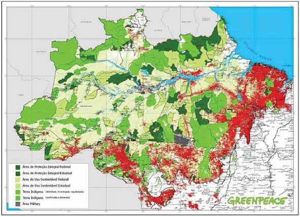
Juma Sustainable Development Reserve
INDEX

1 - EXECUTIVE SUMMARY ...................................................................................................................................... page. 10

2 - THE JUMA RESERVE ........................................................................................................................................... page. 16
     2.1 - Location ......................................................................................................................................................... page. 16
     2.2 - Communities ................................................................................................................................................ page. 17
     2.2.1 - Social Aspects ........................................................................................................................................... page. 18
     2.2.2 - Economy..................................................................................................................................................... page. 18
     2.2.3 - Private Properties .................................................................................................................................... page. 19
     2.3 - Deforestation ............................................................................................................................................... page. 20
     2.4 - Vegetation types and carbon stocks ................................................................................................... page. 22
     2.5 - Biodiversity ................................................................................................................................................... page. 28
     2.5.1 - Threats To Regional Biodiversity ........................................................................................................ page. 29

3 - TECHNICAL ASPECTS ......................................................................................................................................... page. 30
     3.1 - Baseline projections .................................................................................................................................. page. 30
     3.2 - Additionality ................................................................................................................................................. page. 34
     3.3 - Project Implementation ........................................................................................................................... page. 36
     3.3.1 - Project area and lifetime....................................................................................................................... page. 36
     3.3.2 - Net carbon benefits................................................................................................................................ page. 40
     3.3.3 - Offsite climate impacts (“leakage”)................................................................................................... page. 45
     3.3.4 - Permanence ............................................................................................................................................... page. 46
     3.3.5 - Monitoring................................................................................................................................................. page. 46
     3.3.6 - Project stakeholders............................................................................................................................... page. 48
     3.3.7 - Legal basis ................................................................................................................................................. page. 49

4 - SUSTENTABILITY STRATEGY............................................................................................................................ page. 50
     4.1 - Forest Allowance Program | Programa Bolsa Floresta ................................................................... page. 52
     4.1.1 - Family Forest Allowance ....................................................................................................................... page. 52
     4.1.2 - Forest Allowance for Associations .................................................................................................... page. 53
     4.1.3 - Social Forest Allowance ........................................................................................................................ page. 53
     4.1.4 - Income Forest Allowance ..................................................................................................................... page. 53
5 - NET BENEFITS WITH THE PROJECT ............................................................................................................... page. 54
     5.1 - Climate ........................................................................................................................................................... page. 54
     5.2 - Community ................................................................................................................................................... page. 55

6 - BIBLIOGRAPHY ..................................................................................................................................................... page. 58

ANNEXES ....................................................................................................................................................................... page. 71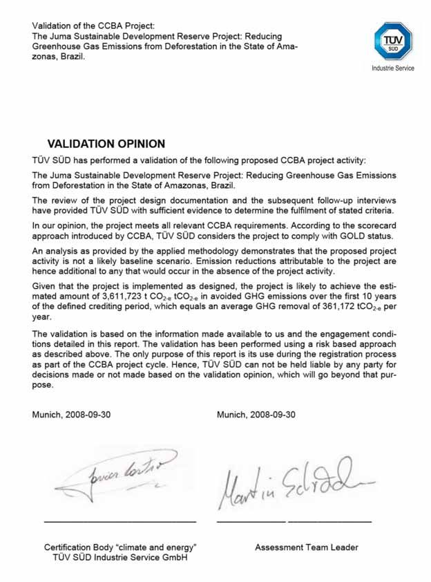
Amazonas Sustainable Foundation

             1. EXECUTIVE SUMMARY

                   The Juma Sustainable Development Reserve Project for Reducing Greenhouse Gas
             Emissions from Deforestation (“Juma RED Project”) aims to address deforestation and
             its resulting emission of greenhouse gases (GHG) in an area of the State of Amazonas,
             which is under great land use pressure. Its implementation is part of a wide strategy
             planned and initiated in 2003 by the current Government of the State of Amazonas to
             halt deforestation and promote sustainable development in Amazonas, based on giv-
             ing value to the environmental services provided by its standing forests. (Viana, 2003;
             Braga & Viana et al., 2003; Amazonas, 2002).

                  The most advanced models for simulating deforestation indicate that the rate of
             deforestation in the State of Amazonas will increase rapidly in the coming decades.
             Many experts consider the Soares-Filho et al. (2006) deforestation simulation model,
             SimAmazonia I, designed by the program “Amazon Scenarios,” and led by the Institute
             for Environmental Protection of the Amazonas State (IPAM), The Federal University of
             Minas Gerais and the Woods Hole Research Center, to be one of the most refined mod-
             els for the Amazon region. SimAmazonia I indicates that there will be a strong defor-
             estation trend in the near future, which could result in a loss of up to 30 percent of
             Amazonas’ forest cover by 2050. If concrete measures to prevent deforestation are not
             undertaken, deforestation in the protected areas of the State of Amazonas could emit
             about 3.5 billion tons of CO2 into the atmosphere.

                  According to the SimAmazonia I model, the southern region of Amazonas is one
             of the areas under higher risk of deforestation. Under the “business as usual” scenario,
             the paving of large roads (BR-319, BR-230 and AM-174) will result in the loss of large
             expanses of forest by 2050. These deforestation forecasts were strongly considered by
             the Government of Amazonas when it established the Juma Sustainable Development
             Reserve in 2006. The objectives of creating the reserve were to protect forests with
             high conservation value. The reserve seeks to protect species in risk of extinction while
             also preserving the quality of life of the hundreds of families that live in these areas.

                  The Juma RED Project begun with the establishment of a Protected Area in a region
             that would be almost completely deforested under the “business as usual” scenario if the
             current land use practices in the region continued. The Juma Reserve was created in an
             area of 589,612 hectares of Amazonian forest located near the BR-319 road and crossed
             by the AM-174 road. Its creation and effective implementation was only possible due to
             the perspective of the Government of the State of Amazonas’ plan to create a financial
             mechanism for generating a financial compensation from activities reducing emissions
             from deforestation (RED). The resources raised from the sale of these credits will permit
             the Amazonas Government to implement all of the measures necessary to control and
             monitor deforestation within the project site, enforce the law, and improve the welfare
             of local communities.
10
Juma Sustainable Development Reserve
The Juma RED Project is the first project of its kind implemented under the State
Policy on Climate Change Law (Amazonas, 2007) and the State System of Protected Ar-
eas (Amazonas, 2007). This legislation, enacted in 2007, provides the legal framework
necessary to implement RED projects in the Amazonas State.
The project expects to prevent the deforestation of about 329.483 hectares of
tropical forests that would release 189.767.027,9 tons of CO2 into the atmosphere on
the baseline scenario until 2050. It will only be possible to implement the project if
the RED financial mechanism proves viable and capable of generating the resources
necessary to cover the operational costs of implementing the activities to protect the
Juma Reserve. In addition to the climate change mitigation benefits associated with
the reduction of greenhouse gas emissions (GHG), the project expects to generate a
variety of social and environmental benefits in the project area. These benefits will
come from the following programs and groups of activities:
1. Strengthening of environmental monitoring and control by making: improvements
in the existing monitoring system managed by the local communities and by making
large investments in the work of the environmental protection infrastructure and staff
and the land titling agencies, as well as in advanced remote sensing monitoring tech-
niques. The costs of monitoring remote areas like the Juma Reserve are very expensive
because the area is very difficult to access. The RED mechanism will provide the re-
sources necessary to overcome the great deficiencies of the State’s ability to monitor
such areas.
2. Income Generation Through the Promotion of Sustainable Businesses1: Community
Income Generation Through the Promotion of Sustainable Businesses: Community or-
ganization and business training will be combined to improve the local capacity in
forest management and forest product extraction. Research and development of new
technologies will allow for innovation in the quality and types of products local com-
munities produce. Furthermore, market development activities will be undertaken to
improve market access. This combination should enhance the production of forest
products from the local communities involved in the project.
1 Marginalized communities are more likely to participate in the illegal exploitation of
natural resources. The lack of training in forest management results in the use of de-
structive practices that produce low quality products with limited market demand.
11Amazonas Sustainable Foundation
3. Community Development, Scientific Research and Education2: Education centers will be
constructed to train and transmit scientific information on conservation efforts to local
communities as well as to provide opportunities for the training of professionals spe-
cializing in biology, forest management, environmental education, etc. The engage-
ment of local communities will only be possible through the existence of solid and
active organizations, which are also necessary for organizing and strengthening local
populations..
4. Direct Payment for Environmental Services (Forest Allowance Program / “Bolsa Flo-
resta Program”): The communities will receive direct benefits for their contributions to
conservation, such as access to clean water, healthcare, information, productive ac-
tivities and other improvements in their quality of life. Furthermore, a portion of the
financial resources generated by the project will be paid to traditional communities
in the Juma Reserve for environmental services through the establishment of all four
components of the Forest Allowance Program: I) Family Forest Allowance (Bolsa Flo-
resta Familiar); II) Social Forest Allowance (Bolsa Floresta Social; III) Forest Allowance
for Association (Bolsa Floresta Associação); and IV) Income Forest Allowance (Bolsa
Floresta Renda). This translates into concrete and direct benefits for some of the most
marginalized and vulnerable populations, who are dependent on the forest for their
survival.
The “Juma RED Project” is being implemented by the Amazonas Sustainable Foun-
dation (Fundação Amazonas Sustentável, FAS) in partnership with the State Secretariat
of the Environment and Sustainable of Amazonas (Secretaria de Estado do Meio Ambi-
ente e Desenvolvimento Sustentável do Amazonas, SDS/AM) with technical assistance
from the Institute for Conservation and Sustainable Development of Amazonas (Insti-
tuto de Conservação e Desenvolvimento Sustentável do Amazonas, IDESAM).
The project implementers provide investors and donors with the guarantee that
the execution and completion of the project complie with all of the relevant legal,
governmental and regulatory structures. The project was designed through a trans-
parent process involving participatory workshops and political consultations in order
to guarantee the involvement and commitment of all the local stakeholders. Marriott
International is supporting the project implementation, with an annual investments
of US$500.000 peryear, for four years, combined with revenues from hotel guests to
offset their carbon emissions (US$1/room/day).
2
Because the influence and deforestation pressure normally comes from outside the protected areas, it is essential to help the
communities living inside these areas, especially helping the future generations of decision makers understand the importance
of Forest conservation.
12Juma Sustainable Development Reserve
On September 30th the Juma RED Project received the validation by the Standard
CCBA – Climate Community and Biodiversity Alliance – issued by the German audit
company Tüv Süd. The project earned the top score in the category Gold, the first in
the world to be included in that standard. Moreover, the Juma Reserve is the first in
Brazil and in the Americas to be certified for avoided deforestation. Until the end of
the first period of certification, in 2016, it is expected to avert the emission of at least
3,611,723 tons of CO2e. The project will end its activities in 2050, when it is likely to
have generated credits of 189,767,027 tons of CO2e.
The Brazilian Amazon is under increasing pressure. An estimated 17 percent of
the original forest coverage have already been lost. From 2000 to 2007, more than
150,000 square kilometers of the region’s forests were deforested, an area equivalent
to 3.7 percent of the total area of the Legal Amazon (INPE, 2008). In contrast, during
the same period the State of Amazonas, the largest Brazilian State (1.5 million square
kilometers), lost only 0.4% of its forested area (INPE, 2008). Historically, Amazonas has
always had the lowest deforestation rate in the Brazilian Amazon with ninety-eight
percent (98%) of the State’s original forest cover still intact. Amazonas has 157 million
square kilometers, which corresponds to 1/3 of the Brazilian Amazon.
However, over the past few years the decline in forest cover and the lack of avail-
able land resulting from the intense historic deforestation in the other states of the
Brazilian Amazon, such as Acre, Mato Grosso, Pará and Rondônia, have pulled a trend
of deforestation in the State of Amazonas. Agriculture and cattle production expan-
sion makes the large expanses of sparsely populated forests of the Amazon even more
vulnerable to deforestation. The scenario for the future is clear: if the historic trends of
deforestation in the Amazon continue, then millions of hectares in the State of Amazo-
nas will be deforested and replaced by large areas of pasture and agricultural crops.
13Amazonas Sustainable Foundation
Figure 01 – Deforestation in 2005 (based on Soares-Filho et al., 2006); (PRODES, 2006)
Figure 02 – Deforestation predicted by the Simamazonia I model for 2012
(based on Soares-Filho et al., 2006)
14Juma Sustainable Development Reserve
Figure 03 – Areas claimed by land titles In the region of the Juma Reserve
15Amazonas Sustainable Foundation
2. THE JUMA RESERVE
2.1 Location
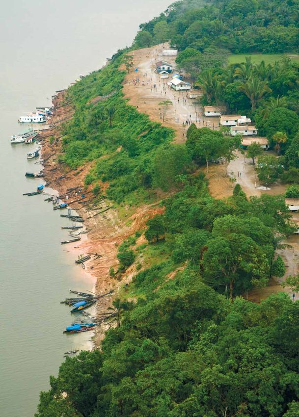
The Juma Sustainable Development Reserve RED Project is located 227.8 km south
of the city of Manaus. The urban area of the city of Novo Aripuanã is found about 10 km
East of the Northern boundary of the reserve, which runs along the right bank of the
mouth of the Aripuanã river.
The western boundary of the reserve is defined by the Mariepauá river, which
forms the frontier between the municipalities of Novo Aripuanã and Manicoré. The
southern boundary is defined by Federal land (100 km north of Transamazon Road
– BR-230), and the Eastern boundary is defined by the left bank of the Acari river
(Figure 13).
Figure 13 - Location of the Juma Reserve RED Project, showing also the BR-319, AM-174 and BR-230
roads and the municipalities of Novo Aripuanã, Manicoré and Apuí.
16Juma Sustainable Development Reserve
2.2 Communities
In accordance with the last census done in July, 2008, there are 339 families living
in 35 communities inside de Juma reserve and in its surroundings (figure 05). The pro-
cesso f identification of the communities was carried out in two occasions: (i) during
the elaboration of the study for the creation of the Juma reserve and, (ii) during the
process of registering the families for the BF Program.
Figure 05 – Communities living inside the Juma Sustainable Development Reserve
17Amazonas Sustainable Foundation
2.2.1 Social Aspects
According to the latest social inventory taken in July 2008, there is an estimated
population of 339 families living in 35 communities within the Juma Reserve and its
surrounding area (Figure 05).
All of the communities depend on subsistence agriculture (manioc and fruit pro-
duction) and extractive activities, such as fruit collection, fishing and hunting to sup-
plement their diets. Usually, subsistence practices are related to fishing and hunting,
with fish providing the major source of protein in the communities
The majority of the families living in the Juma Reserve do not have land titles or
personal documentation.
The houses are generally made of wood with roofs made of palm thatch or asbes-
tos panels. Before the project, none of the communities had a basic sanitation system
or garbage collection.
There is no organized system of health care provided by formally trained health
professionals. Basic emergency assistance is provided by community members and
is based on traditional knowledge or training provided by the local municipality. The
most common health problems and illnesses are malaria, diarrhea, verminosis, malnu-
trition, influenza and hypertension. The treatment of more serious problems requires
transportation to the hospital in the city of Novo Aripuanã in “rabetas” (wooden ca-
noes with small outboard motors).
Students of different levels compose the school classes, what makes the teacher’s
work more difficult, since she must teach all the students at the same time in the same
classroom.
2.2.2 Economy
In the preliminary study undertaken as part of the process for establishing the
Juma Reserve, more than half of the families reported their income was below the
average minimum wage in Brazil (R$ 200 to R$ 400, or US$ 118 and US$ 235, respec-
tively). A limited number of family members reported having an income higher than
three times the minimum wage (up to R$ 1200, or US$ 706)). The most important eco-
nomic activities are the extraction and sale of Brazil nuts (Bertholletia excelsa), copaí-
18Juma Sustainable Development Reserve
ba oil (Copaifera landesdorffy) and timber and the production of manioc flour (SDS,
2005). Some families have hen houses and raise chickens for domestic consumption
and others raise sheep on a small scale (SDS, 2007). The communities are extremely
dependent on the regularity of the regional boats that travel along the Aripuanã river
selling, buying and exchanging goods. Rabetas are the normal mode of transportation
for short trips.
2.2.3 Private Properties
The preliminary evaluation of private lands within the Juma Reserve undertaken
by the Amazonas Land Institute (Instituto de Terras do Amazonas, ITEAM) found that
within the project site there are approximately twenty private land title claims in a
total of 15,038 hectares (see Figure 06). A large number of those properties are not
legally recognized because they do not have complete documentation or may have
been acquired illegally and should be formally registered or appropriated by the state.
A full analysis of the legality of the documentation behind these claims has been a
high priority for the project since project implementation.
Figure 06 – Areas claimed by land titles in the region of the Juma Reserve
19Amazonas Sustainable Foundation
Since these private areas do not belong to the State of Amazonas, they are exclud-
ed from the project, and the carbon contained in their forests will not be accounted.
However, ongoing activities in these areas can impact the project area inside the re-
serve, and thus will receive special attention in the activities included in the monitor-
ing plan.
2.3 Deforestation
The deforested areas within the Juma Reserve were limited to 6,493 hectares
(1.1% of the Juma Reserve area) until June 2006 (INPE, 2008). The methodology used
to quantify deforestation within the project area using the PRODES system is described
in the Annex VIII of the Project Design Document (for more details, see full PDD at
www.fas-amazonas.org).
The actual patches of deforestation in the project area result basically from me-
dium to large scale deforestation in areas illegally occupied by land grabbers and cat-
tle ranchers along the sides of the road connecting Novo Aripuanã to Apuí (AM-174),
which crosses the project area in a North to South direction (Figure 07); and land clear-
ing for small scale agriculture practiced by the local communities.
Figure 07 – Deforested Areas in The Juma Reserve untiL 2006 (based on LandSat imagery, INPE 2008)
20Juma Sustainable Development Reserve
The project usesd a participatory process to identify and map the land use dynam-
ics of the land directly managed by the traditional populations dweling in the Juma
Reserve. This activity has already been started and will be carried out continuously as
a central part of the development process for the Reserve’s management plan.
Specifically, these activities include:
1. Specifiic modeling of the dynamics of land clearing for plantations within the
reserve;
2. Modeling of the process of forest succession after the abandonment of
agricultural fields and;
3. Fine-scale zoning of the areas currently in use and determination of the impacts of
the land use patterns on the carbon stocks of the area.
21Amazonas Sustainable Foundation
2.4 Vegetation types and carbon stocks
The Juma Reserve RED Project is covered almost entirely by well-preserved tropical
forest. According to the phyto-ecological classification established by the RADAMBRA-
SIL Project (RADAMBRASIL, 1978), there are three major forest types in the project site:
Submontane Ombrophyllous Dense Forest; Lowland Ombrophyllous Dense Forest; and
Ombrophyllous Dense Alluvial Forest.
The RADAMBRASIL Project was a extensive government program carried out be-
tween 1973 and 1983, which installed 2,719 sample plots in the Brazilian Legal Ama-
zon for biomass inventories (Figure 08). Of these plots, 13 were located inside the Juma
Project boundaries (RADAMBRASIL, 1973-1983). The measurements that were taken
in each plot to calculate the biomass of the different forest phyto-physiognomies in-
cluded all trees with a Circunference at Breast Height (CBH) greater than 100 cm (i.e., a
Diameter at Breast Height (DBH) greater than or equal to 31.83 cm).
Figure 08. Juma Reserve’s vegetation types. White circles and red dots indicating the sampled plots of
the inventory described in RADAMBRASIL (1978)
22Juma Sustainable Development Reserve
Due to the broad scale of the RADAMBRASIL classification (1:1km2), the boundar-
ies of the original vegetation classes were appropriately adjusted to the on-site condi-
tions of the project using LandSat images and a GIS guided flyover filming. It was also
decided to re-classify two of the vegetation classes to simplify the ex-ante carbon es-
timates. The Submontane Ombrophyllous Dense Forest and Lowland Ombrophyllous
Dense Forest were grouped into a new class called Dense Forest. This grouping was
made because no clear difference was detected in the vegetations during the flyover,
and because the carbon stocks presented in the literature for the two vegetation class-
es, (submontane = 186.8 tC/ha; lowland = 184.3 tC/ha) are equivalent. The corrected
map is shown in Figure 095.
Figure 09 – Vegetation classes used in the Juma RED Project
5
The methodology used to classify the vegetation is presented in Annex VI of the Juma Reserve Project Design Document (PDD),
available at www.fas-amazonas.org.
23Amazonas Sustainable Foundation
The sources used to define the carbon stocks in the vegetation classes of the proj-
ect are derived from MCT (2006) and Nogueira et al. (2008), based on the RADAMBRA-
SIL Project (1978).
Although there is consensus for using RADAMBRASIL phyto-physiognomy classifi-
cation for the Amazon forests, there exist differing opinions about the estimates for the
biomass stocks that should be used to calculate the total amount of carbon existing in
the Brazilian Amazon. Until recently, the values provided by the First Brazilian Inventory
of Anthropogenic Greenhouse Gases Emissions (Primeiro Inventário Brasileiro de Emis-
sões Antrópicas de Gases de Efeito Estufa) (MCT, 2006) were considered the most reli-
able data.
However, since the publication of the Brazilian Inventory in 2006, the scientific
community has made significant advances to improve the carbon stock estimates for
biomass and for carbon in the Amazonian forest. Among this work, it is worth men-
tioning Nogueira et al. (2005, 2006, 2007, 2008a,b, c), which inventoried 602 addition-
al trees for Central Amazonia and Southern Amazonia (Nogueira et al., 2007), and in
which details of the study area and correction procedures are described.
The estimates of Nogueira et al. (nd, p. 8) and MCT (2004, p. 23) both used the allo-
metric equation from Higuchi et al. (1998) from the Central Amazon, to calculate bole
biomass of tree datasets from the RADAMBRASIL Project (the trees inventoried had a
circumference at chest height (CCH) greater than 100 cm, or 31.7 cm of diameter at
chest height (DH)), as follows:
5 < DBH ≥ 20 cm
ln(fresh mass) = -1.754 + 2.665 × ln(diameter)
DBH > 20 cm
ln(fresh mass) = -0.151 + 2.17 × ln(diameter)
24Juma Sustainable Development Reserve
However, the carbon stocks considered in the biomass estimates of Nogueira et
al. (nd) combined allometric equations and inventoried wood volume in order to ad-
just the biomass estimates for different types of Amazonian forests. A new biomass
equation was developed from trees harvested on relatively fertile soils in the Southern
Amazon and new bole-volume equations were developed from trees in dense and
open forests. These allometric relationships were used to assess uncertainties in previ-
ous estimates of wood volume and biomass.
In the case of the usual biomass model, based on inventoried wood volume, the
study evaluated whether the factors currently used to add the bole volume of small
trees (volume expansion factor) and the crown biomass (biomass expansion factor)
are adequate for the biomass conversion. To assess the performance of the equations
developed in the study as compared to previously published models, Nogueira and
colleagues used the deviation (%) between the directly measured sum of the mass
of the trees and the mass as estimated by each of the previous equations, both for
sampled trees and as an extrapolation per hectare. Finally, all corrections were applied
to generate a new biomass map for forests in the Brazilian Amazon from the RADAM-
BRASIL plots, and the biomass stocks by forest type were calculated for each of the
nine states in the Brazilian Legal Amazon.
For the MCT (2006) biomass and carbon estimates, the sum of the carbon from all
trees was divided by the area of the sample plot. Then, a correction was applied for the
carbon content to include the trees with a DCH less than 31.7 cm, according to a Meira-
Filho personal communication of a circumference histogram. For the below ground
biomass, an expansion factor of 21% was then applied, as suggested by the authors.
Table 01 provides the different carbon stocks estimates according to the various
published sources, and comparing with the default values for tropical forests provided
by the IPCC GPG for LULUCF. The carbon pools considered for the project are the same
used by the studies of MCT (2006) and Nogueira et al. (2008), as described in Table 01:
(I) above ground live biomass, (II) dead wood, (III) litter, and (IV) belowground biomass.
25Amazonas Sustainable Foundation
Table 01 - Comparison of the different carbon stocks for above and below ground biomass in the veg-
etation types found within the Juma Reserve (by author3)
Above Ground Biomass
Below Ground Total Biomass
Live Biomass Dead Biomass Biomass Tons of C/ha**
Author Forest type
Tons of C/ha Tons of C/ ha* Tons of C/ha
Ombrophyllous Dense
127,71 15,69 29,55 172,95
Alluvial Forest
Nogueira Lowland Ombrophyllous
et al 136,09 16,72 31,49 184,30
Dense Forest
Submontane Ombrophyllous
136,39 16,76 31,56 184,71
Dense Forest
Ombrophyllous Dense
115,28 0,00 24,21 139,49
Alluvial Forest
MCT Lowland Ombrophyllous
115,28 0,00 24,21 139,49
Dense Forest
Submontane Ombrophyllous
112,21 0,00 23,56 135,77
Dense Forest
IPCC Default Value for Tropical Forests
131,00
(IPCC XXX)
* Dead biomass includes both dead wood and litter ** Except Organic Soils Carbon
Although the IPCC can be considered the most conservative data among the three
compared sources, these values underestimate the carbon stock values for the Ama-
zon forests, as they were generated through an average of different tropical forests in
many regions of the world. Thus, as Nogueira et al (2008) and MCT (2006) provide cred-
ible and “onsite specific” values for the existing types of vegetation in the project area,
they were preferred rather than the IPCC default values. As a conservative approach,
it was made a mean average from both sources to estimate the carbon stocks in the
forest classes present in the project area.
As presented earlier, the Lowland and Submontane Dense Forest classes were
grouped into a single category of carbon density, defined only as “Dense Forest.” This
value was obtained by the arithmetic mean of both values (Lowland and Submontane
carbon stocks), resulting in the final value per author. This procedure was done on both
the Nogueira and the MCT values, as shown in Table 02.
3
MCT did not include the pools litter and dead wood since it followed the methodology guidance provided by IPCC (2000), which
predicts only the consideration of aerial biomass for emissions due land use change
26Juma Sustainable Development Reserve
Table 02 – Carbon stocks estimates by Nogueira et al (2008) and MCT (200$)
for the vegetation classes inside the project boundaries
Above Ground Biomass
Below Ground Total Biomass
Live Biomass Tons Dead Biomass Biomass Tons of C/ha**
Author Forest type of C/ha Tons of C/ha* Tons of C/ha
Alluvial Forest 127,71 15,69 29,55 172,95
Nogueira
et al
Dense Forest 136,24 16,74 31,52 184,30
Alluvial Forest 115,28 0,00 24,21 139,49
MCT
Dense Forest 113,74 0,00 23,88 137,62
* Dead biomass includes both dead wood and litter ** Except Organic Soils Carbon
Afterwards, to define the final carbon stocks by vegetation types inside the Juma Proj-
ect boundaries, an arithmetic mean was calculated for each carbon estimate from the
different authors. The values are shown in Table 03.
Table 03 - Carbon stocks estimated “ex-ante” by forest
classes existent inside the Juma Project boundaries
Above Ground Biomass
Below Ground Total Biomass
Live Biomass Dead Biomass Biomass Tons of C/ha**
Forest type Tons of C/ha Tons of C/ ha* Tons of C/ha
Alluvial Forest 121,50 7,84 26,88 156,22
Dense Forest 124,99 8,37 27,70 161,06
* Dead biomass includes both dead wood and litter ** Except Organic Soils Carbon
It is important to mention that these values are “ex-ante” carbon estimates, and
will be validated and adjusted “post-facto” through the forest inventories that will be
carried out as part of the monitoring plan before the first project verification, as de-
scribed in Annex VIII of the Project Design Document (www.fas.amazonas.org).
The calculation of the carbon stocks of the Juma Reserve by vegetation type in-
side the project boundaries is presented in Table 04.
Table 04 - Total Carbon Stocks at the Juma Reserve RED Project
Carbon Stocks
Type of Forest (TC/HA) Area(Hectares) Total (Tons of C)
Alluvial Forest 156,22 3,603 562,860.66
Dense Forest 161,06 469,074 75,549,058.44
Total 472,677 76,111,919.1
27Amazonas Sustainable Foundation
2.5 Biodiversity
During the studies for the creation of the Juma reserve, rapid inventories and di-
agnostics of the biodiversity were undertaken within the Reserve. The PDD provides a
summary of these studies. Logically, with the start of the project, these inventories will
be expanded as part of the planned research program into the diverse ecosystems of
the reserve.
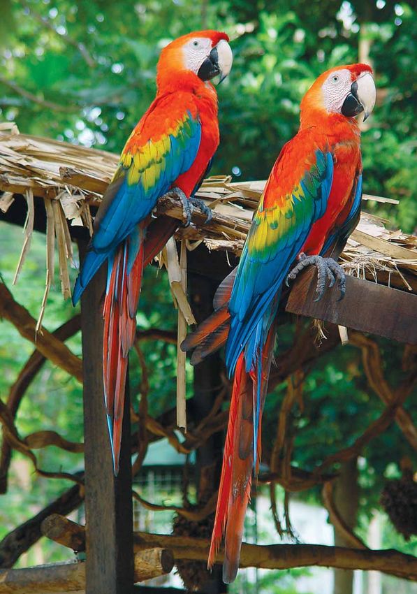
The area where the Juma Sustainable Development Reserve was created has been
identified as an extremely important area for biodiversity, especially for reptiles, am-
phibians and mammals. The region is also considered of high biodiversity importance
due to its aquatic flora and fauna (ISA et al., 1999; Capobianco et al., 2001).
The Juma Reserve region has been identified as one of the areas of greatest in-
terest for biodiversity conservation in the Amazon (SDS, 2007), and one of the least
studied areas in the Amazon (Oren & Albuquerque, 1991). One of the most relevant
characteristics of the region of the Reserve is the high degree of species richness due
to the high heterogeneity of habitats, being considered one of the world’s richest re-
gions in bird species diversity (Cohn-Haft - et al. , 2007). In recent years, numerous new
species have been described scientifically, with a high degree of endemism along the
Aripuanã riverbanks and some patches of unique vegetation (SDS, 2007).
Twenty one species of primates have been catalogued in the region, which repre-
sents one of the areas with the highest primate diversity in the world (SDS, 2007). At
least three new species of fish and three species of birds have been recently discov-
ered in the region and more than one third of the bird species (430 birds) found in Bra-
zil have been reported within the Juma Reserve’s boundaries (Cohn-Haft et al., 2007).
There is also a special part of the Juma Reserve, the riverbank of the Aripuanã river,
which is described as a high value conservation region, where a series of new species
was recently discovered and scientific cally catalogued (van Roosmalen et al., 1998;
van Roosmalen et al., 2000; van Roosmalen et al., 2002; Roosmalen & van Roosmalen,
2003; van Roosmalen et al., 2007).
28Juma Sustainable Development Reserve
The Aripuanã river has been identified as an important boundary for fauna, rep-
resenting the limit of geographical distribution of some species, especially primates
(SDS, 2007). For example, the wooly monkey (Lagothrix sp.), howler monkey (Alouatta
sp.), white-fronted capuchin (Cebus albifrons), ashy-grey titi monkey (Callicebus ciner-
ascens) and the red agouti (Dasyprocta cristata) occur exclusively on the right bank of
the Aripuanã river, while the dwarf-saki monkey (Callibella humilis) and a distinct spe-
cies of titi monkey (Callicebus bernhardi) are only found on the left bank (SDS, 2007).
These patterns coincide with those found for birds. There is a group representing
sister species that reproduced, creating a new hybrid species, but that maintained the
species or subspecies separated by the opposing banks of the Aripuanã River (Cohn-
Haft et al., 2007). This finding reinforces the theory that the river plays a role as a barrier
to the dispersion of the species and a potential factor in the evolutionary diversifica-
tion of the biota (Wallace, 1852).
During the studies for the creation of the Juma reserve, rapid inventories and di-
agnostics of the biodiversity were undertaken within the Reserve. The following items
provide a summary of these studies. Logically, with the start of the project, these in-
ventories will be expanded as part of the planned research program into the diverse
ecosystems of the Reserve.
2.5.1. Threats To Regional Biodiversity
The major imminent threats to the natural ecosystems are illegal logging, mining,
land grabbing for agriculture and cattle ranching, and overfishing. These threats have
the potential to cause great damage to the integrity of the Juma Reserve, since the Fed-
eral Government recently announced its plan to pave the roads that will directly affect
the project area (Brasil, 2007). Historically in the Brazilian Amazon, a sharp increase in
deforestation follows the paving of roads, due to the illegal logging, mining and hunt-
ing that occur as a result of the new access to natural resources that the road provides
(Nepstad et al., 2001, 2002; Laurence et al., 2004; Fearnside, 1987).
The most important driver of deforestation will be the paving of BR-319 and BR-230.
Due to the proximity of the roads to the Juma Reserve, the paving of these roads will
cause an increase in deforestation in the area of the Aripuanã River. Proper vigilance and
law enforcement can prevent the threat of deforestation from secondary roads. There-
fore, these monitoring and enforcement activities are a priority for the Juma RED Proj-
ect.
29Amazonas Sustainable Foundation
3. TECHNICAL ASPECTS
3.1 Baseline projections
Today, as in the past, 70% of the deforestation in the Amazon is still resulting from
the conversion of the forest into extensive low profit pastures. Historically this deforesta-
tion has mainly occurred in the municipalities of Pará, Mato Grosso, Rondônia, Tocantins
and Maranhão, which constitute the region of the frontier that is called the “Amazonian
arc of deforestation” (Ferreira et al., 2005; Fearnside et al., 2003) (Figure 10).
Figure 10 – Deforestation and protected areas in the brazilian Amazon. Source: Greenpeace, 2007
30Juma Sustainable Development Reserve
However, the decline in forest cover and the lack of available land due to the
dense population of the region within the “arc of deforestation” has been driving a vis-
ible tendency of migration towards the central Amazon region, principally the State of
Amazonas. The increasing rates of agricultural and cattle production are the principal
drivers of deforestation, as these activities are heading towards areas with few hu-
man occupants in the State of Amazonas. According to Stickler et al. (2007), this pres-
sure will increase as 40% of all soils in tropical regions suitable for sugar cane, palm,
pasture and soy plantation are located in the Amazon. The future scenario is clear: if
the infrastructure predicted for the State of Amazonas, such as the paving of roads, is
implemented, and if the historic trends elsewhere in the Amazon continue, the state of
Amazonas will rapidly be occupied by large expanses of pasture and agricultural fields,
and millions of hectares of forest will disappear in the process.
According to the SimAmazonia I model, the region where the Juma Projetc is lo-
cated, in the municipality of Novo Aripuanã, is extremely vulnerable to deforestation.
The paving of roads could cause the complete loss of large extensions of forest by
the year 2050 under the conventional “business as usual” scenario. The lack of roads
connecting Amazonas to other regions of Brazil is one of the major reasons for the
State’s low deforestation rates (Stone, 2007). However, the dynamics of an expanding
deforestation frontier, a low supply of timber for exploitation, and the consolidation
of agriculture and cattle production in other states in the Amazon increases migration
and, consequently, the conversion of its forests. Year after year, the areas with histori-
cally high rates of deforestation are advancing towards the State of Amazonas.
The projections of SimAmazonia I forecast eight scenarios for the entire Amazon
in 2050. One of these scenarios, the baseline scenario or conventional “business as
usual” (BAU), with low government intervention, projects deforestation trends across
the Amazon basin, and is based on historical deforestation rates, adding in the effect of
macroeconomic drivers such as the planned paving of roads, growth in cattle and agri-
cultural production, population growth and similar factors. The other seven scenarios
include an increase in governmental activity. These scenarios are more optimistic and
consider the paving of roads as also leading to a gradual increase in the government’s
influence and law enforcement in the region.
31Amazonas Sustainable Foundation
In the “business as usual” scenario, the paving of roads follows a pre-determined
program and the resulting deforestation effects are empirically estimated using data
analyzed at the municipality level from PRODES (INPE, 2008b) (Soares-Filho et al., 2006).
Specifically, the southern region of Amazonas and the municipality of Novo Aripuanã,
and the pavement of roads BR-230 (Trans-Amazonian) and BR-319 (between Manaus
and Porto Velho) will have a large role in determining the incursion of deforestation
into the Juma RED Project area.
The Juma Reserve RED Project used the BAU scenario of the simulation generated
by SimAmazonia I as the baseline scenario, extracting the Juma reserve area and pro-
viding the corresponding deforestation for each year up to 2050. Because the simula-
tion in Soares-Filho et al. (2006) was produced before the Reserve’s creation, the “busi-
ness as usual” scenario is faithful to the reality, since it does not reflect the impact of
creating the Juma Reserve, as is described in Figure 11.
Figure 11 – Forecasted deforestation in the Amazonas state by the year 2050 under the conventional
“business as usual” (bau) scenario.
Source: map is based on data obtained from the model Simamazonia I (Soares-Filho et al., 2006)
7
Deforestation data from 2006
8
Annex I of the Juma PDD shows a detailed description of the SimAmazonia I model, published in Nature by Soares-Filho et al. (2006).
The model is also available for consultation at http:// www.csr.ufmg.br/simamazonia
32Juma Sustainable Development Reserve
The SimAmazonia I projections indicate that the region where the Juma Reserve is
located is highly vulnerable to deforestation. The simulations indicate that up to 62%
(366,151 hectares) of the forest within the project area would be deforested by the
year 2050 (Figures 11 and 12). The PDD presents a detailed description and discussion
of the functioning of the SimAmazonia I, and its applicability to the project condi-
tions.
Figure 12 – Forecasted deforestation to the Juma Red Project area under different scenarios
for 2008 to 2050, compared to the conventional “business as usual” (bau) scenario
Source: map is based on data obtained from the Simamazonia I model (Soares-Filho et al., 2006)
33Amazonas Sustainable Foundation
3.2 Additionality10
Until 2002, the business as usual scenario for land use in Amazonas was character-
ized by incentives to agriculture and cattle raising, instead of forest conservation. The
deforestation rates at that time were escalating. As an example, the former Governor
of Amazonas State at the time used to distribute chainsaws in political campaigns to
promote deforestation.
In January 2003, the current Governor of Amazonas, Eduardo Braga, made an of-
ficial commitment, which was published and notarized before the beginning of his
first term (Amazonas, 2002)10. The basis of his commitment – the Green Free Trade
Zone Program (Programa Zona Franca Verde - ZFV) – was to reduce deforestation and
promote sustainable development in the State by adding value to the environmental
services in relation to the Amazonas’ forests (Braga & Viana, 2003).
The implementation of sustainable development policies that have positive impacts
on the reduction of deforestation is costly and compete for very limited governmental
resources. Given the huge demand for social program funding (human development
rates vary between 0.4 and 0.6 in Amazonas) – mainly health and education – investing
in activities directly aimed at reducing deforestation was a huge challenge with high
political risks.
Governor Braga took the risks and put in place a program for creating new State
Protected Areas as central focus at ZFV. This program generated a 133% increase in the
area of state protected areas (increased from 7.4 million ha in 2003 to 17 million ha in
2007). Deforestation was reduced by 53% (decreased from 1,585 ha/year in 2003 to 751
ha/year in 2006) (INPE, 2008). Such results and an intense process of political articula-
tion both in national and international levels were the foundation of the first proposal
of a compensation mechanism for ecosystem services provided by the State11 of Ama-
zonas.
This first proposal was presented by the Government of Amazonas at the 11th Con-
ference of the Parties of the UN Framework Convention on Climate Change (UNFCCC),
held in Montreal in 2005 (Viana et al. 2005). At the time, REDD was first discussed as
an official agenda at the COP/MOP. In November 2006, the “Amazonas Initiative” was
presented in Nairobi, at the UNFCCC’ COP 12 (Viana et al. 2006).
10
This section is based on the additionality test of the Juma RED Project, present in Annex I. This tool was adapted by Idesam (2008)
for application on REDD project activi¬ties, and was based on the original AM Tool 01: “Tool for the demonstration and assess¬ment
of additionality V05.1”, designed by the CDM Executive Board (available at: http:// cdm.unfccc.int/Reference/tools/index.html).
11
This proposal was crafted during a workshop held in Manaus - organized by the Government of Amazonas and Institute for the
Conservation and Sustainable Development of Amazonas (IDESAM) - with the presence of various Brazilian governmental institutions,
scientists, and NGOs.
34Juma Sustainable Development Reserve
The creation of the new protected areas in Amazonas was only possible with
the perspective of implementation of the financial mechanism under construction
through the activity of the Amazonas Initiative. The creation of the Juma Reserve (in
2006) and the construction of this PDD (as the first RED pilot-project of Amazonas) are
the ultimate steps of the long-term commitment started in 2003 by the Government
of Amazonas.
Therefore, for the addition assessing purposes, the start date of the activities of
RED project is 2003 – when the ZFV Program was launched. However, regarding the
definition of the project crediting period, the project start date is the date of the cre-
ation of the Juma Reserve (2006), when the project’s boundaries were clearly delim-
ited and the Juma RED Project started being implemented “on the ground”.
There was no legal requirement for the Government of Amazonas to create the Juma
Reserve, at the date it was created in 2006. The most likely scenario for the land (state
land) would be the creation of rural settlements for cattle ranching or agriculture, or its
occupation by land-grabbers. This situation can be confirmed as the business as usual
scenario for land use observed in all the other states of the Brazilian Amazon in recent
years.
The consideration of carbon finance in the decision of creating the Juma Reserve
(as well as the other protected areas newly created by the actual Government of Ama-
zonas) was always considered in the process of creating the policies and programs
of the ZFV program for forest conservation and payment for environmental services,
envisioned by the Government of Amazonas in 2003 (Braga & Viana, 2003) This had to
follow a chain of events which takes time and follow a slow and bureaucratic politic
process as: the creation of new laws, convincement of parliaments, modification of the
annual state budgets, articulation with national and international stakeholders, con-
tacts with donors and investors, etc.
At the time this process started, in 2003, there was no mechanism for compensat-
ing reduction of emissions from deforestation (REDD), nor in the perspective of the
UNFCCC negotiations, nor in the global voluntary markets, so the consideration of car-
bon finance in the process was not straightforward.
The now so called “REDD carbon benefits” were considered in the light of “payment
for environmental services” and is extensively documented in Braga & Viana (2003) and
in Amazonas (2002).
35You can also read