Yet another week of bitterly cold winter weather, with snowfall for some provinces - WeatherSA
←
→
Page content transcription
If your browser does not render page correctly, please read the page content below
Media Release

     Private Bag X097, Pretoria, 0001 • Tel: + 27 (0) 12 367 6000 • www.weathersa.co.za • USSD: *120*7297#

                                                                                                     Monday, 19 July 2021

   Yet another week of bitterly cold winter weather, with snowfall for
                            some provinces
A week of very cold temperatures is expected across the majority of South Africa from
Tuesday, 20 July 2021, lasting well into the coming weekend. The cold temperatures will be due
to a succession of cold fronts that are expected to sweep across the southern half of the
country. The first cold front will arrive over the south-western parts of the country on Monday
afternoon, followed by another, more intense, cold front on Wednesday. The latter system will
be supported by a well-defined upper-air trough, thus enhancing the overall intensity of the
weather system.
A cold front will make landfall over the south-western parts of the country on Monday afternoon, 19 July
2021. Consequently, strong north-westerly winds can be expected over the southern interior as well as
along the southern and south-eastern coastal regions. Isolated showers and rain will occur over the south-
western parts of the Western Cape province on Monday afternoon, spreading to the southern parts in the
evening. Rainfall intensity is expected to increase on Tuesday along the western part of the Cape south
coast, including the Overberg District, with the distinct possibility of localised flooding in these areas.

Light snowfalls are expected over the south-western mountain peaks on Tuesday morning, whilst bitterly
cold conditions are likely to set in over much of the interior of the Western Cape. Showers are expected to
reach the western parts of the Eastern Cape later, spreading to the Sneeuberg and Winterberg. Light
snowfall is expected in high-lying areas and mountain ranges of the western parts of the Eastern Cape,
including the Tsitsikamma, Kouga, Sneeuberg and Winterberg mountains.

A second, more intense cold front supported by an upper-air trough will affect the Cape provinces on
Wednesday through to Thursday, consolidating very cold, wet and windy conditions over the majority of
the Western and Eastern Cape interior regions. Moreover, disruptive snowfalls can be expected in many
of the higher mountain regions of the Cape provinces (refer Figure 2). An additional weather-related
impact is that, following recent significant rainfall over the south-western part of Western Cape, the

Certified for         Board Members: Ms Nana Magomola (Chairperson), Dr Phillip Dexter (Deputy Chairperson), Adv Derick
                     Block, Mr David Lefutso, Dr Mphekgo Maila, Ms Kelebogile Moroka-Mosia, Ms Sally Mudly-Padayachie, Dr
Excellence           Thuli Khumalo (DFFE Rep), Mr Itani Phaduli, Ms Feziwe Renqe. Mr Ishaam Abader (CEO).
                     Company Secretary: Ms Thandi Zide

                                                           Document Reference: CS-CMS-LETT-003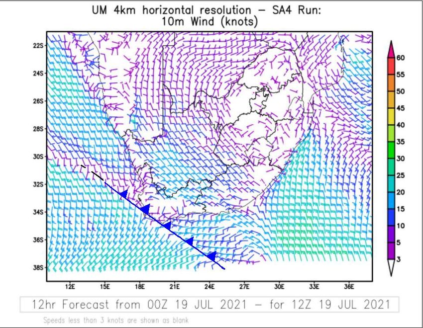
ground is still very close to saturation. Consequently, any additional rainfall over this region is likely to
lead to incidents of localised flooding. This weather-related hazard is expected to particularly impact upon
residents of informal settlements in parts of the Western Cape.

Figure 1: Predicted surface winds (knots) valid for midday, 19 July 2021, together with corresponding frontal
positions. Source: SAWS (Unified Model)

The South African Weather Service has issued the following alerts (stratified per province):

Western Cape Impacts:

A. Yellow level 2 warning for RAIN resulting in localised flooding, is expected in the Overberg and the
coastal areas of the Garden Route Districts (W. Cape) on Tuesday (20/07/2021).

B. Yellow level 2 warning for COASTAL WIND (west to south-westerly, 55-65 km/h) resulting in localised
disruptions of small harbours and ports for a short period, is expected between Cape Point and
Plettenberg Bay on Wednesday (21/07/2021).

C. Yellow level 2 warning for WAVES (6 to 8m wave heights) resulting in difficulty in navigation at sea, is
expected between Saldanha Bay and Plettenberg from Wednesday into Thursday morning (21-
22/07/2021)

                                        Medrel19July2021    Document Reference: CS-CMS-LETT-003
                                                                                                    Page 2 of 5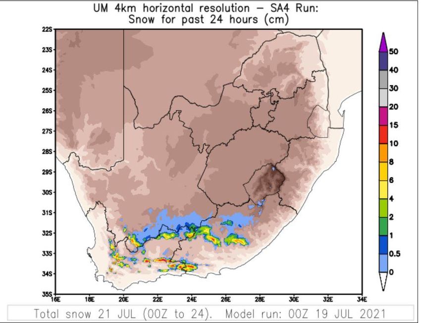
D. Yellow level 3 warning for disruptive SNOW leading to possible loss of livestock/crops, is expected over
the high lying areas of the Western Cape and southern interior of Namakwa (N. Cape) on Wednesday,
persisting through to Thursday morning (21-22/07/2021).

E. Yellow level 4 warning for RAIN leading to flooding of roads and settlements (formal/informal) is
expected over the City of Cape Town, Cape Winelands and Overberg Districts (W. Cape) on Wednesday
(21/07/2021).

Figure 2: Predicted 24-hour accumulation of snowfall (in cm), valid for 21 July 2021. Some higher elevation regions of
Western and Eastern Cape can expect 10-15cm of snowfall. Source: SAWS (Unified Model)

Eastern Cape impacts:

A. Yellow level 2 warning for Disruptive snowfall expected over Lootsberg, Wapadsberg, Penhoek,
Outeniqua, Nico Malan, Winterberg on Wednesday (21/07/2021).

B. Yellow level 2 warning for COASTAL WIND (westerly to south-westerly, 55-65 km/h) resulting in
localised disruptions of small harbours and ports for a short period, is expected between Plettenberg Bay
and East London on Wednesday (21/07/2021).

                                            Medrel19July2021     Document Reference: CS-CMS-LETT-003
                                                                                                             Page 3 of 5
C. Yellow level 2 warning for WAVES (6 to 8m wave heights) resulting in difficulty in navigation at sea, is
expected from afternoon between Plettenberg Bay and Port Alfred from Wednesday into Thursday
morning (21-22/07/2021), reaching East London in the evening.
D. Yellow level 4 warning for Disruptive snowfall expected over Lootsberg, Wapadsberg, Penhoek,
Outeniqua, Nico Malan, Winterberg passes as well as gravel road passes in the Tsitsikamma, Outeniqua
and Baviaanskloof mountains on Thursday (22/07/2021).
E. Yellow level 4 warning for RAIN leading to flooding of roads and settlements (formal/informal) is
expected along the coast and adjacent interior between Plettenberg Bay and Fish River.
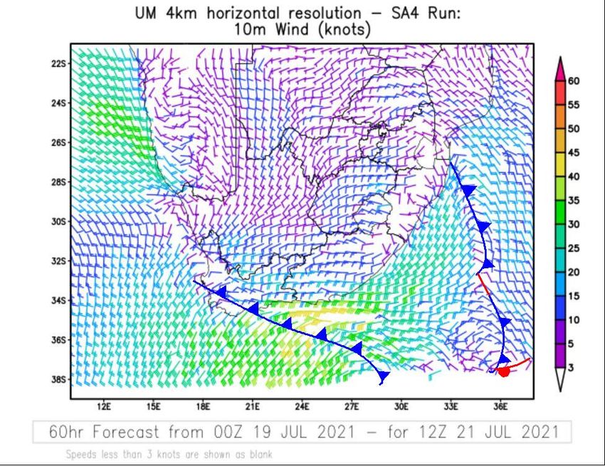
Figure 3: Predicted surface winds (knots) valid for midday, 21 July 2021, together with corresponding frontal
positions. Gale force winds, more than 34 knots can be expected along the Cape south coast (indicated by lime green
and yellow barbs). Source SAWS (Unified model)
Free state impacts:
A. Yellow level 2 warning for SNOW leading difficult driving conditions over the southern parts of the Free
State on Thursday morning (22/07/2021).
Small stock farmers and the public are therefore advised to take the necessary precautions ahead of the
expected cold snap and to ensure that livestock and pets have sufficient shelter and water.
Medrel19July2021 Document Reference: CS-CMS-LETT-003
Page 4 of 5The South African Weather Service will continue to monitor any further developments relating to this
weather system and will issue subsequent updates as required. Furthermore, the public are urged and
encouraged to regularly follow weather forecasts on television and radio. Updated information in this
regard will regularly be available at www.weathersa.co.za as well as via the SA Weather Service Twitter
account @SAWeatherServic
Compiled by: L. Pheme, E. Reyneke, S. Nake, H. Grobler, D. Van der Mescht, N. Kleinbooi and K.
Mahlangu.
Edited by: D.R. Tawana and K. Rae.
For technical and weather enquiries:
National Forecasting Centre: Tel: 012 367 6041
Media enquiries: Ms Hannelee Doubell: Manager, Communications; Tel: (012) 367 6104; Cell: 072 222 6305; E-
mail: hannelee.doubell@weathersa.co.za
USSD: Dial *120*7297#; Weather-ready, Climate-smart
Download our WeatherSMART APP free from the App store:
For Apple Smartphones: https://apps.apple.com/za/app/weathersmart/id1045032640
For Android Smartphones: https://play.google.com/store/apps/details?id=za.co.afrigis.saws.droid.activity&gl=ZA
Medrel19July2021 Document Reference: CS-CMS-LETT-003
Page 5 of 5You can also read