16 Holocene vegetation change at treeline, Cropp Valley, Southern Alps, New Zealand
←
→
Page content transcription
If your browser does not render page correctly, please read the page content below
16
    Holocene vegetation change at treeline,
    Cropp Valley, Southern Alps, New Zealand

    Matt S. McGlone
    Landcare Research, Lincoln, New Zealand
    mcglonem@landcareresearch.co.nz

    Les Basher
    Landcare Research, Nelson, New Zealand

Introduction

     New Zealand treelines have been well studied over the past few decades. Peter Wardle
carried out extensive observational and experimental studies of their ecology and suggested
that the length and warmth of summer was critical in permitting alpine trees to make sufficient
growth to survive winter (Wardle 1985a). He also showed that New Zealand treelines were
low when compared with global treelines, in particular with those of southern South America,
and that exotic Pinus contorta could grow up to 300 m above the indigenous treeline (Wardle
1985b, 2008). A later global study demonstrated that warmth of the growing season was the
one universal factor controlling position of treeline (Körner and Paulsen 2004). Both Wardle
(2008) and Körner and Paulsen (2004) suggested New Zealand alpine trees were incapable of
persisting under the cool growing season temperatures typical of treeline sites in most other
regions, a possible result of having insufficient time to evolve cool-climate adaptations.
     The 20th century trend towards warmer temperatures has intensified interest in treelines, as,
being temperature-sensitive, they should be responding to the ca. 1°C increase in mean annual
temperatures since 1900 AD. New Zealand investigations have shown there has been little or
no response (Wardle and Coleman 1992; Cullen et al. 2001), and a global synthesis (Harsch et
al. 2009) indicated that, while many treelines were rising, almost as many were static.
     Despite this interest, and the large extent of alpine terrain in New Zealand, relatively little
palaeoecological work has been reported from sites above, at, or close to treeline. In contrast,
Tasmania and southeastern Australia, in part because of Peter Kershaw’s long-standing interest,
have many intensively investigated subalpine to alpine sites and a wealth of information on

                                                                          terra australis 34
344 Matt S. McGlone and Les Basher
their treeline history (e.g. Kershaw and Strickland 1988; McKenzie 1997, 2002; Kershaw et al.
2007).
Central western districts of the Southern Alps are of great interest from both ecological
and biogeographic perspectives because they lie in the western ‘beech’ gap of the Southern Alps.
This extensive region lacks Nothofagus, arguably because of its exclusion by ice during the Last
Glacial Maximum (McGlone et al. 1996). As the vast majority of New Zealand treelines are
of Nothofagus, the history of a non-Nothofagus treeline gives a valuable additional perspective.
The work presented here consists of several pollen profiles from a west-central Southern Alps
alpine site. A summary diagram from this site with a line of accompanying text was included in
a review of New Zealand postglacial vegetation history (McGlone 1988). Given the inherent
interest in treelines, the renewed importance of understanding them in the context of climate
changes, and the paucity of palaeoecological sites at treeline in New Zealand, it was thought
appropriate to fully document the site and discuss it in the context of Australasian alpine
results.
Environmental setting
Topology and geology
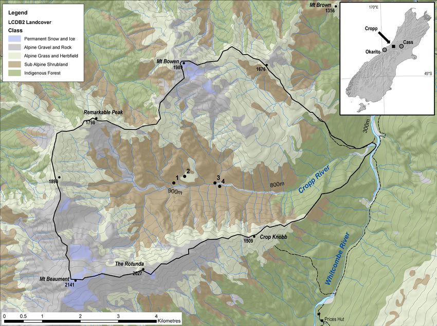
The Cropp River drains an alpine-montane basin of some 28.5 km2, centred on 43°05’S,
170°58’E, on the western flanks of the central Southern Alps. This section of the Southern
Alps has extremely high annual precipitation and high erosion rates. The basin is 8 km by
3.5 km and has a predominantly east-west orientation, ranging in elevation from 2140 m
(Mount Beaumont) to 240 m at the confluence of the Cropp and Whitcombe Rivers
(Figure 1).
Figure 1. Location map, Cropp Valley, west-central Southern Alps, New Zealand. Inset: South Island, New Zealand.
terra australis 34Holocene vegetation change at treeline, Cropp Valley, Southern Alps, New Zealand 345
The basin is composed of high-grade metamorphic rocks of green schist to amphibolite
facies. The rocks are highly fissile and commonly intensely fractured. As it lies 5-8 km southeast
of the Alpine Fault, the basin is close to the maximum uplift zone of the central Southern Alps,
with an estimated uplift rate of 12 mm a-1 (Little et al. 2005).
Regional glacial chronology indicates that the Cropp Basin was filled with ice until about
16,000 cal BP (calibrated calendar years before 1950 AD; Gellatly et al. 1988). More recent
dating of tills on the eastern side of the Southern Alps shows ice retreated after ca. 13,000
cal BP, following a late-glacial cooling during the Antarctic cold reversal between 14,900 and
12,900 cal BP (Kaplan et al. 2010). Till dated at 11,986 ± ca. 12,1000 cal BP from the middle
reaches of the basin is interpreted as a subsequent late-glacial readvance (Basher and McSaveney
1989) and gives a maximum age for the postglacial surfaces. U-shaped cirques are present at the
head of the Cropp River and its larger tributaries, but most of the glaciated landscape has been
modified by postglacial fluvial and mass movement erosion. Slopes are steep (30-60°), valley
profiles v-shaped, and stream grades steep and uneven. Regolith is thin (generally ≤2m). A wide
range of soils occurs, including yellow-brown earths, podzols, gley podozols, gley recent soils,
gley soils and organic soils. Soils are generally shallow, strongly leached and infertile.
Climate
The western front ranges of the Southern Alps are characterised by frequent, heavy rainfall
(>100 mm/day), annual precipitation in excess of 10,000 mm and persistent cloudiness. Mean
annual rainfall of the Cropp Basin is estimated at 10,800 mm a-1 (Griffiths and McSaveney
1983). Rainfall is usually well distributed throughout the year. Snow falls are frequent and may
occur at any time during the year. Snow cover persists for about three months at treeline. Mean
annual air temperature at Cropp Hut (865 m above sea level; 1982-1985; Tonkin and Basher
2001) is estimated at 5.5 ± 0.5°C, with a mean monthly range of 0-10.5°C, and a mean annual
soil temperature (at 0.5 m depth) of 6.0 ± 0.5°C. Mean daily temperature ranges from 15°C to
–5.5°C, while the absolute range is from 23.4°C to –10.1°C. Frosts may occur at any time of
the year but are most common and severe in June and July.
Vegetation
Land cover of the basin ranges from permanent snow and ice to dense montane forest, and
the high, often torrential, rainfall promotes extensive landslides and soil erosion in the upper
reaches. Vegetation descriptions of the valley follow Norton (1983) and our own observations
(Basher 1986). Below 350 m to 400 m asl, dense, mixed conifer-angiosperm forests predominate,
with tall conifers (Dacrydium cupressinum, Prumnopitys ferruginea and Podocarpus hallii) emergent
over an angiosperm canopy dominated by Weinmannia racemosa. From 400 m, the tall conifers
gradually decline and Weinmannia racemosa and Metrosideros umbellata low forest extends up
to 600 m. A Metrosideros umbellata belt with emergent Libocedrus bidwillii continues to 800 m,
grading into a Libocedrus bidwillii forest without Metrosideros umbellata that interfingers with
a low subalpine forest dominated by tall asterads (Olearia colensoi, O. ilicifolia, O. lacunosa,) and
heaths (Archeria traversii, D. longifolium, Dracophyllum traversii) and other angiosperm small
trees and shrubs (Coprosma pseudocuneata, Griselinia littoralis, Myrsine divaricata, Pseudopanax
colensoi). Tall conical emergents of Libocedrus bidwillii and lower stature Podocarpus hallii,
Phyllocladus alpinus and Halocarpus biformis occur in this association. This subalpine forest
grades into alpine shrubland between 900 m and 1000 m asl, with a range of asterad and
heath-dominated communities, Halocarpus biformis on old, leached soils, and Hoheria glabrata
on young debris soils. Alpine grasslands replace shrubland at elevations between 900 m and
1400 m asl, depending on aspect, exposure and soil depth and age. Chionochloa spp. tussock
grasses dominate well-drained sites, and species-rich communities of sedges, reeds, herbs and
terra australis 34346 Matt S. McGlone and Les Basher
prostrate shrubs and cushion plants occur on poorly drained sites. These include the creeping
podocarp Lepidothamnus laxifolium and low-growing Podocarpus nivalis.
There are numerous definitions of treeline in the literature but here we use the definition
of Körner and Paulsen (2004): “the connecting line between the uppermost groups of upright
trees of at least 3 m in height”. By this criterion, treeline in Cropp Valley lies at about 1000
m asl. The regional treeline in this section of the western Southern Alps lies between 1200 m
and 1150 m, with annual average temperatures of 5.8-6.2°C (Ellen Cieraad pers. comm. 2011).
The Cropp Valley treeline is therefore somewhat lower and colder than the regional treeline,
probably because of cold-air drainage from the high reaches of the basin.
Sites and methods
Site locations are given in Figure 1, site stratigraphies in Figure 2, and radiocarbon date
information in Table 1. All sites were sampled from exposed faces in pits or stream exposures.
Table 1. Sample locations and radiocarbon date details. Radiocarbon calibrations were calculated using the software CALIB v
5.0.1 (1) using the Southern Hemisphere Calibration dataset SHCal04 (2) (Stuiver and Reimer 1993; McCormac et al. 2004).
Cm below C Lab
14
Site Grid ref. (NZMS1) Material C age BP
14
Cal BP (median)
surface code
Site 1. Cropp Hut: J34/439903 Peat 25 1053 ± 87 908 NZ6881
895 m Peat 55 2851 ± 85 2917 NZ6878
Peat 88-90 7065 ± 90 7837 NZ6115
Site 2. Tarkus Knob: J34/444904 Peat 175 1748 ± 38 1600 NZ5367
950 m
J34/441905 Peat 160-162 7381 ± 70 8134 NZ5369
Peat 170-180 8390 ± 76 9337 NZ5368
Site 3. Steadman
J34/446902 Wood See text 10295 ± 120 12098 NZ6576
Creek: 820 m
Site 1: Cropp Hut (field sample number: X8404)
A concave basin peat has formed in the distal zone of a prominent high-level alluvial cone of
the north bank of Cropp River slightly upstream of the site of the former Cropp Hut (destroyed
by a debris flow). The site has an elevation of 895 m and is on a forest-free subalpine valley floor.
The plant communities of the general area are grassland (Chionochloa pallens and C. rubra) or
grassland-low shrub on gently sloping surfaces, while steeply sloping surfaces are covered with
subalpine scrub (Coprosma spp., Dracophyllum uniflorum, Olearia lacunosa, Phyllocladus alpinus,
Podocarpus nivalis, Senecio bennettii) and forest (Archeria traversii, Dracophyllum longifolium,
Libocedrus bidwillii, Halocarpus biformis). The peat surface is covered with Chionochloa rubra,
Carpha alpina, Celmisia glandulosa, Donatia novae-zelandiae and Oreobolus pectinatus, and with
substantial stands of the creeping podocarp, Lepidothamnus laxifolium. Ten samples were taken
for pollen analysis and pollen results are given in Figures 3a and b.
Site 2: Tarkus Knob (field sample number X8207)
Opposite the former Cropp Hut is a prominent ice-smoothed bedrock promontory
informally named Tarkus Knob (elevation at site: 950 m). A hollow along the northern margin
of this feature has been in-filled by alluvium which contains two buried peat layers and is capped
by a peaty soil. Three radiocarbon-dated samples for pollen analysis have been taken from two
exposures along the hollow (Figure 2). The present vegetation is Chionochloa rubra grassland-
cushion bog (Carpha alpina, Celmisia glandulosa, Donatia novae-zelandiae, Lepidothamnus
terra australis 34Holocene vegetation change at treeline, Cropp Valley, Southern Alps, New Zealand 347
laxifolium, Schoenus pauciflorus). Surrounding vegetation on well-drained slopes is as described
for the Cropp Hut site.
Site 3: Terminal moraine, Steadman Creek (field sample X8512)
This site (grid reference NZMS2690 J34/446902; altitude 820 m) is described in Basher
and McSaveney (1989). A 30-40 m high terrace of the Cropp River consists of angular to
sub-rounded boulders of schist, some with surface striations, in a sandy matrix. Decomposed
twigs and logs (up to 20 cm in diameter) were found tightly embedded in a matrix of angular
clasts towards the base of the section just above the bed of the river. A piece of wood was dated
(10,295 ± 120 BP) and the matrix surrounding the wood sampled for pollen analysis.
Site 4: Surface sample sites (field samples X8621a, b and c)
Surface samples were taken from the surface of the Tarkus and Cropp Hut sites and are
included as the upper levels in those pollen diagrams. A further surface sample was taken as far
down the valley as could be reached on foot, at the confluence of the Cropp River and Reckless
Figure 2. Site stratigraphies, Cropp Basin. Conventional radiocarbon ages in text boxes. The two Tarkus Knob exposures are less
than 100 m apart. Note change of scale between Sites 1 and 2 and Site 3.
Torrent at an altitude of 820 m. The site was a patch of wet Chionochloa rubra grassland within
subalpine scrub approximately 1.5 km from tall montane forest.
Pollen and spore analysis followed standard extraction procedures (dehumification in 10%
KOH, digestion in 40% HF, followed by acetolysis and mounting in glycerine jelly for light
microscope examination). A terrestrial pollen sum of >250 grains was used and results are
presented as a percentage of the terrestrial pollen sum.
Results and discussion
Modern pollen representation (see Figures 3 and 4)
Alpine and subalpine sites derive a large proportion of their pollen rain from wind-
terra australis 34348 Matt S. McGlone and Les Basher pollinated trees in lower altitude forests (Moar 1970; McGlone 1982; Pocknall 1982). The two uppermost sites sampled from subalpine grasslands derive ca. 35% of their pollen rain from lowland tree podocarps (Dacrycarpus dacrydioides, Dacrydium cupressinum, Prumnopitys ferruginea, P. taxifolia), whereas the lower surface sample site (Site 4, Reckless Torrent), in dense, low subalpine forest, derives only 21% of its pollen from that source. Metrosideros and Weinmannia, the primary canopy species of the high montane forest in the lower reaches of the basin, make up
Holocene vegetation change at treeline, Cropp Valley, Southern Alps, New Zealand

                     Figure 3a. Cropp Hut (Site 1). Percentage pollen and spore diagram: trees and tree ferns. Pollen sum: dryland trees, shrubs and herbs.
                                                                                                                                                              349

terra australis 34
350
terra australis 34
Matt S. McGlone and Les Basher
Figure 3b. Cropp Hut (Site 1). Percentage pollen and spore diagram: shrubs, herbs, fern and fern allies. Pollen sum: dryland trees, shrubs and herbs.Holocene vegetation change at treeline, Cropp Valley, Southern Alps, New Zealand
Figure 4. Surface samples: Reckless Torrent, (820 m); Tarkus Knob (950 m). Three dated peat samples: Tarkus Knob (Site 2) buried peats; Steadman Till (Site 3), silt associated with Hoheria wood fragments.
Percentage pollen and spore diagram (major types only). Pollen sum: dryland trees, shrubs and herbs.
351
terra australis 34352 Matt S. McGlone and Les Basher
close, and they can be for most purposes treated as a single record. To get a generalised view
of changes, a composite diagram for the arboreal pollen has been constructed from the Cropp
Hut, Tarkus Knob and Steadman sequences (Figure 5).
Local vegetation cover appears to have been remarkably uniform throughout the Holocene.
Grass pollen, dominated by Chionochloa, asterads, Coprosma Dracophyllum, Myrsine, and sedges
and alpine herbs are consistently present at levels suggesting little or no change in the local
vegetation structure from the current day (Figures 3 and 4).
The oldest sample (Tarkus Knob site; 9337 cal BP) is ca. 2500 years younger than the till.
Independent confirmation of the age of this sample is provided by the trace levels of Nothofagus
versus the 1-5% levels for those younger than 9000 cal BP. Nothofagus became the dominant
forest cover between 8200 and 7500 cal BP in the Cass Basin, 70 km to the east (McGlone et
al. 2004), and this is the only likely source for this pollen type. The basal sample from the Cropp
Hut peat section is younger than 8000 cal BP and has a significant Nothofagus representation.
The contribution of lowland conifer pollen rose from 13% to 20-25% by 7500 cal BP
and reached present day levels of 30-40% by 6000 cal BP (Figure 5). High-altitude montane
Figure 5. Summary composite
percentage pollen diagram (Cropp,
Tarkus, Steadman). Lowland pollen
types: Dacrycarpus dacrydioides,
Dacrydium cupressinum and
Prumnopitys spp. Upland pollen
types: Libocedrus, Phyllocladus,
Podocarpus, Halocarpus,
Metrosideros, Weinmannia and
Quintinia. Note: lowland pollen
types are those from emergent
wind-pollinated trees that
dominate the lowlands; the upland
types are those that are known to
occur either near the Cropp sites
or in the upper montane forest
(regardless of whether they also
occur further downslope).
terra australis 34Holocene vegetation change at treeline, Cropp Valley, Southern Alps, New Zealand 353
forest types expanded from 8% to 12% between 9500 and 4000 cal BP, but did not reach
current levels of 18% until 2400 cal BP, which is when Libocedrus bidwillii became abundant
within the basin. Tree-fern spores are dominated by Cyathea smithii type (which includes the
short subalpine C. colensoi) at levels which suggest wind dispersal from montane forests but its
percentage representation does not change in the course of the Holocene.
Quintinia is the last of the montane forest species to be registered at the site (between
1600 and 900 cal BP). This canopy tree, characteristic of infertile soils in central Westland, is
confined to scattered patches in the south of the district, and does not occur in south Westland.
Wardle (1988) suggested that its distribution reflects a slow movement south from refugia in
north Westland at the end of the last glaciation. However, it was present at Bell Hill, north
Westland, before 10,400 cal BP (Moar 1971), but even there did not become abundant until ca.
3500 cal BP (Pocknall 1980). A 7000-year migration lag for local spread seems improbable. It
is far more likely that Quintinia was present throughout its current range at the end of the Last
Glacial Maximum, as suggested by its trace occurrences then at Okarito Pakihi (Newnham
et al. 2007), but remained uncommon until some aspect of the climate or soils became more
favourable for the tree in the course of the late Holocene.
Climate inferences
As discussed in regard to Quintinia, there is no reason to suspect any of the dominant tree
species were affected by migration lags: Weinmannia, Metrosideros, Quintinia and Libocedrus
have small, wind-dispersed seeds and the podocarp trees have bird-dispersed fleshy fruits.
While soil requirements may have been a constraint for some species, under the mild, high-
rainfall environment of Cropp Basin soils mature and become podozolized extraordinarily
quickly, and landslides caused by heavy rain or earthquakes are a constant source of rejuvenated
surfaces within the basin (Tonkin and Basher 2001). We therefore argue that the most probable
explanation for the Holocene vegetation changes is the direct or indirect consequences of
changing climate. Given that the Cropp Basin is directly in the path of the rain-bearing
westerlies and has an enormous surplus of well-distributed precipitation far beyond the growth
requirements of the vegetation, it further seems unlikely that changes in rainfall would have
major effects on the vegetation cover. For that reason, we focus on changes in temperature and
seasonality.
A marine-core alkenone sea-surface temperature record 200 km west of the Cropp Basin
shows that temperatures peaked in the later late glacial, and were about 1.5°C warmer than
present at 12,000 cal BP (Barrows et al. 2007). Pollen-based transfer functions show mean
annual temperatures in South Island sites to have been warmer than now from about 12,000
cal BP (Wilmshurst et al. 2007). The occurrence of tree-sized Hoheria glabrata high within the
Cropp catchment at 12,000 cal BP, close to its upper limit, implies that temperatures during
the growing season were within 1°C of those of the present. Warmer than present climates in
the Cropp Basin by 12,000 cal BP therefore seem highly probable.
Nevertheless, some observations do not fit a scenario of summer temperatures at or above
current values. In the cloudy, high-precipitation, mild climates of the western flank of the
Southern Alps, winter cold is not a significant factor except in valley bottoms exposed to cold-
air drainage (Leathwick et al. 2003). It follows that regional alpine treelines are controlled
by growing-season warmth, as demonstrated by Körner and Paulsen (2004). If summer
temperatures were 1.5°C warmer than now, vegetation zones should have been some 250 m
higher and the upper limit to closed montane forest at ca. 850-1000 m asl. Forest would have
surrounded the Cropp sites. The absence of montane forest trees, and conifers in particular,
from the catchment in the early Holocene demonstrates this did not happen. New Zealand
glaciers in the central Southern Alps are much more responsive to summer ablation than
terra australis 34354 Matt S. McGlone and Les Basher
winter precipitation (Anderson and Mackintosh 2006). The fact that a glacier advanced beyond
Holocene limits to fill the upper Cropp Valley and produce the Cropp till is therefore also
incompatible with summer temperatures warmer than those of the present.
Cool summers but higher than present mean annual temperatures necessarily imply
much warmer and shorter winters. In temperate latitudes, warm winters are important in the
lowlands as they permit frost-sensitive species to flourish. In contrast, at treeline, warm winters
are largely irrelevant or even detrimental, as warm temperatures may break dormancy and
increase frost. Cool summers and warm winters create an intensely oceanic environment which
is understood to further limit tree growth through restricting photosynthesis in summer and
increasing metabolic energy expenditure in winter (Stevens and Fox 1991; Crawford 2000).
Tall podocarps were less common than now during this intensely oceanic phase in the nearby
lowlands at Okarito (Newnham et al. 2007) and it is possible that they were also restricted
by cool summers. We conclude that in the late glacial and early Holocene, a warm-winter/
cool-summer regime depressed altitudinal forest zones and may have had a disproportionate
influence on tall conifer trees.
The Holocene vegetation sequence within the Cropp Valley (Figure 5) is best interpreted as
a response to steady increases in summer temperature. By 8200 cal BP, upper montane forests
were present in the lower reaches of the valley. By 2500 cal BP, Libocedrus bidwillii had occupied
the upper part of valley, and lowland-forest pollen rain peaked about the same time, suggesting
that upslope movement of forest zones had not reached current altitudes until then.
Other New Zealand sites near treeline or in montane settings support the scenario that
summer temperatures have been rising in the course of the Holocene. Pollen and macrofossil
evidence from subantarctic Auckland and Campbell Islands indicates that forest did not reach
current extent until 6000 cal BP, and may have continued to extend upslope into the late
Holocene (McGlone 2002; McGlone et al. 2010). In the Garvie Mountains (Central Otago),
high-altitude grassland was abruptly replaced by coniferous forest at 8300 cal BP (McGlone
et al. 1995). Pollen sites close to treeline in northwest Nelson suggest late-Holocene spread of
subalpine Nothofagus forest into low woody vegetation and grassland (Shulmeister et al. 2003).
In the North Island, in an altitudinal sequence of organic soil pollen sites across treeline (1140-
1470 m asl) on the isolated massif of Mount Hauhungatahi, Tongariro, low conifer forest rose
to dominance at ca. 9700 cal BP, but the current tall Nothofagus-Libocedrus forest spread only
from ca. 8000 cal BP, and was not dominant until several thousand years later (Horrocks and
Ogden 2000).
A forest ecosystem process model has been used in inverse mode to explore early Holocene
climate scenarios based on pollen and macrofossil data from Cass, an intermontane site 70
km east of the Cropp Valley at 600 m altitude (McGlone et al. 2011). Best fit between early
Holocene vegetation and climate was obtained when summers were no warmer than present
but winters substantially warmer. If early Holocene summers were set at 0.5°C cooler than
present, and compensated for by much warmer winters to achieve an overall warmer climate
(+1.5°C), suitable matches could also be made. Annual ocean-surface warmth and terrestrial
summer cooling in the early Holocene can thus be reconciled.
The mountain ranges of Tasmania and the southeastern coast between 43°S and 30°S
provide the closest comparable sites in Australia to Cropp Valley. Changes in Australian upland
regions are complicated by major alterations in rainfall patterns which result in asynchronous
vegetation change between sites (Donders et al. 2007). Nevertheless, there is agreement that
summer temperatures and forest cover peaked in the mid Holocene, as early recognised by
Kershaw (1988). At the northern edge of the temperate forest zone in New South Wales, at
high-altitude (1200-1500 m asl) sites on Barrington Top, current forest was established by
10,000 cal BP and vegetation typical of warmer and moister conditions was widespread over
terra australis 34Holocene vegetation change at treeline, Cropp Valley, Southern Alps, New Zealand 355
the plateau between 7500 and 4000 years ago (Dodson et al. 1986). In Kosciuszko National
Park in New South Wales, sites at treeline had grassy alpine herbfields until ca. 12,500 cal BP
and Eucalyptus increased to form similar communities to those at current treeline by 7500
cal BP. Subalpine woody communities reached maximum development between 6000 and
3000 cal BP (Martin 1986, 1999). It is possible that drier conditions earlier in the Holocene
may have delayed this maximum. In south-central Victoria, forest reached current levels at
several high-altitude sites after 11,500 cal BP (McKenzie 1997, 2002; Kershaw et al. 2007), but
wet Eucalpytus forests and Nothofagus did not achieve maximum extent until ca. 7000 cal BP
(McKenzie 2002). Changes after ca. 4500 cal BP are complicated by the onset of ENSO and
changing precipitation, but the decline in moisture-loving Nothofagus may have resulted from
the transpiration stress of increasing summer temperatures. In Tasmania, maximum treeline
altitude and warmest growing-season temperatures appear to have been achieved by 7000 cal
BP (Anker et al. 2001; Fletcher and Thomas 2007).
In summary, Australian results are consistent with those from the Cropp Valley in that they
show treelines were lower than now before 11,500 cal BP and current treelines mostly formed
only after 7000 cal BP.
Schaefer et al. (2009) note that Holocene glacier advances in the central Southern Alps
of New Zealand diminish in volume towards the present. They suggest this is largely due to
increased summer ablation, consistent with our claim that treelines have risen and summers
warmed in the course of the Holocene. It follows then that ocean-surface temperatures,
which fall during the mid-to-late Holocene as treelines rise (Barrows et al. 2007), must reflect
substantial winter cooling.
Conclusions
The latter part of the late glacial and early Holocene in New Zealand was characterised
by low treelines relative to the present. In the upper Cropp Valley, although shrubs and small
trees extended up to current treeline, the current montane-alpine forest was absent, including
the conifer Libocedrus. Similar patterns of change are seen at near-treeline sites throughout
New Zealand, usually involving the late spread of Nothofagus forest into early Holocene
tall shrubland. We conclude that highly oceanic environments during the late glacial-early
Holocene period, characterised by warm winters and cool summers, disproportionately affected
trees in the montane to alpine zones. There is a great deal of similarity in timing between the
New Zealand montane-alpine vegetation sequences over the late glacial and Holocene, and
those of the mountainous areas of Tasmania and southeastern Australia. This probably reflects
a common response to a hemispheric temperature trend. Although increasing precipitation
after a drier early Holocene is often suggested as a contributory factor to changing treelines at
Australian sites, this is far less likely to have been an issue at New Zealand alpine sites.
We suggest that during the latter half of the late glacial and the early Holocene, cool
summers, warm winters and generally drier than present conditions prevailed in southeastern
Australia and New Zealand. Summers shortened but became warmer, while winters lengthened
and cooled in the course of the Holocene. As a consequence, apparently contradictory trends
emerged in the mid-to-late Holocene: lowland forests changed character, losing frost-sensitive
components as winters became cooler, while alpine trees began to replace previous low-
growing shrublands in response to warmer summers. The decline from peak summer warmth
in montane-alpine regions noted in Australia after 5000-4000 cal BP is not as obvious in New
Zealand records.
terra australis 34356 Matt S. McGlone and Les Basher
Acknowledgements
We thank Neville Moar and Janet Wilmshurst for their comments on a draft of the
manuscript, and Rewi Newnham and Geoffrey Hope for their reviews. MSM would also like
to record his gratitude to Peter Kershaw for his encouragement and support over many years.
References
Anderson, B. and Mackintosh, A. 2006. Temperature change is the major driver of late-glacial
and Holocene glacier fluctuations in New Zealand. Geology 34:21-124.
Anker, S.A., Colhoun, E.A., Barton, C.E., Peterson, M. and Barbetti, M. 2001. Holocene
vegetation and paleoclimatic and paleomagnetic history from Lake Johnston, Tasmania.
Quaternary Research 56:264-274.
Barrows, T.T., Lehman, S.J., Fifield, L.K. and De Deckker, P. 2007. Absence of cooling in New
Zealand and the adjacent ocean during the Younger Dryas Chronozone. Science 318:86-
89.
Basher, L.R. 1986. Pedogenesis and erosion history in a high rainfall, mountainous drainage
basin – Cropp River, New Zealand. Unpublished doctoral thesis, Department of Soil
Science. Lincoln College, University of Canterbury.
Basher, L.R. and McSaveney, M.J. 1989. An early Aranuian glacial advance at Cropp River,
central Westland, New Zealand. Journal of the Royal Society of New Zealand 19:263-268.
Crawford, R.M.M. 2000. Ecological hazards of oceanic environments. New Phytologist 147:257-
281.
Cullen, L.E., Stewart, G.H., Duncan, R.P. and Palmer, J.G. 2001. Disturbance and climate
warming influences on New Zealand Nothofagus tree-line population dynamics. Journal of
Ecology 89:1061-1071.
Dodson, J.R., Greenwood, P.W. and Jones, R.L. 1986. Holocene Forest and Wetland Vegetation
Dynamics at Barrington Tops, New South Wales. Journal of Biogeography 13:561-585.
Donders, T.H., Haberle, S.G., Hope, G., Wagner, F. and Visscher, H. 2007. Pollen evidence for
the transition of the eastern Australian climate system from the post-glacial to the present-
day ENSO mode. Quaternary Science Reviews 26:1621-1637.
Fletcher, M.S. and Thomas, I. 2007. Holocene vegetation and climate change from near Lake
Pedder, south-west Tasmania, Australia. Journal of Biogeography 34:665-677.
Gellatly, A.F., Chinn, T.J.H. and Röthlisberger, F. 1988. Holocene glacier variations in New
Zealand – a review. Quaternary Science Reviews 7:227-242.
Griffiths, G.A. and McSaveney, M.J. 1983. Hydrology of a basin with extreme rainfalls – Cropp
River, New Zealand. New Zealand Journal of Science 26:293-306.
Harsch, M.A., Hulme, P.E., McGlone, M.S. and Duncan, R.P. 2009. Are treelines advancing?
A global meta-analysis of treeline response to climate warming. Ecology Letters 12:1040-
1049.
Horrocks, M. and Ogden, J. 2000. Evidence for Lateglacial and Holocene tree-line fluctuations
from pollen diagrams from the Subalpine zone on Mt Hauhungatahi, Tongariro National
Park, New Zealand. Holocene 10:61-73.
Kaplan, M.R., Schaefer, J.M., Denton, G.H., Barrell, D.J.A., Chinn, T.J.H., Putnam, A.E.,
Andersen, B.G., Finkel, R.C., Schwartz, R. and Doughty, A.M. 2010. Glacier retreat in
New Zealand during the Younger Dryas stadial. Nature 467:194-197.
Kershaw, A.P. 1988. Australasia. In: Huntley, B. and Webb lll, T. (eds), Vegetation History, pp.
237-306. Dordrecht: Kluwer Academic Publishers.
Kershaw, A.P., McKenzie, G.M., Porch, N., Roberts, R.G., Brown, J., Heijnis, H., Orr, M.L.,
terra australis 34Holocene vegetation change at treeline, Cropp Valley, Southern Alps, New Zealand 357
Jacobsen, G. and Newallt, P.R. 2007. A high-resolution record of vegetation and climate
through the last glacial cycle from Caledonia Fen, southeastern highlands of Australia.
Journal of Quaternary Science 22:481-500.
Kershaw, A.P. and Strickland, K.M. 1988.The development of alpine vegetation on the Australian
mainland. In: Good, R. (ed), The Scientific Significance of the Australian Alps: the proceedings
of the first Fenner Conference on the Environment, pp. 113-125. Canberra: Australian Alps
National Parks Liaison Committee and the Australian Academy of Science.
Körner, C. and Paulsen, J. 2004. A world-wide study of high altitude treeline temperatures.
Journal of Biogeography 31:713-732.
Leathwick, J.R., Wilson, G., Rutledge, D., Wardle, P., Morgan, F., Johnston, K., McLeod, M.
and Kirkpatrick, R. 2003. Land Environments of New Zealand. Auckland: David Bateman.
Little, T.A., Cox, S., Vry, J.K. and Batt, G. 2005. Variations in exhumation level and uplift rate
along the oblique-slip Alpine fault, central Southern Alps, New Zealand. Geological Society
of America Bulletin 5-6:707-723.
Martin, A.R.H. 1986. Late Glacial and Holocene alpine pollen diagrams from the Kosciusko
National Park, New South Wales, Australia. Review of Palaeobotany and Palynology 47:367-
409.
Martin, A.R.H. 1999. Pollen analysis of Digger’s Creek Bog, Kosciuszko National Park:
Vegetation history and tree-line change. Australian Journal of Botany 47:725-744.
McCormac, F.G., Hogg, A.G., Blackwell, P.G., Buck, C.E., Higham, T.F.G. and Reimer, P.J.
2004. SHCal04 Southern Hemisphere calibration, 0-11.0 cal kyr BP. Radiocarbon 46:1087-
1092.
McGlone, M.S. 1982. Modern pollen rain, Egmont National Park, New Zealand. New Zealand
Journal of Botany 20:253-262.
McGlone, M.S. 1988. New Zealand. In: Huntley, B. and Webb III, T. (eds), Vegetation History,
pp. 557-599. Dordrecht: Kluwer Academic Publishers.
McGlone, M.S. 2002. The late Quaternary peat, vegetation and climate history of the southern
oceanic islands of New Zealand. Quaternary Science Reviews 21:683-707.
McGlone, M.S., Hall, G.M.J. and Wilmshurst, J.M. 2011. Seasonality in the early Holocene:
Extending fossil-based estimates with a forest ecosystem process model. The Holocene
21:517-526.
McGlone, M.S., Mark, A.F. and Bell, D. 1995. Late Pleistocene and Holocene vegetation
history, central Otago, South Island, New Zealand. Journal of the Royal Society of New
Zealand 25:1-22.
McGlone, M.S., Mildenhall, D.C. and Pole, M.S. 1996. History and palaeoecology of New
Zealand Nothofagus forests. In: Veblen, T.T., Hill, R.S. and Read, J. (eds), The Ecology and
Biogeography of Nothofagus forest, pp. 83-130. New Haven: Yale University Press.
McGlone, M.S., Turney, C.S.M. and Wilmshurst, J.M. 2004. Late-glacial and Holocene
vegetation and climatic history of the Cass Basin, central South Island, New Zealand.
Quaternary Research 62:267-279.
McGlone, M.S., Turney, C.S.M., Wilmshurst, J.M., Renwick, J. and Pahnke, K. 2010. Divergent
land and ocean temperature trends in the Southern Ocean over the past 18,000 years.
Nature Geoscience 3:622-626.
McKenzie, G.M. 1997. The late Quaternary vegetation history of the south-central highlands
of Victoria, Australia. 1. Sites above 900 m. Australian Journal of Ecology 22:19-36.
McKenzie, G.M. 2002. The late Quaternary vegetation history of the south-central highlands
of Victoria, Australia. II. Sites below 900 m. Austral Ecology 27:32-54.
Moar, N.T. 1970. Recent pollen spectra from three localities in the South Island, New Zealand
New Zealand Journal of Botany 8:210-221.
terra australis 34358 Matt S. McGlone and Les Basher
Moar, N.T. 1971. Contributions to the Quaternary history of the New Zealand flora. 6.
Aranuian pollen diagrams from Canterbury, Nelson, and north Westland, South Island.
New Zealand Journal of Botany 9:80-145.
Newnham, R.M., Vandergoes, M.J., Hendy, C.H., Lowe, D.J. and Preusser, F. 2007. A terrestrial
palynological record for the last two glacial cycles from southwestern New Zealand.
Quaternary Science Reviews 26:517-535.
Norton, D.A. 1983. Population dynamics of subalpine Libocedrus bidwillii forests in the Cropp
River Valley, Westland, New Zealand. New Zealand Journal of Botany 21:127-134.
Pocknall, D.T. 1980. Modern pollen rain and Aranuian vegetation from Lady Lake, North
Westland, New Zealand. New Zealand Journal of Botany 18:275-284.
Pocknall, D.T. 1982. Modern pollen spectra from mountain localities, South Island, New
Zealand. New Zealand Journal of Botany 20:361-371.
Schaefer, J.M, Denton, G.H., Kaplan, M., Putnam, A., Finkel, R.C., Barrell, D.J.A., Andersen,
B.G., Schwartz, R., Mackintosh, A., Chinn, T. and Schluchter, C. 2009. High-Frequency
Holocene Glacier Fluctuations in New Zealand Differ from the Northern Signature.
Science 324:622-625.
Shulmeister, J., McLea, W.L., Singer, C., McKay, R.M. and Hosie, C. 2003. Late Quaternary
pollen records from the Lower Cobb Valley and adjacent areas, North-West Nelson, New
Zealand. New Zealand Journal of Botany 41:503-533.
Stevens, G.C. and Fox, J.F. 1991. The causes of tree line. Annual Review of Ecology and Systematics
22:177-191.
Stuiver, M.P. and Reimer, P.J. 1993. Extended 14C data base and revised CALIB 3.0 14C age
calibration program. Radiocarbon 35:215-230.
Tonkin, P.J. and Basher, L.R. 2001. Soil chronosequences in subalpine superhumid Cropp
Basin, western Southern Alps, New Zealand. New Zealand Journal of Geology and Geophysics
44:37-45.
Wardle, P. 1985a. New Zealand timberlines. 3. A synthesis. New Zealand Journal of Botany
23:263-271.
Wardle, P. 1985b. New Zealand timberlines. 1. Growth and survival of native and introduced
tree species in the Craigieburn Range, Canterbury. New Zealand Journal of Botany 23:219-
234.
Wardle, P. 1988. Effects of glacial climates on floristic distribution in New Zealand. 1. A review
of the evidence. New Zealand Journal of Botany 26:541-555.
Wardle, P. 1991. Vegetation of New Zealand. Cambridge: Cambridge University Press.
Wardle, P. 2008. New Zealand forest to alpine transitions in global context. Arctic Antarctic and
Alpine Research 40:240-249.
Wardle, P. and Coleman, M.C. 1992. Evidence for rising upper limits of 4 native New Zealand
forest trees. New Zealand Journal of Botany 30:303-314.
Wilmshurst, J.M., McGlone, M.S., Leathwick, J.R. and Newnham, R.M. 2007. A pre-
deforestation pollen-climate calibration model for New Zealand and quantitative
temperature reconstructions for the past 18 000 years BP. Journal of Quaternary Science
22:535-547.
terra australis 34You can also read